Petroglyphs of mount Dyalbak, Eastern Altai

Author: Konstantinov N.A., Urbushev A.U., Konstantinova E.A.
Journal: Archaeology, Ethnology & Anthropology of Eurasia @journal-aeae-en
Section: The metal ages and medieval period
Article in issue: 3 т.48, 2020.
Free access
Short address: https://sciup.org/145145507
IDR: 145145507 | DOI: 10.17746/1563-0110.2020.48.3.059-069
Text of the review article Petroglyphs of mount Dyalbak, Eastern Altai
Petroglyph sites are considered the most abundant archaeological records in Altai; however, owing to certain natural and anthropogenic factors, petroglyphs are among the most sensitive objects. Documentation of petroglyphs is impeded by their broad distribution over the region, and by the difficulties involved in recording many images, especially those executed by thin incised or engraved lines. Thanks to achievements in the research process, certain methods of more complete documentation of rock images have been developed nowadays.
Engraved images represent important visual sources of information, because they show the finest details. Among rock images in Altai, the engravings attributed to the Early Middle Ages are firmly identified (Cheremisin, 2004: 39). The petroglyph site at Mount Dyalbak in the Ulagansky District, Altai Republic, studied in 2017–2018, also pertains to the early medieval period.
Archaeological sites in the Bolshoi Ulagan River valley (Eastern Altai) have been attracting the attention of researchers at least since the last third of the 19th century. The first excavations in this region were carried out by N.S. Gulyaev in 1890; he apparently excavated one of the medieval burials here (Otchet…, 1901: 84). However, archaeological sites in this valley became widely known because of the works
at the Pazyryk cemetery carried out by S.I. Rudenko (1953) and M.P. Gryaznov (1950) in 1929 and 1947– 1949. Later, along with the numerous burial and ritual complexes, scholars reported rock art sites here (Sorokin, Chumakaev, 1971; Marsadolov, 1981: 196; Surazakov, 1983: 165; Kubarev V.D., Matochkin, 1992: 17, 21). In 2017–2018, the present authors made a survey of separate areas in the valley aimed at searching for and
А
B documenting petroglyphs; especially detailed study of rock engravings was performed at the Dyalbak site. This paper focuses on the results of the studies at this site.
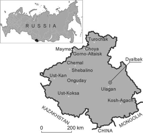
The site is located on the slope of Mount Dyalbak (Alt. jalbak ‘wide, flat; plateau’ (Molchanova, 1979: 175)), in the northeastern outskirts of the village of Balyktuyul in the Ulagansky District (Fig. 1, 2). The images are engraved on the horizontal planes of the Devonian limestone, slightly projecting over the modern surface (Fig. 3, A ). The planes with images are overgrown with lichens and show fissures. The petroglyphs were found in 1979 by V. Butvilovsky, a member of the Kurai Geological Team. Two years later, archaeologist A.S. Vasyutin studied this site. Information on the site is provided in his field report currently kept in the archive of the Institute of Archaeology RAS (R-1, No. 8571). In the scientific literature, there are only several short notes concerning this site (Vasyutin, 1983; Kubarev V.D., Matochkin, 1992: 58).
We have partially cleaned the planes of lichens, and documented the petroglyphs. The recorded subjects and images were added to the repertoire of the visual sources dating to the early medieval period. Furthermore, visual observations allowed us to assess the state of the planes with rock images and to propose measures aimed at the preservation of the site.
Materials and methods
Methods of documenting
The site was examined in 2017: engravings on the planes were photo-recorded, GPS-coordinates of two planes with images were identified, and a plan of the site was made. In October 2018, the site was re-examined, certain previously unknown planes with images were found, and images were recorded. Because of the lichens, some compositions could not be distinguished; therefore, some areas of the plane surfaces were cleaned with the aid of pointed wooden sticks.
Photography was carried out under oblique lighting, according to the method successfully used at many petroglyph sites (Miklashevich, Bove, 2014: 75). The works were carried out under natural light in the mornings and evenings, i.e. with different directions of light. Some details of the engravings were photographed using external flash. Photography was carried out with the reflex camera Nikon D3200 with high-aperture lens Nikon AF-S DX NIKKOR 35mm f/1.8G, with fixed
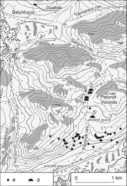
Fig. 1. Location of Dyalbak petroglyphs ( A ) and petroglyphs near Balyktuyul in 2017–2018 ( B ). a – petroglyphs; b – Pazyryk mounds.
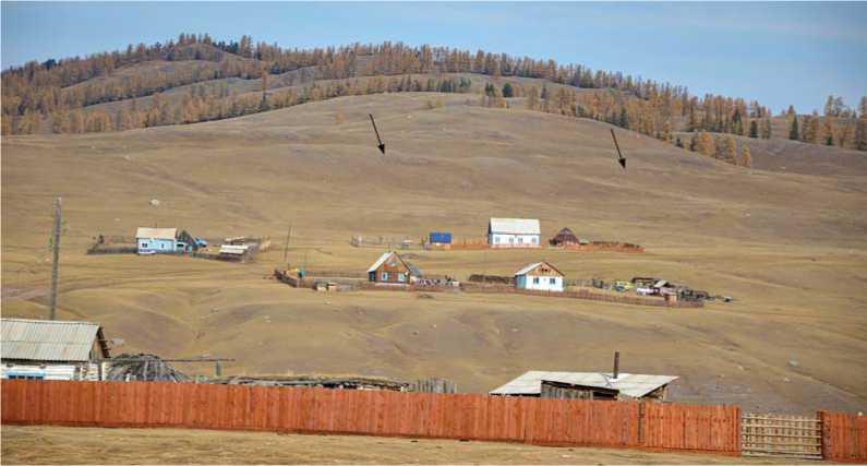
Fig. 2. Dyalbak Mount (arrows point to petroglyph location on the slope). View from the south.
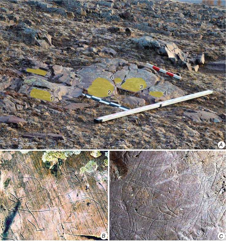
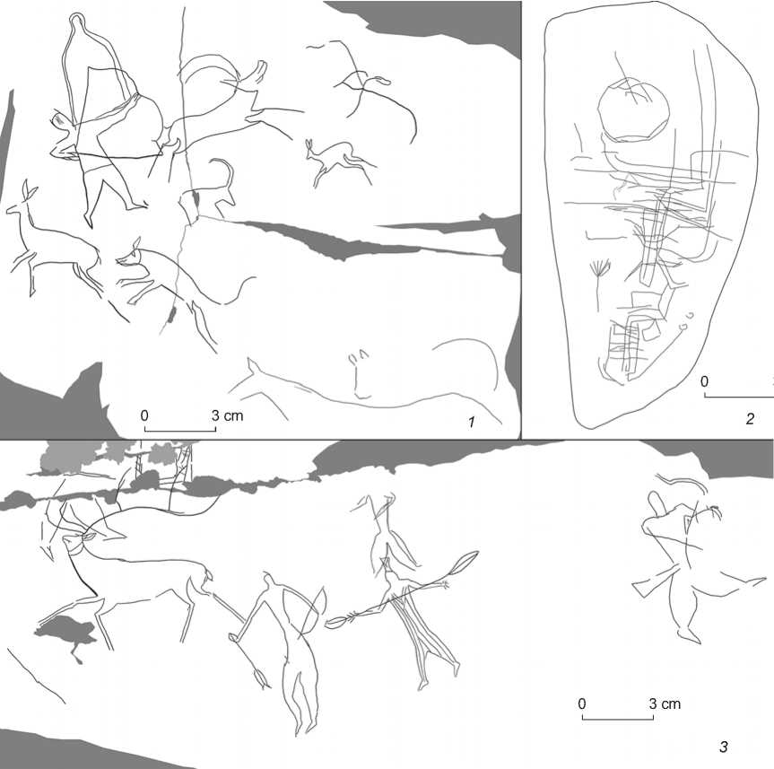
Fig. 3. General view on stone 1 ( A ) and details of compositions ( B , C ).
A – rock exposure (planes with engravings are designated with filling and numerals); B – hunting scene on plane 1; C – detail of fighting scene between a horseman and a unmounted warrior on plane 3.
focal length, and an ordinary zoom lens Nikon AF-S DX Nikkor 18-105mm f/3.5-5.6G. Photography was executed in the orthogonal plane for subsequent tracing in graphical computer programs.
After splicing the individual images in the graphical computer programs, trace-drawing was performed on an Apple iPad 2018 tablet computer. This tablet has a pressure-sensitive screen, so that the thickness of the line when drawing is set by the pressure of a stylus. In this case, there is no need to interrupt drawing to switch the thickness of the line when the thickness of the engraved line changes, which speeds up the copying process. The rendering on the tablet was performed in the Procreate program, and additional computer processing was also done.
State of the planes
The petroglyphs of Mount Dyalbak are located on the planes of four rock outcrops and a separate comparatively small rounded stone of Devonian fine-grained polymict, partially schistose, red sandstone (Fig. 3). The planes with engravings are located almost at the level of the daylight surface and parallel to the mountain’s slope. The rocks with petroglyphs are vegetated by various lithophytes, growing in fissures; some areas of the stone surface are covered with soil and crustaceous lichens; some areas show split-off edges, caverns, and modern images in the form of vague lines and sketches. The planes are covered with numerous gravitational fractures, with their widths from less than 1 millimeter to several centimeters. Large, curved, ragged fissures filled with soil run across the planes. There are areas with exfoliated cortex and scaly peelings, which processes cause rapid degradation of the rock. The homogenous reddish-brown patina on the rock’s surface is ca 1 mm thick. The patina’s color is lighter on the areas covered with lichens; this was noted when the vegetation was removed.
The rock art site is situated in situ , in the historical and natural context affected by hydrological, geochemical, and biological processes producing their destructive impacts on the rock art. Atmospheric precipitates penetrate the porous rock structure. Under the sharp temperature drops, especially in spring and fall, the water in stone gets frozen and expands, causing deformations and destruction of the rocks. Dust and biological contaminants are imported into the fissures with precipitates, and this also leads to the rock destruction. The rock art site is located on the south-facing slope, and is subjected to intense insolation leading to temperature difference in the rock structure. Large lichen colonies produce organic acids and other rock damaging agents (Devlet E.G., 2002: 115–116). The last two factors also produce damaging effects on the rock’s surface.
The observed problems and the ongoing destructive trend, caused primarily by the frost and the biogenic weathering of the rock surfaces with petroglyphs, raise the question of the use of preventive measures for the conservation and preservation of the site. For example, it is necessary to ensure drainage of rainwater from the slope above the site to avoid accumulation of soil particles in the rock structure. For that, it is necessary to analyze the physical and chemical features of the rock through petrographic methods, carry out X-ray analysis, non-destructive ultrasound scanning of the rock surface, and Karsten’s analysis. The moisture accumulated on the rock outcrops triggers the growth of biological agents and physical cracking of rock surfaces, which are the main damaging factors. In order to prevent further destruction, direct conservation should be carried out, the fissures and caverns should be filled with siliceous-organic matter, and the exfoliating cortex should be flanged to avoid dust and biological contamination of the rock’s structure.
Importantly, the rock art site is located in the immediate vicinity of the village and is subjected to permanent anthropogenic impact. Goats and sheep moving along the slope raise dust that accumulates on the planes, trigger stone-falls, and produce scratches and waste products in the form of excrement and urine. The chemical composition of the urine might affect the mineral composition of the rock surface and cause salt formation (Ibid.: 113–115).
Description of the planes
Stone 1. It is located in the western part of the site. The rock exposure is 2.4 × 1.7 m in size. The images are engraved on the flat areas between the fissured and uneven parts of the stone surface.
Plane 1. It is located in the western part of the rock outcrop (Fig. 3, A ). The plane is slightly inclined down to the slope and faces south. The upper part of the plane shows an unmounted archer hunting a mountain goat (Fig. 3, B ; Fig. 4, 1 ). Over the archer’s stretched out arm, a yurt (?) is depicted. The engravings include images of a wild boar and other ungulates. A vague zoomorphic image engraved with thin lines can be noted in the lower part of the plane.
Plane 2. It is located in the southeastern part of the rock outcrop (see Fig. 3, A ). In the central part, there is a two-level combat composition (Fig. 5; 6, 1 ). The upper level shows a combat between a mounted lancebearer and a unmounted warrior. The lance-bearer wears a helmet with a high plume and an aventail (?) (see Fig. 3, C ). The lance has a pointed tip and a long triangular banner. The engraved image shows some details of the horse’s bridle, and the horse’s mane
3 cm
т
3 cm
3 cm
Fig. 4. Petroglyphs on stones 1, plane 1 ( 1 ), 5 ( 2 ), and 2 ( 3 ).
with three prominent spikes. Below, three unmounted warriors are shown, with two of them equipped with lances. The lance of the central warrior is depicted with a banner of triangular cut. This character is overlapped by the unfinished image of an animal. The upper and lower parts of the plane show images of various animals, among which mountain-goat images are the most vivid. In the lower portion, images of an archer and a yurt (?) are engraved (Fig. 7, 2 ).
Plane 3. The plane is in the southern part of the rock exposure (see Fig. 3, A ). A fighting (?) scene with unmounted warriors is rendered in the center of the plane (Fig. 8). Three archers, a lance-bearer (?), and one more character with a long object (bladed weapon?) are also visible. The plane has several animal images. Two isolated bow images are shown on the right and left (below) edges of the plane.
Plane 4. It is located in the southern portion of the rock outcrop. The plane bears engravings; it is separated from plane 3 by a deep fissure (see Fig. 3, A ). In the portion free of lichens, images of ungulates are visible (see Fig. 7, 1 ). The greater part of the images is hidden under the lichens.
Plane 5. The plane is in the northern part of the rock exposure (see Fig. 3, A ). The plane is dissected by fissures, two of which are deep; three parts of the plane are of varying heights. The plane shows two animal images, possibly a reindeer and a wild boar (Fig. 9). The reindeer image overlaps one more unfinished image of an animal.
Plane 6. It is separated from planes 2 and 3 by deep fissures (see Fig. 3, A ). Two images of ungulates are shown on the plane (see Fig. 7, 3) . The head of the larger animal is hidden under the lichens.
Stone 2. A narrow horizontal plane on the rock outcrop located northeast of stone 1. The size of the plane with
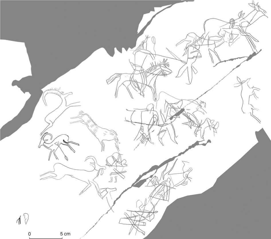
Fig. 5. Petroglyphs on stone 1, plane 2.
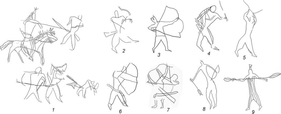
Fig. 6. Anthropomorphic images and a fighting scene on stones 1 ( 1–8 ) and 2 ( 9 ).
Fig. 7. Petroglyphs on stones 1, plane 4 ( 1 ), 2 ( 2 ), 6 ( 3 ), and 3 ( 4 ).
petroglyphs is ca 0.5 × 0.2 m. The plane bears several anthropomorphic images and a reindeer image (see Fig. 4, 3 ). Noteworthy is a human figure with vertical strips engraved on the body (see Fig. 6, 9 ). The strips likely represent clothing; they are limited by the “V-cut of the neck”. Some engraved images on the upper edge of the plane are covered by lichens.
Stone 3. A small horizontal plane of subtriangular form is located in the eastern part of the site, to the northwest of stone 4. The plane’s size is 0.3 × 0.4 m. It shows an engraved side-view anthropomorphic (?) image (see Fig. 7, 4 ). The character is shown with long hair, which is crossed by three lines. One short line represents some object in the hands of the character.
Stone 4. It is located in the eastern portion of the site. There are quite few isolated horizontal rock planes here.
The size of this plane is 4.3 × 1.6 m, its long axis runs along the W-E line.
Plane 1. The northern edge of the central part of the plane shows a pair of Siberian stags, male and female, facing each other (Fig. 10, 1 ).
Plane 2. The western part of the plane shows an engraved image of a two-wheeled chariot. The axle and pull-tongue are depicted by several incised lines. At the end of the pull-tongue, a device for fastening draught animals is shown by a curved line (Fig. 10, 2 ).
Plane 3. In the eastern part of this stone, there is the image of an archer. At some distance from the archer, images of some object (a quiver?), covered with incised lines, and arrows are represented (Fig. 10, 3 ).
Stone 5. A separate, comparatively small rounded stone is located 0.5 m to the southeast of stone 4.
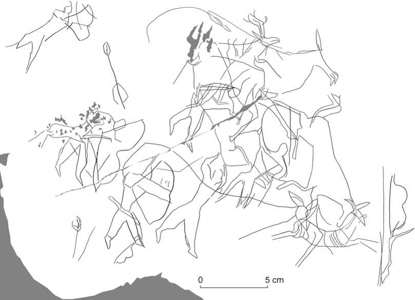
Fig. 8. Petroglyphs on stone 1, plane 3.
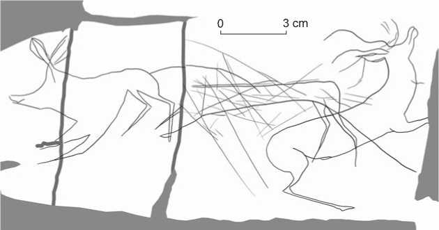
Fig. 9. Petroglyphs on stone 1, plane 5.
Lines are engraved on the flat surface of this pebble (see Fig. 4, 2 ). Regrettably, the image of the whole figure can hardly be detected.
Dating and parallels to the Dyalbak petroglyphs
All the images were executed with the engraving technique (Miklashevich, 2012: 158). The majority of the images belong to the early medieval period; several petroglyphs have been attributed to other periods. However, the images of different periods do not differ in color of incised lines or extent of patination. This is explained by the fact that the lines incised on the Devonian sandstone surface without refreshing soon become vague as a result of weathering and patina-formation (Mukhareva, 2017: 127). In addition, the patina color of some engravings vanished under the lichens. The chronological attribution of the images was based on their style, typical motifs, and images.
The chariot image on stone 4 (see Fig. 10, 2) should be considered the earliest one. Similar images were widely distributed in Eurasia (Novozhenov, 2012). The representations found in Central Asia are attributed mainly to the Late Bronze Age (Kubarev V.D., 2004: 16); though some of them are associated with the beginning of the Early Scythian time (Chugunov, 2008: 65). Rock images were mainly made using pecking technique; engraving was often used in depiction of chariots and their elements (Cheremisin, 2006: 94, fig. 1–8).
The youngest images among the Dyalbak petroglyphs are the engravings on the small rounded stone 5 (see Fig. 4, 2 ), located close to stone 4. These images have been preliminarily dated to the recent historical past (Grichan, 1987; Devlet M.A., 1988).
The majority of the images have been attributed to the Early Middle Ages. In general, this is a petroglyph site of the Turkic period. Nearly 20 rock images are anthropomorphic. Some of them are involved in fighting and hunting scenes. For example, the engraved anthropomorphic images are clearly visible in the two hunting scenes with pedestrian archers and mountain goats on stone 1 (planes 1 and 2) (see Fig. 4, 1 ; 5). Two battle compositions were noted on stone 1 (planes 2 and 3). The heroes of these scenes are a horseman and unmounted warriors. The image of the horseman and his horse shows many details. The two warriors in the scene on stone 2 bear lances with banners of various shapes (see Fig. 6, 1 ). The mounted knight with a lance bears a long triangular banner; the pedestrian one has a standard of a complicated form with a V-notch. The banner-bearer images are also typical of Central Asian rock art. A wide variety of banner shapes known from petroglyphs (Sovetova, Mukhareva, 2005: 95) makes it difficult to determine which particular shapes were used by population groups of Central Asia and southern Siberia in the Turkic period.
The battle scene on plane 3 shows archers, a lancebearer, and a warrior equipped with an allegedly bladed weapon (see Fig. 6, 4 ). All the archers engraved at Dyalbak are equipped with M-shaped bows (see Fig. 6). In most cases, the bow-ends and a drawn bow-string are vividly depicted. Some images show bow-cases and quivers attached to the belts of the anthropomorphic characters (see Fig. 6, 2 , 6 , 7 ).
Noteworthy also are two isolated bow images on plane 3 (see Fig. 8) and a quiver on stone 4 (see Fig. 10, 3 ); these can be considered a demonstration of the weapon cult (Kubarev V.D., 2003: 26). Separate images of quivers and bow-cases are known from the early medieval petroglyphs, but there they are usually associated with
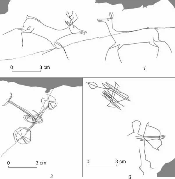
Fig. 10. Petroglyphs on stone 4, planes 1 ( 1 ), 2 ( 2 ), and 3 ( 3 ).
the humans involved in the compositions (Kubarev G.V., 1998: 191, fig. 3).
Among the anthropomorphic images, two figures are of special interest. One of these is located in the center of the plane on stone 2 (see Fig. 6, 9 ). The body of this character is covered with longitudinal lines, and a V-neck is shown on the breast; the character bears a long headgear with a straight top and a triangular “cut” inside; the arms are stretched out with the fingers apart. The hands hold an elongated item reminiscent of an arrow with head and fletching. The other anthropomorphic figure is shown in side view on stone 3 (see Fig. 7, 4 ). Its body is covered with hatching; the long hair is “bound” with three crosslines. In the upper part of the body, there are several cross-lines. The character holds a small elongated item in its hands. The attribution of the first figure to the Early Middle Ages is undoubted, but the chronological attribution of the second is not so obvious. On the basis of the some special features, this second image can be dated to the Turkic period.
Noteworthy are two images on stone 1: possibly these are yurts. The first image is located on plane 1 (see Fig. 3, B ). The image is depicted above the hunter’s shoulder and arm (on the background?). The walls and roof of the yurt are shown with a double line, the bottom with a single line. In the upper part, there is a protrusion representing a chimney. Plane 2 also contains a yurt image (see Fig. 7, 2 ).
The triangular image is shaded with several slanting lines. A rounded protrusion in the upper part possibly represents a chimney. The yurt images are comparatively rare; these are known from the visual sources of the Early Middle Ages (Hudiakov, Tabaldiev, Soltonbaev, 1997: Fig. 2, 2 ; Kubarev G.V., 2003; Mukhareva, Sovetova, 2012: 73–74, fig. 7, 8).
Among the abundant images of ungulates, the images of mountain goats, and of reindeer with antlers, are noteworthy. Images of hornless hoofed animals (reindeer?) are more numerous. Two images on planes 1 and 5 apparently represent wild boars. A pair of Siberian stags, male and female, facing each other is of special interest. This scene is possibly related to the fertility cult.
Conclusions
The Dyalbak site in Eastern Altai contains wonderful rock art images of the Early Middle Ages. The majority of the engravings date to this time; however, there are also separate images related to other periods. The earliest image is that of a chariot dating to the Late Bronze Age. Apparently, the rock outcrops on the mountain slope attracted the attention of the ancient artists exactly at this period.
There are popular motifs of Turkic art here: scenes of fighting, hunting, and “meeting” between male and female Siberian stags. Certain images and motifs can be related to the cult of weapons (isolated bow images) and fertility (a paired image of Siberian stags). Some engravings, owing to their detailed representation, can be used for the reconstruction of outfit, weapon kit, riding horse equipment, etc.
The significant areas of the planes with petroglyphs were covered with lichens; we managed to clean some parts. However, several images remained hidden. Subsequent cleaning of the remaining areas with lichens will provide additional information on the motifs and images. In future, it is planned to monitor changes of the cleaned areas and state of the planes’ preservation.
The study of the Dyalbak petroglyphs adds to our knowledge of the rock art repertory in the Altai. Visual observations of the state of planes’ preservation made it possible to determine the main threats and to propose measures aimed at their prevention.
Acknowledgement
This study was supported by the RF President grant for the state support of young Russian scholars, MK-1413.2019.6.
