Remain s of tapestry from a Xiongnu (early 1st century ad) burial in mound 22 at Noin-Ula
 burial in mound 22 at Noin-Ula")
Author: Polosmak N.V., Karpova E.A.
Journal: Archaeology, Ethnology & Anthropology of Eurasia @journal-aeae-en
Section: The metal ages and medieval period
Article in issue: 4 т.44, 2016.
Free access
Short address: https://sciup.org/145145285
IDR: 145145285 | DOI: 10.17746/1563-0110.2016.44.4.076-082
Text of the review article Remain s of tapestry from a Xiongnu (early 1st century ad) burial in mound 22 at Noin-Ula
Relief and climate changes, plus sedimentological and hydrological processes that took place during the time of existence of archaeological sites, form the topics of questions, the answers to which determine the success of archaeological studies—from the stages of reconnaissance survey and problem-setting to interpretation of results. At the same time, archaeological research can be a source of valuable information for characterizing paleolandscapes and for dating quaternary deposits and landforms.
The Altai upland was a geographical center of ancient cultures and civilizations located in the contact area between the East and the West. The southeastern part of the Russian Altai (the Altai Mountains) considered in this article includes the Kurai-Chuya system of basins and their framing ridges. The ridges reach an elevation of 3900–4300 m a.s.l. and represent one of the contemporary glaciation centers of Altai. The bottom of the Chuya basin lies in the elevation range of 1750 to 2000 m a.s.l., while that of the Kurai basin lies in the range of 1500 to 1650 m. The depressions are separated by the Chagan-Uzun massif, an independent tectonic block characterized by high seismotectonic activity during the Late Neopleistocene and Holocene.
The bottoms of the Kurai and Chuya basins and the valleys of framing ridges are an area of numerous archaeological sites belonging to different epochs from the Paleolithic to the Middle Ages. Nevertheless, the cataclysmic draining—the most powerful on the Earth—of the ice-dammed reservoirs that existed here in the Neopleistocene (Butvilovsky, 1993; Rudoy, 2005; and others), and the hydrological system’s transformation in the Holocene, considerably less broad-scale but no less important for distribution of people (Rusanov, 2010; Agatova et al., 2016), have been modeled exactly for this territory. Despite a high degree of geomorphological certainty as to the Southeastern Altai, the chronology of the natural events during the Neopleistocene and Holocene in this region is a matter for considerable debate, which often assigns the roles of age-markers to the archaeological sites. However, the Chuya and Kurai basins have been explored irregularly in terms of the mapping of archaeological sites. At present, the eastern and southern parts of the Chuya depression, where a huge number of sites belonging to various cultures are concentrated, are the best-studied. In the Kurai basin, a number of archaeological sites of the Scythian and Xiongnu epochs, and Kyrgyz period have been investigated. In the Chuya River valley, in the area between the depressions, sites belonging to the Upper Paleolithic, 6th–10th centuries AD, and to the Kyrgyz culture are known. However, publications containing descriptions and definitions of the cultural affiliations of archaeological objects in the central part of the Chuya depression, a considerable part of the Kurai depression, and the Chuya valley between the depressions (except for the mouth of the Kuektanar River), are almost absent.
This article presents the results of a multidisciplinary study of the Kurai-Chuya system of intermountain depressions, using geomorphological, paleontological, geoarchaeological, and geochronological (radiocarbon and dendrochronological) methods. The issues of the existence in these depressions of Holocene lake basins, closely related to the evolution of the Neopleistocene glacio-lacustrine system, are discussed. Particular emphasis has been placed on studying the geomorphological structure of the Chuya valley between depressions and the distribution of archaeological sites in this area; because, according to the majority of researchers, the dams that impounded the lakes in the Chuya basin in the Neopleistocene and Holocene were formed exactly here.
Debating-points concerning the existence of archaeological cultures and the reconstruction of the limnosystems of the Kurai and Chuya basins in the Neopleistocene and Holocene
The existence of archaeological cultures in the Kurai and Chuya basins is directly related to the climate-responsive evolution of the hydrological system of these depressions in the Neopleistocene and Holocene. Glaciations and ice-dammed lakes formed in the depressions became the main factor for morpholithogenesis within this territory during the Neopleistocene. At 2100 m a.s.l., a single icedammed reservoir fully occupied the bottoms of both basins. Obviously, the chronology and character of the draining of the Neopleistocene lakes determine the possibility of finding the most ancient sites in this territory. Currently, however, there is no consensus on the times of the glaciations, nor on the chronology, number, and character of the drying-events for the icedammed lakes; and the last large lake(s) in the basins is dated both to the Sartan period (MIS 2) and to the beginning of Würm (MIS 4)*.
Hydrological changes in the Holocene within the territory under study were closely related to the evolution of the Neopleistocene glacio-limnosystem. According to studies conducted by G.G. Rusanov (2010), an extensive lake also existed in the Chuya depression for much of the Holocene. During the period of its maximum water-level, the lake occupied the central part of the depression up to an altitude of 1800 m a.s.l., as confirmed by abrasion-terraces and the spread of lacustrine sediments, along with Late Neopleistocene-Holocene fauna of ostracods in the range from 1760 to 1800 m a.s.l. The lake’s depth changed from the first meters in the southeastern part of the basin to 80 m in the Chuya valley; the volume of water was at least 3.5 km3, and the area reached more than 100 km2. According to Rusanov, the lake’s level could have decreased to at least 1765 m a.s.l. in the subboreal period of the Late Holocene (4500– 2500 BP) as a result of partial erosion of landslidemoraine dam located in the Chuya valley near the Kuektanar’s mouth; however, the lake continued to exist for long time after this. In this researcher’s opinion, the cataclysmic drying of the lake, which possibly occurred no more than 1000 BP, could have been caused by a large seismic landslide, which fell down into water reservoir not far from the dam.
Obviously, the existence of such a lake and the supposed abrupt changes of its level were bound to affect the distribution of people not only in the Chuya basin, but also in the Kurai basin located downstream (the Chuya River), as well as in the Chuya valley between them. At the same time, preliminary studies, using (among others) the geoarchaeological method (Agatova et al., 2016), have revealed a number of issues relating to the possible existence of a single lake in the Chuya basin in the Holocene; the chronology of its level’s recessions; the time, causes, and character of its final drying.
Thus, the reconstruction of the landscapes that determined the distribution of people in the area of Southeastern Altai in the Holocene requires information not only about climatic fluctuations, but also about the evolution of the hydrological system, along with geochronological data.
Results of geomorphological and geoarchaeological studies and their interpretation
To reconstruct the parameters of the Chuya lake’s basin in the Holocene and to determine the time and character of its draining we have carried out an analysis of geological evidence and the in situ locations of the archaeological sites in the Chuya depression, in the Chuya valley between the depressions where the landslide-moraine dam was located, and in the eastern part of the Kurai depression (which is the zone of potential influence of the cataclysmic draining of lake approximately 1000 BP, according to the suggestion made by Rusanov (2010)).
Chuya basin. Judging by the age of the buried peat horizon overlying the moraine sediments liable to seismically induced sliding on the right bank of the Boguty River (the Chikhachev ridge) at an elevation of 2500 m a.s.l., which was studied by us, the Sartan glaciers in the eastern framing of the basin retreated above 2500 m a.s.l. as early as 13786 ± 166 cal BP (IGAN-4098 (see Table )); which disproves the existence of an ice-sheet 14 ka cal BP (Rudoy, 2005: Fig. 6). The level of the ice-dammed lake (if it existed here then) was below this mark. In the period of approx. 8.8–8.0 ka cal BP (SOAN-8674, IGAN-4089, IGAN-4091), soil-cover was forming and forest was growing at an altitude of 2470 m a.s.l. on the Chikhachev ridge. Accordingly, lake systems in the Chuya basin could have existed only below this mark at that time. Finding a paleosol horizon in the sediments of the Yustyd floodplain at an elevation of 1951 m a.s.l. is indicative of the absence of a large reservoir in the eastern part of the basin 2150 ± 146 cal BP (SOAN-8423).
In comparison with the peripheral parts of the Chuya depression, which rise smoothly to the ridges, the bottom of it contains a considerably smaller number of archaeological sites dated to the second half of the Holocene. Quite definitely, the sites are concentrated in the depression’s eastern and central parts; i.e. beyond the limits of areas unfavorable for life-activities, such as lakes, frost mounds, and bogs, which existed rather recently at the permafrost degradation locations. In the western part of the basin, in contrast to presentday settlements, no traces of earlier human presence (burials, ritual complexes, iron-melting or ceramic furnaces) have been noted directly along the Chuya River. Also, another trend is observed here: more recent archaeological sites are located structurally lower than those of the Late Bronze Age, while the low limit of their distribution is 1753 m a.s.l.
The most ancient and low-level in situ site in the Chuya basin has been recorded southeast of the Mukhor-Tarkhata village, between the proluvial cones of the Tarkhata and Kokozek rivers, at an altitude of 1770 m a.s.l. These rock-fills 20 and 40 m in diameter, round in plan, are presumably attributable to the Late
Radiocarbon dates obtained in the course of studies
|
Laboratory No. |
Location of sampling |
Elevation a.s.l., m |
Sample type |
Date * |
|
IGAN-4098 |
Valley of the Boguta River, Chikhachev ridge, eastern |
2500 |
Paleopeat |
11,910 ± 70 (13,786 ± 166) |
|
IGAN-4089 |
framing of the Chuya basin |
2470 |
Charcoal |
7780 ± 75 (8629 ± 226) |
|
IGAN-4091 |
2470 |
Paleosol |
7350 ± 90 (8179 ± 179) |
|
|
SOAN-8674 |
2470 |
Charcoal in paleosol |
7640 ± 100 (8415 ± 212) |
|
|
SOAN-8423 |
Valley of the Yustyd River, the Chuya basin |
1951 |
Paleosol in alluvial floodplain sediments |
2130 ± 25 (2150 ± 146) |
|
IGAN-4131 |
Valley of the Chuya River between the Kurai and Chuya basins in the |
1740 |
Vegetative detritus |
850 ± 90 (796 ± 137) |
|
IGAN-4132 |
Kuektanar River mouth |
1740 |
Same |
2390 ± 70 (2517 ± 199) |
|
IGAN-4133 |
1720 |
" |
2310 ± 60 (2403 ± 253) |
|
|
IGAN-4134 |
1740 |
" |
650 ± 70 (611 ± 86) |
|
|
IGAN-4138 |
1720 |
Fragments of tender roots |
1680 ± 60 (1565 ± 149) |
|
|
IGAN-4139 |
1750 |
Charcoal and vegetative detritus |
1530 ± 70 (1426 ± 125) |
|
|
IGAN-4140 |
1750 |
Charcoal |
1290 ± 70 (1192 ± 135) |
|
|
IGAN 4141 |
1720 |
Fragment of tree root |
290 ± 60 (325 ± 176) |
|
|
SOAN-8715 |
1730 |
Paleosol with charcoal |
3330 ± 65 (3558 ± 157) |
|
|
SOAN-9091 |
1725 |
Charcoal |
1250 ± 65 (1152 ± 143) |
|
|
SOAN-8903 |
Valley of the Chuya River between the Kurai and Chuya basins |
1735 |
Paleosol |
7440 ± 95 (8223 ± 181) |
|
SOAN-9090 |
downstream of the Kuektanar |
1650 |
" |
350 ± 65 (403 ± 108) |
|
SOAN-9092 |
River mouth |
1670 |
Paleosol with charcoal |
1060 ± 45 (951 ± 116) |
|
SOAN-9093 |
1670 |
Charcoal |
890 ± 30 (821 ± 87) |
|
|
SOAN-9098 |
1635 |
Paleosol |
1250 ± 30 (1178 ± 96) |
|
|
SOAN-9100 |
1635 |
" |
2835 ± 55 (2966 ± 174) |
|
|
SOAN-9086 |
Valley of the Arydzhan River, the Kurai basin |
1720 |
Paleosol in alluvial-proluvial sediments |
7910 ± 70 (8791 ± 200) |
|
SOAN-8424 |
Valley of the Tadzhilu River, the Kurai basin |
1568 |
Paleosol in diluvial sediments |
3415 ± 65 (3694 ± 142) |
|
SOAN-8549 |
Valley of the Chuya River, the western part of the Kurai basin |
1470 |
Paleosol in proluvial-colluvial sediments |
3275 ± 80 (3525 ± 168) |
|
SOAN-8681 |
Valley of the Chuya River in the Baratal river Mouth, the western |
1465 |
Paleosol |
5650 ± 90 (6466 ± 177) |
|
SOAN-9094 |
part of the Kurai basin |
1475 |
Buried medium gravel humus horizon |
8770 ± 140 (9861 ± 324) |
|
SOAN-9096 |
1460 |
Paleosol |
4560 ± 75 (5220 ± 247) |
|
|
SOAN-9097 |
1460 |
" |
5470 ± 160 (6274 ± 357) |
|
|
NSKA-00988 |
1460 |
Collagen |
9584 ± 31 (10,930 ± 171) |
*2σ-calibrated values are shown in brackets.
Bronze Age and the beginning of the Early Iron Age. They consist of small boulders and pebbles, and their contours are outlined by numerous pairs of large boulders. This vast archaeological complex includes chains of Pazyryk mounds, Turkic funeral enclosures, and objects with unidentified cultural affiliations. Pazyryk mounds, characterized by the lowest location (1764 m a.s.l.) within the Chuya basin, have been recorded both here, and also on the left bank of Chuya River, 2 km south of Ortolyk village, and on the right bank of the Chagan-Uzun River. The lower limit of the distribution of Old Turkic sites known to date is an elevation of 1753 m a.s.l. (the Chagan-Uzun basin).
The locations of sites attributed to various cultures indicate that the level of the lake in the middle of the Chuya basin, which was suggested by Rusanov (2010), in the Late Bronze Age could have not been higher than 1770 m a.s.l., and did not exceed 1764 m a.s.l. in the Scythian epoch, or 1753 m a.s.l. in the Turkic epoch. Generally, their locations point rather to the local character of lakes here, and unfavorable developmental conditions in the western part of the basin during the last third of the Holocene.
Chuya valley between the Chuya and Kurai basins. In this area, the valley represents a graben separating the Kurai ridge and the Chagan-Uzun massif. Both graben shoulders are complicated by numerous seismically induced landslides, rockfalls, and large talus fans. The coastlines, preserved at elevations up to 2100 m a.s.l., attest to the existence of a single Kurai-Chuya basin during certain developmental stages of the glacio-limnosystem. The graben is divided structurally into three sections (Fig. 1).
In the first, the narrowest area, from the Chuya basin mouth to the Meshtuyaryk’s mouth, the graben’s width along the 1800 m a.s.l. isoline (the maximum level of the proposed Holocene lake) does not exceed 870 m. Numerous landslides and rockfalls occupy both slopes along their entire length. Areal sliding of the Neogene sediments from the lower tectonic bench of the Kurai ridge, from the elevation of 2100 m a.s.l., is observed. The Chuya River is slightly incised into boulder-pebble-sandy deposits, and it meanders. No traces of landslide dams have been recorded by us in this area. Archaeological sites have not been discovered either.
The second area, from the Meshtuyaryk’s mouth to the place of incision into moraines of the Kuektanar glacier, is characterized by the graben’s widening along the 1800 m a.s.l. isoline up to 3.5 km, and by the sharp deepening of the Chuya’s bed up to 40–45 m in the location where the moraine is cut. In spite of this maximum width, the dam composed by the Kuektanar glacier moraines and the giant Sukor landslide was formed exactly in this part of the graben. On the left bank of the Chuya, the landslide sediments partially overlie the moraine; and on the right bank, downstream of the Kuektanar mouth, they lie in the thickness of the glacial deposits, obviously sharing their age. At present, moraine and landslide sediments reach the altitude of 1800 m a.s.l. only in the slope parts of the valley, while in the central part, their elevation does not exceed 1750–1760 m a.s.l. The terraced character of the Sukor landslide’s surface up to an altitude of 1800 m a.s.l. points to its formation, and the partial erosion of the landslide-moraine dam, even before the draining of the reservoir, with the water’s edge not lower than 1800 m a.s.l.—equal for both basins at that time. The “rock garden” on the left-bank terrace upstream of the landslide body is indicative of the passage of high-energy floods in this area of valley. After the drying (or level decreasing) of the single water reservoir, the dam could have impounded the lake in the Chuya basin with the water surface not higher than 1750 m a.s.l. The age of paleosol (SOAN-8903) at the base of the subaerial sequence lying on top of the lacustrine sediments at an altitude of 1730 m a.s.l. (Fig. 1, section 3) indicates that if the lake above the dam still existed around 8 ka cal BP, its edge was below 1730 m a.s.l.; and it was local, since the Chuya basin’s bottom is located above this mark. Thus, as early as 8 ka cal BP, the dam in the Kuektanar mouth could not have impounded the lake in the Chuya valley, while no traces of another possible dam have been discovered higher in the valley.
The obtained radiocarbon dates imply formation of the cover subaerial complex in the considered area of the valley in the Holocene (Fig. 1, sections 1–4), as well as fluctuations of the Chuya bed and active erosion of ancient lacustrine sediments during the last third of the Holocene (Fig. 1, section 5). The disappearance, by the 6th–10th centuries AD, of any lakes here (SOAN-9091) is also evidenced by a number of iron-melting furnaces along the right coastal cliff of the river at 1720–1730 m a.s.l. These are the Kuekhtonar-1, -2 sites (Zinyakov, 1988: 46–49) and the previously unknown location below the Kuekhtonar River’s mouth, which we identified on the basis of the ground’s calcination to a bright crimson color (Fig. 1). No later than the 15th–16th centuries AD (IGAN-4141), the sand-massif on the right bank of Chuya was colonized by trees. Scattered finds attributable to the Paleolithic and the Kyrgyz culture were collected among the dunes (Derevianko, Markin, 1987: 11–12; Hudiakov,
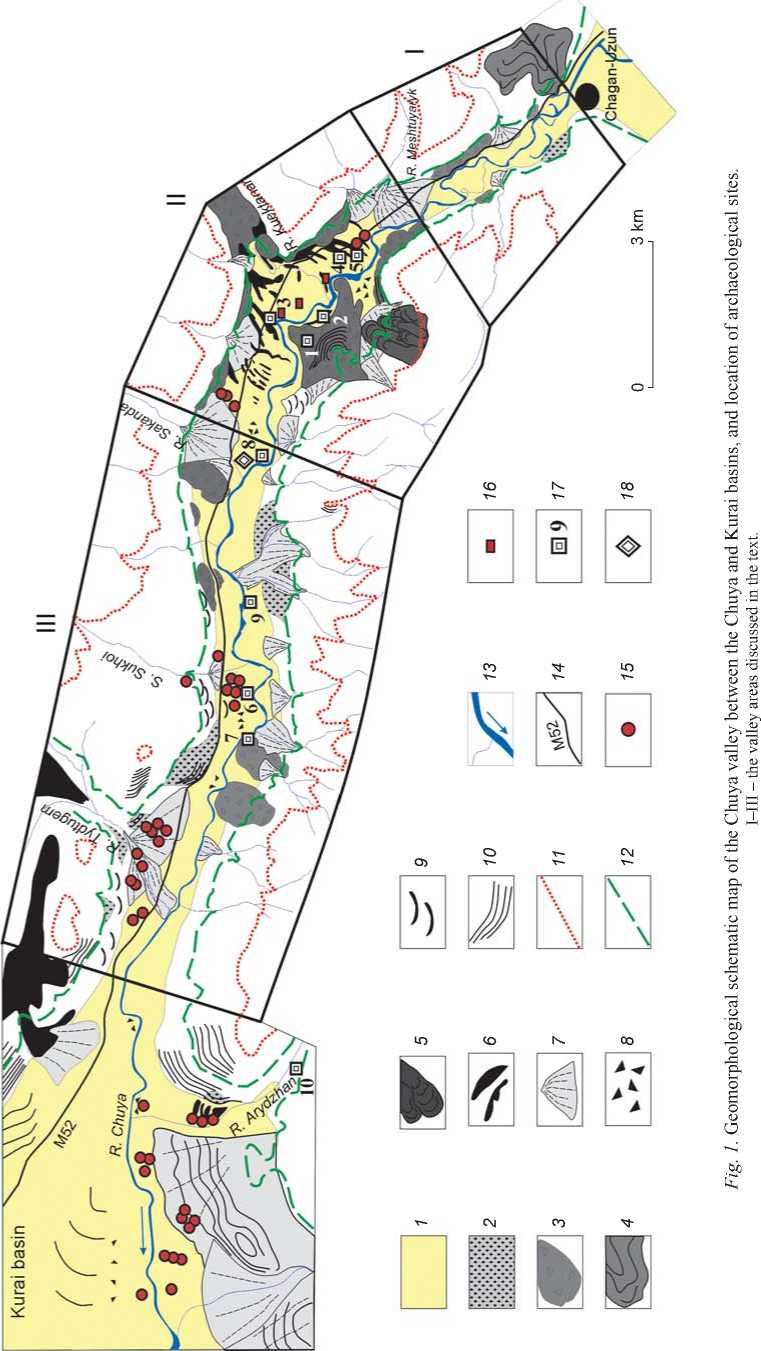
1 — sediments of the basin-bottoms and Chuya valley; 2 – terraces eroded in the Late Neopleistocene (?) lacustrine sediments; 3 – landslides, slumps, rock avalanches; 4 – landslides of Neogene lacustrine sediments; 5 – rock glaciers; 6 – moraines; 7 – proluvial cones and aprons; 8 – accumulations of blocks and boulders (“rock gardens”) tracing the passage of disastrous floods; 9 – bedrock slopes treated by water-flows; 10 – abrasion lake terraces modeling soft sediments; 11 – paleolake level of 2100 m a.s.l.; 12 – paleolake level of 1800 m a.s.l.; 13 – present-day hydrological system; 14 – federal highway M52; 15 – archaeological complexes; 16 – location of iron-melting furnaces; 17 – location of studied sections; 18 – place where dendrogeomorphological analysis was conducted.
1990). At the place of their discovery, on the surface of the Chuya six-meter terrace, we have recorded an in situ archaeological object—round spreads of stones (at least three of them) up to 2 m in diameter, partially covered by sand. The determination of the object’s cultural affiliation is difficult; however, we can assume that it is relatively recent, which points to high activity of aeolian processes during the last millennium. No evidence of landslide that, according to the hypothesis of Rusanov (2010), could have caused a wave that resulted in destruction of the landslide-moraine dam and in drying the lake about 1000 BP, has been discovered in the area of this valley.
The third area extends from the dam to the outlet into the Kurai basin. The valley’s width along the 1800 m a.s.l. isoline is 1.6–1.9 km here. The lake (wave-cut and accumulative) and river (erosion and erosion-accumulative) terraces, formed in the period of existence of Neopleistocene lakes and in the course of post-lake incision, represent a typical feature of this area. Abrasion-levels on the accumulative lake terrace with a surface elevation of 1700–1750 m a.s.l. in the Tydtugem’s mouth suggest the existence of several lake epochs in the Neopleistocene. The lower lake terrace (1610 m a.s.l.) traced in the Kurai basin shaves off the proluvial cone of the Tydtugem River, which indicates formation of its distal part during the interlacustrine stage. Accumulations of large pieces of rock (up to blocks) of different petrographic composition on medium-height terraces indicate the passage of powerful floods across the valley. The Chuya incision into ancient lacustrine sediments reaches ca 170 m here, with the water’s edge at 1582 m a.s.l.
Within the third area, several chains of Pazyryk mounds with balbals are located nearest to the Kuektanar dam, at a distance of 1000–1250 m from the highest moraine line, on the right-bank terrace (1740 m a.s.l.) along the edge of the proluvial cone of the Sakanda River. Numerous mounds and ritual structures of the Pazyryk and Old Turkic cultures are concentrated in the Sukhoi stream’s mouth on a terrace, at 1665–1670 m a.s.l. Some objects are situated not far from a steep 25-meter scarp, defining this terrace, 200 m away from the present-day Chuya’s bed. A single Pazyryk mound has been recorded on the rock bar of the Sukhoi stream valley, at an altitude of 1800 m a.s.l. Pazyryk cemeteries including large mounds, as well as Turkic funeral enclosures, are located on the proluvial cone of the Tydtugem, on both banks, at an elevation-range of 1630– 1650 m a.s.l. Mounds whose cultural affiliation cannot be determined by morphological characteristics have been recorded on a terrace of 1610 m a.s.l., shaving off this cone, and on a more recent nested proluvial cone. Meanwhile, their affiliation could, possibly, detail the chronology of the Holocene geological processes.
Downstream the Sukhoi stream’s mouth, seismically induced paleo-landslide on the left graben slope impounded the river, which resulted in formation of a local lake. The pre-Holocene age of the boulder stratum in the crest of a 15-meter right terrace of the Chuya River (Fig. 1, section 6), associated with one of the latest cataclysmic floods, is evidenced by the data of lacustrine sediments obtained by V.V. Butvilovsky (1993) (Fig. 1, section 7): 9717 ± 177 cal BP (SOAN-2378) and 8308 ± 110 cal BP (SOAN-2379). Drying of this landslide-dammed lake occurred no later than 3300–3000 cal BP (SOAN-9100). In the period of Turkic domination, soil was formed on the terrace surface again (SOAN-9098), while there was no overflow onto the 15-meter terrace itself (1633 m a.s.l.) during the last 3000 years; and possible severe floods did not go beyond the limits of Chuya’s bed in this area, as confirmed by preservation of funerary complexes (including elite Pazyryk mounds) on the next 25-meter terrace (1665–1670 m a.s.l.), including its crest.
Active migration of the Chuya’s bed downstream of the Kuektanar dam during the last 1000 years is evidenced by radiocarbon dates (SOAN-9092, SOAN-9093) of buried soils (Fig. 1, section 8) and by the results of dendrochronological analysis of cores and stem-discs of larch-trees, which colonized the floodplain. About 400 cal BP (SOAN-9090), the youngest paleosol was formed on the high left-bank floodplain upwards of the Sukhoi stream’s mouth. This paleosol was overlaid by thin alluvium in the course of subsequent short-term flood-flows of the Chuya (SOAN-9090; Fig. 1, section 9).
Kurai basin. In its western part near the Baratal ravine mouth, we have found paleosol on the surface of talus cone (1475 m a.s.l.) formed after the drying of the last ice-dammed lake in the Kurai basin. The soil is dated to 9861 ± 324 cal BP (SOAN-9094), thus indicating that this drying occurred as early as the beginning of the Holocene. Colluvium is overlapped by a 10-meter sequence of flat-bed clastic sediments, which accumulated near the slope’s foot in a water environment. The dates of paleosols in the sequence roof, such as 6466 ± 177 (SOAN-8681), 6274 ± 357 (SOAN-9097), and 5220 ± 247 cal BP (SOAN-9096), testify that a water reservoir with a level of at least 1480 m a.s.l. existed again in this part of the Kurai basin during the period between 10.0 and 6.5 ka cal BP. By the time of the erection of the
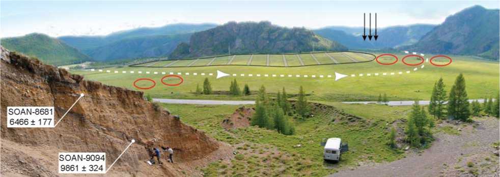
Fig. 2. The Chuya valley in the Baratal mouth.
Black arrows show the location of the glacial dam; stripes indicate Late Neopleistocene lacustrine sediments preserved around the bedrock exposures; white dashed line with arrows shows location of bed and direction of current of the pre-Chuya; red ovals show mounds of the Baratal-1 Pazyryk cemetery. Calibrated (2σ) radiocarbon dates characterize the age of paleosols at the right valley shoulder. The altitude is 1470 m a.s.l.
Borotal-1 Pazyryk mounds on the right-bank terrace of the Chuya (Kubarev, Shulga, 2007: 34–35, 180–185), the river channel, which earlier had extended along the right slope, had already taken the position close to the present-day one after moving to the valley’s center (Fig. 2). The radiocarbon age (SOAN-9086) of the lowest of paleosols, overlying the alluvial-proluvial sediments in the Arydzhan River valley (eastern part of the Kurai basin) at an altitude of 1720 m a.s.l. (see Fig. 1, section 10), allows the statement that, if the lake in Kurai depression existed about 9000 cal BP, its level was considerably lower than 1720 m a.s.l., and it did not enter into the western part of the Chuya basin. The moraine-complex lying at an elevation of approx. 1625 m a.s.l. in the Arydzhan valley mouth is nested within a thick proluvial cone and eroded away. Separate erratic boulders (probably traces of iceberg rafting) are encountered here on the Chagan-Uzun massif slope up to an altitude of 1760 m a.s.l., indicating the level of one of the latest Neopleistocene lakes in the basins. The buried soils aged about 3500– 3700 cal BP (SOAN-8424, SOAN-8549), overlying flood-disturbed sediments and proluvial-colluvial cone in the western part of the Kurai depression, suggest that all flood-events came to an end here in the second half of the Holocene.
Earlier unknown and numerous burials belonging to the Bulan-Koby culture of the Xiongnu epoch were recorded on the ancient proluvial cone terraced by lake-levels in the Arydzhan-Baltyrgan interfluve 1600–1610 m a.s.l. (60 m above the Chuya edge). Rock-fills ca 2 m in diameter, dominated by granite and marmorized limestone boulders, slightly bloom out on the sodded surface of the left-bank part of the cone. Both separate burials and northwest-trending chains of several graves are encountered. A vast field of similar burials, with mounds of marmorized limestone boulders, has also been discovered on the first rightbank terrace of Arydzhan 1615–1630 m a.s.l. Below the Arydzhan’s mouth, on the second Chuya terrace along both river banks (11–12 m above the river edge and no further than 250 m from it), Pazyryk and Old Turkic complexes are located, which suggests that all possible cataclysmic flows had taken place before their construction (see Fig. 1).
Conclusions
New chronometric data and mapping of in situ archaeological sites (which was carried out for the first time in the Chuya valley in the area between the Chuya and Kurai depressions and in the adjacent parts of the basins) have allowed specifying reconstructions of the geological processes in Southeastern Altai at the end of the late Neopleistocene and in the Holocene. More than 25 new radiocarbon dates attest to the formation of all studied paleosols, overlying lacustrine sediments within the Kurai-Chuya system, in the Holocene. These data allow no conclusions to be drawn about the chronology of the draining of the Neopleistocene ice-dammed lakes here. At the same time, it can be reasonably stated that the last single ice-dammed reservoir in the basins ceased to exist as early as the beginning of the Holocene. In the interval of 10.0–6.5 ka cal BP, a lake with a level not lower than 1480 m a.s.l. existed again in the western part of the Kurai depression; while the reservoir in the Chuya depression was desintegrated into isolated, though sizeable, lakes. Thus, in the first half of the Holocene, isolated lake-systems connected only by the Chuya River were located in the basins, while all possible cataclysmic outburst floods took place in the basins earlier than 10–8 ka cal BP. Hydrological system transformation in the second half of the Holocene proceeded without disastrous consequences for people.
