“Salt turn”—a toponym in the Middle Irtysh basin: historical and archaeological evidence

Author: Borodovsky A.P.
Journal: Archaeology, Ethnology & Anthropology of Eurasia @journal-aeae-en
Section: The metal ages and medieval period
Article in issue: 4 т.50, 2022.
Free access
Salt-related toponyms, Irtysh defense line, Salt Turn redoubt, lake salt mining, salt transportation, southwestern Siberia, Early Modern Age
Short address: https://sciup.org/145146806
IDR: 145146806 | DOI: 10.17746/1563-0110.2022.50.4.111-119
Text of the article “Salt turn”—a toponym in the Middle Irtysh basin: historical and archaeological evidence
The steppe territories of the south of the Middle Irtysh basin have always been the place of active and diverse economic activities (Kosarev, 1981: 21, 22). One of the industries was the extraction and transportation of deposited salt from the lakes of the Baraba foreststeppe and the Kulunda steppe (Volchek, 2006; Gefke, 2014; Vaskov, 2019, 2020). Notably, around the Irtysh river, according to the written documents of the 17th century, “there are so many salt lakes all over the area, they are countless” (Titov, 1890: 76). Generally, the number of salt lakes increases from north to south
(Zapadnaya Sibir, 1963: 134). The presence of lakes in the southwestern Siberia largely determined the socioeconomic specifics of this region (Kosarev, 1981: 231). In the 16th–18th centuries, during the development of this territory by the Russians, salt, along with furs, was an important resource factor for the Tsardom of Muscovy, and later for the Russian Empire. This is clearly reflected in the historical toponymy of the southwestern Siberia.
In the first quarter of the 18th century, the Solyanoi Povorot (Salt Turn) redoubt (modern-day Solyanoye village, Cherlaksky District, Omsk Region) was one of the points closely associated with the delivery of salt from the
Middle Irtysh basin to other regions of Western Siberia. Comprehensive approach to studying the specifics of the Siberian salt industry, with its comparison to the similar experience of other countries, allows us to raise the question of the short-term existence of several transport routes for the delivery of salt, including one through the Baraba forest-steppe.
Materials and sources
The first campaigns for harvesting lake salt in southwestern Siberia began to be planned in the late 16th century; in particular, we know of Tsar’s order of 1594 to Prince A.V. Eletsky, the founder of the city of Tara (Miller, 1750: 277–278). However, this “salt” expedition did not take place. At the beginning of the 17th century, expeditions for the salt from Tara did become more or less regular (Miller, 1941: 93; 2000: 108; Vaskov, 2019), and from the mid-1620s on, southwestern Siberia was fully selfsufficient in providing salt for its needs. The main source of salt was Lake Yamyshevskoye (Fig. 1). At this deposit, salt mining was not only a resource industry, but also a factor determining the international relations of the Russian State (Kamenetsky, Rezun, 2010), as well as an incentive for its domestic fiscal policy (Volchek, 2006). By the end of the 17th century, in the “Description of New Lands, that is, the Siberian Kingdom” (1683), the first description of the harvesting process of lake salt by Russians in Siberia was introduced (Titov, 1890: 76).
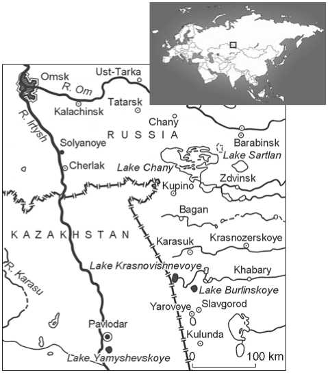
Fig. 1 . Map of the south of the Middle Irtysh basin.
At the beginning of the 18th century, several conflicting trends emerged in relation to the salt industry on Lake Yamyshevskoye. First, according to the decree of Peter I of September 9, 1701, it was supposed to significantly increase salt production “in order to replenish the treasury”. Second, in 1705, a state monopoly on the sale of salt was established in Russia, which led to its rise in price. Third, in 1707, a royal charter was sent from Moscow to Tobolsk, according to which “it is prohibited to go to Lake Yamyshevskoye on small boats for salt harvesting” (Polnoye sobraniye…, 1987: 355; Vaskov, 2020: 84).
In 1716, the formation of the Irtysh defense line began (Evseev, 1974; Muratova, 2007) (Fig. 2). With the advancement of the equipped Siberian border far to the south in the first two decades of the 18th century, Lake Yamyshevskoye, the main source of salt in the southwestern Siberia, happened to be located within the borders of the Russian State. In 1722, an imperial decree was issued on the regulation of the salt industry, which laid the foundations for the state monopoly on salt in Siberia. In the first quarter of the 18th century, fortification infrastructure of the Irtysh defense line was initially designed. In the register of Major General K.K. Kinderman, compiled in the autumn of 1745, the defense line was supposed to be equipped with signal beacons not only in the midway between various fortifications (fortress, outpost, redoubt, camp), but also at each fortification point. In this document, published by G.N. Potanin (1867: 15), the toponym Salt Turn is mentioned for the first time: a tract where a post station and a lighthouse should have been established. The Russian State Military Historical Archive contains the “Map of the Irtysh River from Omsk to Ust-Kamenogorsk Fortress. Composed in 1745” (RGVIA. F. 420, Inv. 1, D. 4) (Fig. 3). In its lower right corner, there is an autograph “Engineer Lieutenant Andrey Seliverstov”; on the back of the sheet, there is an entry: “According to general register No. 24. Sent upon a report from Major General K.K. Kinderman with Sergeant Sokolov on May 17, 746”. The “Register sent to the High Government Senate on the map of the Irtysh River and on its fortresses and redoubts”, signed by the same Andrei Seliverstov, lists the map, design plans for the redoubts and the lighthouse, “Inventory of the fortresses designated on the Irtysh River map”, an estimate, an opinion, and two statements (RGADA. F. 248, Inv. 113, D. 1584, fol. 619). Comparison of the inventory with the map from the RGVIA suggests that these belong to a single set of documents. The legend of this cartographic documentation indicated “where postal yards, defenses, lighthouses, and others were determined to be built”; and among them was the Salt Turn tract (Borodovsky, Chibyshev, 2021a: 29; 2021b). In the late 18th century, the Salt Turn was marked on several other maps. In particular, on a map “Peasant dwellings under the jurisdiction of the office of the Kolyvano-Voskresensky mining authorities, at what distance they are from factories and mines, and at what positions they are situated” of 1771 (RGIA. F. 485, Inv. 5, D. 478, fol. 1) and on the map “Kolyvano-Voskresensky factories and mines located in the Kolyvan governorate, composed from various special maps…” of 1794 (Ibid., D. 480, fol. 1). In 1771, Academician P.S. Pallas, who visited the Irtysh defense line, left a fairly detailed description of the Salt Turn (1786: 123, 124) and gave his explanation of the origin of this toponym: “The village of Solyanoi Povorot [Salt Turn] is so called, because in this location the wagons sent for salt from the Irtysh River to the Baraba steppe to the salt lakes of Vishnevoye and Karasukskoye… take a turn” (Ibid.: 125).
The establishment of the station, redoubt (stanets)*, and the village of Salt Turn, according to indirect data, can be attributed only to the first quarter of the 18th century (Borodovsky, Chibyshev, 2021a: 34). The assumptions that this fortified point existed in the initial period of the formation of the Irtysh defense line have not yet been evidenced by the documents. In 1771, the location of the Salt Turn village was described by Academician P.S. Pallas as follows: “The place preceding the village is rather low… there are two deep gullies (bueraks) that go from here to the Irtysh River” (1786: 123). The actual location of this fortified point was unknown for a long time, until in 1984 a school teacher P.V. Chibyshev from the Solyanoye village found on the right bank of the Irtysh, 1.2 km north-west of the Solyanoye village, a subrectangular area 100 × 70 m, enclosed by a ditch 1.2 m wide, up to 0.4 m deep (Fig. 4). It is located at the southern edge of the ravine Maly Log, which adjoins the bank edge of the Irtysh. Downstream the river, there is another ravine—Bolshoi Log. These ravines is correlated with the two gullies (bueraks) described by Pallas in the late 18th century (1786: 123), since the word buerak of Turkic origin means ‘ravine’ (Ozhegov, 1960: 126). The location of the enclosed area identified by P.V. Chibyshev is quite comparable with the description of the village of Salt Turn given by Pallas in 1771: “It [the village] lies on a small breakthrough of a high river
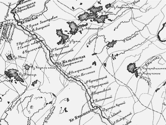
Fig. 2 . Map of the Irtysh defense line of the late 18th to early 19th centuries.
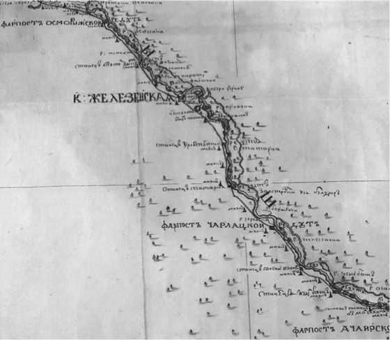
Fig. 3. Map of the Middle Irtysh basin in 1745.
bank… In this location, there are no islands on the Irtysh River. The bank rises from Solyanaya along with the steppe and is very steep” (1786: 123, 124). Tacheometric survey of this territory, carried out in the spring of 2021 by R.V. Davydov, made it possible to reveal a significant elevation difference from the side of the steppe to the bank edge of the Irtysh (Fig. 5).
The correctness of localization of the redoubt, stanets , and the village of Salt Turn can also be clarified by the “Description of the Tobolsk, Ishim, Tarsk, Irtysh, Kolyvan, Kuznetsk lines” dated 1785. In accordance with this document, the village of Salt Turn
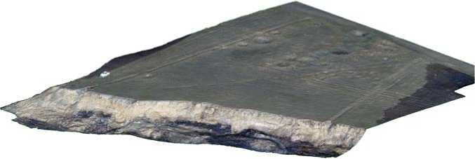
Fig. 4 . Orthophotomap of the Salt Turn redoubt (compiled by R.V. Davydov, S.A. Epler).
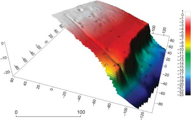
Fig. 5 . Plan of the Salt Turn redoubt based on the tachometric survey (compiled by R.V. Davydov).
was located at a distance of 18 versts (19.203 km) and 100 sazhens (220 m) up the Irtysh River from the stanets of Izylbashsky, and at a distance of 25 versts (26.670 km) and 300 sazhens (660 m) to the next outpost of Cherlakovsky (Muratova, 2013: 109). It should be noted that today the distance indicated in the geographical description of the Irtysh defense line from 1785 from the Salt Turn fortifications to the edge of the Irtysh River bank (15 sazhens (33 m) from the bank) (Ibid.) does not correspond to reality. As a result of bank erosion, the profiles of the ditches of the fortified area adjacent to the Irtysh River were exposed (Fig. 6, 7). Notably, written documents of the late 18th century already mentioned a significant erosion of the Irtysh bank near some defensive structures (Ibid.). Nevertheless, it was precisely this bank spatial distribution that was most characteristic of the typical redoubts of the Irtysh line (RGVIA. F. 418, Inv. 1, D. 936, fol. 1) (Laskovsky, 1866: Fol. 12, im. 14; Muratova, 2013: 112) (Fig. 8).
After localization of the Salt Turn redoubt according to historical sources of the 18th century, it is necessary to correlate modern archaeological data with this written evidence. In 1771, Pallas gave the following description: “This village, as also the one previously mentioned (Izylbashskaya), is not fortified…” (1786: 123). There is also no information about earth structures for a number of fortifications in the geographical description of the Irtysh line of 1785 (Muratova, 2013: 109). This fact can have different interpretations. First, the earth defensive structures of the Salt Turn redoubt may date back to an earlier period of its existence. It should be noted that in 1771 Pallas described in sufficient detail the earthen ditch of the Omsk fortress and the Uzko-Zaostrovskaya village (1786: 115, 117–119). Perhaps this was both due to the larger size of this fortification, and to its periodic renewal. The version about the earlier origin of the ditches of the Salt Turn redoubt is confirmed by their subtrapezoid profile, typical of the fortification of the early 18th century (Borodovsky, 2021: Fig. 1, 7; 2; 4, 2) (see Fig. 7, 8). Second, the lack of description of the earthen fortifications of many stanets, redoubts, and outposts of the Irtysh line from the Omsk fortress to the
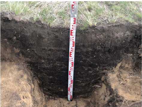
Fig. 6 . Profile of the northern ditch of the Salt Turn redoubt in the bank edge of the Irtysh ( photo by A.P. Borodovsky ).
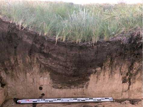
Fig. 7. Profile of the southern ditch of the Salt Turn redoubt in the bank edge of the Irtysh ( photo by A.P. Borodovsky ).
Cherlak outpost in 1771 and 1785 could be due to the fact that these had not been renovated for a long time, were not upgraded, and fell into disrepair (Pallas, 1786: 123; Muratova, 2013: 109, 110).
Salt-related toponymy in this territory was not accidental. It corresponds primarily to the tradition of the Tsardom of Muscovy to equip fortification points near salt mines and salt transport routes. For example, the letter missive to the Tara voivode I.V. Koltsov-Mosalsky, dated February 27, 1608, contains the following words: “And near the salt lakes up the Irtysh River, without a prison and without a fortress, there is no fortification for the Kolmak people” (Russko-mongolskiye otnosheniya…, 1959: 25).
The universal motivation for the use of words associated with salt as a topo-element was the fact that throughout the history, the economy of many Austrian, Dutch, Italian, German, Russian, Swiss and other settlements was based on the extraction, purification, and sale of salt. This is reflected in the semantic structure of many toponyms: these included words meaning salt from various languages (Gataullin, Fatykhova, 2018: 543–545). Notably however, in the salt-related toponymy, such an important logistic process as the transportation of salt was ignored. An example is the former name of the village Solyanoye of the Cherlaksky District, Omsk Region: Solyanoi Povorot (Salt Turn). This toponym is rather curious. First, it is unique in the territory of its location. Second, there is a transformation over time in the name of the settlement, which reflects the historical dynamics of transportation and harvesting of lake salt in the south of Western Siberia. Third, the interpretation of the meaning of such a toponym is ambiguous. The last point deserves special attention. First of all, it must be emphasized that from a geographical and historical point of view, the Irtysh River in its middle and upper reaches is the natural boundary of the southwestern Siberia. Therefore, it is no coincidence that in the 18th century it was here that
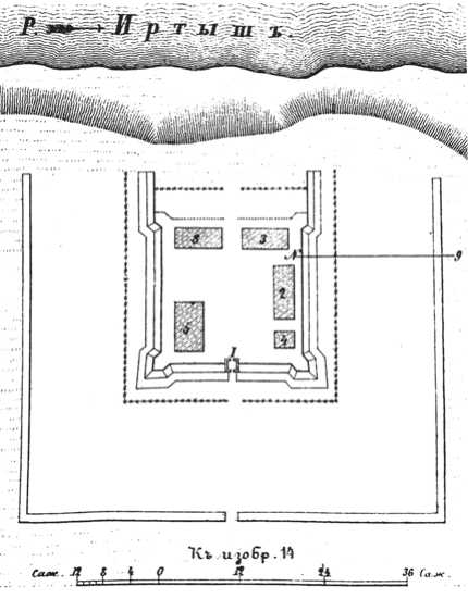
Fig. 8 . Plan of a typical redoubt on the Irtysh defense line (Laskovsky, 1866: Fol. 12, im. 14).
the Irtysh defense line began to form (Muratova, 2013), which was in use more than one and a half centuries. Another important thing was the transportation along the Irtysh River of the salt from Lake Yamyshevskoye. The presence of such “salt” logistics in the Middle Irtysh basin largely determined the appearance of the toponym Salt Turn (station, redoubt, village) (Borodovsky, Chibyshev, 2021a: 35). It should be emphasized that Pallas, who in 1771 gave the above explanation of this toponym, described in detail the salt industry in the south of Western Siberia in the 18th century (Vaskov, 2020). Consequently, he thoroughly investigated the salt industry in the region, and all his remarks regarding the organization of this production and also the logistics of the final product are extremely important. Of course, the toponym Salt Turn belongs to the widespread group of names of settlements on the so-called “salt roads”. They are known in many countries of Eurasia (Spain, France, Germany, Poland, Russia). However, the Pallas’s explanation of the origin of the toponym Salt Turn contains an important indication: this road didn’t serve to the most important salt deposit of that time—Lake Yamyshevskoye (from which the salt was delivered along the Irtysh), but to the salt lakes Vishnevoye and Karasuk, located 50 versts east of the main river (Pallas, 1786: 142–145). The salt in these lakes was of very high quality, but was deposited on the bottom in layers up to one cubit (48 cm) thick (Shostyin, 1975: 256).
Discussion
At present, the hydronyms mentioned by Pallas (1786: 125, 142–145) are localized as follows. In the south of the Ob-Irtysh interfluve, there is only one lake on the border of the Baraba forest-steppe and the Kulunda steppe with an accordant name: Krasnovishnevoye (Kipriyanova, 2020: 50, fig. 1, 57 ). Most likely, it is this that corresponds to one of the lakes described by Pallas (1786: 145) (see Fig. 1). However, this salt deposit was clearly not the main one. Therefore, it cannot be argued that such a “salt” road was a priority. The main transportation of salt was carried out by water. First, its main source, Lake Yamysh (now Tuzkala) was located only 5–6 versts from the Irtysh. This greatly simplified the transportation. The easiest way to get to the lake was to go up the Irtysh River on ships from Tobolsk past Tara. Also, the waterway provided the best protection from the unpredictable nomads. Second, the salt from Lake Yamyshevskoye was of high quality. However, periodically the thickness of the salt deposit was significantly reduced (or the reserves of the deposit were not restored), which probably required the use of other, lower quality salt deposits in Baraba. In fact, this was the “reserve” variant, which was probably used only episodically, and this was reflected in the singularity of the toponym Salt Turn for the area where it was localized (see Fig. 2, 3).
Long-term “salt” roads are characterized by the seriation of such toponyms. This version is indirectly confirmed by the geographical description of lakes where salt extraction is possible, in a book devoted to Western Siberia, which was published at the beginning of the last century (Rossiya, 1907: 343). Notably, Vishnevoye and Karasuk lakes are not mentioned in this book. In our opinion, this suggests the historical situatedness of the appearance of the toponym Salt Turn, which was associated only with a certain episode of salt logistics in southwestern Siberia. No less important is the fact that even in the publication of Pallas, there is a variability in the interpretation of the toponym associated with salt in the Middle Irtysh. At the beginning of the description of this settlement, he uses the name Solyanoi Povorot (Salt Turn) (Pallas, 1786: 125), while further in the text the name “Solyanoye” (Salt) occurs (Ibid.: 126). It is this “truncated” version of the toponym that has survived up to the present, having finally lost its connection with the “salt” road to the Baraba forest-steppe and Kulunda, which was used in the 18th century.
The presence of salt-related toponymy in the Middle Irtysh basin indirectly points to archaeological objects associated with extraction, storage, and use of salt in this region (Burchard, 1957). For the area under consideration, such a feature was noted as early as the late 18th century (Pallas, 1786: 126). In this regard, it should be noted that study of the salt issue with consideration to archaeology involved a certain algorithm that was formed back in the middle of the last century. The first stage of such work was the collection and generalization of data from medieval written sources, topographic data, as well as mapping of areas where salterns were supposed to be located in the past. The next stage included the localization of the salterns in specific areas on the basis of archival materials and archaeological surveys. The final stage was the purposeful large-scale archaeological studies in the most promising areas, for which there were written historical sources about salt extraction or transportation, geological data on salt deposits and their type, and archaeological materials related to salt industry (Burchard, 1957: 186). Judging by these features, it should be noted that a number of areas in southwestern Siberia are extremely promising for conducting such comprehensive studies. Salt works, which originally implied salt gathering, eventually led to the formation of an extractive industry in the West Siberian region.
Artifacts associated with salt
One of the artifacts associated with the use and storage of salt in the Middle Irtysh basin, found on the territory of the modern Solyanoye village, is a small ceramic vessel of a specific shape (Fig. 9). At the base of its conical body, there were three legs protruding in different directions, not more than 2 cm in size. The vessel was hand-made and well-fired. The total dimensions of the container were 10 × 8 cm; and it could hold up to 60 g of coarse salt. This amount of substance corresponds to shkalik (62 ml)—the traditional Russian measure of volume of liquids and bulk substances. By its size, the vessel most closely corresponds to salt shaker, since up to the present time dishes for salt are represented exclusively by small containers, from 6.5 × 6.8 × 6.5 to 10.0 × 10.5 × × 10.0 cm, intended for storage and serving of this product. The morphology of the item from Solyanoye—a conical body and three supporting legs—is very close to the traditional forms of ceramic dishes for salt. Such vessels of the Bronze Age are widely known in Western Europe (Burchard, 1957, 1959, 1963; Kostrzewski, 1968; Jodlowski, 1969, 1972, 1976) (Fig. 10). Three protruding legs at the base of the vessel from Solyanoye show a certain similarity to the ceramic supports used for salt-making tanks. Such items were widespread (from Britain to Italy) in the Late Bronze Age (Ibid.) (Fig. 10, 2–9). Despite such analogies, the relative dating of the ceramic vessel from Solyanoye is rather difficult and corresponds to the Bronze Age. Notably, in the vicinity of the village of Solyanoye and on its territory, there are quite a lot of different archaeological sites of that time. The first mention of such facts dates back to the late 18th century (Pallas, 1786: 130). In the middle of the last century, in the village of Solyanoye, a bronze dagger-acinaces of the Early Iron Age was discovered (Borodovsky, Chibyshev, 2021a: 9). However, regardless of its attribution to a certain chronological period of the Bronze Age, this ceramic vessel with a conical body on three legs is very close to the clay utensils associated with salt. This is what allows us to consider the artifact in the same historical context with written evidence and toponymy associated with the salt industry in the Middle Irtysh basin.
Conclusions
A comprehensive study and reconstruction of the history of the salt industry in the southwestern Siberia is quite relevant. The earliest evidence of systematic salt mining and transportation in Eurasia dates back to the Neolithic (Nenquin, 1961: 11, 158; Weller, 2004; Weller et al., 2009). Numerous high-quality natural salt deposits in the southwestern Siberia were a valuable and attractive resource of the region. On the territory of Poland, Romania, Hungary, Slovakia, and Western Ukraine, salt mining during the Bronze Age (Burchard, 1957, 1959, 1963; Kostrzewski, 1968; Jodlowski, 1969, 1972, 1976; Kadrow, Nowak-Wlodarczak, 2003; Przybyla, 2010; Dzi^gielewski, Szczerba, Chudzinska, 2011; Kavruk, Georgie, 2011, 2012) was a much more labor-intensive activity as compared to the southwestern Siberia.
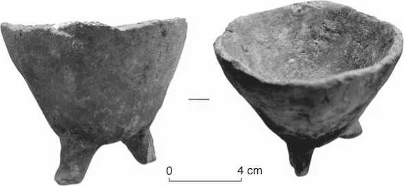
Fig. 9 . Ceramic vessel from the Solyanoye village (Cherlaksky District, Omsk Region), in the vicinity of the Salt Turn redoubt.
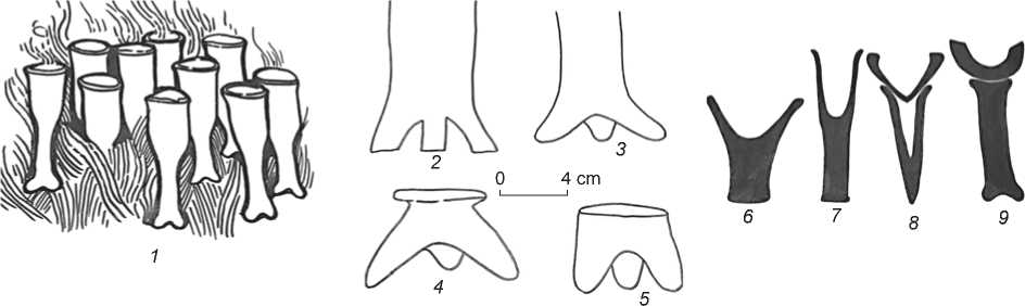
Fig. 10. Pottery associated with the salt industry of the Late Bronze Age and Early Iron Age, from Western Europe (after (Jodlowski, 1976: Rys. 20, 21)).
1 – reconstruction of the process of salt evaporation in conical vessels; 2–9 – forms of supports for conical vessels used in salt making.
In general, in the course of the archaeological study of “salt” issue, a certain algorithm for solving a number of problems has been developed: 1) formation of a source base of research; 2) establishment of chronological sequence of facts from the history of salt mining; 3) identification of archaeological materials serving as confirmation of data from written sources and vice versa; 4) attempts to synthesize new knowledge about the historical past, which in its final form is not present in any of the sources, and is not a simple set of data. Taking into account the very initial stage of the study of the historical past of the Siberian salt industry at the archaeological level, all these tasks are extremely relevant for further research involving the entire complex of geographical, geological, historical, toponymic, and archaeological data.
Acknowledgments
References “Salt turn”—a toponym in the Middle Irtysh basin: historical and archaeological evidence
- Borodovsky A.P. 2021 Sections of the early 18th century ditch at Fort Umrevinsky. Archaeology, Ethnology and Anthropology of Eurasia, vol. 49 (1): 94-100. DOI: 10.17746/1563-0110.2021.49.1.094-100 EDN: IYQIJQ
- Borodovsky A.P., Chibyshev P.V. 2021a Solyanoy Povorot na Srednem Irtyshe: Stantsiya, redut, stanitsa Irtyshskoy oboronitelnoy linii XVIII-XIX vv. Omsk, Novosibirsk: Apostrof.
- Borodovsky A.P., Chibyshev P.V. 2021b Khozyaistvennaya deyatelnost na Solyanom Povorote (mayak, stantsiya, redut) Irtyshskoy linii v XVIII veke. In Kultura russkikh v arkheologicheskikh issledovaniyakh: Arkheologiya Severa Rossii, vol. 2. Omsk, Surgut: Inst. arkheologii Severa, pp. 15-19. DOI: 10.18004/imt/2020.15.2.19 EDN: KFHMUM
- Burchard H. 1957 Z badan nad pocz,!tkami eksploatacji soli w Polsce. Sprawozdania Archeologiczne, vol. 4: 180-186.
- Burchard H. 1959 Eksploatacja soli w Polsce od XIII wieku. Slavia Antiqua, vol. 6: 396-412.
