Sections of the early 18th century ditch at fort Umrevinsky

Author: Borodovsky A.P.
Journal: Archaeology, Ethnology & Anthropology of Eurasia @journal-aeae-en
Section: The metal ages and medieval period
Article in issue: 1 т.49, 2021.
Free access
Short address: https://sciup.org/145146235
IDR: 145146235
Text of the review article Sections of the early 18th century ditch at fort Umrevinsky
The time of Peter the Great (1686–1725) in Russia was distinguished by extremely uneven distribution of the European principles of fortification. In the early 18th century, in southwestern Siberia, including the Upper Ob region, the principles of fortification of the Tsardom of Muscovy still dominated in the construction of earthen fortifications in forts, including Fort (Ostrog) Umrevinsky. It was built in 1703 by settlers from Fort Urtamsky on the right bank of the Ob River, slightly upstream from the mouth of its tributary, the Umreva River (Shunkov, 1956: 66, 67; Emelyanov, 1981: 131). The subsequent long existence of Fort Umrevinsky and its repeated reconstruction throughout the 18th century resulted in problems with identifying the original earthen fortifications (ditches) in the course of archaeological research. Solving these problems was the main goal and objectives of this study, aimed at locating the earliest sections of the ditch, conducting their relative dating, and analyzing the reasons behind the specific features in construction and functioning of earth fortifications. Studying these elements in the fortification of Siberian forts can make it possible to identify the historical dynamics of interaction between various fortification traditions during the construction of these border points of the Tsardom of Muscovy in Peter I era.
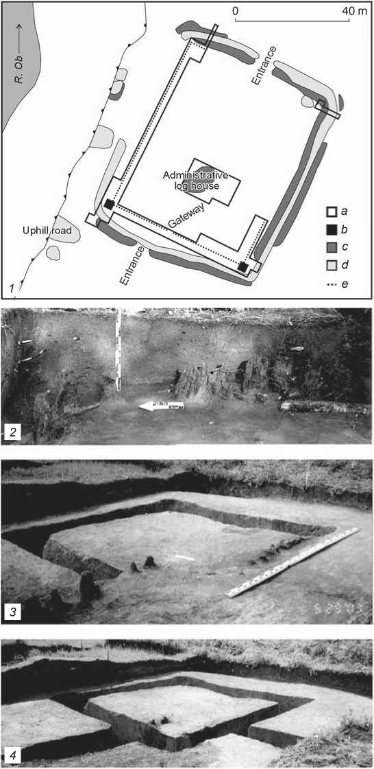
Identification of the parts of the early ditch at Fort Umrevinsky
During the field research in 2002–2018, it was possible to identify the corners of the southwestern ditch (Fig. 1, 1), which most likely remained from the early 18th century. Their archaeological study was carried out in depth. First, the configuration of corners in defensive structures as the most effective firing points fully reflects the features of fortification traditions of the time. Second, owing to a number of factors, parts of ditches have survived in their original form precisely in these areas. Third, the foundations of the later corner wooden defensive towers were found at the corners. The location of the towers relative to the early ditches reflects the sequence of construction periods, as well as innovations in fortification methods (Fig. 1, 1, 3, 4).
Change of the ditch configuration
Fig. 1 . The explored parts of fortifications at Fort Umrevinsky.
1 – fort planigraphy; 2 – eastern corner of the palisade; 3 – southwestern corner of the palisade under the girder-post foundation of the later tower; 4 – girderpost foundation of the southeastern corner tower; 5 – section of the changing configuration of the ditch;
6 – profile of the graveyard ditch in the interior area of the fort; 7 – preserved southeastern corner section of the fort ditch of the early 18th century.
a – excavation pit; b – tower; c – embankment, hill; d – ditch, pit; e – palisade.
According to stratigraphic observations in different parts of the fortification corners, discharged soil from the ditch did not cover the palisade ditch and palisade poles. An important fact was the presence of the foundation coin (denga of 1730), laid with its head up on the foundation of one of the corners in the girder-post foundation of the southwestern tower. The date minted on this coin correlates well not only with the frequency of repairing wooden structures (on average 29 years) (Varfolomeev, Shapovalova, 1991), but also with the renewal of Fort Umrevinsky, the need for which was indirectly mentioned in the written sources of the first third of the 18th century (State Archive of the Novosibirsk Region. F. D-105, Inv. 1, D. 6; see also (Messerschmidt, 1962: 78–79;
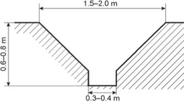
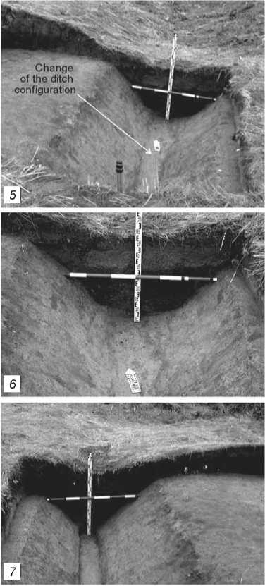
Fig. 2 . Diagram of the cross-section of the ditch from the early 18th century in the southwestern corner part.
Romanov, 2019)). Decay of palisade walls in other forts was also mentioned in this period (S.P. Krasheninnikov…, 1966: 51; Gmelin, 1751: 301).
The southwestern corner of the ditch, excavated in 2002–2003, had a specific sub-trapezoidal profile with a deepening at the bottom (Fig. 2). The width of the ditch in the upper part was 1.5–2.0 m; the width gradually decreased towards its base to 0.35–0.40 m. The total depth was 0.6–0.8 m. Traces of intense burning were found in the stratigraphic cross-section of this part of the ditch (Fig. 3, 1 ) (Borodovsky, Gorokhov, 2008: 73, fig. 5), which could have been caused both by anthropogenic factors and natural events. Such traces have been archaeologically observed in a number of Siberian forts (Bratsky, Albazinsky, Kazymsky, and Tobolsky). Another major extensive and powerful calcined spot was located near the girder-post foundation of the tower facing the river bank (Fig. 3, 1 ).
A different stratigraphic situation was discovered at the opposite, southeastern corner of the earthen fortifications at Fort Umrevinsky (see Fig. 1, 1 , 5–7 ). Two cross-sections of the ditch in this area (Fig. 4) reflected different periods of its construction and subsequent renovation. In its lower part, the filling of the ditch consisted of yellow loam interspersed with humus. It emerged from natural sliding of loam from the slopes into the ditch and its mixing with the sod layer, which
аb ■ c1
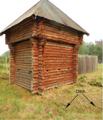
Fig. 3 . Planigraphy of the southwestern corner of the timber-earthen fortifications ( 1 ) and the restored corner tower of the fort facing the river bank ( 2 ).
a – ditch of the palisade and tower foundation; b – traces of burning; c – wooden posts and slabs.
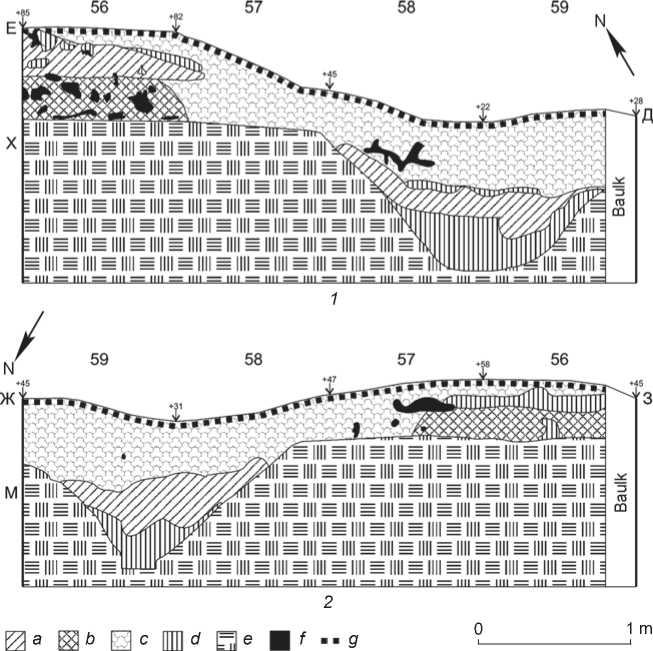
Fig. 4 . Stratigraphic cross-sections of the graveyard ditch ( 1 ) and fort ditch of the early 18th century ( 2 ). a – homogeneous mixture of humus and clay; b – dark gray humus; c – light gray humus; d – yellow clay interspersed with black humus; e – dark yellow clay (sterile surface); f – rootstalks; g – sod.
was formed on the surface of the ditch and embankment. The profiles of the ditch in two opposite sections differed significantly (Fig. 4). The profile was cup-shaped in the cross-section along the northern wall (see Fig. 1, 5 , 6 ; 4, 1 ), but was sub-trapezoidal with a small deepening at the bottom along the southern wall (see Fig. 1, 7 ; 4, 2 ) of the excavation pit. This part of the southeastern ditch was similar in size and profile to its southwestern corner (see Fig. 2). Such changes in parameters and outlines of the southeastern corner of the ditch might have occurred when it was deepened. This was needed for setting up the fence of the rural graveyard on the territory of the fort, which no longer existed since the turn of the 18th–19th centuries.
Discussion of the research results
In the 17th–18th centuries, fortification ditches in the European “Vauban” tradition were built according to pre-selected profiles (Vauban, 1744: 13). The presence of a small deepening in the base of the ditch at Fort Umrevinsky is notable, since the size of this element suggests that it resulted from the use of some type of earth-moving device.
Small “cut-off” iron shovels were of particular importance as entrenching tools of the 18th century intended for constructing earthen fortifications. They had sockets into which wooden handles were inserted. Fortification literature specifically mentions the mass of these earth-moving tools, which was 4–5 pounds (Ibid.: 18, 19). Given that the pound in Russia in the 18th century corresponded to 409.5 g (Shostyin, 1975: 258), the mass of the iron shovels could have ranged from 1638 to 2047.5 g. Notably, the working part of a small “cut-off” iron shovel was accidentally found in the vicinity of Fort Umrevinsky. In its design and mass, it was similar to the above-mentioned earth-moving tools of the 18th century. This makes it possible to suggest the possibility of having used such earth-moving tools in constructing ditches at Fort Umrevinsky in the early 18th century.
According to the present-day geological descriptions, soils in this area mainly consist of aeolian-deluvial loams distinguished by a not very high bearing capacity (Raiony…, 1996: 327). However, in the case of a relatively shallow ditch of the early 18th century, such soil relatively well preserved the original profile of the ditch until its subsequent later filling. At the southwestern corner of the ditch, this process was almost instantaneous after the fire.
Comparison of the main characteristics of a ditch of the early 18th century with the standards of the previous 17th century (Ustav…, 1777: 121–125) demonstrates some differences in basic proportions, sizes, and depth. In the first quarter of the 17th century, difference in the width of the ditch on top and at the bottom was not so significant, and the depth was almost one third of the width along the upper edge. Steepness of walls in ditches was also greater with the ratio of the width of a ditch at its top to its bottom varying from 3 : 1 to 6 : 1 (Shor, 1958: 27).
Subsequently (the 1730s), construction of two corner towers on the southeastern side of the palisade defenses at Fort Umrevinsky led to significant changes in the original fortification (see Fig. 1, 1 ). First, the corner towers protruding beyond the palisade wall received the function of bastions (see Fig. 1, 1 ; 3). Such a fortification solution resulted in significant increase in fire sectors. Second, the distance from the corners of the southeastern defensive structures to the outer ditch, which was built in the early 18th century, decreased over four times. Proximity of the girder-post foundations of the towers to the corner sections of the ditch is one of the signs of various construction periods in the history of Fort Umrevinsky.
Thus, it can be concluded that the southeastern part of the timber-earthen fortifications acquired its “bastion” appearance only by the first third of the 18th century. However, these improvements were not reflected in the original outline of the ditch. The traditional wooden towers, widespread in Siberia from the late 17th to mid 18th century (Borodovsky, Gorokhov, 2008: 78; Gorokhov, 2020), were built on girder-post foundations instead of European corner elements of fortifications (bastions) (see Fig. 3, 2), whereas judging by the second “version” of the existence of Fort Albazinsky (1685– 1686), bastion-type ditches were built in the Amur region already in the late 17th century (Albazinsky ostrog…, 2019: 177; 179, fig. 2.4.8; 191, 192). Reliable information on the appearance of bastions in the Eastern European part of the Tsardom of Muscovy refers to the late 16th century (Nosov, 2002: 101). Construction of European-type bastions in southwestern Siberia is known from the early 18th century (the old Omsk fortress) (Borodaev, Kontev, 2015: 170–172), while the “bastion” placement of corner towers in the combined system of Old Russian and European fortification traditions can be clearly seen in the planigraphy of the stone Gostiny Dvor (indoor market complex) of the Tobolsk Kremlin, built by S.U. Remezov at the early time of Peter’s reign (Kirillov, 1974: 63). Such facts clearly demonstrate the extreme unevenness in the spread of the European principles of fortification in Peter’s time over Siberia as a whole. It is equally important that subsequently, throughout the 18th century, the distinctive feature of Siberian border fortified lines was a harmonious combination of the latest achievements of Western European fortification with the Russian experience of building defensive structures (Muratova, 2007: 113). This process is rather consistently manifested by the example of Fort Umrevinsky.
The first construction period (the early 18th century) corresponded to the appearance of a sub-rectangular wooden defensive structure made of round palisade posts in 1703. Its expressed geometric outline agrees well with recommendations for constructing and planning fortifications, presented by A. Radyshevsky as far back as the 17th century (Nosov, 2002: 168). As opposed to the right angles of the palisade fence at Fort Umrevinsky (see Fig. 1, 2 , 3 ), the corners of its ditches in these areas were rounded (see Fig. 1, 1 ; 3, 1 ). The distance from the corners of the wooden defensive structure to the inner edge of the ditch was more than 1.7 m, which corresponds to a makhovaya sazhen (1.78 m), and reached 6 m from the southeastern wall (Shostyin, 1975: 256, 259).
The second construction period (first half of the 18th century) is associated with the functioning of Fort Umrevinsky as a defensive, administrative, and religious center in the north of the Upper Ob region. At that time, two corner towers and an administrative log house were built (see Fig. 1, 1 , 3 , 4 ; 3). The distance from the corners of the foundations of the towers to the inner edge of the ditch was 0.4 m. This is closest to such a measure of length as the cubit, which was already an archaism for the 18th century (Ibid.: 256). Traces of periodic cleaning of the ditch have not been stratigraphically found in its explored sections. Such a procedure was necessary for the long-term functioning of ditches (Svistun, 2016: 369). The absence of traces remaining from cleaning the ditch can be explained both by its shallow depth and by the relative density of the soil in which it was dug. It was experimentally established that the inclined walls of such a ditch naturally acquired an original sod layer already seven years after they were unearthed by the excavations (Borodovsky, Gorokhov, 2008: 73).
The third and final construction period (late 18th to early 19th centuries) corresponds to the time when Fort Umrevinsky lost its importance; its wooden defensive structures decayed, and the main area turned into a graveyard. According to written sources, fortifications in the Novosibirsk Ob region underwent the process of destruction in the last third of the 18th century. For example, in 1773, Fort Chaussky lost its fortifications (Pallas, 1788: 7); in 1791, the defensive structures of Fort Berdsky were dismantled and sold (Minenko, 1990: 32). In 1794, Fort Umrevinsky disappeared from the maps of the Kolyvan-Voskresensk district for the first time (Russian State Historical Archive. F. 485, Inv. 5, D. 480, fol. 1). Not earlier than this time, judging by the archaeological evidence, the deepened ditch, which acquired a bowl- shaped profile (see Fig. 1, 5, 6; 4, 1), became an earthen border of the Umrevinsky graveyard. Embankments were formed on the outer and inner sides of the ditch. In some areas, the embankment covered the trench of the fort palisade with the already disappeared posts, but the corners of the early ditch of Fort Umrevinsky remained free, which contributed to preservation of their original appearance, as also did the possible presence of later, deteriorating corner towers in these areas.
Conclusions
The construction of Fort Umrevinsky in the north of the Upper Ob region was a part of the tremendous project of building fortifications over the vast Siberian territories of the Tsardom of Muscovy at the turn of the 17th–18th centuries (Ocherki…, 1979: 284). Uneven distribution of the European principles of fortification continued to be a distinctive local aspect of that period. It would seem that the date when Fort Umrevinsky was built (1703) correlates with the time of large-scale introduction of this military engineering phenomenon in Russia, associated with Peter I era (Kostochkin, 1962: 7; Maloletko A.A., Maloletko A.M., 2001: 89). However, precedents of an integrated combination of earlier defensive structures (Shlisselburg-Oreshek) with fortifications (bastions) of the early time of Peter’s reign (1702–1703) are known from the westernmost boundaries of the Russian State (Iogansen, Kirpichnikov, 1974: 30, 46). In many ways, the forerunner of this phenomenon was the spread of the bastion system to the northwestern borders of the Tsardom of Muscovy long before the beginning of the 18th century, since the first timber-earth forts with bastions apparently appeared there from the second half of the 16th to the first quarter of the 17th century (Nosov, 2002: 60, 118). At the same time, in Siberia and the Far East in the 17th century, construction of sub-rectangular defensive structures surrounded by a ditch around the perimeter continued. However, in the late 17th century, during the restoration of Fort Albazinsky on the Amur River in 1686, a different (“Italian”) fortification technique of the bastion type was followed (Artemiev, 1999: 7; Albazinsky ostrog…, 2019: 176). The outer ditches duplicated all protrusions of the corner bastions. In southwestern Siberia, such a fortification technique was first used for Fort Kashtatsky, which functioned from 1697 to 1703.
Such facts are of particular importance for Fort Umrevinsky primarily because its “parent fort” was Fort Urtamsky built in 1684. It should be emphasized that both forts were built upon official decrees and had a geometric layout of fortifications, whereas judging by the written sources, the palisade walls of Forts Mungatsky and Berdsky, built in 1715–1716, were oval in outline (Miller, 1996: 24). The reason for this unique layout, most likely, was that the latter defensive structures were built not upon decree from the center, but by the decision of the local authorities (Borodaev, Kontev, 2015: 186, 189). Notably, the bastion principle of fortification, successfully tested in Fort Kashtatsky, was implemented in Fort Umrevinsky only after building the girder-post foundations of the corner towers on its southern side in the 1730s.
On the basis of the above facts, the ditch of Fort Umrevinsky of the early 18th century should be considered to be a result of the previous development of Russian defense architecture in Peter I era. The earthen and wooden structures of this fortified site reflect the final stage of the “Old Russian” fortification tradition in Siberia, which was developed on the southern borders of Russia in the 10th–13th centuries (Morgunov, 2009: 241–250). This tradition of building timber-earthen defensive structures obviously experienced a certain influence of foreign fortification principles as far back as in the pre-Peter period.
Establishing construction periods for ditches in each of the Siberian fortifications that existed in the 18th century is of particular importance for reconstructing the historical pace of the development of the principles of European fortification in Peter’s time in Siberia. Their archaeological identification makes it possible to establish unevenness in the distribution of features of European fortification over the vast Siberian spaces with more precision. Influence of foreign fortification experience for Fort Umrevinsky can be assessed as indirect and significantly “stretched out” in time (almost the entire first third of the 18th century).
Acknowledgment
This study was supported by the Russian Foundation for Basic Research, Project No. 20-09-42058/20.
