Spatial Analysis of the Transformation of the Arkhangelsk Industrial Zone

Author: Potapov I.A., Erokhin V.L.
Journal: Arctic and North @arctic-and-north
Section: Social and economic development
Article in issue: 60, 2025.
Free access
The transformation of industrial zones in cities during the transition of economy to post-industrial development is reflected in the emergence of abandoned industrial areas on the sites of closed inefficient enterprises. At the same time, the city budget ceases to receive taxes from these areas. For a more rational use of such lands, their revitalization and renovation are necessary. The problem of using former industrial zones is typical for all cities in the Arctic. Using Arkhangelsk as an example, a retrospective analysis of the formation and transformation of its industrial zone was conducted. It does not represent a continuous space, but is located separately in several parts of the city. Based on the peculiarities of the geographical location and specialization of production, three industrial areas have been identified: Northern, Central and Southern. Analysis of the public cadastral map has determined the current state of the industrial territories of enterprises that existed in Arkhangelsk during the Soviet period. It was revealed that most of the closed enterprises are located in districts with poor transport accessibility in the northern area on island territories and partially in the southern area. These are mainly enterprises of the timber industry complex. This process contributed to the degradation of the outskirts of Arkhangelsk, especially on the island territories. At the same time, most of the remaining timber industry enterprises are located in the central part of the northern area, near the main highway connecting it to the city center and the seaport. This area is the most promising for the revitalization of production. The central industrial area has undergone the least transformation. Here, residential construction is taking place on the site of industrial sites, and public and business spaces are being created. In the southern industrial area, there are promising territories for the creation of logistics zones (the port areas of Zharovikha, Bakaritsa, and Levy Bereg). Former industrial zones on island territories can be used to create landscape parks and to develop recreation.
Transformation, industrial zone, timber industry, Arctic cities, Arkhangelsk
Short address: https://sciup.org/148331891
IDR: 148331891 | UDC: [711.554:330.341](470.11)(045) | DOI: 10.37482/issn2221-2698.2025.60.81
Text of the scientific article Spatial Analysis of the Transformation of the Arkhangelsk Industrial Zone
DOI:
The transition to post-industrial economic development, the obsolescence of many industrial facilities, and changes in market conditions are leading to the closure of unprofitable enterprises. This results in industrial zones in cities becoming no longer in demand for their intended purpose, and local budgets receive virtually no tax revenue from these territories. As a result, urban land is used inefficiently [1, Mirolyubova T.V., Nikolaev R.S.; 2, Tolpinskaya T.P., Alzemeneva E.V., Mamaeva Yu.V.; 3, Khramtsov A.B., Poroshin O.S.]. This is particularly relevant for old industrial cities, where, as urban boundaries expand, industrial zones initially established on the out-
∗ © Potapov I.A., Erokhin V.L., 2025
SOCIAL AND ECONOMIC DEVELOPMENT
Igor A. Potapov, Vasiliy L. Erokhin. Spatial Analysis of the Transformation … skirts are now located in the center. As a result, “grey belts” of abandoned urban land emerge, and the urban landscape becomes uneven.
The problem of unused industrial areas is characteristic of all Arctic cities. In the Russian Arctic, urban settlements were established during the Soviet industrialization period around extractive and manufacturing enterprises. After the depletion of mineral resources and the closure of enterprises, abandoned industrial areas appeared. Urban boundaries, however, remained unchanged. Cities then rapidly declined and began to shrink. The reasons for the population outflow from Arctic territories are linked to the socio-economic restructuring of the city-forming enterprises of northern cities that began at the end of the last century, followed by their subsequent closure [4, Nedoseka E.V., Sharova E.N., Shorokhov D.M.]. Arkhangelsk is an example of such an Arctic city, which experienced its most rapid growth during the Soviet industrialization period, while the crisis affecting most industrial enterprises was linked to the depletion of necessary available resources.
A pressing issue for the further development of Arctic cities is the rational organization of urban systems using a spatial-economic approach. The repurposing and renovation of former urban industrial zones revitalizes such cities, making them more attractive for investment and living, thereby slowing down their degradation.
The aim of our research is to conduct a spatial analysis of development of the industrial zone of Arkhangelsk and to identify possible directions for its renovation based on international experience and local conditions.
Research materials and methods
Numerous scientific works are devoted to the problems of the transformation of postindustrial cities around the world. The transformation of their industrial zones is considered in terms of the potential for revitalization and renovation. The essence of these concepts is almost the same and means defining new functions or restarting old ones in unused industrial areas of the city. Residential buildings, public and business areas, and recreational public spaces may appear on the site of former industrial zones [3; 5, Beauregard R.A.; 6, Sykora L., Bouzarovski S].
Renovation involves the partial or complete renewal of structures, their functions and purpose [2]. This may involve the demolition of existing production facilities, changes in their functions or the preservation of enterprises, but their buildings can be used for new purposes [7, Shukurov I.S., Morozov D.N.; 8, Grishechkina I.E., Isakova E.V.]. Renovation most often takes place in obsolete industrial areas. An analysis of global experience in the transformation of urban industrial zones shows that significant areas of them have begun to perform service functions rather than industrial ones. Recreational spaces, tourist attractions, and public spaces for city residents are particularly common there [1; 3; 9, Chernyshova N.A.; 10, Gorodetskaya A.S.; 11, Balabanova Yu.P., Budkevich N.M.; 12, Harfst J., Sandriester J., Fischer W.]. In cities with a long history of industrial development, where industrial complexes were built in the best architectural traditions of their time, industrial architectural ensembles are being restored and revitalized. They are being converted into museums, restaurants, offices and residential apartments.
One option for revitalization is to create green areas and landscape parks on former industrial sites or to develop environmentally-oriented activities there (recycling centers, eco-industrial parks, green technology centers). Another important area of industrial zone revitalization is the creation of technological clusters, high-tech centers, business incubators for high-tech companies, and transport hubs on the sites of obsolete production facilities. Combined with measures to improve the environmental situation, these developments make the urban environment more comfortable to live in. Such centers are being created in cooperation with local universities and research institutions. These cases include Pittsburgh (USA), Malmö (Sweden), and other cities [10, Gorodetskaya A.S.; 11, Balabanova Yu.P., Budkevich]. An option for preserving existing production facilities is to “displace” them to the suburbs or to less developed regions with lower land rents, while the industrial zones freed up in the city undergo environmental rehabilitation and are used for new purposes. Since competition is taken into account when choosing the possible uses of urban land, the most profitable sites are allocated to those activities that offer higher rents [1]. If industrial zones cannot be used for recreational purposes, or if industrial buildings lack historical value and cannot be adapted for new production, public, or residential buildings, they are removed and the vacated spaces are transferred to new development. In any case, approaches to the revitalization of former industrial zones in cities are individual. It should be noted that transport accessibility can lead to more intensive use of industrial zones [9].
In recent years, researchers have increasingly focused on the population decline, degradation, and shrinking urban space in Arctic cities. The article by E.V. Antonov, E.A. Denisov, V.A. Efremova, and A.M. Faddeev examines the problems of shrinking cities in the northeast of the Komi Republic. In their study of Vorkuta, they note that after the closure of many coal mines and the relocation of the population from the settlements that were created around them, the “withering away of the urban periphery” began, while the healthy central core of the city stands out as its promising part. In Inta, due to the development of intra-city transport, which preserves the spatial structure of the city, the withering away of the periphery does not occur; the settlements created near the mines are preserved alongside the urban core. The researchers explain the process of decline of northern cities by the artificially stimulated growth of industries highly susceptible to market conditions in the 1930s [13].
Over the past 30 years, Arkhangelsk has been undergoing changes in its internal space associated with the mass closure of enterprises in the forestry complex, its primary industry. This has led to the city’s shrinkage and transformation. This process has particularly affected industrial zones and the associated workers’ settlements near sawmills on the city’s outskirts. Currently, the territories of many former enterprises remain abandoned, primarily those located on the islands of the city (Kegostrov, Khabarka, Brevennik). Against the backdrop of the general outflow of population from Arkhangelsk, residents of working-class suburbs are moving to more prosperous areas of the city or beyond its limits whenever possible. The population of Arkhangelsk decreased by 27.6% between 1989 and 2020. The population loss was particularly significant in the settlements of closed timber mills (in the Maimaksanskiy, Severny, Oktyabrskiy, Isakogorskiy, and Tsiglomen-skiy administrative districts). The population of island settlements without bridges decreased by approximately 70% from 1991 to 2022 [14, Potapov I.A.].
We studied the transformation of Arkhangelsk’s industrial zone using a comparative historical method. We determined the locations of enterprises that made up the city’s industrial zone during the Soviet period using addresses from the 1988 Arkhangelsk city telephone directory 1. We studied the current state of their industrial areas using the public cadastral map of Rosreestr and freely available satellite images 2. This allowed us to identify changes in the composition of the city’s industrial zones. The cadastral map makes it possible to determine the territories occupied by industrial enterprises, those that have lost their use, as well as areas allocated for the construction of enterprises but not used. The information component of the map contains data on the purpose and area of industrial territories. No information is provided on land plots that have not undergone the land-marking procedure, including the territories of some former enterprises. To study the spatial differentiation of the Arkhangelsk industrial zone and determine the prospects for its further development, we used a comparative geographical method and a zoning method. We divided the industrial zone of Arkhangelsk into areas based on differences in their transport and geographical location, the history of their emergence, the specialization of their core industries, and the administrative and territorial division of the city.
We studied the dynamics of the city’s industrial complex based on its efficiency in terms of land use. To do this, we calculated the economic return per unit of area of the industrial zone over four years using official statistics [1]. Directly on site, we used the method of participatory observation to identify the current state of the city’s industrial zones.
Each area of the industrial zone requires an individual approach to renovation.
Results and discussion
The unique geographic location of Arkhangelsk at the mouth of the Northern Dvina River determined its economic specialization. The city was conceived as a port, which implied the development of shipbuilding and ship repair. The city’s location at the mouth of the Northern Dvina, which flows through vast areas of pine forests, stimulated the creation of numerous sawmills, which receive raw materials by water. The formation of Arkhangelsk industrial zone began in 1693, when Tsar Peter the Great founded a shipyard on Solombala Island, based on the small private shipyards that existed there. In 1863, this territory became part of Arkhangelsk. Currently, it hosts the city’s oldest operating industrial zone, used for its original purpose (the territories of the Krasnaya Kuznitsa Ship Repair Yard and the Ship Repair Yard No. 176). The industrial zone near sawmills began to form after the advent of mechanized production and increased labor productivity. Subsequently, the development of the industrial zone of Arkhangelsk received the greatest acceleration in its entire history. The layout of sawmills, formed in the 19th century, became the basis of the industrial zone of Arkhangelsk during the Soviet period. “All sawmills were located on the riverbank, since raw materials were delivered to them by water, and finished products were exported by sea transport. A settlement for workers was created at each sawmill. These workers’ settlements with factories were incorporated into the city limits in the 1930s, already under Soviet rule. By 1928, about 30 sawmills were operating in Arkhangelsk, the majority of which were founded before 1917” [14, Potapov I.A., p. 30]. Some of the factories ceased to exist over time; some of them, located nearby, were combined into sawmills and wood processing plants (WPP), while others were used for the creation of timber storages. Of the 14 sawmills and wood processing enterprises operating in 1988, only 4 remained in operation in 2024. Sawmills were numbered during the Soviet era. The numbers increased downstream along the Northern Dvina River, and they remained in local toponymy as the names of the settlements built around them. A distinctive feature of the Arkhangelsk industrial zone is its fragmentation. In spatial terms, based on geographical location and industrial specialization, northern, central, and southern industrial areas can be distinguished (Fig. 1). The oldest areas emerged in the northern and southern parts of the city. Subsequently, the industrial zone expanded with the emergence of new industries, separate districts, and industrial hubs (Kuznechevskiy and Zharovihinskiy hubs on the right bank of the city).
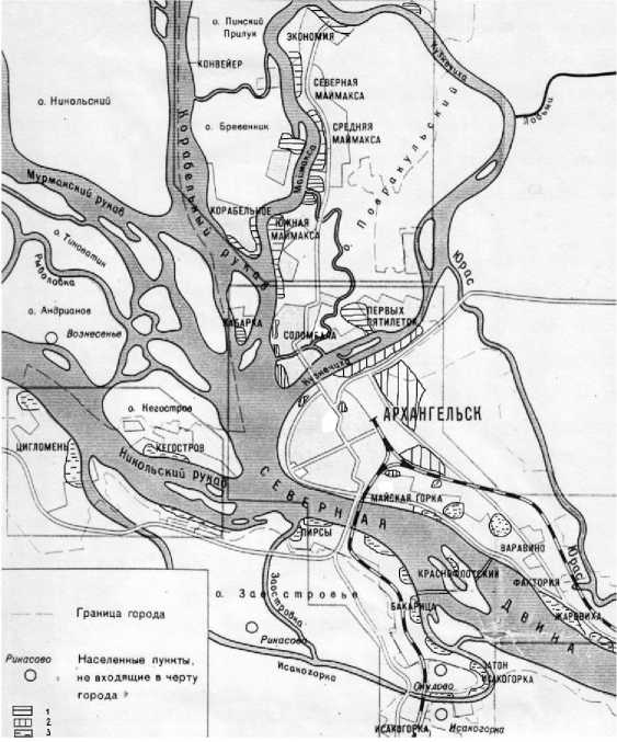
Fig. 1. Industrial areas of Arkhangelsk. The numbers in the figure indicate the areas: 1 — Northern; 2 — Central; 3 — Southern.
Overall, by the end of the 20th century, the industrial zone of Arkhangelsk occupied an area of 3,194 hectares, which is 10.8% of the city’s total area 3. If we consider the industrial zone together with the areas occupied by engineering infrastructure, its share of the city’s area increases to 17.9%. This is roughly in line with the figures for Russia’s largest industrial cities (in Moscow, the share of the industrial zone is more than 17%, in St. Petersburg – 13–14%, in Yekaterinburg – 16%, and in Perm – 10%) [1]. However, according to European standards, this share should not exceed 5%, which indicates a transition to a post-industrial economy [15, Mavlyutov R.R., Lukyanitsa M.V., Chizho L.N.]. The territorial distribution of the industrial zone by areas and administrative districts of the city is presented in Table 1.
Table 1
Distribution of the industrial zone across the territory of Arkhangelsk
|
Industrial area |
Urban district |
Industrial zone area (% of total urban) |
Modern core production |
|
Northern |
Maymaksanskiy |
25.9 |
Sawmill No. 25, LLC Cardinal, commercial port, repair and maintenance base for the trawler fleet |
|
Severny |
8.4 |
Wastewater treatment facilities of the SPPM |
|
|
Central |
Solombalskiy |
8.2 |
Ship repair plants No. 176 and Krasnaya Kuznitsa, Solombala machine-building plant, bakery |
|
Oktyabrskiy |
12 |
Kuznechevskiy industrial hub (numerous production and warehouse zones), TPP, building construction materials plant, ALVIZ plant |
|
|
Lomonosovskiy |
4.2 |
MUE "City Improvement" |
|
|
Southern right-bank |
Mayskaya Gorka |
13.4 |
Dairy plant, Sawmill No. 3 |
|
Varavino-Faktoriya |
9.95 |
Fish processing plant, seaweed processing plant, trawler fleet repair and maintenance base, Zharovihinskiy industrial hub, river port |
|
|
Southern left-bank |
Tsiglomenskiy |
4.97 |
Sawmill No. 25 |
|
Isakogorskiy |
12.8 |
Fleet repair and maintenance base, woodworking plant, Ba-karitsa cargo area, production and warehouse areas |
The number of operating enterprises in each industrial zone has currently declined, and their territories are largely abandoned. Some areas allocated for industrial sites have never been used for their intended purpose. Currently, these vast areas are overgrown with trees and can only conditionally be classified as industrial zones. According to V.G. Bondur and V.E. Vorobyov, who studied satellite images of Arkhangelsk from 2001 to 2013, the area of landscapes altered by economic activity has decreased by 900 hectares [16].
Let us consider each industrial area within the Arkhangelsk production zone. The Northern industrial area is located on the islands of the Northern Dvina River delta, north of the city center
(it includes the Maimaksanskiy, Severny, and partially Solombalskiy territorial districts). These districts became part of the city in Soviet times; the creation, development, and operation of the workers’ settlements were directly linked to the development of the factories. A distinctive feature of this area is the challenging transportation and geographic location of some island territories (Brevennik, Linskiy Priluk, Khabarka), which are not connected by bridges to the right-bank part of the city. The main industrial specialization of this area is the timber industry. The Arkhangelsk sawmill industry originated here. Therefore, most of its industrial areas are located in succession: the timber mills and timber storages of Maimaksa, Brevennik, Linskiy Priluk, Khabarka, and Pervykh Pyatiletok district (sawmills Nos. 12–29, Solombala WPP). The main part of the area, Maimaksa and Pervykh Pyatiletok district, are connected to the right-bank part of the city by bridges (highway and rail). Initially, the largest enterprises in the area included the Maimaksa WPP (including sawmills Nos. 13 and 14), Sawmill No. 25, Sawmill No. 3, the Solombala WPP, a hydrolysis plant, the Solombala PPM, the Lesosplavmash plant, and a fleet repair base. Currently, the only operating enterprise is Sawmill No. 25, which has incorporated the production facilities of Sawmill No. 3 and the Maimaksa WPP (as well as the Tsiglomen WPP in the Southern industrial area). The Arkhangelsk Commercial Seaport (Ekonomiya cargo terminal) is located at the northernmost point of Maimaksa; the road to it passes by all of Maimaksa’s sawmills, offering potential for development of the area. “Due to the significant area capacity of sawmill production and its transport orientation, the industrial zone is stretched out and scattered along the Northern Dvina” [14, p. 30].
The Central industrial area is located on the right-bank mainland of Arkhangelsk and on Solombala Island (Oktyabrskiy, Solombalskiy, and Lomonosovskiy territorial districts). This is the historical part of the city, the most developed in terms of transport, with reliable connections to the rest of Russia [14]. Its industrial areas do not form a continuous space. There is no main industry of specialization here. Small industrial sites of food and light industry enterprises are located directly in the central right-bank part of the city. These include the oldest distilleries and breweries, as well as clothing and shoe factories that were established during the Soviet era. Currently, only the distillery is in operation. The central part of the city accounts for 0.3% of the industrial area of Arkhangelsk. However, the largest territory in the central area is occupied by the enterprises of the Kuznechevskiy industrial hub (a thermal power plant, a building materials plant, a mechanical plant, a meat processing plant, a fish processing plant, and a waste processing plant), the Solombala machine-building enterprises (the oldest ship repair yards “Krasnaya Kuznitsa” and “No. 176”, the Solombala machine-building plant), and the city’s largest bread factory. The Kuz-nechevskiy industrial hub is the most demanded part of the industrial area among tenants due to its good transport accessibility and proximity to the city center. Warehouses for various purposes are primarily located here.
The Southern industrial area can be divided into right-bank and left-bank sections, separated by the Northern Dvina River. The districts that comprise it became part of the city limits during the Soviet period. The transport and geographic location of the right-bank part of the southern area is similar to that of the central area. The right bank of the Northern Dvina is connected to the left bank and the rest of the country by two bridges. The left-bank part of the southern industrial area is in an even more advantageous transport and geographical position in this respect, as it is directly connected to the central regions of the country by road and rail.
The largest area of the southern industrial area is occupied by enterprises of the timber and food industries. The right-bank section includes the Mayskaya Gorka and Varavino-Faktoriya districts. Sawmills (No. 2 and No. 3) and furniture factories were established here. The construction industry enterprises (a large-panel housing plant, a silicate brick factory), the food industry (a bread products plant, a fish processing plant, a dairy plant, a meat processing plant, a seaweed plant), and mechanic engineering (the Arkhangelskrybprom shipbuilding and repair yard, the Kras-noflotskiy mechanical plant) were also built. The Zharovikha industrial hub, an industrial site adjacent to the river port, is located here. A vast industrial zone, in high demand among tenants, is located in the upper part of Dachnaya Street and Okruzhnoye Highway (8.6% of the city’s industrial zone). The left-bank part of the southern industrial zone (Isakogorskiy, Tsiglomenskiy, and partially Oktyabrskiy territorial districts) was represented by enterprises located sequentially along the riverbank. These included the Tsiglomen WPP, Sawmill No. 4, woodworking plant No. 1 of the Zhelezobeton Trust, the Arkhangelsk and Isakogorskiy timber transshipment bases, the repair and maintenance base of the river shipping company, the Pomorskaya Shipyard, the Isakogorskiy Gypsum Plant, the Bakaritskiy Household Chemicals Plant, and a bread factory. We included two island territories in the southern industrial area. The industrial zone between the left and right banks of the Northern Dvina, on Krasnoflotskiy Island, was represented by a machine-building plant. The Kegostrov WPP operated on Kegostrov Island. There were also two brick factories in the Tsiglomen area (in the villages of Kirpichny and Bory). Currently, the following facilities are operating on the right-bank section: a seaweed plant, a fish processing plant, a trawler fleet repair base, a meat processing plant, a dairy plant, and parts of the Lenin sawmill. On the left bank, there is the Tsig-lomenskiy section of sawmill No. 25, woodworking plant No. 1 of the Reinforced Concrete Trust, and the Arkhangelsk fleet repair and maintenance base. Large areas within these industrial areas are also occupied by warehouses for various purposes. The cargo section of the port is located here.
The transformation of the Arkhangelsk industrial zone in the 1990s began with the closure of most sawmills and woodworking enterprises. Subsequently, the pulp and paper mill and hydrolysis plant were closed, leaving unused space. Ship repair facilities, essential for the sustainable functioning of Arkhangelsk as a port, remain in operation to this day. Food processing enterprises also continue to operate. However, overall, the share of industry in the gross regional product is declining. We have determined the performance indicator for the industrial complex of Arkhangelsk in terms of land use over the past four years. It turned out that the total value of shipped goods of own production, work performed and services rendered tends to grow, while the corresponding indicator for manufacturing has been on a downward trend since 2021 (Table 2). This indicates a decline in revenue from manufacturing enterprises and an increasing share of services in the regional gross product. This indirectly points to the need to repurpose and renovate unused production sites that are not generating income.
-
Table 2 Dynamics of the efficiency of the Arkhangelsk industrial complex based on indicators of shipments of own-produced goods, work performed and services per unit of industrial zone area (thousand rubles/ha) 4
Year
Total
Manufacturing industries
2020
35 645.5
8 107.5
2021
50 191.6
15 467.1
2022
44 884.9
10 330.01
2023
50 561.7
9 182.8
The current use of former industrial areas in Arkhangelsk is limited by their transport and geographic location. Areas with good transport accessibility and infrastructure are in use, but new industrial enterprises are not being built on these sites. The main use of vacant industrial land is for warehousing. Complete re-functionalization with a change in land use is less common. Plots on the right bank of the city, which are of interest to investors, are used for residential development. Industry has retained its priority in those parts of the Northern and Southern industrial areas that are connected to the right bank of the Northern Dvina by bridges. Partial re-functionalization of several sawmills and woodworking plants is noteworthy. “For example, Titan modernized Sawmill No. 25, subsequently incorporating the Tsiglomen and Maimaksa WPPs and WPP No. 3 as production sites. In addition to sawmill production, they also produce wood pellets. In the northern industrial area, in Maimaksa, a new sawmill and wood processing plant, Cardinal, was built” [14, p. 31]. Industrial zones in the Central and Southern industrial areas are in high demand. Here, industrial areas are mainly used for warehouses. An example of a complete renovation is the brewery located in the city center on a site with high rent. Investors have rebuilt it and the surrounding area into a public space for recreational and business purposes. Industrial zones near clothing and shoe factories (Central area) and a large-panel housing construction plant (Southern area) have attracted investors involved in the construction of residential and public buildings (Table 3).
-
Table 3
Analysis of the state of the industrial zone in Arkhangelsk
|
Industrial area |
State of enterprises in 2024 |
||||
|
production was preserved |
re-functionalization |
production is not used |
|||
|
partial |
total |
number |
area, ha |
||
|
Northern |
4 |
1 |
- |
7 |
301.9 |
|
Central |
8 |
- |
3 |
1 |
5.1 |
|
Southern |
10 |
2 |
5 |
7 |
48.1 |
Thus, most of the non-operational and non-refunctional industrial enterprises are located in the northern industrial area, while the central area has the lowest number of them. The northern area leads in terms of the size of unused industrial land. This can be explained by the significant competitive advantage of the territories in the more accessible central zone compared to the northern one, some of which are accessible only by water. The Kuznechevskiy industrial hub is of interest to entrepreneurs: according to the public cadastral map of Arkhangelsk, it is divided into numerous plots with commercial and industrial warehouses 5. The situation is similar with the industrial zones in the southern area on Dachnaya Street, on the territory of the former Sawmill No. 2, the Zharovikha industrial hub, the Left Bank, and Bakaritsa. The latter four sites are located on the banks of the Northern Dvina River and therefore have berths, resulting in the industrial zones being transformed into service logistics zones. The industrial zones of some closed enterprises are used partially (sawmills Nos. 2, 3, 14, and WPP No. 4) [14]. The southern region has the largest number of preserved industrial enterprises. This is due to its good transport accessibility.
Closed sawmills located on islands not connected to the mainland by bridges (Kegostrov, Khabarka, Brevennik, and Linskiy Priluk) were unable to preserve their production facilities, and their industrial zones are not attractive for investment. During their operation, timber was delivered by river. Gradually, a shortage of raw materials arose as the forest areas along the river banks were depleted. The rafts of timber arriving at the beginning of the navigation season were sawn up in a few months, and the factories were left idle. This ultimately led to the bankruptcy and closure of island sawmills and wood processing enterprises (Kegostrov Sawmill, Sawmills No. 12, 23, and 29). Later, this situation affected some non-island wood processing enterprises. Sawmills No. 2, 3, 4, and 14, as well as the Solombala WPP, ceased to exist. The hydrolysis plant and the Sol-ombala PPM also went bankrupt. The closed enterprises with more favorable transportation and geographic locations, accessible by land, were either converted to other production (some sawmills produce wood pellets) or used for production and storage areas.
According to Arkhangelsk’s medium-term development General Plan (until 2040), industrial functions will be maintained and actively developed in the northern and southern industrial areas. At the same time, the area of the industrial zone is to be reduced by 30%, but due to the expansion of the transport and engineering infrastructure zone and the communal and warehouse zone, on the contrary, it is planned to increase it by 4%. This will affect the areas adjacent to the city’s transport zone. Two large logistics zones will be created in the port districts of Ekonomiya and Zharovikha 6. The remaining industrial and warehouse areas will be transformed into residential and public/business zones.
We analyzed the information contained in the Arkhangelsk General Plan map, developed until 2040, compared it with the public cadastral map of the city, and determined the planned use of industrial zones of enterprises that are not in demand or are partially in demand as of 2024 7, 8. It is planned to preserve the industrial zones of sawmills Nos. 2, 3, 4, and 29, the hydrolysis plant, the brick factory, the Solombala shipyard, and the silicate plant. All of these enterprises have good transport accessibility. It is planned to repurpose the industrial zones of some closed production facilities for the construction of individual houses (WPP No. 2, the Maimaksa Lesosplavmash plant, the timber storage No. 2, and sawmills Nos. 12, 13, and 14). Most of these areas are of no interest to businesses due to their island location and poor transport accessibility (Brevennik and Khabarka Islands). Private developers’ interest in these areas is questionable for the same reason. The only possible exception would be the part of sawmills Nos. 13 and 14 (Maimaksa WPP), which is planned for individual residential development and can be reached by land. There are plans to create green areas for special purposes, public green areas, and waste disposal sites on the territories of the former Kegostrov Sawmill, Sawmill No. 2, and the Maimaksa Timber Port (Brevennik Island). The removal of unauthorized landfills that arose at sawmills on the island territories (Kegostrov, Khabarka, and Brevennik) is also planned. Measures to reclaim the landfill on Kegostrov are underway since 2024. Perhaps a more rational solution for the re-functionalization the islands’ industrial territories would be the creation of recreational public spaces and landscape parks, the need for which is demonstrated by the annually increasing summer passenger flows on suburban river transport lines to Kegostrov in search of places to relax in nature.
A multifunctional public and business zone, a zone for medium-rise buildings and a recreational zone are planned for the territories of the Solombala WPP and Solombala PPM. This is the largest industrial zone where complete re-functionalization is planned.
A comparison of the public cadastral map and the map from the Arkhangelsk General Plan shows that many plots planned for various purposes have not been surveyed, and there is no information about their purpose or area. It should be noted that some industrial zones, designated but not in use, continue to be classified as industrial zones in the General Plan until 2040. For example, the area where an electric lamp factory was being built but never completed during the Soviet era is still listed in the General Plan as a territory for an industrial base.
Conclusion
The industrial zone of Arkhangelsk developed as timber and shipbuilding enterprises emerged, becoming the city’s main industries. Their activities were linked to the river, so they occupied areas on the banks of the Northern Dvina. By the mid-20th century, three industrial areas had formed in the city: northern, southern, and central. City-forming enterprises were primarily located in the northern and southern areas, situated on the outskirts and stretching along the river, while city-serving enterprises (with the exception of Solombala, a shipbuilding development area) were in the central area. The industrial zone accounted for 10.8% of the total area, which is typical for a large industrial city. The closure of many city-forming enterprises at the end of the 20th century stimulated the process of “urban periphery decline” and the degradation of many areas of the industrial zone, especially those located on islands with difficult transport links to the central area of the city (Brevennik, Linskiy Priluk, Khabarka, Kegostrov). A similar situation has been described in other Arctic cities, confirming the importance of district transport connectivity for preserving urban space. Official statistics show that since 2021, a negative trend has been observed in the efficiency of the Arkhangelsk industrial complex, indicating that revenues from existing industrial zones will decline. This is also mentioned in Arkhangelsk General Plan for the estimated period up to 2040, according to which the industrial zone area is to be reduced by 30% due to the expansion of production facilities. Revitalization or re-functionalization of production facilities may be relevant for sawmills No. 2, 3, and 4, the hydrolysis plant, the brick factory, the Sol-ombala shipyard, and the silicate brick factory. The relatively good transport accessibility of these areas gives them an advantage.
Therefore, the industrial zones of the island territories without bridges in the northern and southern industrial areas are becoming unused. A possible way to transform them is to create green spaces, landscape parks, and recreational areas. This is facilitated by the ongoing process of spontaneous overgrowth of trees and shrubs in the abandoned industrial zones of Kegostrov, Khabarka, Brevennik, and Linskiy Priluk. The left-bank part of the southern industrial area, due to its favorable transport accessibility, is suitable for the development of a port logistics zone on former industrial sites on the banks of the Northern Dvina. Industrial sites further away from the river can be used for housing construction and the creation of a second self-sufficient urban center on the left bank of Arkhangelsk, complete with all the necessary infrastructure. The proximity of industrial and residential areas and good transport accessibility leads to their intensive use [9, Chernyshova N.A.]. Thus, the preservation of industrial zones is promising in the northern industrial area (in Maymaksa, in areas connected to the central district of the city, on the route to the Ekonomiya commercial port) and in the southern industrial area (the south of the right-bank part). For the left-bank part of the southern area, the use of industrial sites for the creation of a logistics warehouse zone is relevant. In the central area, the industrial zone will remain on the territory of the Kuznechevskiy industrial hub, but it will primarily be a production and warehouse zone.
