Spatial Distribution of Finds on the Eastern Outskirts of Poltse I, the Amur Region

Author: Nesterov S.P.
Journal: Archaeology, Ethnology & Anthropology of Eurasia @journal-aeae-en
Section: The metal ages and medieval period
Article in issue: 4 т.51, 2023.
Free access
On the occasion of the 60th anniversary of the first excavations at Poltse I The study addresses the spatial arrangement of features at Poltse I—a Poltse culture settlement near the village of Kukelevo. An analysis of past scholarship reveals the sources of the modern understanding of the geographic and topographic location of the site and of its present condition. Although Poltse I and Poltse II, which is located nearby, were damaged by plowing in 1968, it is possible to continue excavations and obtain new information. On the basis of published materials, field plans in the archives, and artifacts at the SB RAS Institute of Archaeology and Ethnography, the first complete plan of excavations at Poltse I has been prepared, showing the arrangement of dwellings. Certain features of their design are described. Ceramic vessels found in each of the ten dwellings are listed. The vessels were placed along the perimeter of the interior, leaving free space around the central hearth and a passage to the exit. Most were concentrated in six dwellings. Only a few of them were used in everyday life, while most could have been destined for trade and barter. The abundance of ceramics (965 specimens and numerous separate fragments) makes Poltse I a key source for information on pottery manufacture, subsistence, and cultural ties. So far, it is impossible to say whether the vessels were manufactured in situ or imported.
Amur region, Kukelevo, Poltse I settlement, excavation plan, dwellings, Poltse culture, vessels
Short address: https://sciup.org/145146959
IDR: 145146959 | DOI: 10.17746/1563-0110.2023.51.4.096-104
Text of the scientific article Spatial Distribution of Finds on the Eastern Outskirts of Poltse I, the Amur Region
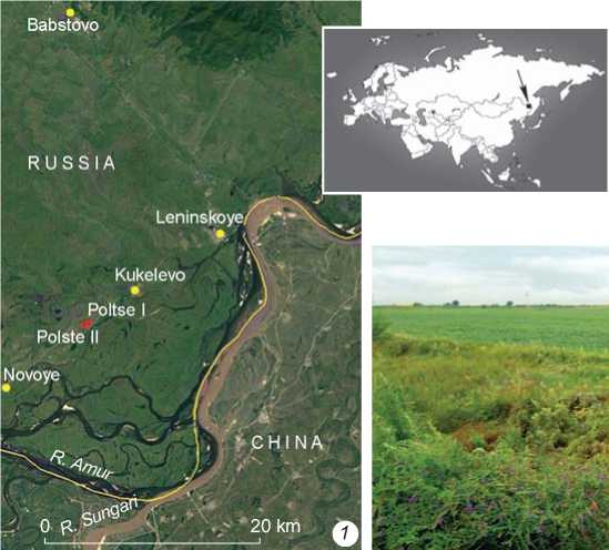
The first information about the location of the Poltse I archaeological site in the scholarly literature was provided by A.P. Derevianko in 1966. According to his description, the settlement was located 5 km from the village of Kukelevo, on a 3–4 m terrace gently sloping down to a significantly swampy oxbow lake, a former channel of the Amur River, 3–4 m from the road to the village of Babstovo (38 km), which ran along the edge of the terrace (Derevianko, 1966a: 230). More detailed information on the location was provided in the report on the 1966 excavations: “The settlement of Kukelevo-Poltse* is located… after the 138 km marker of the Birobidzhan–Amurzet road. The settlement extends along an old river bed (now a chain of oxbow lakes at a distance of 50 m) north of the road that cuts off the settlement from the bank, that is, most likely, cuts off its southern part—a good half of the settlement adjacent
CHINA
0 В-
Babstovo
Poltse I
Polste II
Novo ye
RUSSIA
Kukelevo
20 km t
Fig. 1 . Satellite image of the location of Poltse I and II ( 1 ), and view of the current state of the excavation areas of the 1960s at Poltse I from the south ( photo by S.P. Nesterov, 2016 ) ( 2 ).
to the channel. The bank near the settlement is high and steep, although without precipices. The settlement is bordered by fields on the north. Probably, part of it has been plowed over. The western edge of the settlement is more damaged: there is a noticeable ditch from the last surviving dugouts, covering about 70 meters along the bank. The dugouts are located in close groups. The last dugouts to the east survived under a shallow plowed valley overgrown with small oak trees. The settlement probably continued further to the slope of the terrace, but the road and fields of the collective farm are there” (Derevianko, 1966b: fol. 1). About a dozen deep (up to 1.5 m) cup-shaped depressions, with diameters of 8–10 m and bottoms overgrown with young oak trees and bushes (Fig. 1), were discovered there in 1962 in a dense oak forest (Derevianko, 1966a: 230). Therefore, the excavations that began in 1963 and continued in 1964, 1966, and 1967 involved partial cutting down of the trees (Fig. 2, 1 ).
During four years of permanent works at the Poltse I site, several more well-visible depressions were discovered, suggesting that the settlement consisted of approximately 20 dwellings. The settlement of Poltse II, partially destroyed to the south by the road and plowed over to the north, was discovered 200 m to the west of it. One dwelling out of 30 was explored there. Such close proximity of both settlements might have been caused by the terrain of the area at that time, or by their existence at different times; or Poltse II might have become a new settlement for the inhabitants of Poltse I, which perished from some catastrophic events as evidenced by traces of fire in nine out of the ten examined dwellings (Derevianko, 1976: 10, 83).
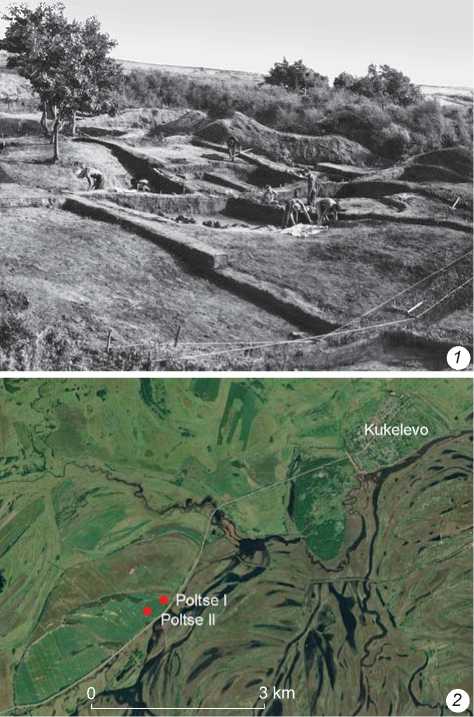
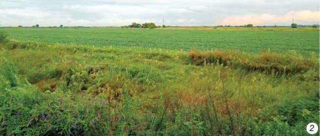
Fig. 2 . View of the excavation areas of the 1960s from the southeast (from the original photo made for the book by A.P. Derevianko (1976: 11, fig. 3)) ( 1 ), and satellite image of the terrace in Poltse with traces of arable land ( 2 ).
The further history of these sites was neither straightforward nor clear in the 1960s, when an open appeal was made to the local Party and administrative organs of the Soviet government for providing assistance with archaeological works. In spite of this, the directorate of the Leninsky State Farm (Director N.S. Vankin from 1964 to 1985), which included the Kukelevo division, for some unknown reason in the spring of 1968, without the consent of the archaeologists, gave an order to plow the terrace with the unexcavated sections of the Poltse I and II settlements*. Apparently, it had been plowed earlier. For example, on the upper boundaries of dwelling 10 discovered at a depth of 40–60 cm from the ground surface, “the western part of the northern wall was plowed over; its upper part was destroyed” (Ibid.: 81). Traces of plowing are still visible today (Fig. 2, 2 ).
Although research at Poltse I and II was interrupted, the sites were not completely destroyed. Since the depth of some depressions from the dwellings reached 1.0– 1.5 m, and the plowing depth did not exceed 30–40 cm, these objects must have survived. In the future, with new methods of visual study (satellite images, drones) and geophysical research, using excavations in continuous areas, it will be possible to return to these sites for creating a general instrumental topographic map and conducting new excavations. Being eponymous with the Poltse culture of the Eastern Amur region, the Poltse I and II sites still provoke active scholarly discussion concerning the role played by the carriers of this culture in the Far East in the second half of the Early Iron Age.
Spatial structure of the excavated part of Poltse I
In 1966, the first attempts at creating a general map of excavations at Poltse I were made. It was completed in the field on graph paper and included the outlines of three previously explored dwellings (No. 1–3), one dwelling (No. 4) unearthed in 1966, and two unexcavated dwellings (No. 5 and 6). Cross-sections were made through the subsquare depression of dwelling 6 along lines 33 (north– south) and Я (west–east). Digital and letter benchmarks were indicated on them, and the trench was shown on the cross-section along line Я. On the second, final general map, dwelling 5 was already marked as explored, and only baulk lines without marked pickets were drawn through the depression of dwelling 6. Therefore, information from the field drawing was chosen instead of this (Fig. 4). These maps have not appeared in any publications of materials from Poltse I.
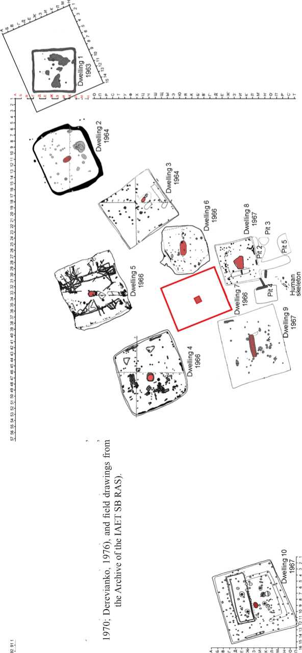
It was possible to make a general layout of the excavated dwellings because eight of them (except for dwellings 1 and 10) were included in a single excavation coordination grid (Fig. 5). However, this does not mean that the entire settlement area of approximately 2340 m2 was unearthed. In 1964, dwellings 2 and 3 were explored using one excavation pit. In 1966, dwellings 4 and 5 were studied separately, but were linked to the common grid. According to the description, “dwellings at the settlement were located close to one other, especially in its eastern part where the inter-dwelling filling was not removed. Only in the area of dwellings No. 5, No. 6, No. 8, and No. 9, was it possible to unearth about 50 m2” (Ibid.: 82). The space around dwellings 1 and 10, measuring 146 m2, can be added to this amount.
The map of the excavated dwellings shows that they were placed in two rows with a narrow space in between, i.e. a “street”. Dwellings 5, 4, and 10 can be included in the northwestern line, and dwellings 2, 3, 6, 7, and 9, in the southeastern line. Dwelling 8 adjoined the latter line, although was located further to the southeast. Noteworthy is dwelling 1, which was oriented to the cardinal points with its walls, whereas the other dwellings, with their corners.
Dwelling 1 (6 × 7 m) was the first structure explored in 1963. It was in this dwelling that the test pit was made in 1962, sized 50 × 50 cm, in which an intact vessel and fragment of a slate point were found. To excavate the dwelling, a two-meter grid was used (in subsequent years, works were carried out using a one-meter grid). The pit, rectangular in ground plan, was dug from the upper level of dense dark sandy loam, which lay immediately under the sod and had a depth of 1.1–1.2 m. The depression above it was 1.5 m deep. According to Derevianko, this pit contained a log construction, the lower layers of which left a groove 20–30 cm deep of a closed outline (1966a: 230–231). It was not possible to determine how high the layers of this log
Fig. 3 . General plan of the location of Poltse I, compiled in 1966 ( 1 ), and map of depressions on the eastern outskirts of the settlement, published in 1970 ( 2 ) and 1976 (3).
1 , 3 – from the original drawings made for the book by A.P. Derevianko (1976: 10, fig. 1, 2); 2 – after (Okladnikov, Derevianko, 1970: 26, fig. 2).
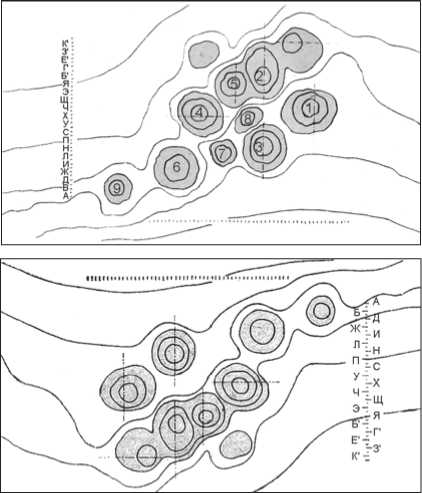
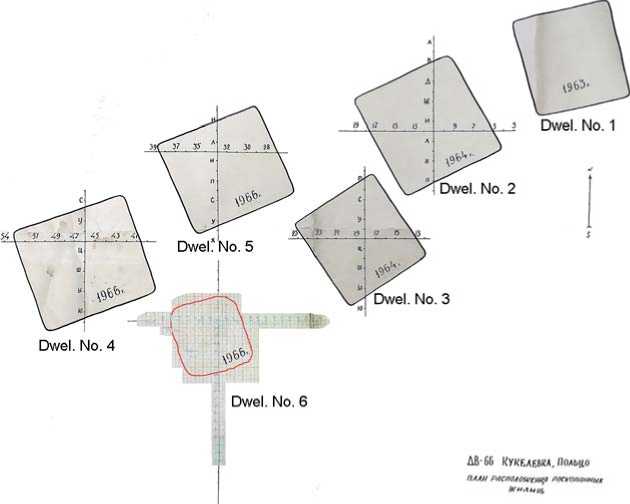
Fig. 4 . Copy of the map of dwellings excavated in 1963, 1964, and 1966, from the Archive of the IAET SB RAS, with an insert from a field drawing on graph paper.
house rose, because the building had burned down. The pit contained 10 small post holes about 20 cm in diameter and 20–25 cm deep. Larger holes were located in the middle. These were intended for supporting the roof (Okladnikov, Derevianko, 1970: 50). The combination of logwork and a frame-and-post structure is known from winter buildings of the Yakuts on the Olenyok River (Istoriko-etnograficheskiy atlas…, 1961: 145). The structural features of dwelling 1, located on the northeastern outskirts of the settlement, could have been related to its purpose: “the absence of a hearth and the abundance of clay vessels of various types and sizes suggest that… a communal storage place for the entire village was located there” (Derevianko, 1966a: 242). If this was the case, the logwork placed in the deep pit protected supplies in the winter and served as a cellar in the summer. Food supplies were stored in containers of various sizes. Some vessels had burnt food residue on their surface. Thirteen bowls, two goblets, and a vessel with a
Fig. 5 . Map of excavations at Poltse I in 1963, 1964, 1966, and 1967 (after (Okladnikov, Derevianko,
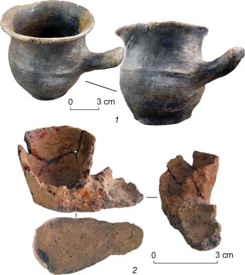
side handle in the shape of a horn (Fig. 6, 1 ), which could have been used to measure food, were also found there.
Dwelling 2 (10.8 × 8.6 m) was located approximately 6 m to the west of dwelling 1 (see Fig. 5). It was quadrangular in plan view, with rounded corners. It was a frame-and-post structure built in a pit 1.1 m deep (“not differing from the rest of the dwellings at this ancient settlement” (Okladnikov, Derevianko, 1970: 110)). To the east, dwelling 2 started the part of the village with buildings oriented with their corners toward the cardinal points. It was included in the southeastern row, but was slightly shifted in the northwestern direction. To the northeast, the “street” ended at dwelling 2. Its specific features include a relatively small hearth (1.2 × × 1.0 m) and the presence of a large number of various vessels, including 38 bowls, five so-called lamps, three spindle whorls, and a small double vessel with traces of red paint (see Fig. 6, 2 ) (Ibid.: 53–110).
Dwelling 3 (9 × 10 m) had a quadrangular shape in plan view. It was located 4 m southwest of dwelling 2 and parallel to it, in a pit 30–40 to 50–60 cm deep (see Fig. 5). The oval hearth was shifted to the southeastern wall. Its size was 1.7 × 0.84 m; the depth of the hearth pit was 22 cm. The dwelling had a frame-and-post structure. Posts supporting the slopes of the roof were located in the middle in a circle. Some supported corner rafters, while others supported the middle part of the roof. It is possible that the posts stood under four corners of an upper frame that formed the smoke hole. Apparently, because of the large area of the roof and its heaviness, a large post supporting the upper ends of the corner rafters was set in the center (Ibid.: 110–147).
Dwelling 4 (11 × 10.5 m), which was located 17 m from dwelling 3 and approximately 6 m from dwelling 5, was investigated in 1966 (see Fig. 5). It was in a pit about 1.2 m deep and had a frame-and-post structure. Scholars have mentioned the unevenness of its floor, which rose sharply in the center. A rise in a strip of 80–100 cm was also observed along the walls. A hearth of round shape approximately 1.3 m in diameter was located almost in the center, with a slight shift to the southwest. It is
Fig. 6 . Vessels from dwellings 1 ( 1 ) and 2 ( 2 ). Museum of History and Culture of the Peoples of Siberia and the Far East of the IAET SB RAS. Photo by S.P. Nesterov .
marked in sq. Ч-46 on the ground plan, while in crosssection, it is along line 46, and there is a depression in this place. In addition to the hearth, another large object inside the dwelling was a stone 42 × 33 × 65 cm in size, which, according to the description, was located in sq. Ч-45 (Ibid.: 147). However, this must have been a misprint because on the map it is located near the northeastern wall in sq. Ч-42. Another feature of dwelling 4 was the presence of a human skeleton inside, which was oriented with its skull towards the center of the building (Ibid.: 184). It was assumed that these were the remains of the inhabitant of the dwelling, who died during an enemy attack on the village. The invasion was sudden; based on the large number of vessels left in the dwellings, the inhabitants left them in a hurry. Interestingly, the person was very well equipped, with protective armor made of bone and iron plates, and a set of arrowheads (quiver), and could well have been a warrior from among the attackers who entered the dwelling and was killed there.
Dwelling 5 (8.95 × 9.6 m) had a sub-square shape in plan view and was built in a pit 50–60 cm deep between dwellings 2 and 4 (see Fig. 5). A hearth measuring 1.0 × 0.6 m was located almost in the center. A special feature of this building as an archaeological site was the preservation of a large number of charred parts of its frame-and-post structure. This allowed Derevianko to reconstruct the internal structure and external appearance of the dwelling (Fig. 7, 1 ) (1976: 133, fig. 85).
Dwelling 6 . The depression above this dwelling, unlike the other depressions of sub-quadrangular shape, was cupshaped. The leaders of the excavations mentioned that it was located in the center of the settlement, 2 m from the
corner of dwelling 3 in the east and 4 m from the wall of dwelling 5 in the north (Okladnikov, Derevianko, 1970: 228). However, according to the compiled excavation map, the distance to dwelling 5 was approximately 7 m (see Fig. 5). This dwelling was distinguished by the absence of traces of fire. Scholars have suggested that it was abandoned by its inhabitants due to a state of disrepair (Ibid.: 242). The closeness of dwellings 3 and 7 to dwelling 6 could have been caused precisely by the proximity to the old foundation pit. The approximate size of dwelling 6 according to the baulks was 6.5 × 6.4 m (Derevianko, 1976: 57, fig. 47). A hearth elongated along the west–east line was in the middle. Its size was 2.35 × 1.35 m; the depth of the hearth pit was 20 cm.
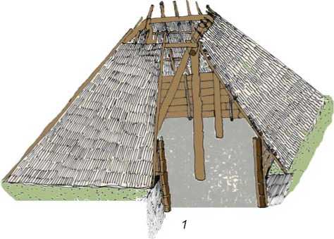
Fig. 7 . Visual reconstruction of a Poltse dwelling ( 1 ), and human skeleton found near dwelling 8 ( 2 ).
1 – from the original drawing made for the book by A.P. Derevianko (1976: 133, fig. 85); 2 – from the field drawing kept in the Archive of the IAET SB RAS.
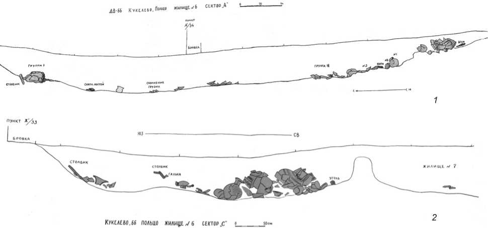
Fig. 8 . Copies of the field drawings representing the contour cross-sections of dwellings 6 ( 1 ) and 7 ( 2 ) before their numbers were changed. Archive of the IAET SB RAS.
A protrusion similar to an entrance vestibule was on the northwestern side of dwelling 6. Multiple fragments of various ceramics occurred in the filling of the dwelling pit, suggesting that the inhabitants of neighboring dwellings used the pit for waste at the settlement.
Dwelling 7 (8.5 × 9.5 m) adjoined dwelling 6 to the southwest. Field drawings include contour cross-sections along line 34: south–north and southwest–northeast. The cross-section along the southwest–northeast was made from the edge of the baulk along line 33, from its intersection with line Ж’, located south of the contour of dwelling 7, through a cluster of ceramic vessels in sector C. It also captured the northwestern part of dwelling 6, passing through the inter-dwelling space with the smallest distance between two buildings reaching only 32 cm (Fig. 8). Notably, the southwestern dwelling was marked as No. 6 and northeastern as No. 7 on these cross-sections. When the evidence from the first six dwellings was published, dwelling 7 appeared as No. 6 (Okladnikov, Derevianko, 1970: 241) and in the later monograph by Derevianko, the working numbering of dwelling No. 6 was adjusted to No. 7 (1976: 59)*.
Dwelling 8 (6.8 × 6.0 m) was bordered by dwelling 9 to the west and dwelling 7 to the north (see Fig. 5)
*However, the numbers were changed only in the publications (Okladnikov, Derevianko, 1970: 228–242; Derevianko, 1976: 56–59). In the Repository of the IAET SB RAS, the labels on the boxes with materials and on the vessels from these dwellings, as well as the codes, have remained unchanged. The numbers of dwellings correspond to the original field numbering, which is reflected in field drawings stored in the Archive.
(Ibid.: 68–69, 314–315). The hearth was located in the middle and presumably had an irregular pentagonal shape with rounded corners and a size of ~1.65 × 1.24 m. This structure was distinguished by an entrance corridor approximately 5 m long and 1.4 m wide near the southwestern corner, four pits (No. 2–5) on the southern side, and a human skeleton without a skull to the southwest of the entrance (see Fig. 7, 2 ) (Ibid.: 82, fig. 73).
Dwelling 9 was almost square in shape (11.0 × 10.6 m) and was located to the west of dwellings 7 and 8 (see Fig. 5). An elongated hearth measuring 3.6 × 1.0 m was in the middle (Ibid.: 69–75, 316–322). This dwelling contained a large number of vessels, which occupied almost its entire space (Fig. 9).
Dwelling 10 was located 30 m to the west of dwelling 9 (see Fig. 5). Its location and the reference to the general grid were established conventionally, using this information. This dwelling had its own coordinate system marked on field drawings of 1967 as excavation pit II, dwelling No. 1. Only in the publication of 1976 was it assigned No. 10* (Ibid.: 75). Dwelling 10 was quadrangular in shape and measured 11.6 × 9.9 m.
Some spatial features of the Poltse I settlement (instead of a conclusion)
Despite some linearity in the placement of dwellings at the settlement, they were generally built quite close to
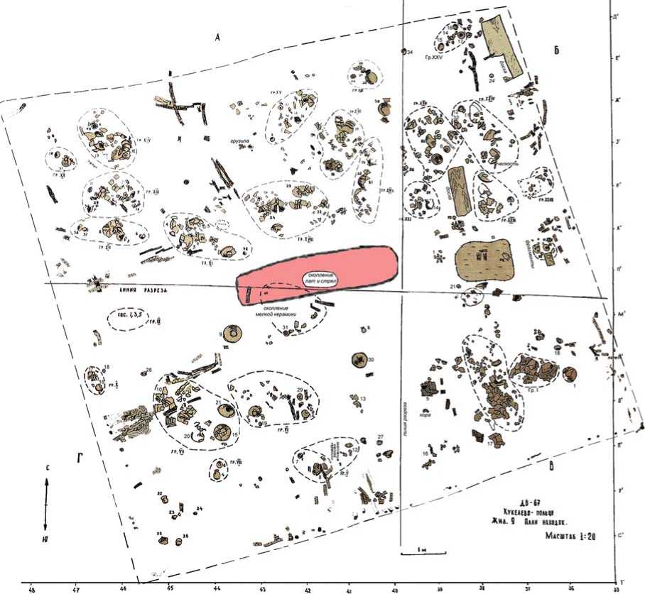
Fig. 9 . Map of location of the finds in dwelling 9 (from the field drawing on graph paper; the outline of the dwelling and hearth were copied from other maps). Archive of the IAET SB RAS.
each other. The location of dwelling 10 at a distance from the main excavated group was associated only with the choice of locations for excavations. In this space, dwelling depressions were also present; and 200 m to the settlement of Poltse II was also a small distance. According to A.P. Derevianko and V.E. Medvedev, who participated in the excavations of the 1960s, both sites could have formed one large village with at least a hundred residential and utility buildings.
Specific features of the excavated dwellings included their varying sizes and presence of numerous pottery vessels of various types (see Table ). The large area of a building did not always correspond to a large amount of pottery inside. The small number of vessels in dwelling 6 was a result of its poor state of repair. Owing to the disrepair of the building, everything of value had been removed from it. Subsequently, it could have been
Main features of dwellings
In the inter-dwelling space, fifteen intact and broken vessels, spindle whorls, a ceramic ring, a rectangular adze, mallets, a fragment of a pestle, fragments of slate and bone arrowheads, retouched items, and animal bones were found (Ibid.: 82–83). Eight pits of different periods, which had a possible utility and garbage purpose, were discovered in the excavated area of the settlement. For example, a Neolithic waste pit with soil containing fish bones was found behind the northern wall of dwelling 4.
The collection of ceramic vessels from the excavated area of the Poltse I settlement totals 965 items (excluding numerous fragments). Most vessels were intact or archaeologically complete; 950 of them were found directly in dwellings. The pottery was predominantly concentrated in dwellings 1–5, and 9. Scholars identified the purpose of the relatively small dwelling 1 without a hearth as a public store house. The other four structures, 2–2.5 times larger in area, with hearths which were too small for such spaces, can be figuratively called “china shops”. In the dwellings containing a large amount of pottery, there were vessels inserted one into the other, bowls stacked in a stack, and containers covered with bowls as a lid. This is clearly a way to store utensils to save space. Some large vessels contained millet. Judging by the layout of finds in dwelling 9, they were located along its perimeter (Fig. 9). The center and the area from the center to the middle of the southwestern wall, where the entrance was most likely located, remained relatively free. The inhabitants of the dwellings used only a small part of the vessels in everyday life, while the larger part was presumably intended for trade and exchange. The source of the pottery—whether domestic production or imported goods—has not yet been clearly identified.
Acknowledgments
The author thanks the Academician A.P. Derevianko, Dr. V.E. Medvedev, Academician V.I. Molodin, Dr. V.P. Mylnikov, Dr. T.I. Nokhrina, and leading specialist Y.A. Plotnikov for their help in preparing this article, as well as Dr. E.V. Parkhomchuk and the team from the Center for Collective Use “Geochronology of the Cenozoic” for analyzing the soil from the Neolithic pit.
