Stoilo—A Paleolithic Site in the Southern Angara Region, Siberia

Author: Kuznetsov A.M., Molchanov D.N., Kogai S.A.
Journal: Archaeology, Ethnology & Anthropology of Eurasia @journal-aeae-en
Section: Paleoenvironment, the stone age
Article in issue: 4 т.51, 2023.
Free access
On the basis of findings of the autumn 2021 field season, we present the first information on the Paleolithic site of Stoilo (Usolsky District of the Irkutsk Region). The site, located on the left bank of the Angara River, belongs to the Belaya geoarchaeological region. The complex is enclosed in pre-Holocene sediments relating to the residual gruspebble crust, which overlies the soliflucion layer tentatively dating to the Late Karga–Early Sartan period. The analysis of the lithics, mostly made on siliceous rocks, indicates prismatic reduction resulting in small blades. The toolkit consists of small pieces, including various types of spurred tools, burins, knives on naturally backed blades, retouched blades and flakes with use-wear, and a heavy-duty pebble tool. A specific feature of the complex is that most artifacts reveal superficial traces of minor corrasion—a weak surface gloss. This and the fact that the material relates to the gruspebble layer might be viewed as formal indicators of the “Makarovo Horizon”. However, the totality of typological and technological features and the structure of the sediments suggest that Stoilo represents the middle stage of the Upper Paleolithic, dating to the Early Sartan stage. To confirm this assumption, further excavations are needed in order to augment the collection and obtain more environmental data.
Baikal Siberia, Southern Angara, Paleolithic, deflation, corrasion, Sartan stage, blade reduction
Short address: https://sciup.org/145146951
IDR: 145146951 | DOI: 10.17746/1563-0110.2023.51.4.015-024
Text of the scientific article Stoilo—A Paleolithic Site in the Southern Angara Region, Siberia
The Belaya geoarchaeological region includes a 100km stretch of the lower Belaya River with tentative bank boundaries, where the best-known key stratified geoarchaeological sites of Baikal Siberia (Georgievskoye I, Malta, Sosnovyi Bor, Ust-Belaya, Galashikha, and others), documenting the successive evolution of material culture from the Middle Paleolithic to the Nomadic Age, are situated (Fig. 1) (Problemy…, 1996; Kamennyi vek…, 2001). This region includes the site of Stoilo, where pilot excavations were conducted in the autumn of 2021. The site was discovered by the Angara Expedition from the
State Academy of History of Material Culture in 1934. Archaeological mapping of the Usolsky District specified the geographical position of the site (Ukazatel…, 1991: 81–82). However, no excavations have been conducted there until recently.
The excavations of 2021 revealed the presence of Holocene archaeological remains recorded over a large area and resembling those described by the Angara Expedition. The lithic industry comprised prismatic and wedge-shaped cores, single end-scrapers, knives, prismatic blades, flakes, and fragments. Identifiable fauna remains included bones of Siberian roe deer ( Capreolus pygargus ). The archaeological materials were

Fig. 1. Eastern part of the Belaya geoarchaeological region.
recovered from the lower part of the layer attributable to the Holocene Climatic Optimum (AT), whose upper face was partially destroyed and overlain by a humusaccumulating horizon of modern soil. One of the test pits contained fragments of plain pottery with imprints of retreating paddle, tentatively dating to the Late Neolithic/ Bronze Age.
The most interesting results, however, were obtained from the northern part of the site. There, in a test pit, subsequently enlarged to a small trench (5 × 2 m), a lightly corraded lithic complex of Paleolithic appearance was recorded in the stratigraphic position. Here, we introduce new data on stratigraphy, deposit composition, and finds relating to this complex. Also, the first attempt is made at correlating these data with the available information on similar sites of the Belaya geoarchaeological region and Baikal Siberia in general.
Geomorphology and composition of Stoilo section
Geomorphologically, the study area is located on a gently sloping surface of the Angara left bank, at an elevation of 414–416 m (Baltic Height System). Relative height above the water’s edge during the period of the present study was 14–16 m. However, according to A.P. Okladnikov, before the cascade of the Bratsk Hydroelectric Power Station on the Angara had been formed, the terrace was 18 m high (Sosnovskiy et al., 1934: 40).
The lower portion of the bank is composed of gray tabular dolomites of the Lower Cambrian Angara suite (Cm1 an ), whose exposures are visible along the whole left bank of the Angara in that region (Geologicheskaya karta…, 1961: 14–16). They are overlain by boulders and pebbles tentatively attributable to the Zalari suite of the Lower Jurassic (J1 zl ). Loose sediments from 0.5 to 2.3 m thick cover the upper portion of the bank.
In the northern part of the site (test pit 5, trench), where Paleolithic artifacts were discovered, the section revealed a complex structured sequence consisting of lithologically different sediments, including both subaerial layers (1–8) and an earlier subaqual layer 9 (Fig. 2). Each stratum records changes in conditions of sedimentation, and signals certain environmental and climate events. Below follows the interpretation of the section, including the age of some strata, in accordance with the regional climate-stratigraphic scheme (Vorobieva, 2010).
Layers 1–4 can be attributed to the Holocene. The upper portion of this sedimentary unit is severely disturbed by human activities. Okladnikov mentioned that the first finds from this site in the early 20th century were collected from the surface (Sosnovskiy et al., 1934: 42). Plowing reworked the Subboreal–Subatlantic sediments (SB–SA; up to ~4.6 ka uncal BP) into one humus-accumulative horizon. Judging by spots in the lower part of layer 2, the roof of layer 3, belonging to the Atlantic Climatic Optimum (AT; ~8–4.6 ka uncal BP) and possessing a diagnostic pale-yellow–brown coloration, was also destroyed in the process. Layer 4, tentatively attributed to the Early Holocene (PB–BO; ~10.3–8 ka uncal BP), is indistinct in the section; however, visible black spots therein may indicate the presence of derivatives of Early Holocene soils. Noteworthy is a network of small inserted cryogenic wedges of Middle and Early Holocene horizons. This can possibly be correlated with some cooling and decrease in humidity of the climate during the Boreal/Atlantic transition.
Layers 5–8 can be attributed to the Final Pleistocene. The Pleistocene to Holocene transition is distinctly traceable by diagnostic features such as carbonization of layer 5 (Sr4; ~14–10.3 ka uncal BP) and a wavy boundary between layers 5 and 4, reflecting typical cryogenic “knolls” of thermo- and cryochrone contact. Layer 6 shows Sartan loess-like loams (Sr3-2; ~18–14 ka uncal BP), pointing to periglacial subaerial conditions. The loams are more porous than the Holocene sediments.
Sediments of layer 7 and below are the most problematic in terms of origin and age. All subsequent statements about them are tentative. The lower portion of layer 7B possibly represents the Late Sartan solifluction (Sr11 (sol); ~24–21 ka uncal BP) with fragments of Late Karga and presumably Early Karga formations (Kr; ~57– 24 ka uncal BP). The surface of the solifluction-affected sediments is marked by residual deflation crust 7A, formed during the second half of the Early Sartan period (Sr12; ~21–18 ka uncal BP). A similar sequence of events (cryogenesis (solifluction) → deflation) was recorded in several sections in the Angara basin, though there it was
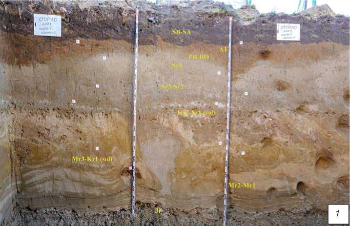
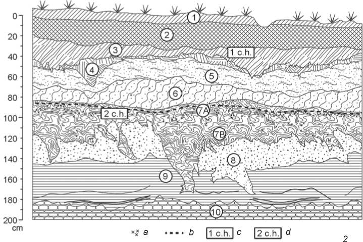
Fig. 2. Photograph ( 1 ) and drawing ( 2 ) of the stratigraphic section of the geoarchaeological site of Stoilo. a – grus and pebbles; b – carbonate sublayer; c – Neolithic complex; d – Paleolithic complex.
attributed to the Murukta age (Vorobieva, Medvedev, 1984: 23). However, one and the same scheme, on the basis of cyclicity of environmental and climatic processes, can be applied to the Early Sartan period, too. Formation of the grus-pebble layer most probably was associated with transport of fine pebble and sand fractions down the slope. This movement was caused by aeolian processes, which involved pebbles of the Zalari suite. Pulling the grus-pebble lenses into “pockets” was connected with cryogenesis.
Maximal climate aridization during the subsequent period led to the formation of a carbonate sand layer:
water flowing down the pebble crust and carrying suspended particles of silt rapidly evaporated, causing intense carbonization rather than overmoistening of the ground. The age of carbonates in the roof of layer 7 can be tentatively estimated by analogy with Early Sartan dates of carbonate cutans in Taiturki II section, located within the Belaya geoarchaeological region, 15 km in a straight line from the site of Stoilo (Golubtsov, Cherkashina, Snytko, 2019).
The question of filling the cryogenic wedges with fine washed sand in layer 7 remains open. It is possible that there occurred a short-term episode of flooding the surface as a result of seismic-tectonic movements or a high water during the Late Karga period. In such a case, formation of the cryogenic wedges, which were subsequently covered by the solifluction flow, occurred during the Konoschel cooling (~33 ka uncal BP) (Vorobieva et al., 2010; Kind, 1974: 117).
Underlying layer 8 also has a complicated genesis. The reason for separating solifluction layers 7 and 8 was the change in composition and color of sediments, marking the transition to a new climatic stage. The preserved fragments of pink loams in the upper portion of layer 8 can be interpreted as remains of Early Karga (Kr1) horizons of weathering. The rest of the layer consists of solifluction-affected sediments of the Late Murukta age (Mr3 (sol); ? –57 ka uncal BP): sands and sandy loams of yellow hues. A rodent burrow filled with heavy brownish loam may contain the remains of Karga (?) soils. Layer 9, composed of sands and sandy loams, is interpreted as Middle Pleistocene (?) flood-plain facies reworked by Early Murukta (Mr1–2; ~71–? ka uncal BP) aeolian processes. Underwater sediments have been preserved in their original horizontal thin-layered form only in the lowest part of the section.
Technical and morphological characteristics of the lithic industry
Archaeological assemblage from Stoilo comprises solely lithic artifacts (Table 1). Most of them (170 of 396 spec.) are debitage: shatters, chunks, and chips. Over 90 % of the artifacts were made of siliceous rocks. Sources of raw material most probably were exposures of siliceous concretions in dolomites of the Lower Cambrian Angara suite distributed throughout the Belaya geoarchaeological region in bank exposures of the Angara and its tributaries (Kamennyi vek…, 2001: 72). Quartzites of various grain sizes occur in small numbers. Most artifacts demonstrate traces of
Table 1. Main categories of the lithic industry
|
Category |
Number |
% |
|
Core-like fragments |
6 |
2.7 |
|
Core-trimming elements |
81 |
35.8 |
|
Blades |
43 |
19.8 |
|
Bladelets |
10 |
4.4 |
|
Flakes |
86 |
38.0 |
|
Debitage |
170 |
42.9 |
|
Total |
396 |
100 |
Note : Percentages of the first five categories refer to the total number excluding debitage (shatters, chunks, and chips). Percentage of debitage refers to the total number of lithic artifacts.
carbonization. These are chiefly small spots of carbonate crust; however, some pieces are completely covered with carbonates on one face or a margin.
There are six core-like fragments in the collection, including a fragment of flaking surface of a core for blades (Fig. 3, 1 ), a fragment with scars of blade removals on a narrow flaking surface, with a natural platform (Fig. 3, 2 ), and a fragment of a lateral part of a core for blades with flake scars shaping an arris (Fig. 3, 3 ). The industry of spalls numbers 220 spec. (Table 1). Fragmented pieces form a high percentage; unbroken items are 40 % only. Linear dimensions of the artifacts are small; maximal length of most of them does not exceed 70 mm.
Core-trimming elements are numerous; complete pieces number 51 spec. They reflect all stages of primary reduction, from decortication to rejuvenation of working faces and striking platforms (Table 2). The presence of items typical of prismatic reduction should be noted. These comprise semi-tablets (Fig. 3, 5 ), including secondary flakes; a flake resulted from trimming of the flaking face (Fig. 3, 4 ); longitudinal lateral flakes; and semi-crested blades. Preparation for detachment of coretrimming flakes was normally minimal; in most cases, the detachment was made from natural or plain surfaces. Striking platforms were mainly 4–9 mm deep. Two thirds of the flakes bear bulbs of percussion, whether distinct or blurred, in equal shares. Natural cortex is present on approximately 55 % of complete pieces (Fig. 3, 6 ).
Among 86 flakes, 22 pieces are complete. Their length varies from 17 to 42 mm; the width falls within the range from 14 to 38 mm. The flakes exhibit dorsal treatment (45 %), unidentifiable (23 %), orthogonal (18 %), or bilongitudinal (14 %). Natural cortex is present on 46 % of complete specimens. Platforms of the flakes are mainly natural (39 %) and plain (21 %); dihedral (11 %), polyhedral (7 %), facetted (4 %), and destroyed (18 %) platforms are also present. Seven flakes demonstrate platform rejuvenation by direct percussion. The depth of the platforms varies primarily from 3 to 7 mm. Bulbs of percussion are visible on 65 % of the flakes, 29 % of them are distinct, and 36 % are blurred.
Nine of 43 blades are complete. They are 33–56 mm long and 13–32 mm wide. Dorsal scar pattern on the blades is mostly longitudinal and unidirectional (44 %); semicortical, orthogonal, and unidentifiable varieties are less common. Remnants of natural cortex are present on 56 % of the complete specimens. Striking platform remnants are plain (43 %), destroyed (29 %), natural (14 %), or dihedral (14 %). Most of them are 2–5 mm deep. Eight specimens demonstrate rejuvenation of platforms performed by direct percussion. Bulbs of percussion are present on 47 % of proximal parts of the blades; 22 % are distinct and 25 % are blurred.
The majority of bladelets (seven of ten) are complete. Most of them measure within the range of 27 to
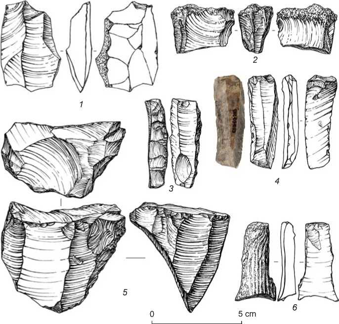
Fig. 3. Core-like fragments and core-trimming elements.
32 × 9 to 10 mm. Dorsal scar pattern is exclusively longitudinal; three bladelets retain cortex. Platforms are destroyed in half of the cases. Some of them are plain (25 %), natural or dihedral (12.5 % each). Two specimens show rejuvenation of platforms by direct reduction. In most cases, the platforms are 1–2 mm deep. Bulbs of percussion are present on 26 % of the bladelets, including 12 % distinct and 14 % blurred.
The toolkit consists of 43 items. Flakes and blades were used as blanks almost in equal shares; two tools were fashioned on bladelets. Complete specimens constitute 21 %.
Formal tools (25 spec.) are represented exclusively by Upper Paleolithic types. Spurred tools (points, according to the typological list of Malta site (Kamennyi vek…, 2001: 70)) are most numerous (9 spec.). Blades (Fig. 4, 3 , 4 ), bladelets (Fig. 4, 9 ), flakes (Fig. 4, 7 ), and undiagnosable pieces (Fig. 4, 2 , 5 , 6 , 8 ) were used as blanks. On most tools, a spur was fashioned by notches or fine marginal retouch.
There are five burins in the collection. All of them have a lateral working edge (Fig. 4, 10–12 ). Burin spalls were struck from surfaces that were unprepared or prepared by one removal only. Knives on blades (4 spec.) have natural backs opposing the working edge with traces of retouch (Fig. 4, 13 , 14 ; 5, 2 , 7 ).
Table 2. Core-trimming elements
|
Variety |
Number |
% |
|
Flaking surface rejuvenation flake |
25 |
30.9 |
|
Decortication flake |
19 |
23.5 |
|
Natural lateral flake |
16 |
19.7 |
|
Debitage surface preparation flake |
7 |
8.6 |
|
Semi-tablet flake |
4 |
4.9 |
|
Longitudinal lateral flake |
3 |
3.7 |
|
Semi-crested blade |
2 |
2.5 |
|
Transverse lateral flake |
2 |
2.5 |
|
Core convexity maintenance flake |
1 |
1.2 |
|
Secondary semi-tablet flake |
1 |
1.2 |
|
Plunging flake |
1 |
1.2 |
|
Total |
81 |
100 |
Two artifacts are retouched blades. In one case, the working element was formed by dorsal subparallel extensive retouch on the longitudinal edge (Fig. 5, 5 ); on the second artifact, by dorsal marginal retouch on the longitudinal edge and by subparallel extensive retouch at the proximal end (Fig. 5, 8 ). “Beaked” tools (2 spec.) are morphologically similar to the spurred tools, but have thicker distal parts (“beaks”), modified by retouch. On
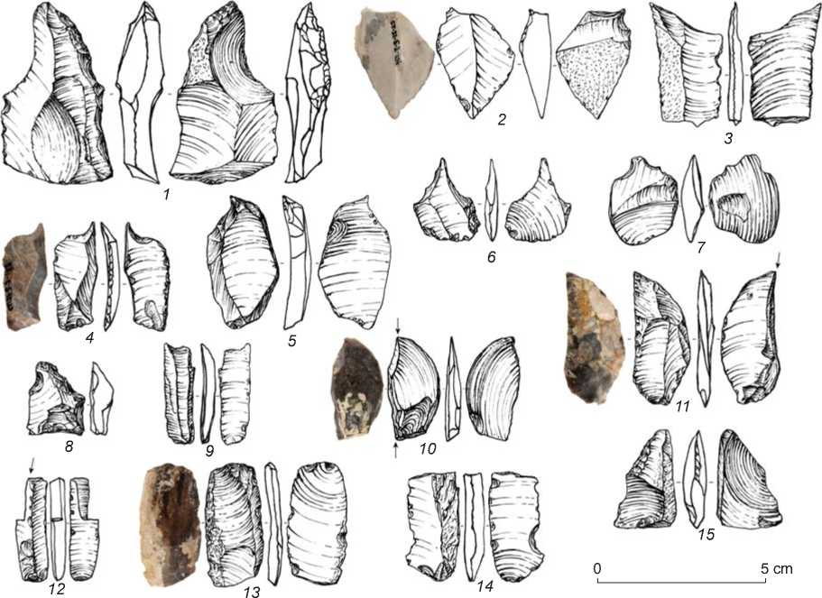
Fig. 4. Stone tools.
1 – “beaked”; 2–9 – spurred; 10–12 – burins; 13 , 14 – naturally backed knives; 15 – fragment of a tool.
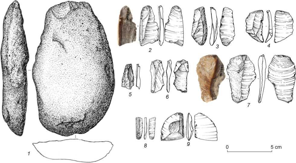
Fig. 5. Stone tools.
1 – tool on a cobble; 2 , 7 – naturally backed knives; 3 – blade with a distal working edge; 4 , 6 , 9 – flakes with utilization retouch;
5 , 8 – retouched blades.
one tool, extensive retouch covers the ventral face of the artifact; in the other case, it is located on the both faces (see Fig. 4, 1 ).
The collection comprises one blade with a working edge located on the distal end. The working edge was shaped by crude abrupt retouch, and the cross-section of the blade is beveled from the right to the left margin (see Fig. 5, 3 ). The only fragmented tool is an elongate flake with a functional element shaped by regular subparallel extensive retouch on the left margin (see Fig. 4, 15 ). A massive tool, fashioned on a flat cobble, is also singular. Its working element was formed by a series of short removals from the dorsal face; its edge is blunted. The right edge has an area with intensive microflaking, occupying a half of the artifact’s length (see Fig. 5, 1 ). This piece can probably be attributed to the category of percussive-abrasive unmodified tools (Stepanova, 2015), and its edge was formed in the process of using the implement.
The category of non-formal tools comprises flakes, blades, and bladelets, without traces of intentional modification, but with use-wear marks such as weakly-modifying retouch, denticulate-notched areas, or a glossed edge (see Fig. 5, 4 , 6 , 9 ). Such tools number 18 spec., including ten blades, seven flakes, and one bladelet. The separation of non-formal tools from flakes was motivated by the presence of tentative use-wear signs on some pieces. Most of them lack such traces, ruling out the effect of post-depositional processes on the artifacts’ edges. Future work will either provide clearer criteria for separating this category of tentative tools, or exclude them from the toolkit.
The analysis of the industry has shown that primary reduction, manufacture, and utilization of tools proceeded at the site. Blocks of raw material had apparently been transported here, but final judgment must be postponed until the excavation area is widened and the collection enlarged. The dominance of siliceous rocks can be explained by utilization of local sources of raw material. The high percentage of dorsal faces with preserved cortex on all kinds of spalls (43–56 %) can be indicative of small sizes of raw material pieces.
Primary reduction was clearly aimed at the blade production. It can be assumed that prismatic technique was utilized to detach small blades and bladelets. Judging by dorsal scars, tool blanks were received mainly by unidirectional longitudinal technique; if necessary, striking platform and laterals of the core were trimmed.
The formal toolkit is rather specific: spurred tools, burin- and knife-like implements prevail, with the complete absence of any end-scrapers. A typical feature is small size of the tools; even flakes not exceeding 2 cm in length were used.
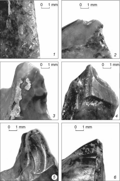
Fig. 6 . Surfaces of working elements on stone tools.
1 – fragment of a tool (see Fig. 4, 15 ); 2 , 6 – truncation burins (see Fig. 4, 10 , 11 ); 3 – “beaked” tool (see Fig. 4, 1 ); 4 , 5 – truncation burins.
Thus, the following characteristic features of the assemblage have been revealed: uniformity of raw material, high concentration of lithic artifacts, absence of typologically distinct cores, high percentages of core-trimming elements and tools. Accompanying features include traces of corrasion present on most complete artifacts as a weak surface gloss . At the micro level, signs of corrasion include flattened relief of surfaces and smoothed negative scars of microflaking on retouched implements (Fig. 6). According to the gradation suggested by G.I. Medvedev, artifacts of this complex demonstrate the second or third degree of corrasion (Medvedev, Sklyarevskiy, 1982).
Discussion
A specific feature of Stoilo Paleolithic complex is the evidence of corrasion on lithic artifacts. A related question concerns the age and origin of encompassing sediments, marked by the residual grus-pebble crust. Corraded assemblages of “soft” rocks (not quartzite) in the Angara and Lena basins are traditionally attributed to the “Makarovo Horizon” (Makarovsky plast)––a conventional group of artifacts similar in terms of relative stratigraphy, degree of corrasion determined by aeolian processes, petrography, and morphology (Medvedev, 1983b; Medvedev, Sklyarevskiy, 1982).
In his doctoral dissertation on the Paleolithic of the Angara basin, Medvedev described the stratigraphic position of this group as a sand and pebble sublayer separating the lower and upper units of the Early Sartan solifluction deposits (1983a). Lithic assemblages of the “Makarovo Horizon” are considered as redeposited, while the period of aeolian activity that affected them is ascribed to a “short-term” episode of extreme deflation in the region in the conditions of paleo-desert environment during the Early Murukta age (70–60 ka uncal BP) (Medvedev, 2001). Technical and morphological characteristics of these assemblages are as follows: “week to moderate degree of corrasion of artifacts’ surfaces; presence of cores of terminal-lateral technique of reduction for blades and bladelets; presence of bifacial technique; presence of burins and chisel-like tools; presence of points, convergent and déjeté scrapers” (Medvedev, Novoseltseva, 2011: 108–109). Proceeding from technological and morphological aspects of artifacts, degree of corrasion, and stratigraphic context, Medvedev referred complexes of the “Makarovo Horizon” (Gora Igetey I, horizon VI of Sosnovyi Bor, and Makarovo IV) to the Late Middle/Early Upper Paleolithic (Medvedev, Sklyarevskiy, 1982; Medvedev, 2001).
M.P. Aksenov had a somewhat different view on the age of Makarovo IV—a key site of the “Makarovo Horizon”. He examined the depositional context of archaeological remains at the site and noted the presence of Mururkta horizons unaffected by denudation in the underlying sediments, and remains of Late Karga soil horizons in the overlying units. Thus, the grus-pebble sublayer with corraded artifacts at Makarovo IV was associated with the Early Karga formations affected by denudation during the Konoschel cooling; therefore, it could be dated to 50 (55) – 33 ka uncal BP (Aksenov, 2009: 198). The age of the archaeological material was the same: Aksenov believed that its redeposition occurred by a slight linear shift down the slope, whereby the cultural horizon was destroyed by aeolian processes, and the enclosed artifacts covered the deposits enforced by pebbles.
A different view of the “Makarovo Horizon” was expressed by E.P. Rybin and A.M. Khatsenovich (2020). Focusing on technological and morphological aspects, they note that the Makarovo IV industry contains both corraded and uncorraded artifacts, and that industries included in Makarovo IV (Gora Igetey I and Kolpakov Ruchey) lack common features. Makarovo IV, therefore, is an amalgam of Late Upper Paleolithic types (endscrapers on blades, and carinate ones) and those of the Initial Upper Paleolithic (high frequency of small blades, trimmed and stemmed points, foliated points with bifacially thinned bases). Questioning the “Makarovo Horizon” as an umbrella term, Rybin and Khatsenovich believe that this industry was either a mixture or a highly unusual Baikal version of the blade complex dating to the Initial Upper Paleolithic. In the latter case, Makarovo IV dates to the Karga stage.
In this regard, the following points concerning the stratigraphy, corrasion, and technical and morphological characteristics of artifacts of Stoilo should be noted. A distinctive feature of Stoilo stratigraphic section is the evidence of solifluction processes in the sediments incorporating the grus-pebble sublayer. Taking into account the gap manifested by the change in composition of the solifluction sediments (loams–sandy loams), its upper section can be dated only to the Early Sartan period. Given that corrasion is weak, it is unlikely that artifacts had been repeatedly replaced over a prolonged period from other locations, where they could have been corraded during the Murukta stage. Chances are that Aksenov was right stating that redeposition at Makarovo IV occurred by an insignificant linear shift. Environmental processes, such as denudation, caused a mixture of grus and pebbles with artifacts in a subhorizontal rather than stratified manner, suggesting that periods of solifluction and deflation were partially separated in time (lithological layers 7A and 7B).
Notably, Stoilo industry is visually much less corraded than most artifacts from Gora Igetey, horizon VI of Sosnovyi Bor, and Makarovo IV. This can be indicative of a different environment during the formation of these complexes. Though G.I. Medvedev (2001: 271) denied the “success” of the Sartan desert invasion, which could have been manifested by the corrasion of lithics, S.M. Tseitlin, a geologist specializing in the Paleolithic, having studied the materials from horizon VI of Sosnovyi Bor, noted that pebbles and Paleolithic siliceous artifacts could have been affected by aeolian processes exactly during the culmination of the Sartan cooling, i.e. 19–16 ka uncal BP (1979: 169). A uniformly weak corrasion of Stoilo lithics, as compared to a wide range of its manifestations at Makarovo-type sites of the Belaya (horizon VI of Sosnovyi Bor) and Osa-Unga regions (Gora Igetey I), indirectly attests to various environments of those sites.
Technical and morphological aspects of Stoilo lithics are also indicative of the Early Sartan age of the industry. Though typologically distinct artifacts are not numerous, in our view, the available assemblage by its appearance resembles the Middle Upper Paleolithic of Baikal Siberia. Judging by core-trimming elements (tablets, lateral flakes, and semi-crested blades) and tool blanks, the main strategy of artifact production was prismatic blade reduction. Small-sized implements fashioned primarily on blades of various kinds, in combination with a crudely worked pebble tool, link this complex with materials from “classic” horizons of Malta (Gerasimov, 1935). If separate artifacts are compared, parallels with Middle Upper Paleolithic industries become more distinct. Certain types of artifacts from Stoilo, such as spurred implements (points), “beaked” tools, and blades with distal working edge (Gerasimov, 1935: Fig. 22, 23; Akimova, 2021: Fig. 9; The Paleolithic…, 1998: Fig. 105–107, 113), resemble those of Malta, Ust-Kova, and Buret. Notably, the elevation marks of Makarovo IV, too, are close to those of Malta and Buret. However, no definite conclusions regarding the age of the industry can be drawn at present, as the collection is typologically incomplete.
Conclusions
The available materials from Stoilo can be summed up as follows. The Paleolithic complex is associated with the grus-pebble sublayer underlying the Sartan sediments. The age and genesis of the sedimentation units below are controversial. The complex has marks of redeposition. The finds represent the weakly corraded lithic industry of uniform raw material (Belaya flint), showing blade prismatic reduction. The toolkit consists of implements fashioned on blades and flakes in roughly equal parts. These are mainly spurred tools, burins, naturally backed knives, retouched blades, blades and flakes with traces of use.
The Paleolithic industry from Stoilo can tentatively be dated to the first half of Sr1 to early Sr2 (~21–18 ka uncal BP). This is evidenced by the totality of data regarding stratigraphy, technology, morphology, and corrasion. Nonetheless, given the scarcity of science-based findings, small size of the excavated area, and the composition of the industry, our preliminary conclusions should be viewed as an invitation to a discussion around the nature of the “Makarovo Horizon”.
Excavations planned for the nearest future will hopefully help resolve certain issues primarily concerning the stratigraphy of cultural horizons and the nomenclature of the lithic industry. Another promising direction is to compare materials from Stoilo with aeolian-corraded lithics of the “Makarovo Horizon” in the Belaya and Osa-Unga geoarchaeological regions.
Acknowledgments
Technical and typological analysis of the artifacts was carried out by S.A. Kogai, under the Russian Science Foundation Project No. 21-78-10146. The authors are grateful to paleopedologist P.N. Rebrikov (Irkutsk State University) for his consultations on the description of the stratigraphic section.
