The arctic nomads: strategies of mobility

Author: Golovnev A.V.
Journal: Archaeology, Ethnology & Anthropology of Eurasia @journal-aeae-en
Section: Ethnography
Article in issue: 4 т.44, 2016.
Free access
Short address: https://sciup.org/145145281
IDR: 145145281 | DOI: 10.17746/1563-0102.2016.44.4.131-140
Text of the article The arctic nomads: strategies of mobility
The Kraskinskoye fortified settlement, whose history of research extends over 30 years, is a reference site for studying the Bohai culture in the Russian Far East (Fig. 1). It is located in the Khasansky District of the Primorsky Krai, 2 km southwest of the Kraskino urban village, on the right bank of the Tsukanovka (Yanchihe) River, near its estuary. The majority of Russian, Chinese, and Korean researchers consider this settlement the remains of the Bohai Yan (Salt) District, which was included in the Lunyuanfu (the Eastern Capital) region in the
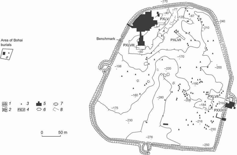
Fig. 1. Layout of the Kraskinskoye fortified settlement, indicating the location of Bohai cemetery (survey of 1995 corrected according to later measurements).
1 – earthwork; 2 – earthwork gap; 3 – stone base; 4 – excavation areas of 2011; 5 – excavation areas of 1980–2010; 6 – rock fill; 7 – pit;
8 – traces of structures revealed by prospection.
8th to the first third of the 10th century. The town’s name is probably associated with the name of Yanchihe (presentday Tsukanovka) River, running into Expedition Bay.
The Kraskinskoye cemetery is located in the neighborhood of the site, mainly south of it, along the coasts of the bay and the banks of the river. Excavations of the mounds have provided Jurchen materials attributed to the early 13th century (Raskopki pamyatnikov…, 1994: 251–333). Information about Bohai burials was first obtained in 2003 by Y.G. Nikitin, who accidentally discovered mason-work under turf in a layer of sand (without visible features on the daylight surface) 300 m west of the Kraskinskoye fortified settlement (Nikitin, Isao Usuki, 2004; Nikitin, 2009). In 2005, in the course of studies conducted by the expedition of the Institute of History, Archaeology and Ethnography of the Peoples of the Far East FEB RAS led by V.I. Boldin, a geomagnetic survey was performed in the vicinity of an excavated burial by E.A. Bessonova, a researcher of the Pacific Oceanological Institute FEB RAS. In 2007, the georadar technique was employed to search for other graves here, and preliminary results, requiring verification, were obtained.
In 2011, the International Russian-Chinese Expedition of the Institute of History, Archaeology and Ethnography of the Peoples of the Far East FEB RAS and the Jilin Province Institute of Archaeology conducted a drilling survey at the Kraskinskoye fortified settlement and in its neighborhood. Positive results were obtained both at the site and in the area around the grave discovered in 2003 (Gelman, Ivliev, 2013). The remains of another burial were found near it.
This article presents the results of comprehensive studies of the area comprising Bohai graves near the fortified settlement of Kraskinskoye (2005–2012). A comparative analysis of data obtained by different methods of searching for burials without visible features on the daylight surface has been conducted.
Archaeogeophysical studies
In 2005, in order to reveal flat burials of the Early Middle Ages (which are the hardest-to-find hidden historical and cultural heritage sites), an area of 900 m2 was explored by means of direct current electrical profiling M 1 : 200
and magnetic survey M 1 : 100 (Bessonova, Zalishchak, Valitov, 2005). The objects of interest are shallowly buried limited-size accumulations of large stones, which are not typical of flood-plain deposits in this area of the Tsukanovka River valley, and differ from the enclosing rocks in electrical conductivity and magnetic intensity. According to the results of petromagnetic studies of soft sediments and the stone material of burial enclosures, the magnetic susceptibility of rock-fragments brought by people is twice that of enclosing soil (Fig. 2, f , g ). However, the volume of stone material is small, and (taking into account the depth of its occurrence) only low-amplitude magnetic anomalies can be identified; therefore, the use of different geophysical methods is justified. In-plane coincidence of anomalously high values of electrical resistance and low-amplitude magnetic anomalies was used as a criterion for locating the objects of interest (Sholpo, 1977; Kortunov, Kulinich, Valitov, 1999). A low-amplitude magnetic anomaly, spatially coincident with a geoelectric one, has been revealed on the schematic maps of abnormal magnetic fields and electrical resistance. A distinguished local diagonalstrike area, compatible in size with the 3 × 5 m objects of interest (Fig. 3, 4), was subsequently explored by drilling technique, which proved to be successful. In microrelief, the position of the grave in plan corresponds to a small isometric prominence going northward beyond the burialenclosure (see Fig. 2, h ).
Taking into account the high informational contents of the petromagnetic studies of the cultural layer (Mullins, 1974; Clark, 1990: 132–162; Zalishchak, 2002; Linford, 2005; Arkheologicheskiye issledovaniya…, 2011: 175– 190; Bessonova, Gelman, Nikolaeva, 2013), kappametry of soft sediments was applied layer by layer on a 1 × 1 m grid within the entire excavated area of the burial, in accordance with the planigraphy of the excavations (see Fig. 2, a–e) (Dudkin, Koshelev, 2001). The distribution of the magnetic susceptibility of soil is characterized by well-defined areas of low and high values, with distinct boundaries for various strikes. The surface of the topsoil is distinguished by minimal values (see Fig. 2, a). Consistency is observed of magnetic susceptibility distributions on the soil’s surface and at the level of the fourth stratum (burial location) (see Fig. 2, d). Comparison of the results of the excavations and the distribution of the magnetic susceptibility of the topsoil’s surface has identified the correspondence between anomalously high values of the parameter under study and the position of the burial area in plan, as anticipated*. We relate this fact to different compositions of subsurface soil inside the grave and beyond its limits.
Archaeological studies
Results of prospection drilling. Drilling was carried out on the selected test site, on 3 × 3 m grid, until the location of mason-work was found, following which the outer and inner boundaries of the object were determined. The stratigraphy of the area was the following: turf-cover approximately 30 cm thick was underlain by a gray-brown sandy loam layer approximately 20 cm thick, which overlaid terrestrial sand deposits.
The grave was located in the layer of gray-brown sandy loam. Its edge was discovered at a depth of approximately 50 cm, and the bottom was traced at a depth of more than 1 m. The grave had a rectangular shape, and was oriented along a north-south line. It had a length of 470 cm and a width of 260 cm. The walls were composed of stones of various sizes and shapes. The thickness of walls reached 30–40 cm, the height was about 60 cm (Gelman, Ivliev, 2013).
Results of archaeological excavations. In August 2012, grave 2 was excavated by the Russian Expedition of the Institute of History, Archaeology and Ethnography of the Peoples of the Far East FEB RAS (led by E.I. Gelman). The excavations confirmed the results of prospection drilling, though slightly correcting them (see Fig. 4). In particular, it has been established that the grave is oriented according to cardinal points, and has a nearly rectangular shape. Its length is 390–410 cm from south to north, and the width is 320–350 from west to east. It is compatible in size with the stone structure of grave 1, excavated in 2003 (400 cm from north to south, and 340 cm from west to east), and with large graves at the Bohai cemetery of Hongzunyuchang (Heilongjiang province) in the People’s Republic of China (Ninan Khuntczuniuichan, 2009: 615). The inner part of grave 2 had a size of 240–280 cm from west to east and 300 cm from south to north. Masonry walls had a thickness of 15–20 cm and a height of 26–43 cm. The grave structure became apparent at a depth of 30–40 cm below the daylight surface, while stone foundations of walls were located at a depth of 60–70 cm. Obviously, the size of burial revealed by drilling differs from the actual one. This is because the number of drilling locations was limited to ensure the best integrity of the burial-structure.
During archaeological excavations, large stones of the grave’s masonry walls were exposed right after the removal of turf 23 to 30 cm thick. The average benchmark of the upper points of these boulders is 85 cm. Upon removal of the second stratum, it became evident that the largest stones were concentrated near the southern wall.
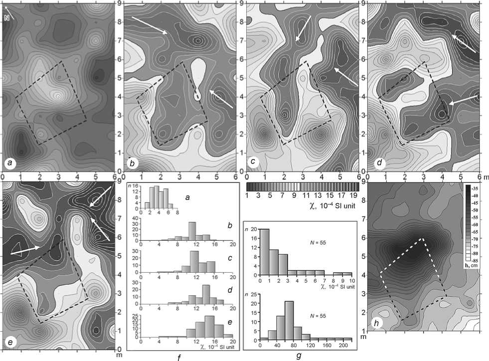
Fig. 2. Kappametry results.
a–e – schematic maps (M 1 : 100) of magnetic susceptibility of soil in the excavation area: a – topsoil surfaces; b , c , d , e – soil surfaces after removal of the 1st, 2nd, 3d, and 4th strata respectively; f – distribution histograms of magnetic susceptibility of soil surface (according to the planigraphy of excavations); g – distribution histograms of magnetic susceptibility of stone material; h – microrelief of the excavation area (daylight surface). Position of enclosure foundation in plan is shown by dashed line.
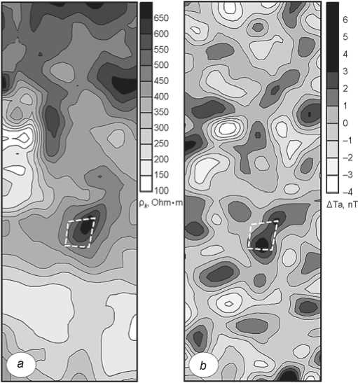
Fig. 3. Results of archaeogeophysical studies. a – distribution of apparent electrical resistance in a nearsurface layer; b – local positive magnetic anomalies. Location of burial is shown by dashed line.
0 10 m
0 1 m
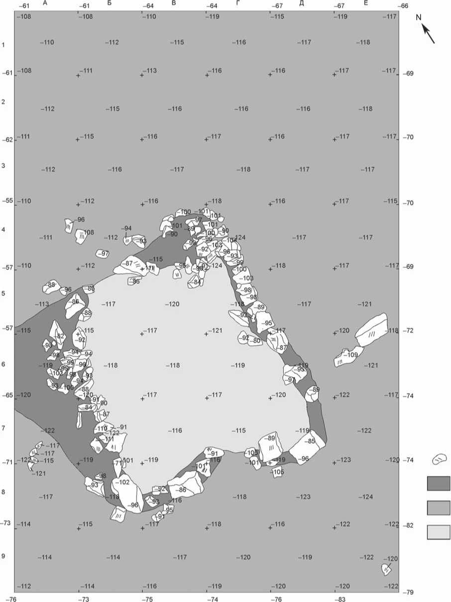
Fig. 4. Layout of grave 2.
1 – mason-work; 2 – grayish-brown sandy loam; 3 – brown uneven-grained sand; 4 – pale-brown fine-grained sand.
This permitted the assumption that the entrance into the burial facility was located exactly here. In the middle of the southern wall, there was an aperture 1 m wide, shaped by a large stone block on either side (40 × 40 and 50 × 40 cm). Another two similar stones were installed in the southern and eastern corners of the grave (50 × 34 and 60 × 36 cm). The eastern wall composed mainly of the average-sized stones was in better condition; the western and southern ones were most severely damaged as early as the Bohai period. The masonry structure of the grave was made of the same stone that was employed for construction and repair of the fort-walls of the Kraskinskoye settlement.
It has been determined that filling of the inner part of the burial is homogeneous, and consists of pale-brown fine-grained sand. On the outside of the stone cover, the main layer consists of brown uneven-grained sand. The masonry structure of the grave was arranged in compact grayish-brown sandy loam that is preserved along the burial boundaries, in the areas without stones. This layer has also been revealed in the course of drilling while determining the burial’s boundaries.
Six small fragments of Bohai wheel-thrown ceramicware, and a pawn in the form of a flat stone disk (Fig. 5), have been found during excavations. No remains of bones were discovered in this grave. The cultural layer turned out to be almost completely destroyed, presumably because of periodic flooding of the river and underground water activity, which resulted in the grave’s being filled with fine-grained sand. Kappametry data applied within the area of the burial confirm this presumption.
Thus, the grave type (availability of stone cover and sandy or earthen bottom), its shape and size are most typical of the Bohai burials (Liudinshan…, 1997: 18, 19, 126–129; Nikitin, 2009). Grave 1, excavated in 2003, is oriented with its long sides along a N-S line, while the entrance was located on the southern side and was shaped in a similar manner, by flat stone slabs. However, this grave was distinguished by thicker stone walls with a height of 74–90 cm, which imparted to it a certain resemblance with a crypt. Six rows of claybound stones have been traced in the mason-work of the northern wall (Nikitin, 2009). It should be noted that certain graves of the Bohai cemetery of Hongzunyuchang are oriented according to cardinal points, some of them have an entrance located on the southern side and often shaped by almost rectangular large stone slabs (Ninan Khuntczuniuichan, 2009: 615).
The absence of bones and funerary goods in graves is not unique. Empty graves and burials with a minimal number of finds were also discovered in the Bohai cemetery of Hongzunyuchang. Grave 1 of the Bohai group of burials near the Kraskinskoye fortified settlement contained only iron elements of belt set and a fragment of a wheel-thrown vessel. It is likely that the character of finds and arrangement of the burial (thickness and thoroughness of mason-work) point to a high status of the buried person.
Paleogeographic features
Cultural layer of the burial turned out to be completely destroyed, probably, eroded. This is explained by high flood water activity on the floodplain of the Tsukanovka River, which has been established from the results of excavations and geophysical survey of the Kraskinskoye fortified settlement (Bessonova, 2007; Bessonova, Gelman, Nikolaeva, 2013). The subsurface soil in the excavation area is represented by uneven-sized sandy deposits of derived silts from the floodplain elevation: inside the grave, sandy-aleuritic material is distinguished, and beyond the stone cover, irregular deposits composed of gravel and coarse-sand grains, medium- and finegrained sand, and aleurite. Many grains are covered with a thin iron film, and fissured. Fissures are filled with clay matter and iron oxides. Coarse aleuritic material is poorly preserved. Such condition of grains can be indicative of their arrival during erosion of the shallow areal weathering crust developed on granitoids, outcrops
Fig. 5. Artifacts discovered during investigations of grave 2.
1 – fragment of a wheel-thrown vessel rim; 2 – stone game-piece; 3 – wall of wheel-thrown vessel decorated with incised pattern.
of which are observed upstream of the Tsukanovka River. Differentiation of friable material beyond the limits and inside the grave was, most likely, formed as a result of filtration of suspended matter by the walls of burial structure.
The age of burial most likely corresponds to the medieval warming phase (1000–1300 BP), when the climate on the coast of the Peter the Great Gulf was more humid and warmer than nowadays. Sedimentation in the Tsukanovka River mouth proceeded in the shallow desalinated lagoon, with considerably increased volume of river run-off and flood water activity.
Distribution of the magnetic susceptibility of soil at various levels of the excavation area (see Fig. 2, b–e ) is determined by varying proportion of sand and clay particles formed according to microrelief. During floods, material with reduced content of clay particles, which is characterized by increased magnetic susceptibility, was deposited on the most elevated areas. This has made it possible to determine potential directions of arrival of friable material, shown by the arrows on the schematic maps (see Fig. 2, b–e ). On all maps, location of burial area in plan is marked by increased magnetic susceptibility values. Thus, burial was always expressed by a small mound in relief.
Conclusions
Study of the remains of Bohai grave 2 with a stone cover near the Kraskinskoye fortified settlement in 2012 has confirmed that, apart from the earlier known Kraskinskoye cemetery of the Jurchen period, a separate group of Bohai graves also existed here (Raskopki pamyatnikov…, 1994: 251–333). In terms of its arrangement, the unearthed grave is similar to many Bohai burials both at the Chernyatino-5 cemetery in Primorye and at Bohai burial grounds studied in China.
The excavations have largely confirmed the results of geophysical studies and prospection drilling. In the absence of visible features on the daylight surface, and with the availability of stone structures in the graves, alternative methods of archaeological exploration in the area under study are promising in terms of determining the boundaries of the Bohai cemetery and of separate burials, the relative depths of their locations, stratigraphy, etc. However, they can clearly not substitute for full-fledged archaeological excavations.
Mapping of the magnetic susceptibility of soil surface in the area where micromagnetic measurements and electrical profiling have already been performed appears to be promising in terms of the search for other burials. Most probably, kappametry of the soil surface within this territory can be employed subsequently as an independent method of searching for burials, which will make reconnaissance surveys considerably cheaper and increase their reliability.
Mapping of the magnetic susceptibility of subsurface soil has made it possible to establish that the formation of the upper part of the geological deposits took place in conditions of high floodwater activity; and to determine the directions of the arrival of suspended silts and, consequently, the directions of water-flow. Despite the destruction, the area of the Bohai graves’ discovery is undoubtedly promising for further investigations.
