The Kushevat site and the paleogeographic context of the initial peopling of Northern Urals

Author: Zolnikov I.D., Anoikin A.A., Kurbanov R.N., Filatov E.A., Zotkina L.V., Vybornov A.V., Postnov A.V., Parkhomchuk E.V., Filatova M.O.
Journal: Archaeology, Ethnology & Anthropology of Eurasia @journal-aeae-en
Article in issue: 2 т.51, 2023.
Free access
On the basis of new materials excavated in 2019–2021 from the Upper Paleolithic site of Kushevat, this study addresses the problem of initial human occupation of the Subpolar Urals. Geological and geomorphological fi ndings are presented along with new chronological and paleogeographical data. Archaeological and faunal materials are described, and result s of the traceological analysis of reindeer antlers with cut and chop marks are presented. The fi ndings suggest that Kushevat was a pioneer settlement of the northern Ob region. The obtained luminescence and radiocarbon ages suggest that the peopling of the Lower Ob region occurred prior to 30 ka BP. Climatic conditions during the fi rst half of the Upper Paleolithic (55–25 ka BP) were favorable for humans in the subpolar zone. Geological and geomorphological situation at the Upper Paleolithic sites of northwestern Urals (the Pechora and Kama basins) can be used as a paleogeographic analogue of the conditions in the Lower Ob region during the Pleistocene. The principal Upper Paleolithic sites in the region are associated with accumulations of megafaunal remains in the mouths of ancient gullies. Archaeological sites apparently consisted of two areas differing in location, economic specialization, and toolkit. Areas of the fi rst type include residential zones on leveled areas of the second river terraces adjacent to the ravines. Those of the second type are estuarine zones of modern valleys of streams and rivers, where huge accumulations of megafaunal remains are preserved at the bottoms of ancient ravines.
Northern urals, upper paleolithic, terminal late pleistocene, paleontology, paleogeography, traceology
Short address: https://sciup.org/145146881
IDR: 145146881 | DOI: 10.17746/1563-0110.2023.51.2.027-037
Text of the scientific article The Kushevat site and the paleogeographic context of the initial peopling of Northern Urals
The recent justification of the hypothesis that the northern West Siberian Plain was free from ice cover starting from ~50 ka BP (Astakhov, 2020: 356–357) suggest the fundamental possibility of human penetration into the lower reaches of the Ob River as early as after the Early Zyryanka glaciation (MIS 3). Formerly, a scarce Paleolithic-looking archaeological material collected in the valley of the Voikar River and on the banks of the flowing Lake Voykarsky Sor was an indirect evidence of the Late Pleistocene human habitation in the region (Kosinskaya, Fedorova, 1994: 36). Later, similar finds were made at the shoals of the right bank of the Lower Ob, along with numerous Pleistocene faunal remains, some of which showed signs of anthropogenic impact (Zolnikov et al., 2020; Zolnikov, Anoikin, Filatov et al., 2021) (Fig. 1). Among them, two fragments of tusks with cutting and scraping marks, with direct AMS ages of ≥45 ka BP, are of the greatest interest (Zolnikov, Anoikin, Rendu et al., 2021). These fragments suggest that early humans could have settled in the subpolar regions of the Ob River valley during the
period corresponding to the initial stage of MIS 3. The relatively recent discovery of stratified complexes in the Lower Ob region (the sites of Lugovskoye and Komudvany) showed younger 14C- and AMS-ages, within MIS 2 (Zenin et al., 2006; Makarov et al., 2022). The available data allow the distinguishing of two types of Paleolithic industries in the region: a microblade lithic industry at stratified sites, and a more archaic pebble industry (Makarov et al., 2021), which suggests the possibility of at least two stages of peopling of this region in the Pleistocene. However, until recently, there was no convincing evidence of human presence in the Lower Ob prior to the latest glacial maximum (LGM, MIS 2); available “archaic”-looking artifacts were collected mainly from the surface. Meanwhile, two reconnaissance trenches in the Pleistocene sediments at the Synya River (left tributary of the Ob) revealed solitary artifacts (Zolnikov, Anoikin, Filatov et al., 2021) (Fig. 1). In subaerial sediments at the Un-Soim locality, a shatter with negative scars was found in association with a small fragment of a tubular bone, for which two AMS ages were obtained: 34,228–32,372 (GV-3034) and 31,205–30,920 (AAR-33844) BP. The Yam-Gort-4 Pleistocene deposits yielded a blank of an unidentified tool, bearing multidirectional negative scars (Ibid.). A series of four OSL ages obtained in Aarhus University (Denmark) on soil samples from the section indicates that the age of the soil containing the artifact is ~60 ka.
The data from the studies at Kushevat discovered in 2020 (Ibid.) provide a more substantiated assumption about the early peopling of the northern part of the Ob valley in the Early Upper Paleolithic. This article presents the materials obtained at this site in the recent years, as well as general issues related to the topic of the pioneer human settlement of the region.
Kushevat
General information. The site is located at the eastern outskirts of the abandoned village of Kushevat, 5 km eastwards of the village of Gorki, on the right bank of
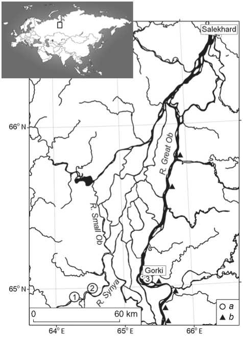
Fig. 1. Study region.
a – sites with in situ occurrence of archaeological materials (1 – Yam-Gort-4, 2 – Un-Soim, 3 – Kushevat); b – site of surface occurrences of artifacts and faunal remains.
the Kushevat channel of the Great Ob (Fig. 1). It is situated on the right side of the valley of a nameless stream flowing into the Kushevat channel, together with another stream forming a kurya — short and wide mouth filled with water during the spring-summer flood and almost drying up in the autumn-winter period (Fig. 2, 1 ). Initially, trenches were prepared on the left bank of the kurya in 2019 (Zolnikov, Anoikin, Filatov et al., 2021). In 2020, a bone from a Pleistocene bison and a small flake of light brown flint were found on the right bank shoal. Subsequently, the works continued at this site, and in 2020–2021, two excavation areas and 14 trenches with a total area of 72 m2 were established at the site (Fig. 3). The excavations reached the alluvial deposits of the Ob at a maximum depth of 3.7 m. Abundant faunal material and isolated archaeological finds were recorded in the layer of the ravine-gully solifluction-brook deposits underlying the subaerial cover.
Stratigraphy. The generalized column of the deposits represents a consolidated stratigraphic sequence in excavation trenches 1 and 2, located at a distance of 5 m from each other.
The profiles show numerous leanings, insets, envelopings, and facies replacements. The number of layers varies in different excavation areas; nevertheless, the layers can be combined into four stratigraphically consistent units, which have been traced in all the sections (Fig. 4).
Unit I — covering subaerial sediments . The uppermost stratum is modern forest soil 0.1–0.3 m thick. It is underlain by pale-brown silt, with sandy (up to silty sand) inclusions, and areas with thin and fine layering parallel to the slope. The origin of the unit is a subaerial cover with the thermokarst-puddle, eolian, diluvial, and solifluction processes. The bedding is enveloping. The thickness varies from 0.2 to 0.7 m, 0.3–0.4 m on average.
Unit II is mudflow (veloflux, i.e. fast soliflux). The deposits are gray silt with a brownish tint, with rare “smeared” sandy strips. Up to five or six layers were identified in the studied profiles; these layers vary
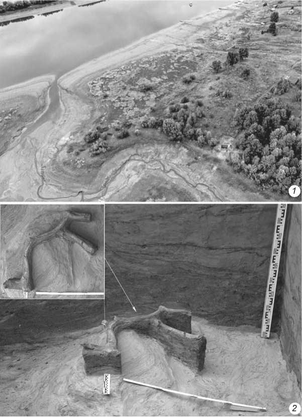
Fig. 2. The top view on the site of Kushevat ( 1 ); the conditions of occurrence of the reindeer antler with cut marks in excavation area 2 ( 2 ).
significantly in thickness from about 2 m to wedging out. In the bottom part of the layers, irregularities in the lower border were recorded with vertical amplitude of up to 1 m, which are textures of capture of the underlying sediments and their involvement in the liquid-mud flow. The common origin of the sediment unit is a series of fast solifluction flows. Similar drift deposits are typical of the subarctic regions and are narrow long fans of liquefied mud hundreds of meters long (Astakhov, 2020: 47; Lavrushin et al., 2015: 20). The unit fills the paleohollow of the ancient gully. The thickness is from 0.4 to 2.7 m .
Unit III—ravine-gully deposits. They include two main facies: 1) sands of creek alluvium with troughlike and plane-parallel oblique bedding; 2) solifluction
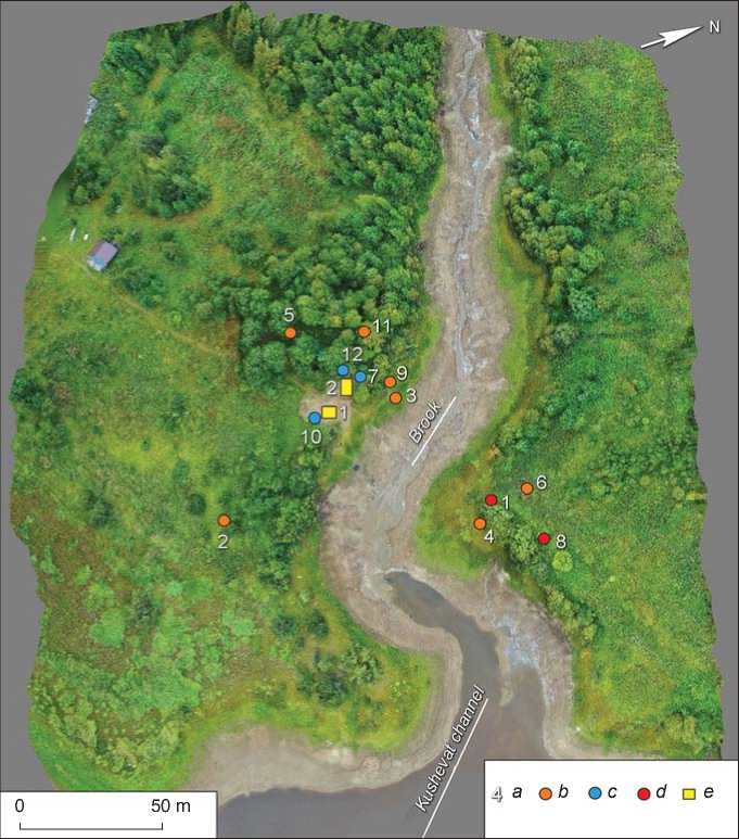
Fig. 3. Ortho-photo-map of Kushevat, with excavation areas indicated.
a – numbers of probe trenches and excavation areas; b , c – trenches of 2020 with faunal remains ( b ) and without them ( c ); d – trenches of 2021 without faunal remains; e – excavation areas of 2021.
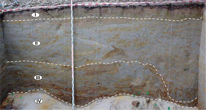
Fig. 4. Northern wall of excavation area 2, with the main sediment units indicated.
silts, which are mud deposits, slowly moving in a fluid state and deposited in paragenesis with crossbedded sands dragged by ravine alluvium. In contrast to the layers of unit II, each of which corresponds to an independent drifting event, the layers of unit III cannot be unambiguously subdivided into layers of different ages. This is due to the fact that ravine deposits are composed of fluvial and muddrifting interlayers, troughs, and oblique series that replace and cut one facies by another. The total thickness of the unit is from 2.2 m to complete wedging out. Faunal and archaeological materials were recovered from the near-bottom part.
Unit IV—the Great Ob alluvium. Well-washed light gray fine- to medium-grained sands deposited in parallel subhorizontal and oblique fine laminations, with ascending current ripple. The deposits stem from a typical alluvium of the Ob. The bottom has not been reached, but judging by the sands of this unit, which are exposed on the near-channel shoals of the Great Ob in this area, the thickness of this unit exceeds 3–5 m. The deposits represent alluvial stage II of the floodplain terrace of the Great Ob.
Chronology. The age of the deposits and the time of accumulation of the bone-bearing horizon were determined on the basis of optically stimulated luminescence (OSL), radiocarbon AMS analyses, performed in various laboratories both in Russia and abroad. Four samples for OSL-dating were collected from different lithological units in trench 7 (Fig. 5). Sample preparation was carried out in the OSL-dating laboratory of the Moscow State University and Institute of Geography RAS; and sample measurement in the Aarhus University. The uppermost part of unit IV (depth 230 cm) was dated to 57.9 ± 4.1 ka BP (lab. code 206186), which suggests the age of the top of alluvium II of the floodplain terrace of the Ob as ~60 ka. Date 39.8 ± ± 2.4 ka BP (206187) for unit III (depth 185 cm), which includes a bone-bearing horizon, reflects the time of accumulation of ravine-gully alluvium in the estuarine section of the kurya . The date of 31.1 ± ± 2.3 ka BP (206188) was obtained for the near-bottom part of unit II overlying the abovementioned deposits (depth 175 cm), and 22.6 ± 1.2 ka BP (206189) for the middle portion (depth 130 cm) thereof . These ages indicate the start of accumulation and further development of the process forming the subaerial cover of terrace II. Notably, the series of ages forms a continuous sequence without inversions, and fairly accurately reflects the main stages of accumulation
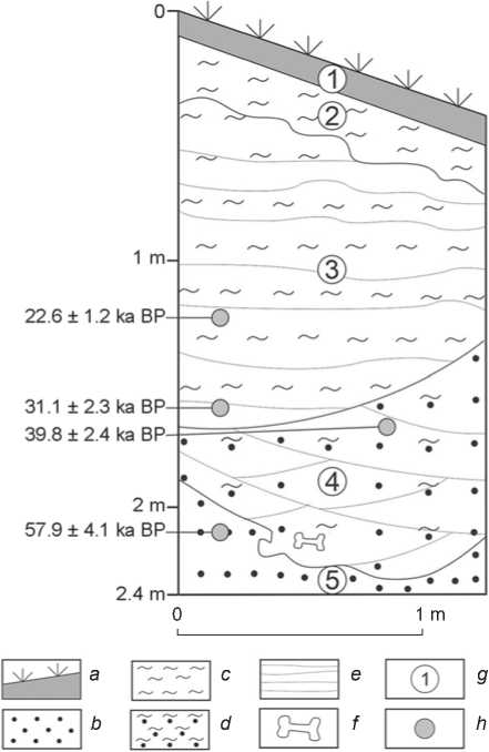
Fig. 5. Stratigraphic column of the northern wall of trench 7 (2020).` a – modern soil; b – sand; c – aleurite; d – silty sand; e – bedding; f – paleofaunal remains; g – numbers of layers; h – places of sampling for OSL-dating.
of Ob terrace II in the site area. This series is in good agreement with the data of 14C AMS-analysis of the faunal remains from the bone-bearing horizon in unit III. A total of four dates were generated in the laboratories for AMS-dating at Aarhus University (AAR) and the AMS Golden Valley (GV). The ages were calibrated in OxCal, v. 4.4.4., using the IntCal20 calibration curve (Muscheler et al., 2020), with a reliability rate of 95.4 %. For reindeer antlers with traces of anthropogenic impact, two close dates were obtained: 40.1 ± 0.7 (GV-3112) and 38.1 ± 0.9 (AAR-33845) ka BP. A slightly younger age was received for another fragment of a deer antler and a fragment of a mammoth’s tubular bone: 29.7 ± 0.4 (AAR-33846) and 32.1 ± 0.6 (AAR-33847) ka BP, respectively. Consequently, the age of accumulation of animal remains in lithological unit III is 40–30 ka BP.
Faunal remains. The bone-bearing horizon lies at the bottom of unit III, at a depth varying from 1.5
to 3.5 m depending on the area. Its mean thickness is 0.20–0.25 m. Analysis of the stratigraphic sequence shows that the bone-bearing layer extends in a narrow (up to 10 m wide) band along the right side of the Kushevat kurya , and its total area does not exceed 1000 m2.
In total, 130 bone remains were recovered, including 53 specimens identifiable to a species (identifications made by S.K. Vasiliev). More than a half of the bones belong to the reindeer ( Rangifer tarandus ); these are bones of the limbs, cervical spine, and fragments of the skull, including antler. Mammoth remains ( Mammuthus primigenius ) form the second largest group (11 spec.): cervical vertebrae, metatarsal bones, and tusk fragments. The ribs of woolly rhinoceros ( Coelodonta antiquitatis ) and bison ( Bison bison ) were recorded in small numbers. Solitary bones of musk ox ( Ovibos moschatus ), horse ( Equus sp .), wolf ( Canis lupus ), and hare ( Lepus tanaiticus ) were also found. It should be noted that the predominance of reindeer bones in faunal collection distinguishes Kushevat from the sites of the West Siberian Plain, belonging to the late stages of the Upper Paleolithic, such as Lugovskoye, Komudvany, Shestakovo, etc., where mammoth remains dominate, accounting for up to 95 % of the collection (Derevianko et al., 2003: 120–127; Zenin et al., 2006; Makarov et al., 2022).
Anthracological analysis data . In the bonebearing horizon, along with the faunal remains, more than ten pieces of charcoal were found, with sizes and states of preservation allowing anthracological analysis to be conducted. We selected 11 samples, ranging in size from 2 × 4 to 3 × 14 mm. Macroscopic signs of transverse, tangential, and radial sections of charcoal were studied in reflected light using the Axio Imager D2 microscope and Stemi 508 binocular with an AxioCam HRc 5 camera (Carl Zeiss). Species identification was carried out by comparing the diagnostic structures with the keys of the atlas “Anatomy of Russian Woods” (Benkova, Schweingruber, 2004).
The analysis has shown that six samples belong to deciduous species (Dicotyledones sp.), more detailed definition is not available; four samples belong to common pine (Pinus sylvestris L.); and one sample to silver birch (Betula pendula Roth). All the types of woody plants correspond to the forest-forming species of the northern taiga. These data indicate that the anthracological analysis did not show any fundamental differences between the environmental conditions that existed during the accumulation of the bone-bearing horizon at the site and the modern ones.
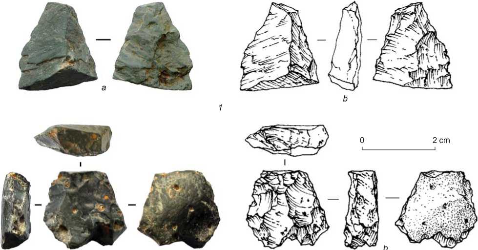
Archaeological materials. In the bone-bearing horizon, in excavation area 2A, a small fragment of spall of gray silicified shale rock (Fig. 6, 1 ) and a small, heavily exhausted core retaining the straight striking-platform bearing lengthwise scars of elongated rectangular removals (Fig. 6, 2 ) were found. The artifacts were made on small pebbles of silicified sedimentary rock of dark gray color. Notably, the artifact-bearing sediments contained almost no detrital material. Rock fragments were noted only in thin lenses of grus, which included very small weakly rounded fragments of slates, granites, and quartz.
Traceological analysis data. Use-wear analysis of the faunal remains revealed the signs of anthropogenic impact on two reindeer antlers. The specimen from trench 12 shows a series of deep linear marks, suggesting deliberate cutting of an antler on one of its parts (Zolnikov, Anoikin, Filatov et al., 2021).
In 2021, in excavation area 2, another piece of antler was found, a larger one, broken into several fragments (see Fig. 2, 2 ). These show clear, well-preserved, and rather deep cut marks, predominantly V-shaped in side view (Fig. 7). In most cases, the groove in the central part is deeper than on the periphery, the marks are not long and are localized in the areas of the antler’s fragmentation, suggesting their interpretation as traces of chopping with a sharp tool. Traces similar in morphology and localization were recorded on deer antlers from several Upper Paleolithic sites in Eastern Europe and Siberia (Volkov, Vasiliev, 2017: Fig. 2, a , d ; Mazza et al., 2022: Fig. 18). Noteworthy are the missing lateral processes and splitting of the antler into large fragments; this may be due to the deliberate preparation of blanks of a certain size (Tapia et al., 2018: Fig. 4). These observations, together with the straight edges of the broken parts and the availability of vivid cut-marks on the margins, indicate the purposeful splitting of antlers by man.
Discussion
The materials from the site of Kushevat and the results of absolute dating, derived through various methods in several laboratories, suggest that it was the location of pioneer human settlement in the Lower Ob
а
Fig. 6. Flake ( 1 ) and core ( 2 ) from Kushevat. a – photo; b – drawing.
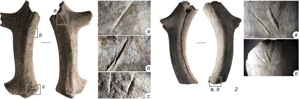
Fig. 7. Fragments of reindeer antler from excavation area 2 and macrophoto of chop marks on them.
Magnification: 1 , a , b , c – ×16, ×12.5 and ×12.5, respectively; 2 , a , b – ×16 and ×8, respectively; 3 , a – ×32; 4 , a – ×8.
region. However, the discovered artifacts are scarce and do not provide a good insight into the material culture of the first settlers, even in general terms. The following inferences can be proposed on the basis of the paleogeographical situation at the site, which is reconstructed from analyses of numerous geological sections. The bone-bearing horizon, presenting evidence of human habitation, is associated with ravine-gully deposits of a paleoravine covered by a thin subaerial layer. The camp of prehistoric humans was obviously located not in the ravine, but on the second terrace above the floodplain. At the same time, it could not have been situated at a great distance from the excavated area, since the bone-bearing horizon contained rather large charcoal fragments that would have been destroyed during long-term transportation. Such localization of the main habitat close to the area of concentration of faunal remains (where archaeological materials could be occasionally imported), but at a higher hypsometric level, is not unusual and is well-illustrated by recent discoveries at the site of Volchya Griva (Leshchinskiy, Zenin, Bukharova, 2021).
Many Paleolithic sites of Western Siberia are associated with accumulations of megafauna remains, which were not directly connected with human activities. Here, in the conditions of shortage of high-quality lithic raw materials, bones were often the only alternative. Furthermore, available ages for the Upper Pleistocene faunal remains from the Lower Ob and the analysis of their species composition suggest that during the second half of the Terminal Late Pleistocene (MIS 3) the fauna actually remained unchanged here (Zolnikov, Anoikin, Rendu et al., 2021).
Notably, the climatic conditions during the first half of the Upper Paleolithic (55–25 ka BP) were quite favorable for humans in the subpolar zone (Pervonachalnoye zaseleniye…, 2014: 428). The sizes of bison and mammoth populations in the Siberian Arctic in the range available for radiocarbon dating show that the period of ~45– 35 ka BP presented the optimal conditions for habitation (Nikolsky, Pitulko, 2015). During this period, corresponding to MIS 3, the Ural Range was not an insurmountable barrier to the migrations of early humans (Zolnikov et al., 2020); it seems quite feasible to consider the inhabitants of the northeastern margin of the East European Plain as potential participants of the initial peopling of the Trans-Urals. According to available data, the first human penetration into the basin of the Lower Pechora occurred ~40 ka BP (Pavlov, 2015). Accordingly, the geological and geomorphological features of the sites of this time in the Northern Cis-Urals can be considered parallel to the paleogeographic conditions of human habitation in the Lower Ob region in the Pleistocene.
According to available data (Pervonachalnoye zaseleniye…, 2014: 143), the sites of the initial
Upper Paleolithic in the Cis-Urals are located at the mouth areas of large ravines; this feature is also typical of the chronologically close sites in the central regions of the East European Plain. Meanwhile, the younger Paleolithic sites are located mainly in the central parts of river bends. Usually, in the estuarine areas of ancient ravines, there are kuryas —bays deeply cutting into the bank of a large modern river. In this regard, Mamontovaya Kurya is of particular interest, being the northernmost and the oldest site of the initial Upper Paleolithic in the Cis-Urals, located on the left bank of the Usa River (a tributary of the Pechora). According to a series of 14C- and OSL-dates, its age is estimated in the range of 35–40 thousand years (Ibid.). In total, 123 bone remains, mainly those of mammoth, horse, reindeer, and wolf, were found at the site. The archaeological collection included a side-scraper, a biconvex biface, and a mammoth tusk with traces of anthropogenic impact (Svendsen, Pavlov, 2003). All the finds were deposited in sand and gravel sediments up to 1.4 m thick, localized in an ancient wide and short ravine and overlain by a six-meter thick alluvium of the “big river” (Pervonachalnoye zaseleniye…, 2014: 105). Apparently, the Paleolithic site itself was located on a watershed plain near the ravine. Notably, similar paleo-incisions of various depths and widths are characteristic of the Lower Ob region (Zolnikov, Anoikin, Rendu et al., 2021). Some of them are associated with modern short valleys of tributaries of large rivers and dry ravines, at the mouths of which megafaunal remains and single artifacts have accumulated. Comparisons of the materials of Mamontovaya Kurya and Kushevat show that these sites are similar in almost all parameters.
A similar geological and geomorphological situation is observed at the Byzovaya site. This site is also located at the mouth of a large ravine, cutting through the steep bank of the Pechora. About 300 artifacts of the Upper and Middle Paleolithic appearance and over 4000 animal bones (mammoth bone share is 98 %) were found here. These occurred in sandy-gravel-pebble deposits, which lined the bottom of the ancient ravine with a two-meter layer (Pavlov, 2015) and were covered by subaerial sediments of several generations, with a total thickness of up to 10 m. Culture-bearing deposits were formed by several washes, which is evidenced by the spread of 24 radiocarbon dates on bone in the range of ~34–28 ka BP (Ibid.).
Unlike Mamontovaya Kurya and Byzovaya, which are striking examples of Paleolithic sites at mammoth “cemeteries”, Zaozerye is actually a site of ancient hunters with three accumulations of cultural remains associated with hearths, apparently marking living zones. The site is located on the left bank of the Chusovaya River (a tributary of the Kama), on a promontory bounded by large ravines. The proposed area of the site is >2.5 thousand m2 (Pavlov, 2009). The cultural layer, up to 45 cm thick, lies under a loess cover 2.5–3.5 m thick and is associated with the middle part of the Bryansk paleosol. It contained about 1500 faunal remains, of which >80 % are identifiable as horse remains. The archaeological materials (~1800 artifacts) include a large collection of Upper Paleolithic tools (bifaces, scrapers, burins, and others) and bone artifacts, as well as flakes and single subprismatic cores. The radiocarbon analysis suggests the age of the cultural layer as 33–35 ka, the OSL dating provided the age of ~40 ka (Ibid.).
The upper cultural horizon of the Garchi I site, located on a plain area bounded by broad incisions, on the right bank of the Kama, has been attributed to the Early Upper Paleolithic (Pavlov, 2011). The proposed area of the site exceeds 2000 m2. The cultural layer, ~20 cm thick, occurs at a depth of 2 m and is associated with paleosol. Its age, according to the available AMS- and OSL-dates, is ~33 thousand years. Almost all identifiable remains of fauna belong to horse and reindeer. The archaeological collection contains ca 9000 artifacts (including surface finds) attributed to the Upper Paleolithic Kostenki-Streletskaya culture. The site is believed to be a repeatedly used hunting camp, with a full production cycle of tool manufacturing (Ibid.).
In sum, the sites of the initial Upper Paleolithic in the north of the Pechora Plain are located mainly at kuryas , i.e. at the mouths of wide ravines flooded in spring, where streams and small rivers (tributaries of large rivers of the Cis-Urals) flow. The available materials testify that these ravines were “cemeteries” of large gregarious mammals, and were visited by early humans for butchering animal carcasses and collecting bone raw materials; the living zones proper were located on the nearby level grounds.
Such accumulations of megafaunal remains localized in broad short paleoravines on the Russian Plain are attributed to the episodes of extreme mudflow sedimentation, during which the mud flew with the greatest speed in the mouth parts of the gullies (Lavrushin et al., 2015: 15). Thus, these landforms could have served both as natural shelters from bad weather for large mammals, and as natural traps during prolonged downpours. Animals could die not only because of mudflows, but also as a result of outpourings of high-density flows of quicksand from lateral parts of the loess-soil cover, forming the gentle banks of ancient ravines. In the north of the region, during the climate warmings in the Subarctic, a significant role was played by the focal process of slope denudation of the “baydzharakh type”, producing steep slopes of the southern exposure, composed of ice-saturated rocks. During melting of underground ice and frozen rocks, powerful flows of liquefied silty mass emerged, which attracted (lithophagy) animals, but also killed them.
Conclusions
The analysis of the available geoarchaeological data for the Northern Cis-Urals has shown that the Upper Paleolithic sites in this region are associated mainly with large accumulations of paleofaunal remains, located at the mouth parts of ancient ravines/gullies, which in the modern relief are presented by the succeeding kuryas. The relevant archaeological sites usually consist of two areas with different locations, economic purposes, and material finds. Areas of the first type include residential and utility zones, located on the level grounds of the second terraces directly adjacent to the kuryas. These zones can occupy large areas and show significantly thick cultural deposits, retain traces of dwelling structures and hearths, and reveal rich archaeological material reflecting several stages of stone and organic material processing. Those of the second type are zones located in the mouths of modern stream and river valleys, where at the bottoms of the ancient gullies we find the accumulations of remains of large gregarious mammals that died in shelter-traps. The bones may bear traces of human impact, and be accompanied by scarce artifacts associated with butchering of animal carcasses and procuring horn, tusk and other organic materials. Zaozerye and Garchi I sites are examples of the areas of the first type, while Mamontovaya Kurya, Byzovaya, and Kushevat sites represent second type. Both types have been identified at the Lugovskoye location, where on the high bank of the ravine rich archaeological material was found, and below there was a flooded ground with an accumulation of paleofaunal remains, containing solitary artifacts and traces of hunting/ butchering (fragments of a side-bladed point in a mammoth vertebra) (Zenin et al., 2006; Makarov et al., 2021). Detection of possible dwelling areas associated with a bone accumulation site is often hampered by the geomorphological situation (for example, at Mamontova Kurya or Kushevat), since the thickness of deposits overlying the cultural layers at the site depends on the local geological and geomorphological conditions, as well as on the ratio between the processes of aeolian-diluvial accumulation and denudation. It can range from one to over ten meters.
The results of recent works at Kushevat have shown the undoubted peopling of the Lower Ob region prior to 30 ka BP, and suggested that it was a pioneer settlement in Northwestern Siberia. The general geomorphological situation at the site and its comparison with the data from other sites in the Northern Cis-Urals suggest that within the ancient ravine, along with solitary artifacts, a settlement complex with abundant archaeological materials can be found, which is buried in the second terrace of the Ob and covered by thick (up to 10 m) unit of subaerial sediments.
Acknowledgements
The study was supported by the Russian Science Foundation (Project No. 22-17-00140).
References The Kushevat site and the paleogeographic context of the initial peopling of Northern Urals
- Astakhov V.I. 2020 Chetvertichnaya geologiya sushi: Uchebnoye posobiye. St. Petersburg: Izd. SPb. Gos. Univ.
- Benkova V.E., Schweingruber F.H. 2004 Anatomy of Russian Woods. Bern: Haupt. (In English and Russian).
- Derevianko A.P., Molodin V.I., Zenin V.N., Leshchinskiy S.V., Mashchenko E.N. 2003 Pozdnepaleoliticheskoye mestonakhozhdeniye Shestakovo. Novosibirsk: Izd. IAET SO RAN.
- Kosinskaya L.L., Fedorova N.V. 1994 Arkheologicheskaya karta Yamalo-Nenetskogo avtonomnogo okruga. Yekaterinburg: UrO RAN.
- Lavrushin Y.A., Bessudnov A.N., Spiridonova E.A., Kuralenko N.P., Nedumov R.I., Kholmovoi G.V. 2015 Paleozoologicheskiye katastrofy v pozdnem paleolite tsentra Vostochnoy Yevropy (osnovy sedimentologopaleozoologicheskoy kontseptsii vozniknoveniya kladbishch mamontov). Moscow: GEOS.
- Leshchinskiy S.V., Zenin V.N., Bukharova O.V. 2021 The Volchia Griva mammoth site as a key area for geoarchaeological research of human movements in the Late Paleolithic of the West Siberian Plain. Quaternary International, vol. 587/588: 368–383.
- Makarov S.S., Zolnikov I.D., Anoikin A.A., Rezvyi A.S., Postnov A.V., Vybornov A.V. 2021 Osvoyeniye Nizhnego Priobya v pozdnem pleistotsene po arkheologicheskim dannym. Vestnik Novosibirskogo gosudarstvennogo universiteta. Ser.: Istoriya, filologiya, vol. 20. No. 5: Arkheologiya i etnografi ya: 43–54.
- Makarov S.S., Zolnikov I.D., Rezvyi A.S., Anoikin A.A., Zenin V.N., Leshchinskiy S.V., Vasiliev A.V. 2022 Komudvany—a Final Paleolithic Site in the Lower Ob Valley: Geomorphology, Paleontology, Archaeology. Archaeology, Ethnology and Anthropology of Eurasia, vol. 50 (1): 29–38.
- Mazza P.P.A., Stefaniak K., Capalbo C., Cyrek K., Czyzewski Ł., Kotowski A., Orłowska J., Marciszak A., Ratajczak-Skrzatek U., Savorelli A., Sudoł-Procyk M. 2022 Taphonomic analysis of the MIS 4–3 (Late Pleistocene) faunal assemblage of Biśnik Cave, Southern Poland: Signs of a human-generated depot of naturally shed cervid antlers? Quaternary International, vol. 633: 52–79. URL: https://doi.org/10.1016/j.quaint.2021.10.008.
- Muscheler R., Adolphi F., Heaton T.J., Ramsey C.B., Svensson A., Plicht J., van der, Reimer P.J. 2020 Testing and improving the IntCal20 calibration curve with independent records. Radiocarbon, vol. 62 (4): 1079–1094.
- Nikolsky P.A., Pitulko V.V. 2015 Vremennaya dinamika chislennosti bizonov Zapadnoy Beringii v pozdnem pleistotsene i nachale golotsena. In Fundamentalniye problemy kvartera, itogi izucheniya i osnovniye napravlenyia dalneishikh issledovaniy. Irkutsk: Inst. geografi i SO RAN, pp. 335–336.
- Pavlov P.Y. 2009 Stoyanka Zaozerye – pamyatnik nachalnoy pory verkhnego paleolita na severo-vostoke Yevropy. Rossiyskaya arkheologiya, No. 1: 5–17.
- Pavlov P.Y. 2011 Stoyanka Garchi I – pamyatnik kostenkovsko-streletskoy kultury na Verkhney Kame (Severniy Ural). Arkheologicheskiye vesti, iss. 16: 19–28.
- Pavlov P.Y. 2015 O pervonachalnom zaselenii severa Urala. Uralskiy istoricheskiy vestnik, No. 2: 50–60.
- Pervonachalnoye zaseleniye Arktiki chelovekom v usloviyakh menyayushcheisya prirodnoy sredy: Atlas-monografi ya. 2014 Moscow: GEOS.
- Svendsen J.I., Pavlov P. 2003 Mamontovaya Kurya: An enigmatic, nearly 40 000 years old Paleolithic site in the Russian Arctic. In The Chronology of the Aurignacian and of the Transtional Technocomplexes, J. Zilhão, F. d’Errico (eds.). Lisboa: UISPP, pp. 109–120.
- Tapia J., Alvarez-Fernandez E., Cueto M., Portero R., Becares J., Jorda-Pardo J.F. 2018 Bone industry of the Lower Magdalenian in Cantabrian Spain: The square-section antler points of El Cierro Cave. Quaternary International, vol. 472: 13–22.
- Volkov P.V., Vasiliev S.K. 2017 Nakhodki ostatkov megafauny so sledami vozdeistviya paleoliticheskogo cheloveka na yugo-vostoke Zapadno-Sibirskoy ravniny. Vestnik Novosibirskogo gosudarstvennogo universiteta. Ser.: Istoriya, filologiya, vol. 16. No. 7: Arkheologiya i etnografi ya: 66–73.
- Zenin V.N., Leshchinskiy S.V., Zolotarev K.V., Grootes P.M., Nadeau M.-J. 2006 Lugovskoe: Geoarchaeology and culture of a Paleolithic site. Archaeology, Ethnology and Anthropology of Eurasia, No. 1: 41–53.
- Zolnikov I.D., Anoikin A.A., Filatov E.A., Vybornov A.V., Vasiliev A.V., Postnov A.V., Zotkina L.V. 2021 New evidence of the Late Neopleistocene peopling of the Lower Ob Valley. Archaeology, Ethnology and Anthropology of Eurasia, vol. 49 (1): 9–20.
- Zolnikov I.D., Anoikin A.A., Makarov S.S., Postnov A.V., Rezvyi A.S., Glushkova N.V., Bychkov D.A., Tupakhin D.S., Vybornov A.V. 2020 O vozmozhnykh putyakh migratsii cheloveka na territoriyu Nizhnego Priobya v kamennom veke. Stratum Plus, No. 1: 137–146.
- Zolnikov I.D., Anoikin A.A., Rendu W., Filatov E.A., Makarov S.S., Rezvyi A.S., Postnov A.V., Brusnitsyna A.G., Vasiliev A.V., Vybornov A.V., Arzhannikov M.A., Zotkina L.V. 2021 Chelovek i mamontovaya fauna na severe Obi v pozdnem neopleistotsene. Stratum plus, No. 1: 39–56.
