The Peopling of Uzbekistan by Homo sapiens Denisovan

Author: Derevianko A.P.
Journal: Archaeology, Ethnology & Anthropology of Eurasia @journal-aeae-en
Section: Paleoenvironment, the stone age
Article in issue: 1 т.53, 2025.
Free access
This study continues a series of articles published in two last issues of this journal, exploring the split of the ancestral species H. heidelbergensis ~400 ka BP in the Levant and the subsequent origin of two filial species, Neanderthals and Denisovans. Certain members of H. heidelbergensis had moved to Europe, where a new taxon, H. s. neanderthalensis, emerged 200–150 ka BP. Others had migrated to Central Asia via Iran ~400–350 ka BP. Their assimilation of native populations of H. erectus, adaptation to changing environments, and natural selection led to the emergence of H. s. denisovan. In Uzbekistan, no Early Paleolithic sites are known. Based on archaeological evidence, one can presume that this territory was first peopled by Denisovans, who had migrated there from Tajikistan during MIS 6. At the final stage of the Karatau culture in Tajikistan, associated with pedocomplex 4 (MIS 11), new elements appeared in primary lithic reduction, types of stone tools, and the ways they were fashioned. In Uzbekistan, excavations of two key sites, Kulbulak and Obi-Rakhmat, have been ongoing for over five decades. Owing to long stratigraphic sequences, the evolution of the Middle Paleolithic industry of Denisovans has been traced over a long period spanning MIS 7–3. The only cave site excavated in Central Asia to-date, is Teshik-Tash in Uzbekistan, where Neanderthal fossils were found together with a Mousterian industry.
Early, Middle, Upper Paleolithic, H. erectus, H. heidelbergensis, H. neanderthalensis, H. denisovan
Short address: https://sciup.org/145147241
IDR: 145147241 | DOI: 10.17746/1563-0110.2025.53.1.003-024
Text of the scientific article The Peopling of Uzbekistan by Homo sapiens Denisovan
The early stage of peopling of Uzbekistan by Homo sapiens denisovan
The lack of information on Early Paleolithic sites in Uzbekistan is the result of insufficient archaeological studies of this area. The Pleistocene environmental and climatic conditions were beneficial for hominin dispersal. Early Paleolithic sites have been recorded in the adjacent regions of Tajikistan and Kazakhstan. Kulbulak, the oldest site in the territory of Uzbekistan, was initially attributed to that period. The site was discovered in 1972 and studied for many years by M.R. Kasymov, a talented Uzbek archaeologist (1972, 1973, 1990a, b; Kasymov, Tetyukhin, 1981; Kasymov, Godin, 1982a, b, 1984; Kasymov et al., 1985; Kasymov, Godin, Khudaiberdiev, 1992; etc.). In 1994– 1995, the site was excavated by the Joint Uzbek-Russian
Archaeological Expedition headed by U.I. Islamov and N.K. Anisyutkin (Anisyutkin et al., 1995). In 2001–2002, excavations were conducted here under the direction of U.I. Islamov (Islamov, Krakhmal, Ergashev, 2003). Since 2007, the site has been studied by the Joint Multidisciplinary Archaeological Expedition organized by the Institute of Archaeology and Ethnography of the Siberian Branch of the Russian Academy of Sciences (SB RAS) and the Institute of Archaeology of the Uzbekistan Academy of Sciences.
The site of Kulbulak is located on a high terrace of the southeastern slope of the Chatkal Range, on the right bank of the Akhangaran River. The surface of the terrace is heavily eroded and fissured into sections. The terrace is cut by two watercourses: the seasonal Dzharsay flows into the Kyzylalma River, a right tributary of the Akhangaran River. The Paleolithic site
Kulbulak is a unique site: in the course of the long-term works, M.R. Kasymov excavated a multimeter trench in the loose sediments. In one of the excavation sections, the researchers reached a depth of 19 m below the surface. Owing to the hydrological conditions in the area, groundwater rises and floods some parts of the excavation trench in rainy years. Kasymov identified 121 lithological units (layers and interlayers) in the 19-meter thick soft sediments (1990a, b). The total excavation area at Kulbulak is 600 m2; the depth of 19 m was reached only in a small test pit of about 2 m2.
In the cultural-historical sequence of sediments at Kulbulak, Kasymov identified 49 culture-bearing horizons, which he classified into stages. He attributed the materials from the low cultural layers (49–24) to the Acheulean, and the time of their accumulation to the Nanai period (the first half of the Middle Pleistocene); layers 23–13 to the Early Mousterian (formed during the Tashkent period—the second half of the Middle Pleistocene); layers 12–6 to the Middle and layers 5 and 4 to the Late Mousterian; layers 3–1 to the Upper Paleolithic (Kasymov, 1990a).
Some researchers have expressed doubts that the stratigraphic sequence of the Kulbulak was undisturbed (Ranov, Nesmeyanov, 1973; Nesmeyanov, 1978). They pointed to the possibility of Paleolithic artifacts sliding down from workshop sites located up the slope into the underlying layers either through the Dzharsay watercourse or by mudflows.
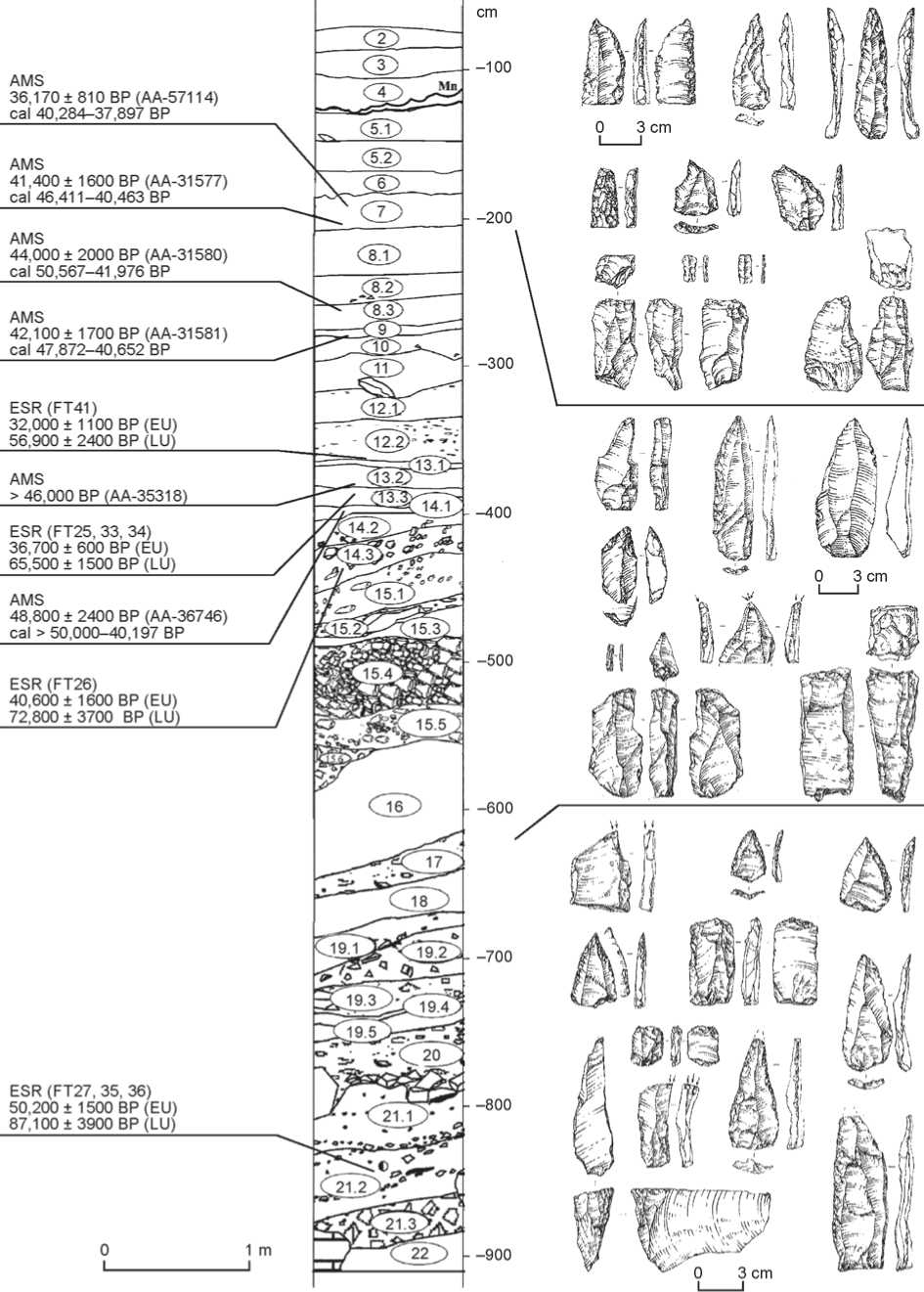
In 2007, a new stage of excavations at Kulbulak was carried out by the research team of the Institute of Archaeology and Ethnography SB RAS together with researchers from the Institute of Archaeology of the Uzbekistan Academy of Sciences (Derevianko, Kolobova, Flas et al., 2007). In the driest years (2007– 2018), archaeologists managed to penetrate into the thickness of loose sediments to a depth of 22 m, identify the lowermost cultural layers, and reconsider the entire stratigraphic sequence at the site (Fig. 1). As a result of comprehensive studies, four main sedimentary units, representing various paleogeographic conditions of the sequence accumulation, and 24 cultural layers were established (Taratunina et al., 2020).
Unit 1 comprises layers 25–22. The lowermost layer was uncovered at a depth of 22 m. The unit is composed of loam with numerous inclusions of debris and small rubble. The researchers suggest the existence of a small water reservoir during the accumulation of this unit; abundant inclusions of rubble in the form of separate layers indicate the involvement of mudflow processes in sedimentation (Ibid.: 279). The terminal stage of the unit formation is marked by the activation of mudflows and erosion signs between layers 23 and 22. This unit is dated to the period corresponding to the second half of MIS 7.
Unit 2 comprises layers 21–18. It shows the alternating proluvial-mudflow sediments, with thin interlayers of lacustrine loams of gray and bluish color. These deposits were formed during the cooling period of MIS 6.
Unit 3 includes layers 17–12. The upper part of the unit shows alternating layers of loess-like loam and thick horizons of proluvial-mudflow deposits, which generally reflect the repeated fluctuations of climate and environmental settings in the region. The loesslike loam of layer 16 is dated to 111 ± 19 ka BP (UG-7094) (Pavlenok K.K., 2020).
The uppermost unit includes layers 11–1. It was formed under the strong influence of slope processes and mudflows of varying intensity (Pavlenok K.K. et al., 2018). The upper part of layer 12, as well as layers 11 and 10, correspond to the cold period of MIS 4 (Taratunina et al., 2020: 279). The stratigraphic sequence of Kulbulak demonstrate thin soil layers. Some culture-bearing layers of the site were significantly destructed by heavy mudflows.
Thus, the second stage of the Kulbulak field studies provided the data suggesting a different historical and cultural stratigraphic column confirmed by biostratigraphic and geochronological findings; additional layers were identified below the 19-meter mark, which was not possible for Kasymov owing to hydrological conditions in the area of the site. Layers 23 and 24 yielded lithic artifacts suggesting a different interpretation of the Kulbulak lithic industry as a whole.
Layer 24 was formed as a result of diluvial and minor aeolian processes involving groundwater. The layer thickness reaches 1.9 m. Researchers noted that archaeological materials were concentrated mainly at the depth of 20.60 m. Solitary artifacts were recovered above this mark. The total number of stone implements is 1761 pieces (Pavlenok K.K., Pavlenok G.D., Kogai et al., 2019: 198). Production waste (chips, chunks, shatters, small flakes, and flake fragments) makes up the most numerous category of finds, over 90 % of the total number of lithics.
The layer contains 14 core-like artifacts. The researchers pointed that the flat blade cores (Fig. 2, 1 , 2 ) were heavily exhausted (Pavlenok K.K., Pavlenok G.D., Kogai et al., 2019: 198–199). These cores share common morphological and technological features that can be associated with the Levallois technique (somewhat simplified due to the low quality of the raw materials used); this technique has been described in sufficient detail in a number of publications (see (Pavlenok K.K., Kot, Pavlenok G.D. et al., 2019; Kot et al., 2014)).
The parallel small blade and bladelet cores were classified into type 2 (Fig. 2, 3 , 4 ). Flaking of these cores was carried out along a slightly convex arc, unlike the flat core reduction strategy. The elongated blanks were removed sequentially one after another in a subparallel direction. It is the technique of serial removal of target spalls (as an alternative to intensive rejuvenation of core after one or two target removals in the Levallois reduction strategy) that determines the technological variability of blade production in the lithic industry of layer 24.
The narrow-faced cores were included into type 3 (Fig. 2, 5 ). In such cores, the crest was thoroughly shaped through fine flaking; the working edge was well-prepared.
The core-trimming flakes, according to the researchers, were well correlated with the two identified reduction strategies. These additional removals were often elongated, asymmetrical, and curved in side-view. They usually bore traces of irregular faceting and small, roughly prepared platforms (Fig. 2, 13 , 14 , 17 ). The lithic tool-kit includes rather thick flakes with subparallel edges and traces of faceting used to widen the flaking surface and smooth its irregularities through the ordinary parallel reduction technique (Fig. 2, 12 , 15 , 16 ).
The blades make up about 20 % of the collection (excluding the production waste). These are often asymmetrical, curved in the side view, and irregular in shape. The blades have striking platforms of various shapes, plain or with signs of minor working. The share of flakes ( n =99) is three times greater than that of blades. The flakes are usually asymmetrical, rectangular in shape; many flakes are curved in the side view.
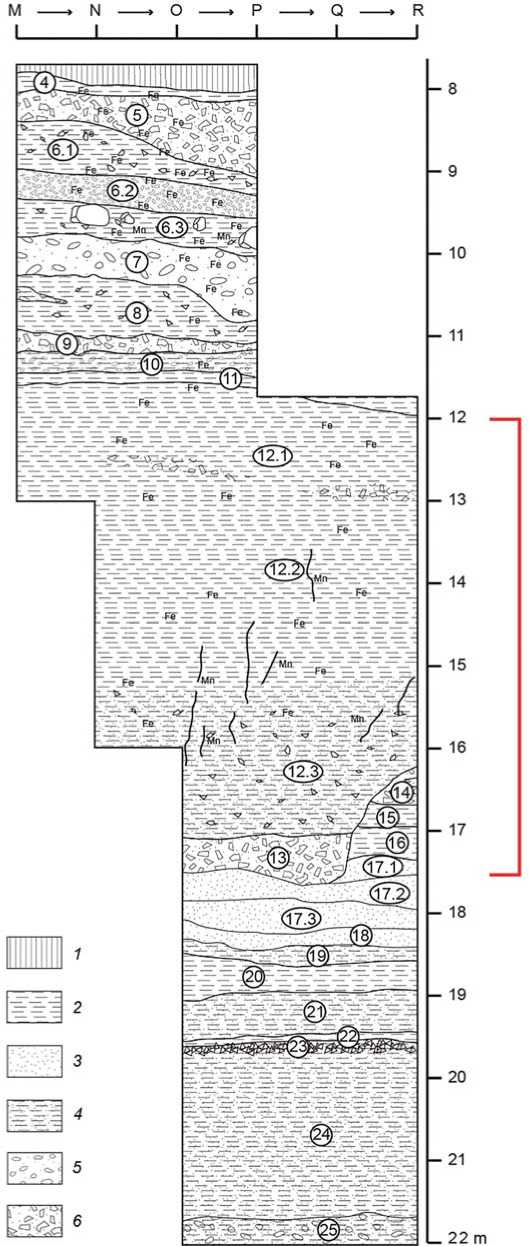
Fig. 1. Kulbulak stratigraphic column (after (Pavlenok K.K. et al., 2021)).
1 – technogenic sediments; 2 – loam; 3 – sandy sediments; 4 – sandy loam; 5 – pebble and boulder; 6 – blocks, rubble.
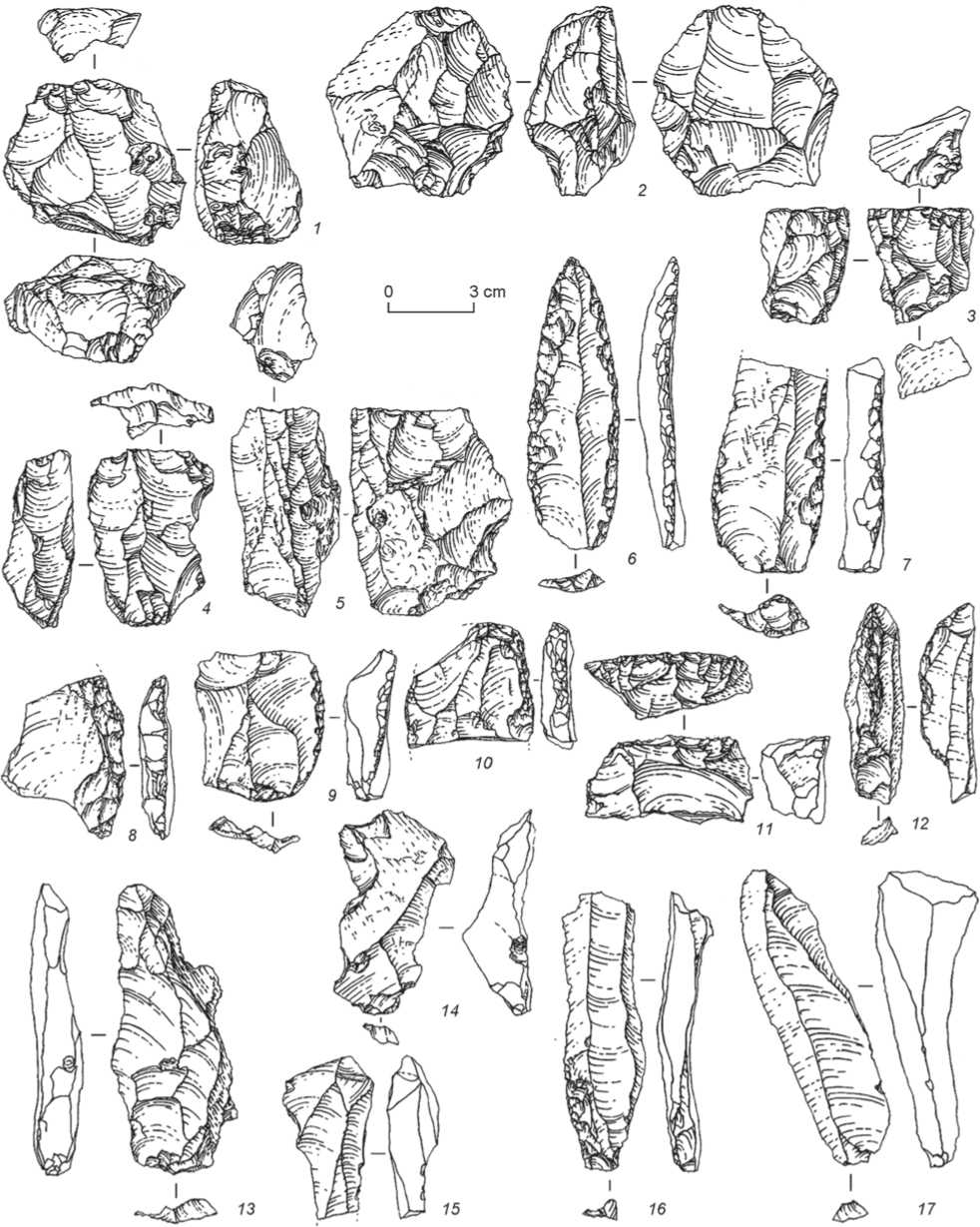
Fig. 2. Lithic artifacts from Kulbulak layer 24 (after (Pavlenok K.K., Pavlenok G.D., Kogai et al., 2019)).
1 , 2 – flat blade cores; 3 , 4 – small blade and bladelet cores; 5 – narrow-faced bladelet core; 6 – elongated point on blade; 7 – fragment of a blade with irregular marginal retouch; 8 – single longitudinal convex side-scraper; 9 – Levallois flake; 10 – double longitudinal-transverse side-scraper; 11 – transverse straight side-scraper; 12 , 15 , 16 – spalls for widening the flaking surface and smoothing its irregularities;
13 , 14 , 17 – spalls for shaping/rejuvenating the flaking surface.
The striking platforms are plain, dihedral, and coarsely faceted.
The abundance of coretrimming elements and chips indicates that the core shaping and reduction, as well as tool manufacturing, were executed by hominins at the site.
Layer 24 yielded a small number of tools ( n =7). Mostly blades and blade flakes were used as blanks, which was a characteristic feature of the lithic industry. The category of tools comprises an elongated point on a blade (Fig. 2, 6 ) and a proximal fragment of a large blade with finely retouched longitudinal edges (Fig. 2, 7 ). Side-scrapers are single longitudinal convex (Fig. 2, 8 ), transverse straight (Fig. 2, 11 ), and double longitudinal-transverse (Fig. 2, 10 ). Among the flakes, a Levallois flake with its edge shaped by fine marginal retouch (Fig. 2, 9 ) is noteworthy. The toolkit also includes an unidentifiable fragment of a retouched flake.
The finds from Kulbulak lowermost layer 24 suggest several important conclusions. The industry as a whole belongs to the Middle Paleolithic. Layer 24 is dated to the second half of MIS 7 (ca 200 ka BP). The Middle Paleolithic industry of this region is similar to that from the Khonako-3 site in Tajikistan in terms of age and technical and typological features. At both sites, the primary reduction technique was based on the Levallois and blade flaking
Fig. 3. Lithic artifacts from Kulbulak layer 23 (after (Krivoshapkin et al., 2010)).
1 , 2 , 7 , 8 – cores; 3 , 4 , 6 – end-scrapers; 5 – backed knife; 9 – side-scraper-like tool on blade.
aimed at the production of blanks. The researchers believed that the lithic collection from layer 24 illustrated one of the most ancient techniques of narrow-face flaking for obtaining blades and microblades.
The excavations of layer 23 at Kulbulak in 2010 yielded 4995 lithic artifacts. Among them, 4302 specimens (86.1 %) were identified as production waste (chips, chunks, shatters, and flakes up to 3 cm in size) (Krivoshapkin et al., 2010; Kolobova et al., 2016), 25 specimens (3.6 % excluding production waste)
were identified as cores, including 19 typologically identifiable pieces, which were subdivided into two types.
Flat cores ( n =12) were attributed to two subtypes. Subtype 1 includes single-platform, unifacial cores with a parallel flaking pattern for the production of flakes ( n =6); subtype 2 includes multi-platform, unifacial cores with a longitudinal-transverse flaking pattern for the production of flakes ( n =6). Heavily exhausted cores were recorded, which were modified into flat cores through the “truncating-faceting technique” (Fig. 3, 7 ).
Volumetric cores ( n =7) were also subdivided into two subtypes. Subtype 1 includes narrowfaced cores for the production of blades, bladelets, and microblades ( n =6). These cores show the following varieties: single-platform unifacial, with elongated-triangular (wedge-shaped) flaking surface ( n =3) (Fig. 3, 1 , 2 ) and double-platform showing bidirectional knapping ( n =3). Subtype 2 is represented by a core exhibiting prismatic knapping for the production of bladelets and microblades ( n =1). This core is similar to carinated products in technical and typological characteristics (Fig. 3, 8 ).
In the layer 23 collection, primary reduction was aimed mainly at detaching elongated blanks— blades and blade flakes. Among the total of 668 blanks, there are 246 blades (36.8 %), 176 bladelets (26.3 %), including 32 microblades and small bladelets (Fig. 4, 1–4 , 6 , 7 , 9 , 10 ); and 210 flakes. There are 33 core-trimming elements: 10 spec. are marginal, 15 spec. marginal laminar, 4 spec. are flakes resulted from trimming of flat cores’ hinges, 2 spec. are semi-crested, one crested blade, and one flake from the striking platform of a core. The striking platforms are mostly plain; however,
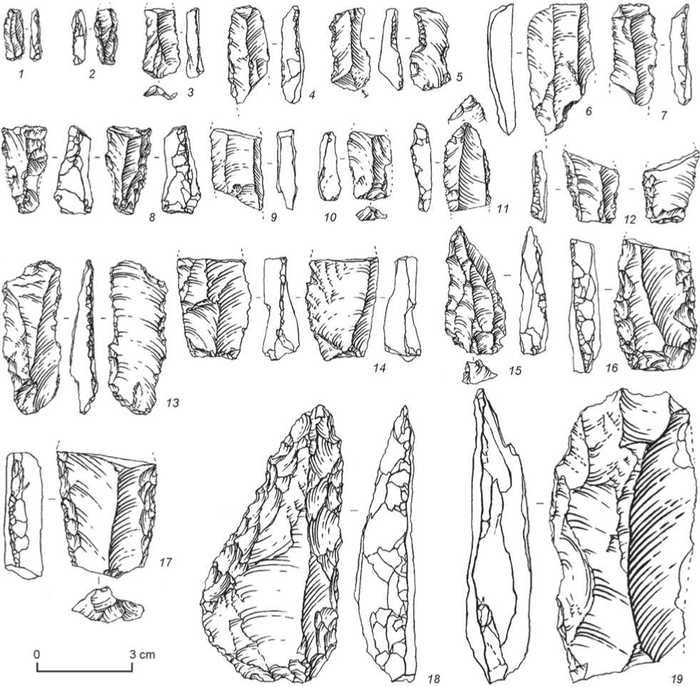
Fig. 4. Lithic artifacts from Kulbulak layer 23 (after (Krivoshapkin et al., 2010)).
1–4 , 6 , 7 , 9 , 10 – blades and bladelets; 5 , 8 , 11–14 , 19 – retouched blades and bladelets; 15 , 18 – retouched points; 16 , 17 – side-scrapers.
puctiform, dihedral, and faceted platforms have also been noted.
Layer 23 revealed 46 tools. These are dominated by end-scrapers ( n =14) of various shapes: with a convex working edge ( n =4) (see Fig. 3, 6 ), with a straight working edge ( n =3), with an oblique working edge ( n =2) (see Fig. 3, 4 ), and flake scrapers ( n =2). Several single tools were also found: a spurred side-scraper, a micro-end-scraper, a carinated end-scraper that is typologically close to carinated cores. There is a tool combining the features of an end-scraper and a sidescraper (see Fig. 3, 3 ).
The second largest group contains side-scrapers ( n =10): single longitudinal with straight working edge ( n =2) and double longitudinal with straight working edge ( n =5) (see Fig. 4, 16 , 17 ). Blades bearing heavy one- and two-stepped retouch ( n =2) (see Fig. 3, 9 ) are morphologically and functionally close to the side-scrapers. Other tool types are retouched points ( n =2) (see Fig. 4, 15 , 18 ), a tool with trimming signs, spurred tools ( n =2), a denticulate tool, a backed knife (see Fig. 3, 5 ), retouched flakes ( n =4), blades and bladelets (see Fig. 4, 1 – 4 , 6 , 7 , 9 , 10 ), and retouched blades and bladelets ( n =8) (see Fig. 4, 5 , 8 , 11–14 , 19 ).
The researchers argued that according to the main technical and typological indicators, the lithic industry of layer 23 illustrated the development of the traditions noted in the industry of the underlying layer. These two industries are undoubtedly connected also chronologically: judging by the stratigraphic profile, they are separated by a relatively small time gap. The artifacts from layer 23 demonstrate the volumetric core technique and the trend to produce large-sized blade blanks, while the industry of layer 24 shows a dominance of narrow-face flaking and carinated tools; though, a significant number of blades and microblades were identified in the layer 23 collection.
Layers 17–13 yielded a small amount of representative materials (Pavlenok K.K., Pavlenok G.D. et al., 2018). Despite the small number of diagnostic artifacts in the overlying layers, the available finds illustrate the continuity in the development between the industries of these and underlying layers 23 and 24, the main feature being the use of blade reduction and the use of blades and bladelets as blanks.
The most numerous and informative material comes from the culture-bearing layer 12 about 5 m thick, which is subdivided into three horizons/ sublayers (Derevianko, Pavlenok K.K., Shnaider et al., 2014; Kolobova, 2014; Derevianko, Pavlenok K.K., Pavlenok G.D. et al., 2016; Devyatova et al., 2016; and others).
Layer 12 was excavated over an area of 10 m2 in 2014–2016. The layer’s thickness varies from 4.65 m in the western part of the excavation to 4.0 m in the eastern part. Sublayer 12.3 yielded 2308 lithic artifacts. The share of the production waste ( n =1727) is 74.8 %, including chunks/chips/shatters ( n =1447) and unidentifiable spall fragments ( n =280). The category of core-like tools includes 14 spec. (1 %); core-like fragments, 7 spec.
The category of cores comprises blade and bladelet cores (Fig. 5, 4 ), blade and flake cores (Fig. 5, 7 ), and discoidal cores with traces of radial flaking (Fig. 5, 5 ). A convergent bladelet core shows a strongly convex striking platform with a broken edge. The share of exhausted cores is considerable.
The assemblage of spalls ( n =567, 24.5 %) includes: flakes – 440 spec. (large and medium – 139 spec., small – 301 spec., blades – 57 spec.; bladelets – 34 spec.; and core-trimming elements – 36 spec.
The tool-kit contains 50 spec. It includes a uniface, a uniface blank, 2 single longitudinal convex sidescrapers, a single longitudinal straight side-scraper (Fig. 5, 1 ), 3 double longitudinal side-scrapers with straight ( n =2) (Fig. 5, 6 ) and convex edges; a sidescraper, an end-scraper, a chisel-like tool, 2 truncated-faceted tools, 2 implements with signs of edgerounding, 14 retouched flakes (Fig. 5, 8 ), 8 retouched blades, and 12 fragments of tools of unclear typology.
The medium-sized uniface is sub-triangular in shape (Fig. 5, 10 ). Its ventral surface is completely covered with negative scars of various-sized removals made from various parts of the edge and oriented toward the artifact’s center. The end-scraper with a convex edge was fashioned on a small flake fragment (Fig. 5, 2 ). In the distal part of the spall, a convex scraper edge was prepared through abrupt marginal laminar retouch on the dorsal face.
The chisel-like tool (Fig. 5, 3 ) was made on the proximal fragment of a large spall. The facets of the fine abrupt, marginal, scaly retouch are located on both faces in the area of striking platform of the blank spall, overlapping the previous retouch scars. One truncated-faceted artifact shows the truncated element shaped in the area of the residual striking platform: truncation removals were made from the ventral surface; additional flattening removals, from the dorsal surface (Fig. 5, 9 ).
In layer 12, stone tools were recorded mainly in the upper part, particularly in sublayers 12.1 and 12.1. The lithics were scattered over the deposits of a total thickness of 1.5 m. Artifacts (over 1500 spec.) were recorded all over the layer. Nevertheless, in terms
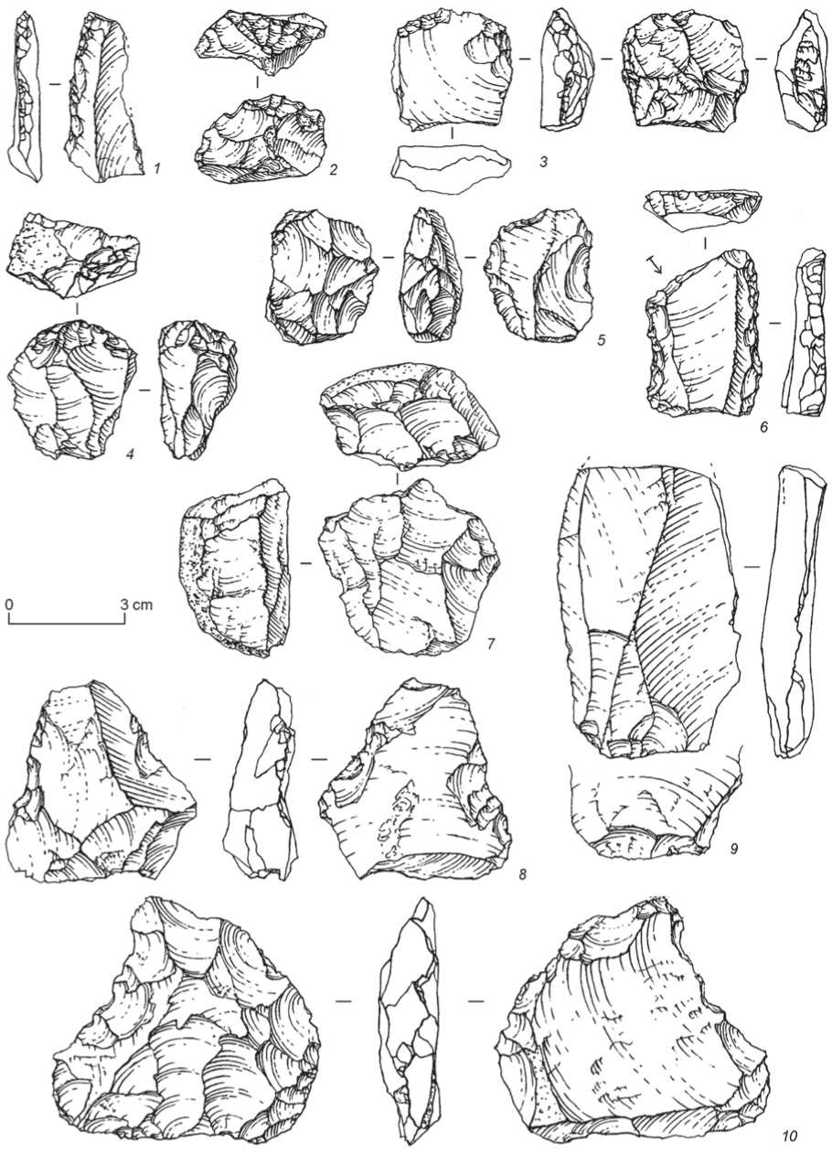
Fig. 5. Lithic artifacts from Kulbulak layer 12.3 (after (Derevianko, Pavlenok K.K., Pavlenok G.D. et al., 2016)).
1 , 6 – side-scrapers; 2 – end-scraper; 3 – chisel-like tool; 4 , 5 , 7 – cores; 8 – retouched flake; 9 – truncated-faceted artifact; 10 – uniface.
of technology and typology, the lithic industry is homogeneous.
Layers 11 and 10 have been attributed to the terminal stage of the Middle Paleolithic; these yielded a small number of artifacts, which, however, illustrated the sustainable trend of preferably blade reduction. Notably, the date of 82 ± 9 ka BP is available for layer 10 (Vandenberghe et al., 2014).
The analysis of the Kulbulak lithic industry, from layer 24 correlated to MIS 7 through to layer 10, has shown the gradual development of the Middle Paleolithic industry over more than 100 thousand years. This industry is characterized by the Levallois and blade flaking technique aimed at the production of blanks in the form of variously sized blades and microblades. The cores contain carinated varieties used for the detachment of microblades. Cores of this type from the Kulbulak site are probably among the oldest in Asia (Kolobova, Krivoshapkin, Flas et al., 2011; Kolobova, Kharevich, Bocharova et al., 2022). These cores can be considered the evidence of emergence of one of the earliest small-blade industries in Asia.
The final Middle and the transition to the Upper Paleolithic
The further development of the Middle Paleolithic blade industry in Uzbekistan is well illustrated by the archaeological materials from the site of Obi-Rakhmat discovered in 1962 by A.R. Mukhamedzhanov. The first excavations were conducted by M.M. Gerasimov and H.K. Nasretdinov, and in 1964–1965 by R.K. Suleimanov, who summarized the findings in a well-published and very informative monograph (Suleimanov, 1972).
The Obi-Rakhmat Grotto is located in the southwestern part of the Koksuy Ridge, at an altitude of 1250 m above sea level, in the valley of the Paltau River, a right tributary of the Chatkal (Grot Obi-Rakhmat, 2004). The grotto is a large rounded rockshelter facing south; its width in the entrance zone is 20 m, depth 9, maximum height of the vault is 11.8 m.
Suleimanov studied the Obi-Rakhmat industry using the statistical method of artifact analysis; he identified artifact complexes or tiers, each combining several culture-bearing layers. According to the main technical and typological features, he determined five industrial complexes: A – layers 21–15, B – 14–9, C – 8 and 7, D – 6–4, and E – layers 3–1.
The main type of blanks at Obi-Rakhmat Suleimanov described as prismatic blades. The blade index of the lithic collection was 60 % (Suleimanov, 1972). He analyzed the industries from the Obi-Rakhmat stratigraphic sequence and concluded that the Middle Paleolithic complex developed into the Upper Paleolithic within the framework of a single Obi-Rakhmat culture.
The statistical analysis allowed Suleimanov to substantiate the identification of the Obi-Rakhmat culture and to trace the successive evolutionary development of the Obi-Rakhmat industry with a gradual and constant emergence of Upper Paleolithic technical and typological features without any innovative abrupt changes or interruptions (Ibid.).
In 1998, the second stage of the Obi-Rakhmat Grotto studies began. It was carried out by the research team of the Institute of Archaeology and Ethnography SB RAS and the Institute of Archaeology of the Uzbekistan Academy of Sciences (scientific supervisors A.P. Derevianko and U.I. Islamov; the head of the team was first V.T. Petrin, and from 2001 to the present, the work has been led by A.I. Krivoshapkin). During the second stage of field work, the loose sediments inside the grotto were excavated almost completely, abundant archaeological materials were collected, a significant part of which was published. In the course of the excavations, the deposits of about 10 m thick were subdivided into 22 lithological layers, which contained 36 cultural horizons with varying degrees of saturation with archaeological materials: from several dozen in layer 16 to tens of thousands in layer 19 (Fig. 6).
In general, the grotto is filled with interbedded horizons of light-pale and gray sandy loam. The following pattern deserves attention: the pale layers are thicker – 50–60 cm; the gray layers are usually up to 15–25 cm thick, they are more saturated with artifacts, charcoal pieces, and bone remains. The detrital material contains mainly small, less often mediumsized, weakly rounded pieces of limestone. The Obi-Rakhmat stratigraphic column shows discrete culturebearing layers lying horizontally, slightly sloping to the southwest, toward the entrance zone and the western wall of the grotto, which excluded intermixture of archaeological materials. Cases of possible artifact shifts associated with the activities of humans and burrowing animals were recorded during the excavations.
The lithic industry from the Obi-Rakhmat Grotto was described in many publications (Grot Obi-Rakhmat, 2004; Derevianko, Islamov, Petrin et al., 1998, 1999; Derevianko, Krivoshapkin, Anoikin et al., 2001; Krivoshapkin, Anoikin, Rybin, 2001; Krivoshapkin, 2012; Krivoshapkin et al., 2003;
Mb
3 cm
3 cm
15.3
15.4
•600
19.2
21.3
3 cm
J9 5®^<
^-^(14.1
AMS
36,170 + 810 BP (AA-57114) cal 40,284-37,897 BP
AMS
41,400 ± 1600 BP (AA-31577) cal 46,411-40,463 BP
AMS
44,000 + 2000 BP (AA-31580)
cal 50,567-41,976 BP _______
AMS
42,100 ± 1700 В P (AA-31581) cal 47,872-40,652 BP
ESR (FT41) 32,000 ± 1100 BP(EU) 56,900 t 2400 BP (LU)
AMS
>46,000 BP(AA-35318)
ESR (FT25, 33, 34) 36,700 + 600 BP (EU) 65,500+ 1500 BP (LU)
AMS
48,800 ± 2400 BP (AA-36746) cal > 50,000-40,197 BP
ESR (FT26) 40,600 ± 1600 BP(EU) 72,800 + 3700 BP (LU)
ESR (FT27, 35, 36) 50,200 ± 1500 BP(EU) 87,100 t 3900 BP (LU)
-300
1 m
- -200
cm
-100
-400
-500
-700
-800
-900
Fig. 6. Geochronology, stratigraphy, and lithic artifacts from Obi-Rakhmat Grotto (after (Derevianko, 2009)).
Derevianko, 2009, 2011; Kolobova, Shalagina, 2013; Krivoshapkin, Pavlenok K.K., 2015; and others).
To show the continuity in the evolution of the technical-typological complex at this site, below I will describe the findings of excavations of some culture-bearing horizons (21, 19.5, and 16) from 2001 field season (Derevianko, Islamov, Krivoshapkin et al., 2002).
The lowermost cultural horizon 21.2 has yielded artifacts which allowed the complete reconstruction of a core through refitting (Slavinsky, Milyutin, 2004). Notably, all flakes from the core concentrated over an area not exceeding 1 m2. The refitted core can be described as having double platform, two striking surfaces and exhibiting traces of parallel flaking. At the final stage of utilization the microflaking was executed from its narrow face. This is the evidence for the employment of a narrow-face knapping technique for production of microblades during the earliest period of grotto occupation (Fig. 7, 7–11).
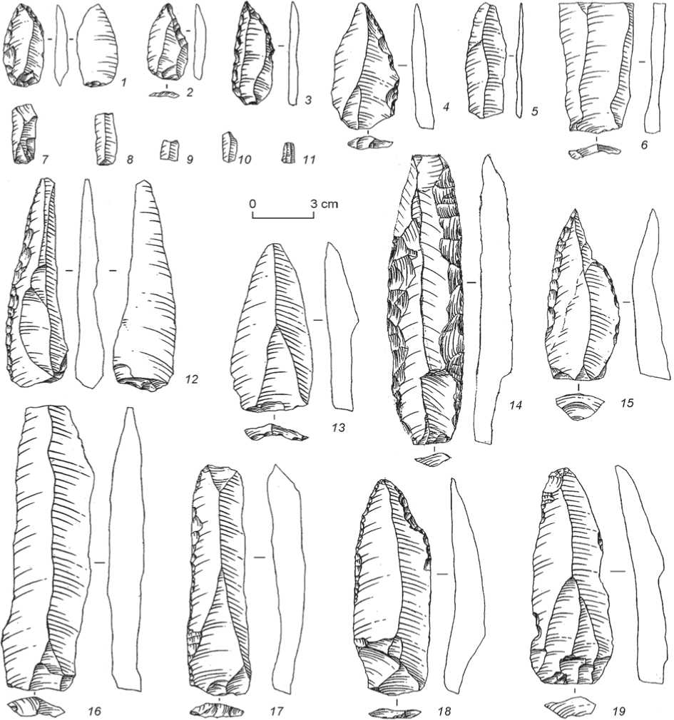
Fig. 7. Lithic artifacts from Obi-Rakhmat layer 21 (after (Derevianko, Krivoshapkin, Anoikin et al., 2004)).
1–3 , 15 – scraper-borers; 4 , 12 , 14 , 17 , 18 – side-scrapers; 5 , 19 – blades with irregular retouch; 6 , 13 , 16 – blades; 7–11 – microblades.
Tools were fashioned mainly on elongated blades and blade flakes. The tool category includes unifacial and bifacial side-scrapers treated mostly by fine and medium-sized one-stepped retouch (Fig. 7, 4 , 12 , 14 , 17 , 18 ); side-scrapers with well-prepared point at one end (scraper-borers?) (Fig. 7, 1–3 , 15 ). Many blades bear irregular retouch (Fig. 7, 5 , 19 ), and some blades show use-wear signs without retouching (Fig. 7, 6 , 13 , 16 ). Notably, the Obi-Rakhmat lithic artifacts, despite the small number of finds in the lowermost layer, provide information concerning the development of the technical and typological complex of the Kulbulak site. The main difference is that the number of elongated, regular-shaped blades is greater in the Obi-Rakhmat industry. This is explained by the fact that at Obi-Rakhmat, cores were prepared on fine-grained rock bars, which were suitable for the detachment of large-sized blades; at the same time, the tradition of manufacturing microblades still persisted.
The most abundant (more than 40,000 lithic artifacts) and informative collection has been recovered from layer 19, where 5 distinct cultural horizons have been identified. I will focus on the description of the industry from horizon 19.5. The total number of lithic artifacts is 14,692. Primary reduction is represented by: core-like implements ( n =48), flakes ( n =817), blades ( n =839), microblades ( n =47), blade flakes ( n =52), pointed blades ( n =27), triangular spalls ( n =46), points ( n =44), fragments ( n =98), chunks and chips ( n =12,674). The category of cores includes three Levallois specimens: one Levallois blade core (Fig. 8, 1 ) and two Levallois flake cores (Fig. 8, 4 ); six radial cores, seven flat cores exhibiting a parallel flaking pattern, including six blade cores (Fig. 8, 5 ) and one flake nucleus; three narrow-faced blade and microblade cores (Fig. 8, 3 ), and seven cores on spalls. There are also 21 irregular cores and core-like fragments.
The tool-kit comprises 162 specimens. It includes Levallois points (n=7), one retouched Levallois point, elongated Levallois points (n=3), retouched elongated Levallois points (n=2), Levallois flakes (n=4), Levallois blades (n=23), unretouched points and their fragments (n=12), elongated points (n=10), retouched points and their fragments (n=5) (Fig. 8, 7, 10), retouched micropoints (n=2), side-scrapers (n=19) (Fig. 8, 15), a denticulate-notched tool, denticulate tools (n=2), a notched tool (Fig. 8, 16), spurred tools (n=2), end-scrapers (n=3) (Fig. 8, 12), borers (n=2) (Fig. 8, 8, 17), backed knives (n=2) (Fig. 8, 6), a blade with signs of trimming (Fig. 8, 11), blades with irregular retouch (n=10) (Fig. 8, 14), truncated spalls (n=4), combination tools—raclettes with points (n=3) (Fig. 8, 9, 13), retouched flakes (n=12), a tool fragment, retouched fragments (n=2) and chunks with retouch (n=3).
The technical and typological analysis of the lithic artifacts from layer 19 has revealed certain characteristic features of the Obi-Rakhmat industry. It was established that the leading primary reduction strategies were those aimed at the production of blades and blade blanks (including microblades) from narrow-faced and volumetric single-platform (more rarely, double-platform) cores of the Upper Paleolithic type. The tool-kit is dominated by retouched blades, burins, elongated points (including pointed blades), borers, end-scrapers, and backed knives. The category of points on blades includes a series of small, carefully prepared artifacts, usually with basal thinning, which most likely served as tips for projectiles. Such points are also typical of the overlying culture-bearing horizons, which makes it possible to consider them as the Obi-Rakhmat markers (Derevianko, Krivoshapkin, Anoikin et al., 2004). At the early stage of development of the Obi-Rakhmat culture, a rather large number of blade cores, including narrow-faced ones, and Upper Paleolithic tools have been identified.
The Obi-Rakhmat Grotto, starting from layer 14 (dated to 48,800 ± 2400 BP (AA-36746)) contains Upper Paleolithic artifacts. This does not mean that in future, when sufficiently representative material is found in layer 15, the lower boundary of the Upper Paleolithic industry will not be considered older. Thus, the Obi-Rakhmat Grotto is one of the unique Paleolithic sites in Eurasia, where 20 cultural layers and 36 horizons of human habitation were recorded within the clear boundaries of lithological layer 22.
The Obi-Rakhmat lithic industry, despite the large chronological range (90–30 ka BP) and the technical and typological homogeneity, clearly demonstrates its evolutionary character (without interruptions and innovative changes), which is illustrated by the increasing frequency of prismatic reduction in stone knapping, an increasing blade index and number of microblades up the profile (layers 21–15), by the decrease in the number of Levallois cores and, accordingly, the sizes of blanks, as well as by the continuity between the tools of the Middle and Upper Paleolithic types.
The archaeological materials from Obi-Rakhmat, same as those from Denisova Cave, provide a clear evidence of the Middle to the Upper Paleolithic transition, which lasted for a long time. Starting from lithological layer 17, the culture-bearing horizons demonstrate domination of the Upper Paleolithic
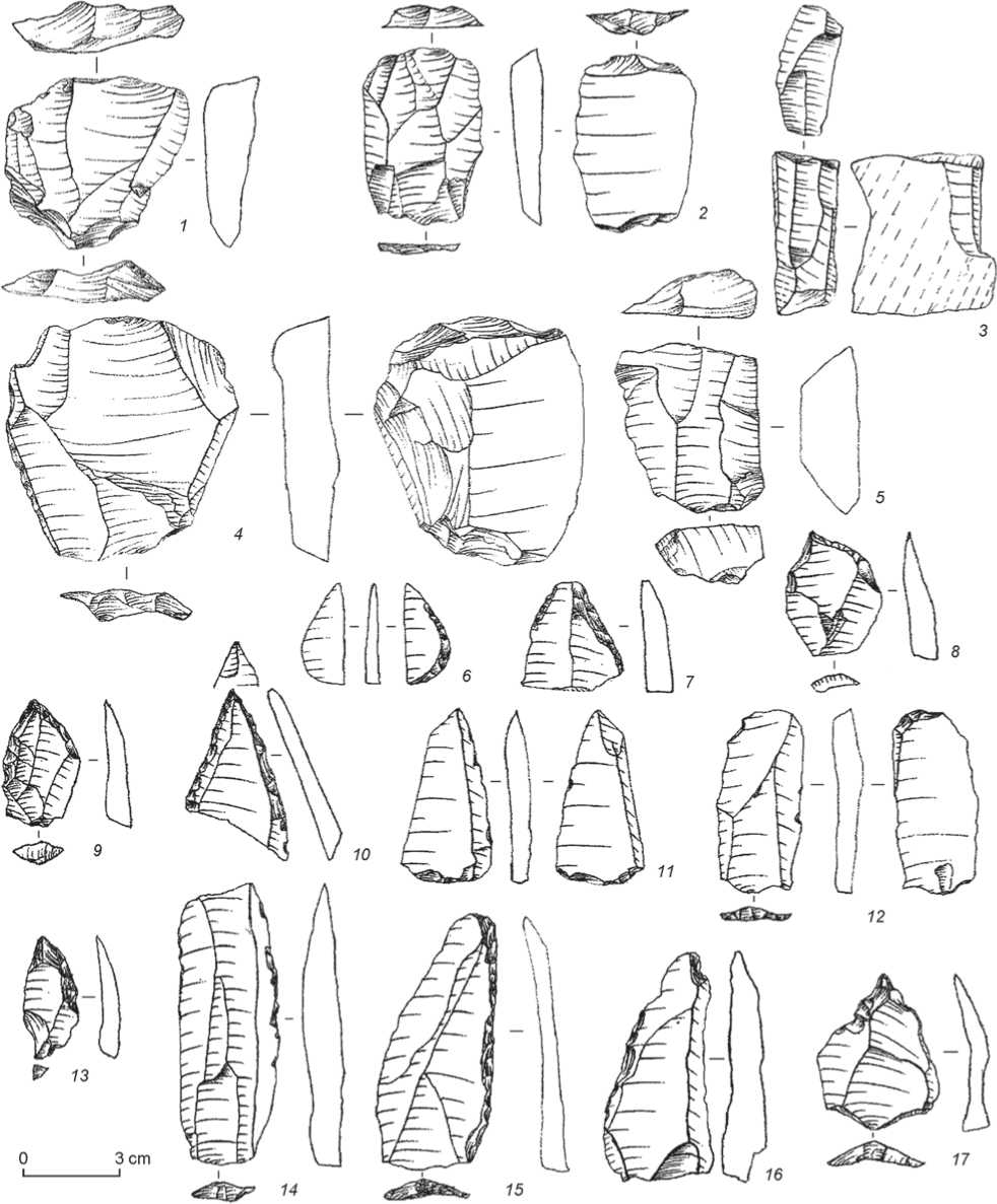
Fig. 8. Lithic artifacts from Obi-Rakhmat horizon 19.5 (after (Derevianko, Krivoshapkin, Anoikin et al., 2004)).
1 , 4 – Levallois cores; 2 – frontal spall from a core showing bidirectional knapping; 3 – narrow-faced core for production of bladelets and microblades; 5 – flat core; 6 – backed knife; 7 , 10 – point fragments; 8 , 17 – borers; 9 , 13 – raclettes with retouched points; 11 – blade with trimming signs; 12 – end-scraper; 14 – irregularly retouched blade; 15 – side-scraper; 16 – notched tool.
industry over the Middle Paleolithic one. Available AMS radiocarbon dates make it possible to trace the decrease in the amount of the Middle Paleolithic artifacts and the relevant increase of the Upper Paleolithic artifacts up the profile. Dates for layer 7 are 36,170 ± 810 (AA-57114), calibrated* date 40,287– 37,897 BP, and 44,000 ± 1600 (AA-31577); for horizon 8.3 – 44,000 ± 2000 (AA-31580), cal 50,567– 41,976 BP; for layer 9 – 42,100 ± 1700 (AA-31581), cal 47,872–40,652 BP; for horizon 13.2 – >46,000 (AA-35318); for horizon 14.3 – 48,800 ± 2400 (AA-36746), cal >50,000 BP (see Fig. 6). The stratigraphic sequence of the Obi-Rakhmat Grotto has also been dated by the ESR method. The derived dates point to the initial Upper Paleolithic prior to 50 ka BP; the transitional stage has been dated to the range of 60–55 ka BP, like in Denisova Cave (Derevianko, 2022). The Obi-Rakhmat collection shows not only one of the earliest Upper Paleolithic industry in Eurasia, but also provides convincing evidence of its convergent development.
For a long time, the origins of the Obi-Rakhmat industry were unclear. The resumed excavations (since 2007) in Kulbulak, in the lowermost layers 24 and 23, have produced the Middle Paleolithic industry with components of the Levallois, blade and microblade reduction, dating back to the period corresponding to MIS 7; the origins of this lithic industry can be correlated with the Denisovan industry uncovered in pedocomplex 2 at Khonako-3 (Derevianko, 2024b). The archaeological materials of the cultural layers overlying layer 23 demonstrate further development and continuity in the evolution of the Middle Paleolithic industry at the site.
The artifacts from Kulbulak cultural layers 11 and 10 have been attributed to the terminal stage of the Middle Paleolithic blade industry. The date obtained for layer 10 is 82 ± 9 ka BP (Vandenberghe et al., 2014). The currently available material from Kulbulak does not make it possible to trace the transition from Middle to Upper Paleolithic, which is clearly identified in layer 2 with a date of 39,000 ± 4000 BP (GLL-080316) (Kolobova, 2014). Layers 3–9 produced a significantly small number of stone tools, which do not illustrate the development of the Middle Paleolithic industry at the site.
The terminal stage of the Kulbulak Middle Paleolithic industry is well represented by the Obi-Rakhmat lithic industry. The final Middle Paleolithic at Kulbulak layer 10 is dated to about 80 ka BP; hence, hominins with the Kulbulak terminal Middle Paleolithic industry occupied Obi-Rakhmat around 90–80 ka BP. Considering that Kulbulak was inhabited by Denisovans, they were the first settlers of the Obi-Rakhmat Grotto.
The results of excavations of layer 16, which yielded a small number of lithic artifacts and anthropological fossils (Derevianko, Krivoshapkin, Anoikin et al., 2001; Derevianko, Krivoshapkin, Slavinsky et al., 2003) are of great importance for understanding the development of the Obi-Rakhmat lithic industry and the taxonomic affiliation of the grotto inhabitants.
Layer 16 was rather thick (0.8 m); however, it yielded only 180 artifacts, vividly representing the blade-based lithic industry.
The core-like items ( n =2) are represented by a bifacial double-platform core and a medium-sized core-like fragment. Plain, prepared by a single blow, opposing striking platforms of the core are strongly beveled. Adjacent frontal (narrow-end and flat) flaking surfaces were knapped in opposite directions and bear negative scars of small laminar removals (Fig. 9, 14 ).
A total of 36 flakes were recovered. The blades ( n =16) were subdivided by metric indicators into large (over 10 cm long) – 5 spec., medium-sized (7–10 cm) – 6 spec., and small (5–7 cm) – 5 spec. The residual striking platforms are usually plain (62 %); the remaining types of platforms included linear, punctiform, dihedral, and indeterminate varieties. Along with complete blades, ten blade fragments were found. Six pointed blanks (apart from blade blanks) were recorded in layer 16 (Fig. 9, 4 ).
The finds comprise seven tools, including two Levallois points (Fig. 9, 3 , 7 ). The double straight-convex side-scrapers were fashioned on blades. The straight working edge was prepared on the left longitudinal margin by dorsal continuous, abrupt, stepped, invasive, mid-faceted retouch spreading over the entire margin. The convex edge was prepared by dorsal continuous, vertical, scaly retouch at the medial part of the right longitudinal margin (Fig. 9, 1 , 9 ).
Denticulate tools – 2 spec. One tool was prepared on a large blade (Fig. 9, 13 ). Its left longitudinal margin was fashioned by large-scale, dorsal, abrupt, discontinuous, strongly modifying scaly flake scars localized in the medial-distal zone and forming a serrated working edge. The dorsal surface bears negative scars of several large removals in the medial and distal zones at the opposite edge. The other tool was made on a distal fragment of a flake; its right longitudinal margin was fashioned by dorsal abrupt,
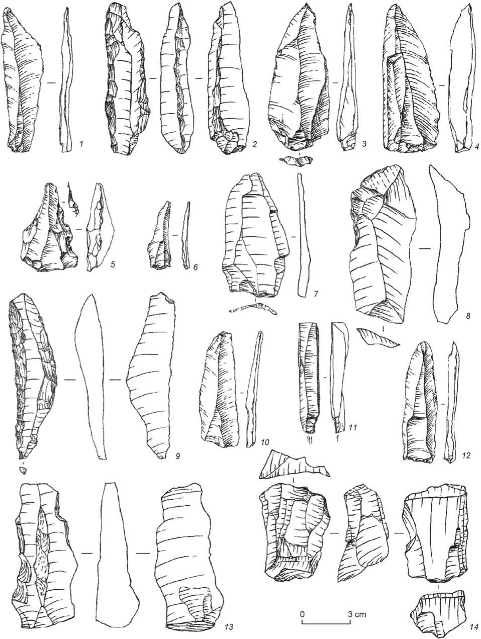
Fig. 9. Lithic artifacts from Obi-Rakhmat layer 16 (after (Derevianko, Krivoshapkin, Slavinsky et al., 2003)).
1 , 9 – side-scrapers; 2 – combination tool; 3 , 7 – Levallois points; 4 – point; 5 , 13 – denticulate tools; 6 , 8 , 10 , 12 – blades with use-wear signs; 11 – burin; 14 – core.
discontinuous, scaly retouch forming a serrated working edge (Fig. 9, 5 ).
The angular multifaceted burin (found in close proximity to anthropological remains) was prepared on a marginal spall (Fig. 9, 11 ). Flaking was carried out from the plain residual striking platform of the spall onto the right-side longitudinal margin and the ventral face of the tool.
The combination tool shows the working edges of a straight double side-scraper and an end-scraper (Fig. 9, 2 ). Several blades with use-wear signs have also been recovered from layer 16 (Fig. 9, 6 , 8 , 10 , 12 ).
The artifacts from cultural layer 16 at Obi-Rakhmat, despite their small number, show the Upper Paleolithic trend in the development of the industry, as well as the vivid ties in the technical and typological features with the artifacts from both the underlying and overlying strata. Taking into account the age of layer 14 (see Fig. 6), layer 16 can be dated to approximately 60 ka BP, and the industry can be attributed to the Middle to Upper Paleolithic transition.
Paleoanthropological finds from Obi-Rakhmat layer 16 (OR-1) include six isolated well-preserved permanent teeth and about 150 small fragments of cranial bones. Initially, T.A. Chikisheva examined the recovered dental remains and pointed to the extremely archaic large sizes and shapes of the crowns (OR-1) on the one hand, and to certain morphological similarity with the teeth of modern humans on the other hand.
Later, the fossils from the Obi-Rakhmat Grotto (OR-1) were examined by other researchers (Glantz, Viola, Chikisheva, 2004; Viola, Seidler, Nadden, 2004; Glantz et al., 2008; Bailey et al., 2008). They determined the fossils as belonging to a single individual aged 9–12 years. As to the taxonomic affiliation of OR-1, anthropologists identified two diagnostic features of the fossils. The OR-1 dental system demonstrated large teeth and archaic traits that brought it closer to the East Asian H. erectus. Examination of skull fragments has shown that, unlike the teeth, their morphological structure was more consistent with modern humans. The parietal part is quite large; its dimensions exceed the range of variations in Neanderthals of a similar and older age. The skull fragments are quite thin. In OR-1, the parietal opening is located on the right side of the parietal bone. This position is noted in 37–80 % of modern humans. In fossil hominins, it is much less common. Anthropologists point out the mosaic morphology of the ear labyrinth, which is similar to that of Neanderthals. Despite the complexity of the taxonomic definition of OR-1, some researchers are inclined to correlate the individual with Neanderthals. This conclusion was made before the discovery of a new taxon of Denisovans. I have considered the issue of the taxonomic affiliation of OR-1 in a number of works (Derevianko, 2022, 2024a, b, etc.). I have put forward a well-supported hypothesis that this individual could not have been a Neanderthal, but was a representative of the Denisovan taxon.
Why OR-1 cannot be classified as Neanderthal. The hominins from Obi-Rakhmat and Teshik-Tash dispersed over the territory of Uzbekistan at the same time—about 50–60 ka BP. The dental system of OR-1 is completely different from that of European and Palestinian Neanderthals. The OR-1 individual belonged to the Denisovan taxon. The evolving Denisovans partially assimilated with the Central Asian H. erectus population, and inherited large teeth with a number of archaic traits from that taxon. The morphological similarity of the ear labyrinth of OR-1 and Neanderthals can be explained by the fact that Denisovans and Neanderthals had evolved from the same ancestral species— H. heidelbergensis . Around 400 ka BP, when this lineage was split, Denisovans settled in Central Asia, and Neanderthals in Europe; in the process of morphological and genetic evolution, these taxa acquired new derivative features and retained the archaic ones (Derevianko, 2024a). Moreover, the morphology of bony ear labyrinth of the Neanderthal type can also be traced in some Upper Paleolithic people of the anatomically modern type (Razhev et al., 2024).
Thus, the main anthropological characteristics of OR-1 do not provide grounds to attribute this individual to Neanderthal taxon. The lithic industries of the Obi-Rakhmat Grotto and Teshik-Tash Cave are completely different from each other. The Obi-Rakhmat Grotto demonstrates a local version of the Denisovan Middle Paleolithic industry, while Teshik-Tash Cave contains a Mousterian industry. Consequently, there is every reason to believe that the Obi-Rakhmat Grotto was inhabited by H. s. denisovan . Moreover, the Obi-Rakhmat and Teshik-Tash tribes populated the territory of Uzbekistan at the same time, which hampers the differentiate on of lithic industries from other sites dated to the first half of the Upper Pleistocene.
In the 20th century, a significant number of stratified sites and localities with surface occurrence of cultural remains were found and attributed to the terminal stage of the Uzbekistan Middle Paleolithic, including Kuturbulak, Zirabulak, Katasai, Khodjikent-1 and -2, Gurdara, Amankutan, and others. At that period, the hominin lithic industry in this area exhibited the greatest variability of technical and typological complexes, which was the result of dispersal of two taxa—Denisovans and Neanderthals.
The sites of Kuturbulak and Zirabulak were discovered in the middle reaches of the Zarafshan River in 1971. They were located 1 km from each other, at the foot of the low Zirabulak mountain range, near the Kuturbulak and Zirabulak springs, which gave them their names (Tashkenbaev, Suleimanov, 1980). At Kuturbulak, excavation trench was established over an area of 165 m2; five lithological layers were identified (excluding the uppermost heavily disturbed sod horizon). The Kuturbulak and Zirabulak stratigraphic sequences were strongly affected by the springs’ activity, which resulted in the mixing of archaeological materials (Ranov, Nesmeyanov, 1973). In 1995, a joint Uzbek-Polish expedition led by K. Szymczak and T.Y. Grechkina worked at Kuturbulak. The researchers came to the conclusion that the Middle Paleolithic materials were redeposited (Szymczak, 2000).
The inhabitants of both sites used local raw materials from riverbed or coastal alluvium. At Kuturbulak, about 75 % of the artifacts were made of dark, fairly dense, fine-grained quartz sandstone of various colors—from almost black to ash-gray. This raw material is ductile and can be easily flaked. Other available raw materials were quartzite and, more rarely, flint. Let us briefly dwell on the characteristics of the lithic collection of this site. A more complete description was provided by N.K. Tashkenbaev and R.K. Suleimanov (1980), as well as B.K. Saifullaev (2001).
Analysis of the industry from Kuturbulak cultural layers has shown that the typology of the tools is generally similar to that of the Obi-Rakhmat. A distinctive feature of the Kuturbulak assemblages is a large number (70 %) of artifacts with signs of secondary working, and pebble tools (Tashkenbaev, Suleimanov, 1980: 57). In my opinion, in the Kuturbulak complex, the proportion of radial flaking is significantly higher and that of blade reduction is lower as compared to the Obi-Rakhmat industry. In the Kuturbulak collection, micro-flaking was found to be almost absent. The greater proportion of blades at Obi-Rakhmat can possibly be explained by the use of blanks in the form of bars; furthermore, the influence of regional specifics on these industrial complexes and their non-contemporaneity cannot be excluded. The lithic artifacts from Zirabulak are typologically quite similar to those from Kuturbulak. Excavators dug three test pits of 4 m2 each at Zirabulak in 1972. A small number of stone tools similar to Kuturbulak artifacts were uncovered there.
No absolute dates were obtained for the both sites. The only datable find is the mandible of a Trogontherium elephant from Kuturbulak, which was recovered from the boundary between layers 2 and 3, and obviously wasn’t located in situ . The age estimation based on this find should be considered preliminary.
Three sites of the final Middle Paleolithic have been discovered in the Zarafshan Valley, in the caves of Amankutan, Takaliksay, and Gurdara. The excavations produced a small number of Pleistocene animal bones and stone tools (Tashkenbaev, Suleimanov, 1980). The best-studied cave-site is Amankutan (1947–1957). The site yielded 220 artifacts made of flint, siliceous limestone, diorite, and quartz rocks. Primary reduction is represented by four discoidal cores. Eight blades, including one Levallois blade with a faceted striking platform, were found. Researchers identified 2 pointed tools, 2 side-scraper-like tools, and 12 denticulate-notched tools. Several Upper Paleolithic tools were found: six end-scrapers, two borers, and one atypical burin. No absolute dates were generated for the Amankutan site. V.A. Ranov and S.A. Nesmeyanov attributed it to the terminal Middle Pleistocene and the Mousterian culture (Ranov, 1971; Ranov, Nesmeyanov, 1973).
The lithic industry of the above-mentioned sites can be considered a regional variant of the final stage of the Denisovan Middle Paleolithic industry. A somewhat different technical and typological complex of stone tools was revealed at Khodjikent-1 and -2. The Khodjikent-1 Grotto was studied by A.P. Okladnikov in 1958–1959 (1958, 1961, 1963). During the excavations, a comparatively small number of lithic artifacts ( n =374) was uncovered. Okladnikov attributed the grotto lithics to the late variant of the Levallois-Mousterian culture, and did not exclude the possibility of its “development” into the Upper Paleolithic. Ranov included the Khodjikent-1 industry in the same group as the Obi-Rakhmat (1971, 1972). The lithic collection similar to that of Khodjikent-1 was recovered from the nearby Khodjikent-2 Grotto. This explains the difficulty of attribution of the industries either to the Denisovan or Neanderthal taxa, since these were found at the sites without geochronological data and with approximate age estimation in the range of 90–50 ka BP.
Several open-air sites have been explored in recent years by the joint Russian-Uzbek archaeological expedition. In 2018–2023, in the valley of the Ertashsay River, a tributary of the Akhangaran River, twelve sites were discovered with surface occurrence of cultural layer and a small number of lithic artifacts (Ertashsay-1–12), attributed to a wide chronological and techno-typological range (Middle Paleolithic to final Upper Paleolithic) (Pavlenok K.K., Kot, Pavlenok G.D. et al., 2019; Pavlenok G.D. et al., 2020; Pavlenok K.K. et al., 2021). Particularly noteworthy among them is the site of Kuksaray-2, located on the ridge between the Kuksaray and Dziblon gullies, on the right bank of the Akhangaran River.
Excavations at Kuksaray-2 were carried out in 2021–2023. Four test pits and two excavation trenches were established, showing certain variability in the stratigraphic sequence and the number of cultural layers. In total, about 400 lithic artifacts were recovered. An OSL-date of 68 ± 4.2 ka BP was obtained for layer 7 (Pavlenok K.K. et al., 2021, 2022a, b, 2023; Pavlenok et al., 2022).
The preliminary analysis of lithics from excavations 1 and 2 has led the researchers to the conclusion that the Kuksaray-2 lithic industry contains two separate cultural complexes—an older one, similar to the Sel-Ungur industry, which was not previously recorded in the Akhangaran River valley, and a younger blade-based one, which can be considered autochthonous. The researchers has put forward an assumption about the alternate habitation of the site by the carriers of two different stone-working traditions instead of the “evolutionary” model, which assumed a constant enrichment of the “Sel-Ungur” complexes with a blade component (Pavlenok K.K. et al., 2022a, b).
The conclusion as to the specifics of the Kuksaray-2 industry should be considered preliminary, because it was based on 400 lithic artifacts found in two excavations and several test pits, among which flakes, spalls, shatters, and chips, predominate, while stone implements of diagnostic types are few. Validity of the identification of the so-called markers (Tayacian point, Sel-Ungur-type side-scraper, Sel-Ungur retouch) raises serious doubts. It should be borne in mind that in the first half of the Upper Pleistocene, only Denisovans and Neanderthals could have settled in the territory of Uzbekistan and adjacent areas.
The Obi-Rakhmat industry shows continuous evolution based on blade reduction for at least 50 thousand years. This industry belonged to the Denisovans. The Teshik-Tash Grotto produced a Mousterian industry that differs from the Kuksaray-2 techno-typological complex. The lithic industry from Cave Sel-Ungur in Kyrgyzstan referred to one of the local trends of the Denisovan Middle Paleolithic industry (Derevianko, 2024b).
Conclusions
No Early Paleolithic sites with pebble-flake industry have yet been discovered in Uzbekistan, although the initial peopling of Central Asia by H. erectus tribes occurred 900–800 ka BP. The Kuldara site in Tajikistan belongs to this period (Ranov et al., 1987). The Karatau culture, identified by V.A. Ranov (1977), dates back to a later period, 600–350 ka BP. At the terminal stage of the Karatau culture, pedocomplex 4 at the sites of Khonako-3, Obi-Mazar-4, and Lakhuti-4 clearly demonstrates Middle Paleolithic elements in the Lower Paleolithic industry of hominins, which is explained by the migration of the morphologically and genetically developing Denisovan taxon to this territory after its split from the Neanderthals in the Levant ca 400 ka BP. Around 200 ka BP, or even earlier, the morphologically and genetically evolving Denisovan taxon left Tajikistan and started to disperse over the territory of Uzbekistan. Kulbulak is the earliest and most important site here, yielding abundant lithic collection. The collection suggests that around 200 ka BP or perhaps somewhat earlier, this territory was populated by H. s. denisovan with a Middle Paleolithic industry based on the use of mainly Levallois and blade techniques in primary reduction aimed at the production of blades and convergent blanks.
Noteworthy is the emergence in the industry of the narrow-faced and carinated cores for the detachment of blanks in the form of small blades and microblades. This is one of the earliest examples of microblade reduction in Eurasia. A peculiarity of the Kulbulak site is a gradual increase, up the stratigraphic profile, in the number of Upper Paleolithic tools made on blade blanks.
The Obi-Rakhmat technocomplex has shown the further development of the Kulbulak Middle Paleolithic industry. The Denisovans first inhabited the grotto ca 90–80 ka BP, and the entire stratigraphic sequence (21 cultural layers and 36 habitation horizons) of the site clearly demonstrates the development of the terminal Middle Paleolithic industry and the evolution on this basis of the Middle to initial Upper Paleolithic transition industry. The transitional period in Uzbekistan should be dated to no later than 50 ka BP or perhaps even earlier (Krivoshapkin, 2012).
The Kulbulak and Obi-Rakhmat lithic industry shows a continuous development over a period of about 150 thousand years. According to the main primary reduction features, technical and typological characteristics of the tool-kit, and the methods of its manufacture, this industry reveals parallels with the Middle Paleolithic industry of the Levant in the west and especially with the Denisovan industry of Denisova Cave in the east. The similarity of the Middle Paleolithic industries of Kulbulak and Levant is explained by the fact that Denisovans, after leaving the Levant about 400–350 ka BP, despite all the changes in their industry associated with migration through the Iranian Plateau, dispersal over Central Asia, and adaptation to changing environmental conditions, retained some basic elements of the Levantine Middle Paleolithic.
The parallels in the Middle Paleolithic of Uzbekistan and Altai are the result of dispersal of Denisovans over these territories prior to the arrival of Neanderthals. The Denisovans populating the vast territories of Central Asia, part of East Asia, and Southern Siberia with different environmental settings, landscapes, flora and fauna, and availability of water and lithic resources, had to develop various adaptation strategies, which led to the emergence of regional variants of lithic industrial complexes. More than ten local variants have been identified in the Neanderthal culture in Europe alone. In the course of further studies in the regions where Denisovans could have settled (and they really did in the vast territories of Central, East, and Southeast Asia according to the available genetic data (Meyer et al., 2012; Prüfer et al., 2014)), researchers will identify local variants of the Denisovan lithic industry there, which originated as a result of living in various environmental conditions.
