The Russian pioneers' winter camp on Karachinsky island, the Lower Tobol river, Western Siberia

Author: Matveeva N.P., Yakimov A.S., Larina N.S., Agafonov L.I.
Journal: Archaeology, Ethnology & Anthropology of Eurasia @journal-aeae-en
Section: The metal ages and medieval period
Article in issue: 1 т.46, 2018.
Free access
In 2014, an expeditionfrom Tyumen State University excavated an underground dwelling on Karachinslqt Island, in the floodplain of the Tbbol, to check the chronicle data saying that Yermqk qnd his Cossacks had spent q winter at that place during their Siberian campaign. The log structure, measuring I0 m by 5 m by 2 m, consisted of two rooms. Three or four bottom tiers of logs have been preserved. Remains of a cellar were found in the central part east of the oven. The building existed for a short time because the area around it was sterile. Lenses of calcination and charcoal, and traces of fire on the logs of the structure suggest that it had burnt down. Then it was repaired, but the amount of garbage and kitchen waste is small. All household effects were carried out before the dwellers left. Finds include pottery, a grindstone, a potter s scraper, and pieces of slag and metal. An AMS date of the wood, generated at Arizona University, falls within the 17th century. The chemical analysis of background and old soils indicates intense use of the islandfor pqsture and manufacture. In sum, our survey provides no evidence of Yermak's stay on the island during his campaign. According to R.G. Skrynnikov, the Cossacks marchedfrom the Stroganov forts to the Siberian Khanate capital without wintering, which was tactically correct, since the Thtar forces were weak and fragmented because of Mametkul's foray into the Ural towns.
Russian colonization, siberia, winter camp, tobol, log dugout, soil analysis, metalworking, buried soil, chemical elements
Short address: https://sciup.org/145146029
IDR: 145146029
Text of the scientific article The Russian pioneers' winter camp on Karachinsky island, the Lower Tobol river, Western Siberia
Sources contain very scarce information about the great epoch of the Russian conquest of Siberia, and in particular about the campaign of the Cossacks from the Stroganov lands to Qashliq. It has been proved that the “Siberian Chronicles” express the interests of certain groups, and a number of events there are clearly fictitious (Dergacheva-Skop, 1965: 17; Romodanovskaya, 2002: 242). Thus, quantitative data from the sources about the expedition greatly vary. For example, we do not know for certain the duration (from three to six years), numbers (300 to 7000 persons), or the route the detachment took, which is described inconsistently with the indication of various rivers and passes (Skrynnikov, 1986: 151–153, 249–250). Since
We considered it appropriate to start the analysis of factual evidence behind the Siberian campaign by verifying the most well-founded theory of R.G. Skrynnikov (1986: 215, 241–246), according to which it took two months to take Qashliq after the departure from the Chusovsky town. Thus, we decided to examine Karachinsky Island (Fig. 1) as the most promising place for finding archaeological evidence of a battle or encampment (Matveeva, Anoshko, 2014). According to the Remezov Chronicle, the town of Murza Karacha was conquered two months before the attack on the abatis on the Chuvash Cape (Sibirskiye letopisi…, 2008: 417, 420). During the battle, “riches”, cattle, and a prince were captured there (Ibid.: 197). According to one theory (Sergeev, 1959), Yermak’s detachment spent nearly a year in the town of Karacha. According to another theory (of R.S. Skrynnikov and S.G. Parkhimovich), the Cossacks spent all winters of the Siberian campaign there because of the small area of the fortress in Isker. R.G. Skrynnikov argued that the Cossacks spent one winter in the Karachin site after the Pelym campaign in 1583 (1986: 241, 244). Parkhimovich suggested that the detachment of Yermak at the beginning of the campaign and the detachment of Semyon Bolkhovsky at the end of the campaign spent a winter there (1984). Some sources do not mention spending a winter in this place. For instance, the Rumyantsev Chronicler reports, “…and they conquered the Ulus of Karacha, and acquired a lot of riches, and brought them to their boats” (Polnoye sobraniye…, 1987: 33). According to the Stroganov Chronicle, “… they battled with Karacha, the Khan’s adviser, and conquered his Ulus, and took the Khan’s honey and Khan’s wealth to their boats”; the Pogodin Chronicler gives the same information (Sibirskiye letopisi…, 2008: 20–21, 277).
In order to establish the facts of the battle and wintering by the detachment of Cossacks, an expedition of the Tyumen University carried out archaeological research in 2014. The place of the battle was identified
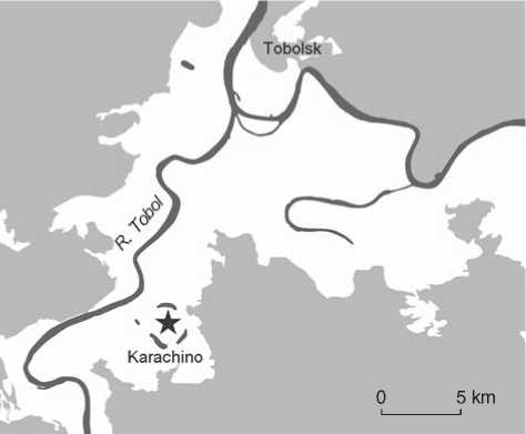
Fig. 1. Location of the research site.
by cartridges from muskets found on the southeastern shore of the island (Fig. 2) (Matveeva, Nagibin, 2014: 31). An excavation trench was made for exploring a dugout that was discovered in 1983.
Research object. This archaeological site is located 1 km to the west of the village of Karachino in the Tobolsky District of the Tyumen Region, on an unflooded wooded ridge of the right bank floodplain of the Tobol River, 30 km upstream of the city of Tobolsk (coordinates: 58°01′20.8′′N, 68°08′42.8′′E). It was discovered by an exploratory trench made by Parkhimovich, who was told by the locals about plowed Yermak dugouts inside the arch of Karachinsky Lake, but he, himself, studied the Karachin town site in 1982– 1983—a settlement of the 18th century consisting of ground dwellings, 240 m to the southwest of our site (Fig. 2) (Parkhimovich, 1985: 236).
On an area of 122.5 m2, we uncovered a log structure, which was only slightly affected by the excavation of the Ural Archaeological Expedition in 1983. Although we made 15 trenches 10–15 m in length, we did not find other dwellings within a radius of 200 m from the structure. Three lower layers and partly a fourth layer of logs, located at a depth of about 2 m from the native soil, have survived from the original framework (Fig. 3). Clay filling 0.2–0.4 m wide and 0.3 m high was found between the walls and the native soil. This layer protected the structure from the freezing of the walls in the winter and from flooding in the spring. The dwelling was divided by a log partition into two rooms of 12.6 m2 (eastern room) and 10.6 m2 (western room). Mixed soil was found under the partition, and below this soil, on both sides of the partition logs, the remains of a stove were discovered in the form of thick layers of fairly uniform calcined soil and thin layers of charcoal,
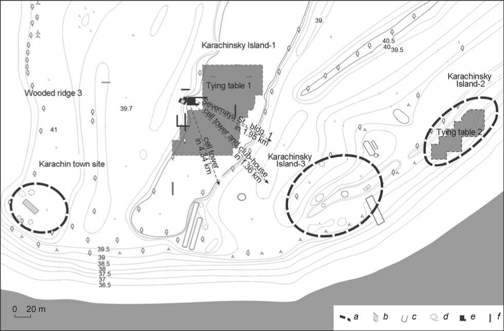
Fig. 2. Layout plan of the research area.
a – boundaries of the monuments; b – excavations of S.G. Parkhimovich; c – anthropogenic disturbances; d – dugouts; e – excavation area of the Tyumen Archaeological Expedition of 2014; f – exploratory trenches of the Tyumen Archaeological Expedition of 2014.
ranging from 10 cm in thickness at the edges to 40 cm in the middle (Fig. 4). The calcined soil contained many sintered pieces of clay, but there were no remains of bricks. Among the orange lenses of calcination, fragments of slag and metal alloy, nine fragments of weakly baked Russian pottery, and a burnisher made from a shard, were found (Fig. 5). It is possible that broken metal objects were repaired or remelted there. Decay from a wooden spatula was discovered next to the remains of the stove.
At the level of the native soil, the dugout had a rectangular shape measuring 9.5 to 10 × 4.5 to 5.0 m. Steps of various heights and widths were located along the perimeter of the walls. The floor had an overall inclination in the western direction towards the slope of the ridge. A cellar was found to the east of the stove remains, consisting of a pit of irregular oval shape measuring 2.8 × 2.1 m in plan. The remains of a frame made of logs or half-logs 12–16 cm wide, outlining the perimeter of the structure, indicate the presence of a cover, which rested upon the frame. The bottom of this pit was uneven; the central part was deepened by 0.40 m on the western side, and by 0.64 m on the eastern side from the level of the continental floor of the structure. The filling of the pit included several layers and strata. The stove might have fallen onto the cover of the cellar during the fire and filled it with its fragments.
Buried soil from the time when the log structure was built, was unearthed in the southwestern wall of the excavation pit under the discharged soil from the dwelling pit, and its comprehensive study was carried out. A cross-section of the background exposed soil was studied 200 m to the south of the excavation pit (coordinates: 58°01′18.9′′N, 68°08′41.9′′E). Both soils belong to the alluvial meadow acid subtype (Klassifikatsiya…, 1977: 196).
Methods
For relative dating of the object, the characteristics of pottery identified during the analysis of materials from the excavations in Tobolsk (Anoshko, Seliverstova, 2009; Matveeva, Anoshko, Dolgikh, 2014) were used. Samples for dendrochronological analysis were
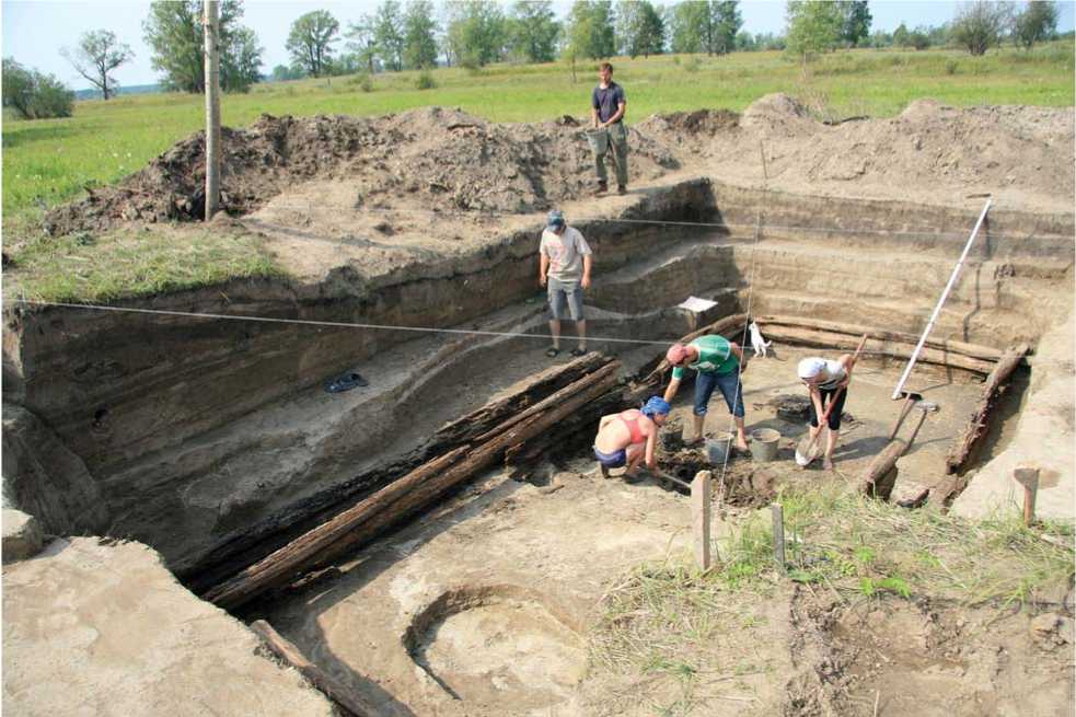
Fig. 3. Cleaning up of the dugout filling.
taken*. Two samples of wood were sent to the laboratory of the University of Arizona (USA) for dating using the AMS method.
The research of paleosoils is based on the pedologic-archaeological method (Demkin, 1997: 37). Its essence is combined analysis of background soils and soils buried under archaeological monuments, whose construction time can be determined by the methods of archaeology. Laboratory research and comparative analysis of the distribution of twelve elements: phosphorus (P), calcium (Ca), magnesium (Mg), manganese (Mn), mercury (Hg), zinc (Zn), copper (Cu), lead (Pb), nickel (Ni), cadmium (Cd), cobalt (Co), and strontium (Sr) in the profiles of buried and background soils have been carried out. The content of Ca, Mg, Mn, Zn, Cu, Pb, Ni, Cd, Co, and Sr was determined using atomic absorption spectrometry with flame atomization on SHIMADZU AA-6300; the content of P was identified using the photometric method on a photocolorimeter KFK-3 “ZOMZ”; the content of Hg was established using the atomic absorption method on a mercury analyzer RA-915M with attachment RP-91S.
Findings and discussion
Historical and archaeological interpretation . Let us consider how objective data can confirm or disprove the information from the chronicles. A ditch was found around the dugout, which may have been the base of a palisade. The building did not only have two rooms, but also had a double framework (“framework inside of a framework”) in its eastern part, of which two or three layers of logs with a diameter not exceeding 22 cm have been preserved (see Fig. 3). This room most likely was residential, and the western room with a single framework might have been used for manufacturing purposes. The remains of wooden planking probably under the foundation of the stove, have survived. We assume that the entire structure was coated with a thick layer of clay. After the fire, the remains of the dwelling were leveled, and the logs of the inner partition of the
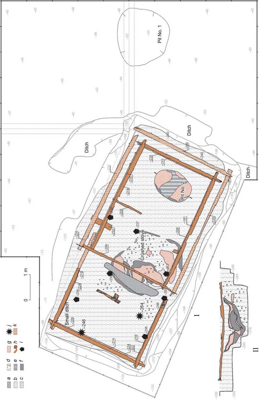
Fig. 4. Plan of the dugout (I) and the cross-section of the stove remains along the partition between the rooms; view from the northwest (II). a – excavation area of the Ural Archaeological Expedition; b – discharged soil; c – gray layer; d – dark gray mixed layer; e – carbonaceous mixed layer; f – carbonaceous layer; g – calcination; h – wood; i – pottery fragment; j – metal object; k – lower level of the dugout.
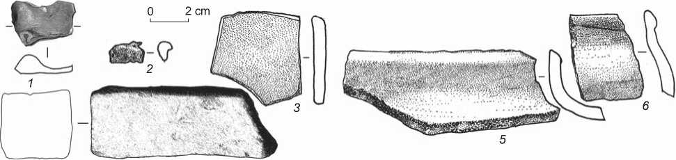
Fig. 5 . Finds from the dugout.
1 , 3 , 5 , 6 – clay; 2 – metal; 4 – stone.
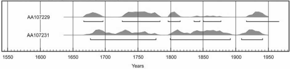
Fig. 6. Diagram of the calibrated dates of wood from the dugout.
dwelling were laid on top of them (Fig. 4). Stoves on wooden planking are known from Russian house building of the 16th–17th centuries. The remains of similar structures have been found in building No. 13 of the lower construction horizon in Mangazeya (Parkhimovich, Vizgalov, 2014: 650). According to morphological and technological features, the pottery discovered in the dugout belongs to the earliest group of Russian pottery that occurs in the layers of the 17th century in the historical part of Tobolsk (Anoshko, Seliverstova, 2009).
Dates of 157 ± 19 (AA107229) and 134 ± 22 BP (AA107231) were obtained from cellulose from two samples of wood. The cumulative interval of their calibrated dates is the late 17th–18th century (Fig. 6). However, since low solar activity occurred in the period of 1630–1750, which led to the formation of the Maunder minimum for the 14C isotope, the radiocarbon age obtained for this historical segment will be later than the real age of the sample*. Therefore, we believe that the dugout under investigation should be dated to the second half of the 17th century.
Judging by the spatial and stratigraphic data, and material evidence, the building existed for a short time and ceased to function because of the fire which is indicated by the lenses of calcination and charcoal in the lower part of the filling, as well as burned logs of the framework. After the fire, the house was repaired, but was used sporadically, as indicated by the small number of discovered artifacts and small amount of household garbage and kitchen waste. In our opinion, the dwelling was built in a dry period, when the island was not flooded. After a short time it turned out to be under water, and the top part of the log structure was washed away.
In general, archaeological observations indicate that the dugout under investigation was used twice in the winter season and this winter dwelling most likely functioned during the initial period of the Russian development of Siberia. Traces of battle (remains of the weapons from the period under discussion) were found nearby on the natural levee (Matveeva, Nagibin, 2014: 31).
This winter dwelling of some group of the Russian population of the mid-17th century is located in an area with semi-hydromorphic natural conditions, characterized by periodic inundation associated with freshets and seasonal flooding. It has been established
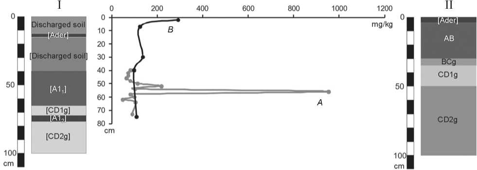
Fig. 7. Distribution of phosphorus (P2O5) according to the profiles of the buried ( A ) and background ( B ) soil. I – soil section under the discharged soil from the pit of the structure; II – section of the background exposed soil.
that the dwelling was built and operated during the period when the territory was not flooded during the year. The dwelling was built into the slope of the natural levee facing the inner part of the island, which provided protection from adverse natural phenomena and wild animals.
Morphological structure of soils . A comparative analysis of the buried and background soils has revealed a number of similar features and differences which did not exceed the indexes of the soil subtype. It has been established that the profile under the discharged soil from the dwelling pit contained two humus horizons of different ages: [A11]* (40–65 cm) and [A12] (72–76 cm). The upper horizon [A11] belongs to the time when the winter dwelling was built. This soil is characterized by a darker color, heavy granulometric composition, as well as better defined structure. For the rest of the morphological features, no significant differences have been observed. Notably, the soil profiles did not react with 10 % hydrochloric acid (HCl).
Distribution of chemical elements in the soils . A comparative analysis was carried out for humus horizons [A11] and AB of the buried and background soils. The most noticeable differences have been observed for phosphorus (Fig. 7). In the buried soil, its content was 955 mg/kg of soil, which is seven and a half times higher than the phosphorus content in the background soil. The concentration of calcium in the paleosoil was also higher and reached 6600 mg/kg as opposed to 1300 mg/kg of the baseline concentration. The concentration of magnesium in the buried soil was
2.5 times higher than in the background soil (6300 and 2300 mg/kg, respectively).
The distribution of metals is of special interest. The concentration of zinc in the paleosoil was 65 mg/kg as opposed to 43 mg/kg in the background soil; the concentration of nickel was 15 and 9 mg/kg; the concentration of strontium was 5.5 and 3 mg/kg; the concentration of lead in the buried soil was ten times higher than the baseline concentration (10 and 1 mg/kg, respectively); the concentration of copper was two times higher (2.5 and 1.2 mg/kg), as with cadmium (0.7 and 0.3 mg/kg), and the concentration of cobalt was three times higher (6.2 and 2.2 mg/kg). No significant differences were found in the distribution of manganese and mercury.
Thus, the humus horizon of the buried soil [А11] constituted a geochemical barrier where the accumulation of chemical elements resulting from the economic activities took place.
Reconstruction of economic activities . The study of the general geomorphological situation in the area under consideration as well as the stratigraphy and planigraphy of the site made it possible to establish that the dwelling was built into the highest place of the natural levee. The upper boundary of the humus horizon [A11] was the boundary of the daytime surface at the time when the winter dwelling was built. We assume that the soil of that time experienced anthropogenic impact until it was sealed. Thus, it seems possible to suggest some considerations on the economic activities of the Russian settlers in the 17th century.
The high content of biogenic elements (phosphorus, calcium, and magnesium) may indicate cattle breeding in the economical system of the population, resulting in the use of the associated foods (meat, milk). Given the good preservation of the paleosoil, the sufficient height of the discharged soil which was sealed, and absence of the obvious traces of diagenesis, we may assume that phosphorus was mainly accumulated from to the livelihood of the dwellers, for example, during meat cutting or leaving waste (cattle might have been kept near the dwelling). In addition, prolonged grazing in this area in the time preceding the construction of the dugout might have led to formation of another stable zone of high concentration of biogenic elements, which is observed in the lower part of the pedologic-archaeological cross-section. Thus, prior to the appearance of the Russians, there were some elements of the economic infrastructure of the Tatars present in this area. Indirectly, this is confirmed by the historical sources about the capturing of booty, as well as S.U. Remezov’s illustration of herds of cattle and horses grazing on the island in Article 53, dedicated to the capture of the Karacha’s ulus (Remezovskaya letopis, 2006: Vol. 2, 157).
High concentration of zinc, copper, lead, nickel, cadmium, cobalt, and strontium may indicate artisanal metallurgical activities of the population who might have been engaged in repairing household objects. Elevated concentrations of copper and zinc indicate that brass objects (copper and zinc alloy) were used in the household. High concentrations of lead may indicate the production of bullets. Nickel, cobalt, cadmium, and strontium are used in metallurgy as alloying additives. The dwellers might well have repaired high-grade steel products; most likely, these were bladed weapons.
Conclusion
Thus, field archaeological studies have not revealed the encampment of Yermak’s detachment on the most dry and elevated stretch of the Karachinsky Island. It has been established that the island was regularly flooded and was not suitable not only for permanent, but also for temporary residence of a large group of people. We think that discovery of such an encampment in the future is unlikely. The studied winter dwelling belonged to another group of Russian pioneers who moved to Siberia half a century after the Cossacks of Yermak, and the memory of this wintering was reflected in the historical legends about the development of the region. It has been established that the concentrations of ten chemical elements (P, Ca, Mg, Zn, Cu, Pb, Ni, Cd, Co, and Sr) in the humus horizon of the paleosoil exceeded the baseline values by 1.5–10 times. This is associated with the specific aspects of economic activities practiced by the dwellers. Probably, the basis of their economy was cattle breeding and handicrafts, including manufacturing and repairing of weaponry. The obtained geochemical data on the specific features of economic activity of the Russian population of the 17th century in Western Siberia fit well with the archaeological materials and sources on the culture of the pioneers.
It seems that our study confirms the idea of R.G. Skrynnikov on the lightning-fast campaign of the Cossacks from the Stroganov towns to Qashliq without spending a winter. Such a course of the military campaign also seems to be most tactically justified in the conditions of weak resistance of Tatar forces, fragmented due to the participation of Mametkul’s troops in the raid to the Cis-Urals. In addition, data have been obtained that indirectly confirm the reports of the chronicles on the battle of the Cossacks at the headquarters of Karacha and capturing of spoils.
References The Russian pioneers' winter camp on Karachinsky island, the Lower Tobol river, Western Siberia
- Anoshko O.M., Seliverstova T.V. 2009 Kharakteristika russkoy goncharnoy posudy iz raskopok na territorii Verkhnego posada g. Tobolska. Vestnik Tyumenskogo gosudarstvennogo universiteta, No. 7: 80–90.
- Demkin V.A. 1997 Paleopochvovedeniye i arkheologiya: Integratsiya v izuchenii istorii prirody i obshchestva. Pushchino: ONTI PNT RAN.
- Dergacheva-Skop E.I. 1965 S.U. Remezov i ego “Istoriya sibirskaya”: Cand. Sc. (Philology) Dissertation. Leningrad. Klassifi katsiya i diagnostika pochv SSSR. 1977 Moscow: Kolos.
- Matveeva N.P., Alieva T.A. 2014 Issledovaniye pamyatnika Tsarevo gorodishche v istoricheskoy chasti g. Tyumeni v 2011 g. In Trudy IV Vseros. arkheol. syezda v Kazani, vol. III. Kazan: Otechestvo, pp. 640–644.
- Matveeva N.P., Anoshko O.M. 2014 Problemy i perspektivy izucheniya sibirskogo pokhoda Yermaka na osnove kompleksnogo istochnikovedeniya. In Prisoyedineniye Sibiri k Rossii: Noviye danniye: Materialy Vseros. konf. Tyumen: Izd. Tyum. Gos. Univ., pp. 16–26.
- Matveeva N.P., Anoshko O.M., Dolgikh A.S. 2014 Raskopki zemlyanki na Karachinskom ostrove. In Prisoyedineniye Sibiri k Rossii: Noviye danniye: Materialy Vseros. konf. Tyumen: Izd. Tyum. Gos. Univ., pp. 26–28.
- Matveeva N.P., Nagibin G.F. 2014 Raboty po obnaruzheniyu polya bitvy Yermaka s tatarskoy druzhinoy na Karachinskom ostrove. In Prisoyedineniye Sibiri k Rossii: Noviye danniye: Materialy Vseros. konf. Tyumen: Izd. Tyum. Gos. Univ., pp. 29–33.
- Mogilnikov V.A. 2004 O vremeni zaseleniya gorodishcha Isker. In Tobolskiy khronograf, iss. 4. Yekaterinburg: Ural. rabochiy, pp. 117–119.
- Parkhimovich S.G. 1984 Raskopki russkikh srednevekovykh pamyatnikov na Urale I v Zapadnoy Sibiri. In Arkheologicheskiye otkrytiya 1982 goda. Moscow: Nauka, p. 169.
- Parkhimovich S.G. 1985 Issledovaniya pamyatnikov Zauralya i Zapadnoy Sibiri. In Arkheologicheskiye otkrytiya 1983 goda. Moscow: Nauka, pp. 235–236.
- Parkhimovich S.G., Vizgalov G.P. 2014 Malogabaritniye postroyki posada Mangazei. In Trudy Vseros. arkheol. syezda v Kazani, vol. III. Kazan: Otechestvo, pp. 648–651.
- Polnoye sobraniye russkikh letopisey. 1987 Vol. 36: Sibirskiye letopisi. Ch. 1: Gruppa Yesipovskoy letopisi. Moscow: Nauka.
- Rafi kova T.N. 2011 Rezultaty izucheniya Tsareva gorodishcha (2007–2009 gg.). In Istoriya, ekonomika i kultura srednevekovykh tyurksko-tatarskikh gosudarstv Zapadnoy Sibiri. Kurgan: Kurgan. Gos. Univ., pp. 11–15.
- Remezovskaya letopis. 2006 V 2 t. Vol. 1: Faksimile. Vol. 2: Istoriya Sibirskaya. Letopis Sibirskaya, kratkaya Kungurskaya: Issledovaniye. Tobolsk: Obshchestv. fond “Vozrozhdeniye Tobolska”.
- Romodanovskaya E.K. 2002 Izbranniye trudy: Sibir i literatura XVII v. Novosibirsk: Nauka.
- Sergeev V.I. 1959 K voprosu o pokhode v Sibir druzhiny Yermaka. Voprosy istorii, No. 1: 126–130.
- Sibirskiye letopisi: Kratkaya Sibirskaya letopis (Kungurskaya). 2008 Ryazan: Aleksandriya.
- Skrynnikov R.G. 1986 Sibirskaya ekspeditsiya Yermaka. 2nd edition. Novosibirsk: Nauka.
