Unfortified settlements of the Cheptsa culture (9th-13th centuries): ambiguity of interpretation and delimitation of boundaries
: ambiguity of interpretation and delimitation of boundaries")
Author: Zhurbin I.V.
Journal: Archaeology, Ethnology & Anthropology of Eurasia @journal-aeae-en
Section: The metal ages and medieval period
Article in issue: 1 т.49, 2021.
Free access
Short address: https://sciup.org/145146233
IDR: 145146233
Text of the article Unfortified settlements of the Cheptsa culture (9th-13th centuries): ambiguity of interpretation and delimitation of boundaries
Medieval settlements in the Cheptsa River basin were first systematically described at the end of the 19th century by A.A. Spitsyn (1893) and N.G. Pervukhin (1896). Starting from 1969, this region has been the main focus of research conducted by the Udmurt Institute of History, Language, and Literature of the Ural Branch, Russian Academy of Sciences. Over 300 archaeological sites are known there, including fortified and unfortified rural settlements, burial grounds, hoards, and isolated find localities (Arkheologicheskaya karta…, 2004).
At the turn of the 1st to 2nd millennia AD (Cheptsa culture), the center of settlement of the region was located in the middle reaches of the Cheptsa River, including its right and left tributaries. Over half the fortified settlements are concentrated on the high right bank of the river. Tributary streams and ravines cut the bank. This specific landscape situation was favorable
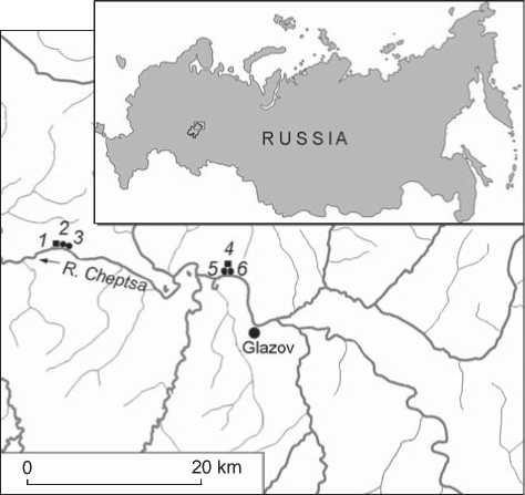
Fig. 1 . Settlements of the Cheptsa culture of the 9th– 13th centuries.
1 – Kushman settlement of Uchkakar; 2 – Kushmanskoye III settlement; 3 – Kushmanskoye II settlement; 4 – Bogatyrka settlement of Utemkar; 5 – Nizhnebogatyrskoye II settlement; 6 – Nizhnebogatyrskoye I settlement.
to the construction of fortified settlements. The network of fortified settlements was developed there, and villages were established nearby. The latter were located on gently sloped hills or on fluvial terraces, near convenient descents to the river or brook. Rural Cheptsa settlements have been poorly investigated: small-scale archaeological excavations have been conducted at only two out of 34 settlements, and test pits have been made at 17 of them. At all other sites, artifacts have been collected from the ground surface. All that can be done with this amount of information is to confirm the presence of a cultural layer, attribute it to a certain culture, and assess its age. That is why archaeological methods must be supplemented by scientific analyses. Examined Kushmanskoye II and III, and Nizhnebogatyrskoye I, belonged to different settlement complexes (Fig. 1). Both are ambiguous despite having been excavated to a certain extent.
Kushmanskoye III
This site was discovered by G.T. Kondratieva (Otchet…, 1959). Animal bones and fragments of hand-made pottery were found on tilled ground (Arkheologicheskaya karta…, 2004: 202, 203). The settlement is situated 200 m east of the outer fortification line of Uchkakar (Mezhdistsiplinarnye issledovaniya…, 2018) and separated from its unprotected external part by a ravine. The absence of salient signs of defensive structures, as well as the proximity to the large fortified settlement, suggest an unfortified village. It is included into the Kushman complex of sites (Ivanova, Kirillov, 2012): the Uchkakar fortified settlement, three unfortified villages, and a burial ground. Deep gullies and the abrupt slope of the Cheptsa riverbank delimit the territory of Kushmanskoye III on the east, west, and south. In 2012, a test pit was made in the central part of the site, and a cultural layer up to 0.7 m thick containing artifacts from the 9th– 12th centuries was revealed (Kirillov, 2012). This pilot archaeological survey confirmed the presence of a medieval settlement and its attribution to the Cheptsa culture. On the basis of landscape features, the site’s boundaries were tentatively established (Kirillov, 2011), though its structure and layout remained unknown. The results of further multidisciplinary studies have been described in detail elsewhere (Zhurbin et al., 2019), so they are given here in a condensed form. Our research identified two lines of defensive structures, invisible in the relief. This has enabled us to define the structure of the settlement and to substantiate revision of the site’s typological status in the register of state-protected archaeological resources. Multidisciplinary studies revealed clay platforms of houses, and round pits filled with material of different kinds (Ivanova, 2016, 2017). In the promontory part of the settlement, constructions were arranged in parallel rows oriented along the axis of the promontory. Before the inner fortification line and in the outer part of the site, the orientation of the rows changes: structures are parallel to fortifications (Zhurbin et al., 2019). The same linear layout was recorded at other settlements of the Cheptsa culture (Zhurbin, 2020; Ivanova, Zhurbin, 2014).
Kushmanskoye II
This site was also discovered by G.T. Kondratieva (Otchet…, 1959). Animal bones and fragments of hand-made pottery were detected lying on tilled ground. A ravine separates this site from Kushmanskoye III. Both settlements demonstrate similar external features. Natural boundaries delimit Kushmanskoye II on the south, east, and west (Arkheologicheskaya karta…, 2004: 202).
In the course of preliminary study (Kirillov, 2011), five test pits were made in different parts of the settlement (Fig. 2). A similar situation can be observed in test pits 1–4: the tilled horizon overlies soil-forming sediment consisting of Permian clays with limestone debris. A cultural layer is present only in test pit 5, located in a small valley, in the zone of accumulation of fine-textured soil. Here, the tilled horizon is underlain by the cultural layer of a recent village: grayish-brown heavy loam varying in color, with inclusions of stones and fine debris. This layer covers buried soil—dark gray, dense, and heavy loam. Even lower, directly above the soil-forming material, an inhomogeneous layer of gray loam with fragments of subsoil clay and numerous charcoal pieces can be observed. Exactly this layer indicates that this territory was inhabited during the Middle Ages. Archaeological remains were found only in test pits 1, 2, and 5. They are represented mostly by wheel-thrown pottery from the 17th–19th centuries.
Only two fragments of hand-made ceramics of the 10th–12th centuries were unearthed. Thus, it has been found out that the medieval cultural layer is not present throughout the site. Cumulative elements of relief contain evidence of a settlement attributable to the 17th–19th centuries.
Obviously, these results do not rule out the possibility that underground parts of medieval structures have been preserved. To find these, geophysical methods, including resistivity and magnetometry surveys, ground-penetrating radar, and electrical resistivity tomography, were employed. At a rated depth of 0.44–0.60 m, georadar survey (Fig. 3, a ) revealed two parallel linear anomalies intersecting the entire geophysical survey area from NW to SE (possibly, sides of the road or irrigation structures), as well as adjoining two compact groups of mutually perpendicular linear anomalies (possibly, strip foundation of buildings or earth fill along the walls). The shapes and locations of the anomalies
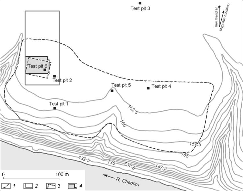
Fig. 2 . Digital model of Kushmanskoye II landforms; location of archaeological and geophysical study areas (basis by N.G. Vorobieva, “Finko” LLC, supplemented by R.P. Petrov, Udmurt Federal Research Center, Ural Branch, Russian Academy of Sciences). The altimetric system is conventional.
1 – boundaries of the settlement according to landscape features (after (Kirillov, 2011: Fig. 79)); 2–4 – boundaries of areas examined by ground-penetrating radar ( 2 ), magnetic ( 3 ), and resistivity ( 4 ) surveys.
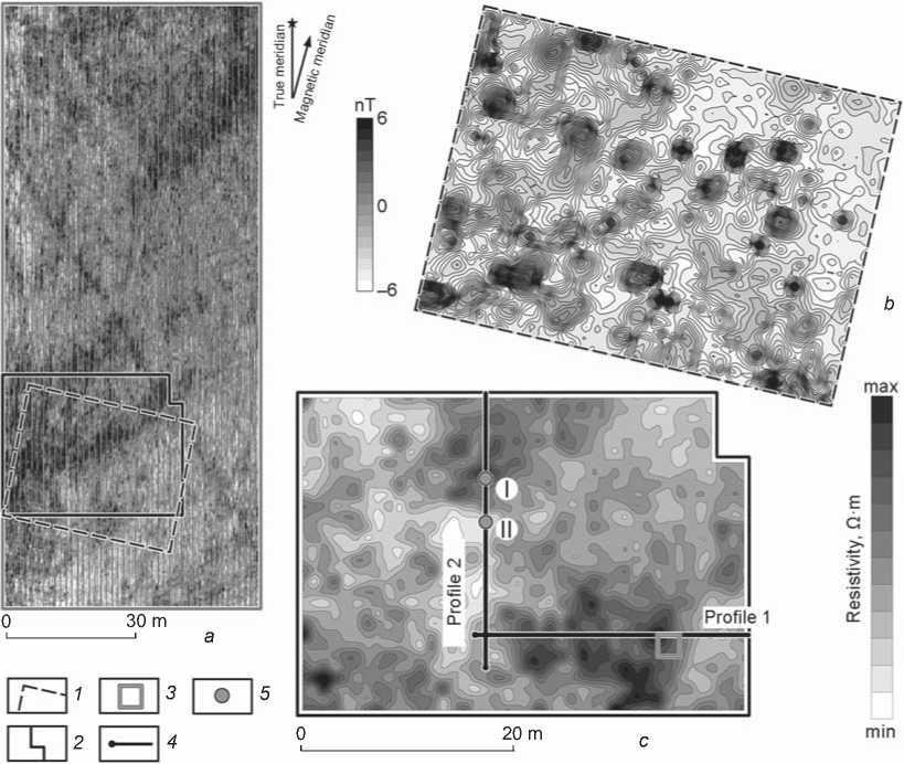
Fig. 3. Results of multidisciplinary studies of Kushmanskoye II.
a – ground-penetrating radar survey (rated depth 0.59 m; V.G. Bezdudny, Laboratory of Archaeological Geophysics, Rostov-on-Don); b – magnetogram (V.G. Bezdudny); c – resistivity survey.
1 , 2 – boundaries of magnetic ( 1 ) and resistivity ( 2 ) surveys; 3 – test pit; 4 – line of electrical resistivity tomography profile;
5 – soil core.
suggest that these objects were not associated with the medieval settlement. Magnetometry and resistivity surveys were conducted in the area where structures of various types were located. The collation of ground-penetrating radar and magnetic maps demonstrates their similarity. The magnetometry survey (Fig. 3, b ) revealed linear structures in the northwestern part of the prospected area, which coincided with linear anomalies shown by the radar. Three zones of high resistivity were recorded through resistivity survey (Fig. 3, c ). Geoelectric profiles demonstrated contrasting upper layers associated with these anomalies, and an absence of humic soil layer between them (western and eastern parts of profile 1, Fig. 4, a ; southern part of profile 2, Fig. 4, b ). In most cases, the coordinate comparison of local anomalies on electric and magnetic maps reveals no correspondence. Therefore, the presence of medieval features is questionable.
Since the results seemed to be ambiguous, soil drilling was conducted in several places along the line of profile 2 (see Fig. 3, c ), “crossing” one of the high resistivity zones. Test pit 6 was made in another zone (Ivanova, 2016). These anomalies were also revealed through magnetometry survey. As excavations and soil drilling (see Fig. 4, c ) have shown, the geophysical anomalies are associated with local zones with high content of carbonates. In core I, a carbonate platform lies at a depth starting from 0.3–0.4 m. The situation is quite different in core II, so the resistivity is low in this place, contrasting sharply with the local zone of high resistivity. A similar picture can be observed in test pit 6 (see Fig. 3, c ; 4, a ): a layer of limestone lies in the northwestern corner under the tilled horizon. It is possible that geological peculiarities are responsible also for other local anomalies recorded at Kushmanskoye II. Archaeological remains from test pit 6 consist
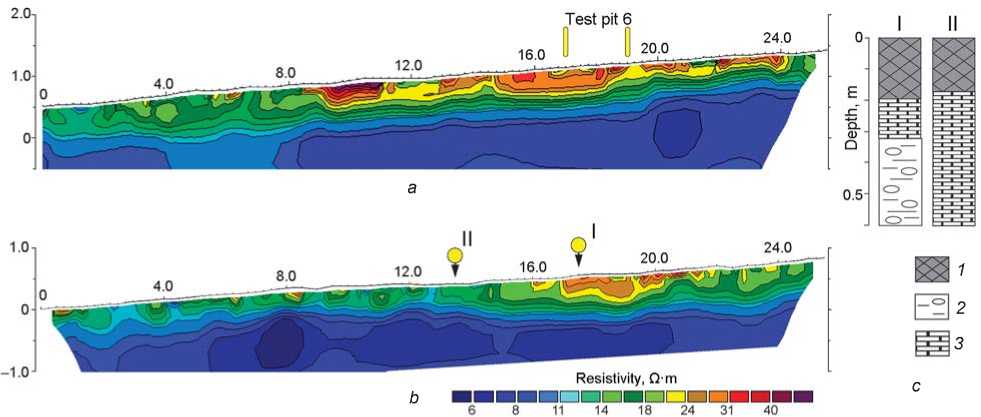
Fig. 4. Geoelectric sections along profiles 1 ( a ), 2 ( b ), and lithological structure of cores (A.V. Borisov, Institute of Physicochemical and Biological Problems of Soil Science, Russian Academy of Sciences, Pushchino) ( c ).
1 – tilled horizon (heavy loam); 2 – limestone slab; 3 – subsoil clay.
mostly of ceramic fragments (Ibid.). Only two of them are typical of the Cheptsa culture (9th– 13th centuries), while the other ten are pieces of wheel-thrown vessels attributable to the 18th–19th centuries. Such a situation agrees with finds from other test pits. Consequently, the presence of a medieval site at that place is not supported. Isolated fragments of handmade vessels and the lack of structures likely suggest that the area was part of a manufacturing and trade zone associated with nearby settlements—rural (Kushmanskoye III) and fortified (Uchkakar).
Nizhnebogatyrskoye I
This site is situated on the right bank of the Cheptsa River, near Nizhnyaya Bogatyrka village (Arkheologicheskaya karta…, 2004: 157, 158). The settlement occupies a large promontory of the first terrace of the bedrock riverbank. The promontory is delimited by a ravine on the west, a steep bank of the Cheptsa on the south, and by the next steeper ledge of the terrace on the north (Fig. 5). Until recently, the surface of the site was tilled. A modern road passes between the northern boundary of the site and the southern base of the promontory part of the high bedrock river terrace, where the Utemkar fortified settlement was located (Ibid.: 142). Nizhnebogatyrskoye I, Nizhnebogatyrskoye II (Ibid.: 158), and Utemkar constitute a single archaeological complex.
N.G. Pervukhin, describing Utemkar (1896: 76–78), was the first to mention the site of Nizhnebogatyrskoye I, though he did not regard it as a separate settlement. The author assumed that this was the concentration place of habitation deposits, which had been “washed down the slope in the southeastern direction, across the road and toward the Cheptsa riverbank, where they had partly mixed with sand” (Ibid.: 78). Notably, Pervukhin mentioned a road as a landmark. Supposedly, the road ran farther south than the modern one (see below). Medieval artifacts were encountered throughout the slope, right down to the river. In 1959, Nizhnebogatyrskoye I and II were identified as separate archaeological sites (Otchet…, 1959). Further investigations concentrated on surveying and collecting artifacts from the surface.
The ambiguity of interpretation of Nizhnebogatyrskoye I required geophysical prospection. The results thus obtained were corroborated by soil drilling and archaeological excavations (Fig. 5). Magnetometry survey was the principal method employed. The northern boundary of the prospected area passed along the modern road. In its western part, where the highest density of magnetic anomalies was recorded, a resistivity survey and electrical resistivity tomography were conducted. The choice of the place for a geophysical survey was motivated by the distribution pattern of surface finds (Derendyaev, 2016: Fig. 6).
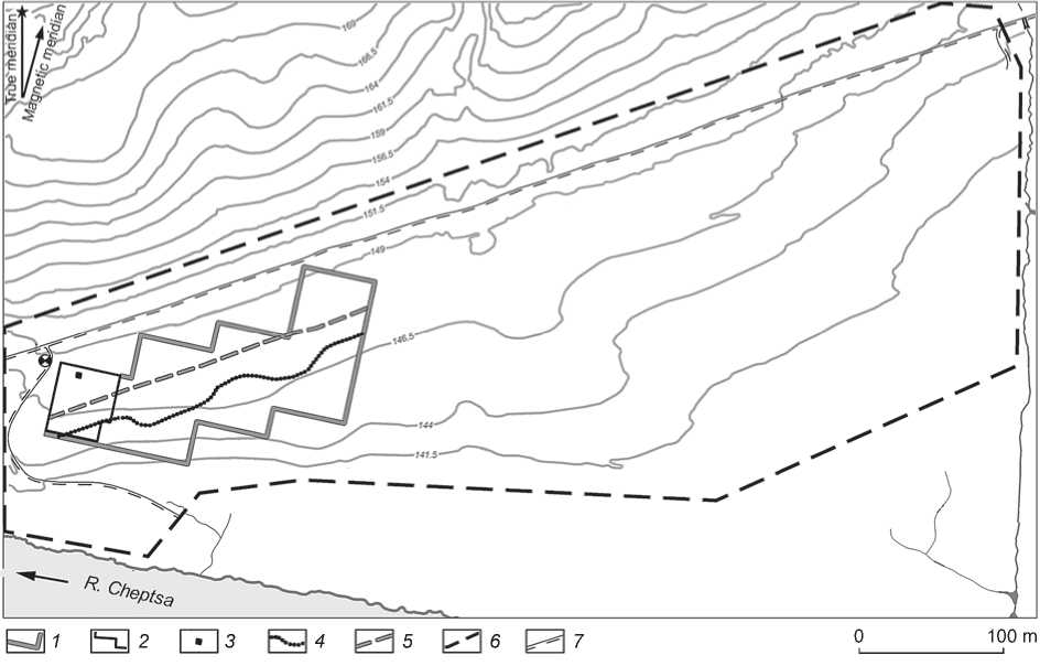
Fig. 5. Digital model of Nizhnebogatyrskoye I landforms; location of archaeological and geophysical study areas (basis by N.G. Vorobieva, “Finko” LLC, supplemented by R.P. Petrov, Udmurt Federal Research Center, Ural Branch, Russian Academy of Sciences). The altimetric system is conventional.
1 , 2 – boundaries of magnetic ( 1 ) and resistivity ( 2 ) surveys; 3 – excavation; 4 – boundaries of the settlement according to geophysical data; 5 – presumable line of the 19th century road; 6 – boundaries of the settlement according to landscape features (after (Derendyaev, 2016: Fig. 5)); 7 – modern road.
The magnetogram (Fig. 6, a ) demonstrates linear zones of high resistivity oriented along the SW-NE line. Their location and orientation clearly agree with relief changes. The area is flattened by modern tillage, though initially it had mesorelief in the form of riverbed-adjacent ridges typical for flood-plains. Therefore, most linear anomalies correspond to zones of accumulation of fine-textured soil transported into negative landforms. One of these, running along the whole area of magnetic survey, is apparently wider and more intensive than others. The geoelectric profile “crossing” this anomaly (range of 16–24 m; Fig. 6, b ) also shows deposits of a different type. These facts allow us to associate the feature with the road, which was a topographic landmark in Pervukhun’s description of the area with disturbed habitation deposits of Utemkar. Clearly, this suggestion must be tested by excavations.
The magnetic survey (Fig. 6, a) recorded a high concentration of anomalies in the areas adjacent to the modern road. Dipolar magnetic anomalies, possibly associated with deepened objects containing pyrogenically modified matter, as well as high-magnetization zones, are present there. They are traced on a heterogeneous background formed by numerous, chaotically located low-amplitude anomalies. A structure of this sort normally corresponds to a cultural layer containing artifacts with high magnetization (ceramics, slag, oven stones). Quite a different situation is observed closer to the Cheptsa River: rare areal positive anomalies are visible on a rather homogenous background. Judging by the past findings at sites destroyed by tillage, the boundary between these areas coincides with that of the habitation deposits (see Fig. 5; 6, a).
The resistivity survey revealed no local anomalies associated with layout features. Anomalous high resistivity zones of an indefinite shape may be connected with sections of a thick cultural layer. Two such sections correspond to dipolar anomalies recorded through the magnetic survey. Soil drilling revealed culture-bearing deposits of considerable
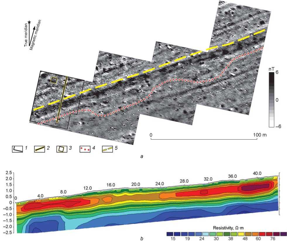
Fig. 6 . Results of geophysical studies of Nizhnebogatyrskoye I.
а – magnetogram (V.G. Bezdudny, Laboratory of Archaeological Geophysics, Rostov-on-Don); b – geoelectric section.
1 – boundary of resistivity survey; 2 – line of electrical resistivity tomography profile; 3 – excavation; 4 – boundaries of the settlement according to geophysical data; 5 – presumable line of the 19th century road.
thickness (up to 1 m), containing a layer of loam at least 0.3 m thick with ceramics, fragments of charred clay, charcoal, and ash (Emelianova, 2018: Suppl. 4). The presence of dipolar anomalies was determined by the high concentration of such inclusions. Geoelectric profiles show no layout features either. Soil drilling confirms this observation. The differential characteristic is the absence of evidence of heating facilities or visible layers of baked and compacted clay typical of other sites of the Cheptsa culture. It is possible that in the study area, there were no permanent buildings with clay platforms under hearths or ovens. This may be explained by the floodplain character of the area and periodical flooding of the low terrace.
A test pit (see Fig. 6, a ) was made for archaeological evaluation of the revealed situation. Regrettably, owing to limited time and adverse weather conditions, excavations were ceased at a depth of 0.5 m from the surface (Ibid.: 3). The collection of finds comprises 5731 artifacts. Most numerous are fragments of handmade pottery, crucibles, and clay coating. There are also bone fragments, slag, and artifacts made of bone, stone, iron, and nonferrous metals. On the basis of the archaeological remains, Nizhnebogatyrskoye I can be tentatively attributed to the Polom and Cheptsa cultures of the 7th–12th centuries. Because the excavation is small and has not been examined in full, some features of its layout may have remained undetected.
Thus, the main result of the multidisciplinary research is allocation of the southern boundary of the cultural layer at the site (see Fig. 5). Our findings do not rule out the Pervukhin’s idea that habitation deposits of Utemkar had accumulated in that place. If a separate site did exist, then the examined area was part of its fringes. The main feature differentiating Nizhnebogatyrskoye I from other examined settlements of the Cheptsa culture is the absence of traces of large permanent buildings.
Conclusions
Examination of three unfortified settlements of the Cheptsa culture produced unexpected results. Unfortified rural settlements have been detected by the presence of surface finds in tilled soil or of cultural layer in test pits, by the conformity of the area to known landscape features, as well as by the absence of salient signs of defensive structures. Multidisciplinary studies showed, however, that the absence of salient fortifications does not always indicate an unfortified site. For example, at Kushmanskoye III, two fortification lines, possibly destroyed by tillage, were detected. It was also shown there that the absence of layout features does not necessarily indicate the boundary of the site. The area of the household’s periphery is evidenced by changes in the chemical and biological properties of the soil far beyond the outer fortification line of this newly discovered site. Studies at Nizhnebogatyrskoye I, where no fortifications were found, demonstrate that the landscape boundaries of the area do not always coincide with those of the site. Geophysical findings suggest that the habitation area was much smaller than the estimate derived from the pilot archaeological survey. Also, the presence of artifacts on the surface of the tilled field or in the test pit is not enough to conclude that there was a site. The totality of facts resulting from multidisciplinary geophysical, pedological, and archaeological studies at Kushmanskoye II does not support the idea that a medieval site was present in that area.
Acknowledgement
This study was supported by the Russian Foundation for Basic Research, Project No. 18-49-180007 p-a.
