
Assessment of the Current Sanitary and Technical Condition of Irrigation Reservoirs in Azerbaijan
Journal: Bulletin of Science and Practice @bulletennauki
Section: Естественные науки
Article in issue: 9 т.12, 2026.
Free access
The article presents a comprehensive assessment of the current sanitary and technical condition of irrigation reservoirs in Azerbaijan, analyzing the operational characteristics of hydraulic structures, the level of technical deterioration, and the primary risk factors affecting their safe operation. The study aims to determine the condition of reservoirs vital to irrigation systems, identify factors influencing operational reliability, and evaluate the applicability of modern monitoring and management approaches. The research utilizes comparative analysis, a systems approach, statistical assessment methods, hydro-technical observation data, regulatory documentation, and geographic information systems (GIS) combined with remote sensing. Particular attention is given to dam stability, the structural integrity of hydraulic facilities, sediment accumulation, seepage, deformation processes, and key sanitary water quality indicators. Results indicate that prolonged operation, structural wear, sedimentation, and insufficient monitoring contribute to declining safety and efficiency. Conversely, the implementation of digital monitoring, GIS-based analytical tools, and automated systems is essential for improving reliability and sustainability. The scientific novelty lies in the integrated assessment of these reservoirs using contemporary technological frameworks.
Short address: https://sciup.org/14139008
IDS: 14139008 | UDC: 502.1: 631.871 (479.24) | DOI: 10.33619/2414-2948/130/12
Оценка современного санитарно-технического состояния оросительных водохранилищ Азербайджана
Проведена комплексная оценка современного санитарно-технического состояния оросительных водохранилищ Азербайджана, а также проанализированы эксплуатационные особенности гидротехнических сооружений, уровень их технического износа и основные факторы риска, влияющие на безопасность эксплуатации. Основной целью исследования является определение текущего технического и санитарного состояния водохранилищ, играющих важную роль в оросительных системах, выявление факторов, влияющих на эксплуатационную надежность, а также оценка возможностей применения современных методов мониторинга и управления. В ходе исследования использованы методы сравнительного анализа, системного подхода, статистической оценки, материалы гидротехнических наблюдений, нормативно-технические документы, а также данные географических информационных систем (ГИС) и дистанционного зондирования. При оценке технического состояния водохранилищ особое внимание уделено устойчивости плотин, эксплуатационному состоянию гидротехнических сооружений, процессам заиления, фильтрации и деформации, а также санитарным показателям качества воды. Результаты исследования показали, что длительная эксплуатация, технический износ, накопление наносов и недостаточность систем мониторинга приводят к снижению уровня безопасности и эксплуатационной эффективности ряда водохранилищ. Вместе с тем внедрение цифровых технологий мониторинга, ГИС-анализа и автоматизированных систем управления имеет важное значение для оптимизации безопасной и устойчивой эксплуатации водохранилищ. Научная новизна статьи заключается в комплексной оценке санитарно-технического состояния оросительных водохранилищ на основе современных подходов к мониторингу и управлению.
Text of the scientific article Assessment of the Current Sanitary and Technical Condition of Irrigation Reservoirs in Azerbaijan
Бюллетень науки и практики / Bulletin of Science and Practice
At the present stage, the efficient use of water resources and the assurance of water security are considered among the most strategically important issues on a global scale. Climate change, the uneven distribution of precipitation, the increasing anthropogenic impact on water resources, and the growing demand for water in agriculture necessitate the sustainable management of water systems .
In this regard, irrigation reservoirs are regarded as strategically significant infrastructure for regulating water resources, maintaining stable water supply during the vegetation period, and increasing agricultural productivity .
The climatic and hydrological conditions of the Republic of Azerbaijan are characterized by the uneven formation and distribution of water resources across the territory. In most regions of the republic, the low amount of precipitation and the high level of evaporation further increase the importance of artificial irrigation in agriculture [1].
Therefore, irrigation reservoirs established in the country play an important functional role in supplying irrigation water to agricultural lands, regulating seasonal river flow, and managing water resources. The Mingachevir, Shamkir, Yenikend, Araz, and other reservoirs have long served as the principal regulating components of the republic’s irrigation system [8].
In recent years, as a result of the long-term operation of reservoirs, problems such as the technical deterioration of hydraulic engineering structures, the accumulation of silt and sediments, the intensification of deformation and seepage processes, as well as the deterioration of sanitary and ecological conditions, have become increasingly evident .
At the same time, the growing frequency of extreme hydrological events caused by climate change further increases the relevance of issues related to the safe operation and management of reservoirs .
At the current stage, the application of digital monitoring technologies, geographic information systems (GIS), and remote sensing data is of particular importance for the operative assessment of the technical condition of reservoirs, the early identification of risks, and the sustainable management .
The article provides a comprehensive assessment of the current sanitary and technical condition of irrigation reservoirs in Azerbaijan, analyzes existing operational problems and risk factors, and examines the prospects for applying modern monitoring and management approaches. The main objective of the study is to substantiate scientific and practical approaches aimed at ensuring the safe and efficient operation of reservoirs.
Materials and Methods
In the present study, a comprehensive scientific and practical approach was applied to assess the current sanitary and technical condition of irrigation reservoirs in Azerbaijan. The research focused on the hydraulic engineering and operational characteristics of major irrigation reservoirs playing a significant role in the country’s irrigation system, including the Mingachevir, Shamkir, Yenikend, Araz, Jeyranbatan, and other large reservoirs. During the research process, the technical condition, operational features, sanitary-ecological indicators, and the principal risk factors affecting reservoir safety were systematically analyzed. For the implementation of this scientific research, hydrological and technical-statistical data obtained from the relevant state institutions of the Republic of Azerbaijan, regulatory documents related to hydraulic engineering structures, scientific literature sources, and methodological approaches developed by international organizations concerning water security and the operation of hydraulic structures were utilized [8].
In assessing the technical condition of the reservoirs, comparative analyses were carried out based on indicators such as the operational lifespan of hydraulic structures, the structural stability of dams, signs of deformation, seepage processes, silt and sediment accumulation, and the functional condition of water conveyance facilities. The assessment of sanitary conditions included the analysis of water quality indicators, anthropogenic pollution sources, ecological changes observed in coastal zones, and the hydrobiological condition of the reservoirs. In addition, long-term hydrological observation data and meteorological indicators were analyzed to determine the impact of climate change on water resources .
The study employed methods of systems analysis, comparative assessment, statistical analysis, and analytical generalization. To evaluate modern monitoring approaches, the applicability of geographic information systems (GIS), remote sensing data, and digital monitoring technologies was investigated. Based on satellite imagery, analyses were conducted on changes in reservoir surface area, sediment accumulation, and morphodynamic processes occurring within coastal zones .
The methodological framework of the research was based on the principles of safe operation of hydraulic engineering structures, integrated water resources management, and sustainable water supply. As a result of the comprehensive assessment, the current sanitary and technical condition of the irrigation reservoirs was determined, the main operational problems were systematized, and scientific and practical approaches aimed at their optimization were substantiated.
Research Results
Objectives and tasks of the study. The main objective of the research is to provide a comprehensive assessment of the current technical and operational condition of irrigation reservoirs in Azerbaijan, to determine the reliability level of hydraulic engineering structures, and to scientifically analyze the principal risk factors affecting the safe operation of reservoirs. Although the study generally covered the major irrigation reservoirs of the republic, a more detailed assessment of hydrological and technical characteristics was conducted for reservoirs located within the Greater Caucasus hydrological region.
During the study, the technical and operational indicators of reservoirs, the structural condition of hydraulic engineering facilities, the impact of operational lifespan on technical stability, silt and sediment accumulation, filtration and deformation processes, as well as sanitary-ecological risk factors, were comparatively analyzed. In addition, the applicability of modern monitoring technologies and digital management systems was evaluated [8].
The principal objectives of the research included the following: assessment of the technical condition of the major irrigation reservoirs in Azerbaijan; analysis of the functional stability of the main hydraulic engineering structures; determination of the relationship between operational lifespan and technical deterioration; investigation of risk factors affecting sanitary and ecological conditions; identification of the prospects for applying modern monitoring and GIS technologies; and development of scientific and practical recommendations for the safe and sustainable management of reservoirs. The conducted analyses revealed that certain reservoirs operating under long-term conditions demonstrate a relative decline in the technical condition indicators of hydraulic engineering structures. In particular, in basins fed by mountain rivers, intensive sediment inflow and silt accumulation reduce the useful storage capacity and decrease the efficiency of water conveyance systems .
Current technical condition of irrigation reservoirs. Technical and operational characteristics of reservoirs. In the Republic of Azerbaijan, irrigation reservoirs are considered one of the principal hydraulic engineering components of the agricultural water supply system. The majority of large reservoirs operating in the republic were constructed for the purposes of multi-year and seasonal flow regulation, the accumulation of irrigation water, and ensuring the sustainable water supply of agricultural lands. Research demonstrates that the technical and operational condition of reservoirs is directly associated with their construction period, hydrological conditions, sediment inflow intensity, and the level of operational management [8].
During the study, the technical indicators of the Mingachevir, Shamkir, Yenikand, Araz, Takhtakorpu, Shamkirchay, and other major reservoirs were comparatively analyzed. Although the Shamkirchay and Takhtakorpu reservoirs are characterized by relatively higher stability due to the application of modern hydraulic engineering solutions, it was determined that technical deterioration processes have intensified in some reservoirs that have been in operation for longer periods [6, 8].
The principal hydraulic engineering structures of reservoirs include earth-fill and concrete dams, spillway structures, water intake systems, derivation canals, energy dissipation facilities, and bank protection elements. The conducted observations showed that, particularly in structures subjected to long-term operation, the formation of cracks in concrete surfaces, the intensification of filtration processes, and corrosion in metal structures are frequently observed. To assess the technical and operational condition, the integrated technical condition coefficient was applied:
Ktv
I^i Щ x i X^i
here, Ktv is the technical condition coefficient; xi is the evaluated technical parameter; and ai is the weighting coefficient of the parameter. The assessment results demonstrated that, with an increase in operational lifespan, a relative decline in technical condition indicators is observed. In particular, an increase in deformation and seepage risks was identified in certain hydraulic engineering structures that have been in operation for more than 40 years .
The research findings indicate that the implementation of automated monitoring and digital control systems in reservoirs constructed in the modern period plays a significant role in enhancing technical safety. In contrast, the limited monitoring capabilities observed in certain reservoirs belonging to older operational infrastructure complicate the operative assessment of technical risks .
As a result of the comparative analysis of satellite data and remote sensing materials, it was determined that sediment accumulation processes develop more intensively in certain reservoirs fed by the rivers of the Greater Caucasus due to the high intensity of sediment inflow. This leads to a reduction in useful storage capacity and decreases the efficiency of irrigation systems [16].
Thus, the conducted studies demonstrate that, in order to ensure the safe and sustainable operation of irrigation reservoirs in Azerbaijan, the phased reconstruction of hydraulic engineering structures, the implementation of modern monitoring systems, and the expansion of digital management mechanisms are of substantial scientific and practical importance.
Table 1
MAIN TECHNICAL INDICATORS
OF SELECTED IRRIGATION RESERVOIRS IN AZERBAIJAN
|
Reservoir |
Year of commissioning |
Total capacity, million m³ |
Main purpose |
Technical condition |
|
Mingachevir |
1953 |
15,730 |
Irrigation, energy production |
Moderately stable |
|
Shamkir |
1982 |
2,677 |
Irrigation, energy production |
Stable |
|
Yenikand |
2000 |
158 |
Energy production, irrigation |
Good |
|
Takhtakorpu |
2013 |
268 |
Irrigation |
Highly stable |
|
Shamkirchay |
2014 |
164 |
Irrigation |
Highly stable |
Existing operational problems and deterioration factors: The conducted studies indicate that the principal technical problems observed in Azerbaijan’s irrigation reservoirs are associated with the long-term operation of hydraulic engineering structures, natural deterioration processes, the intensity of sediment inflow, and the limited capacity of monitoring systems. Although the research generally covered the major reservoirs of the republic, the technical and operational characteristics of reservoirs located within the Greater Caucasus hydrological region were analyzed in greater detail. It was determined that in basins fed by steep mountain rivers, the volume of transported sediments is considerably higher, resulting in more intensive silt accumulation and deformation processes [8].
Equipment deterioration: According to the research findings, physical and functional deterioration of hydraulic engineering equipment has been identified in certain reservoirs that have been in operation for more than 30–50 years. In particular, the intensification of corrosion processes affecting spillway mechanisms, metal structures, energy dissipation facilities, and water conveyance systems contributes to a decline in technical reliability .
The observations demonstrated that the deterioration level of hydraulic engineering equipment is mainly associated with the following factors: long-term operation, high humidity and temperature fluctuations, the chemical properties of water, and limited technical maintenance and preventive measures. To evaluate the deterioration level, the following technical reliability model was applied:
R(t) = e—t (2)
here, R(t) is the reliability function of the equipment; λ is the deterioration intensity coefficient; and t is the operational lifespan. The model results demonstrated that, as the operational lifespan increases, the functional stability of hydraulic engineering structures decreases, while accident risks increase. Silt accumulation and sedimentation processes: The conducted hydrological analyses demonstrated that the accumulation of silt and sediment materials is more intensive in reservoirs fed by rivers of the Greater Caucasus. In particular, in Takhtakorpu and other foothill basins, the high energy of surface runoff accelerates sediment transport processes [16].
Comparative analyses of satellite imagery and remote sensing materials revealed that a reduction in useful storage capacity is observed in certain reservoirs. The following problems are associated with sediment accumulation: reduction of useful storage capacity; deterioration in the functioning of water conveyance structures; decline in the efficiency of irrigation systems; and an increase in the safety risks of hydraulic engineering structures. To assess sediment accumulation, the following simplified volume model was applied:
V s = Q s 't (3)
here, Vs is the volume of accumulated sediments; Qs is the annual sediment inflow volume; and t is the time indicator. The calculations demonstrated that in basins characterized by intensive sediment inflow, a significant reduction in useful storage capacity occurs over the long term.
Table 2
MAIN OPERATIONAL PROBLEMS OBSERVED
IN SELECTED RESERVOIRS [7]
|
Reservoir |
Main problem |
Risk level |
Consequence |
|
Mingachevir |
Silt accumulation |
High |
Reduction in useful storage capacity |
|
Shamkir |
Equipment deterioration |
Moderate |
Increased demand for technical maintenance |
|
Takhtakorpu |
Sediment inflow processes |
Moderate |
Sediment accumulation observed |
|
Shamkirchay |
Bank erosion |
Low- Moderate |
Local deformation cases |
|
Araz |
Filtration risk |
Moderate |
Increased need for monitoring |
Deformation and seepage processes. The study revealed that local deformation cases, filtration processes, and seepage phenomena are observed in certain earth-fill and concrete dams. These conditions are mainly associated with: weak geological foundations, variations in hydrostatic pressure, seismic impacts, and material fatigue caused by long-term operation .
It was determined that deformation risks are particularly high in reservoirs located within the highly seismically active regions of the Greater Caucasus. Observations also indicated that the increasing frequency of extreme flood events in mountain rivers exerts additional hydrodynamic pressure on dam stability. Darcy’s law was applied to evaluate filtration processes:
Q = k-i-A (4)
here, Q – filtration discharge; k – permeability coefficient; i – hydraulic gradient; A – filtration area. The conducted calculations demonstrate that increasing filtration indicators create potential risks to the technical safety of dams and require continuous monitoring. Safety problems and monitoring requirements. The conducted systematic analyses demonstrate that one of the principal problems affecting the safe operation of reservoirs is the insufficient development of operational monitoring systems. In particular, in reservoirs belonging to older operational infrastructure: automated control systems are limited; deformation observations are conducted intermittently; and digital databases have not been fully established .
Modern approaches indicate that the application of GIS technologies, remote sensing systems, unmanned aerial vehicles (UAVs), and automated sensor networks can play a significant role in improving the safety level of reservoirs. Thus, the results of the conducted research demonstrate that the principal causes of the existing operational problems in Azerbaijan’s irrigation reservoirs are associated with technical deterioration, the intensity of sediment inflow, silt accumulation, and the limited capacity of monitoring systems. In order to eliminate these problems, the phased reconstruction of hydraulic engineering structures, the implementation of digital monitoring technologies, and the strengthening of preventive management mechanisms are considered essential.
Assessment of the sanitary condition of reservoirs. Sanitary-ecological indicators. The sanitary-ecological condition of Azerbaijan’s irrigation reservoirs is of strategic importance in terms of ensuring national water security, maintaining the sustainability of agriculture, and preserving the hydroecological balance. In particular, the Takhtakorpu, Shamkirchay, Ayrichay, Agstafachay, and other reservoirs are considered not only the principal regulating components of irrigation systems but also important hydraulic engineering structures supporting the socio-economic development of the country. At the current stage, the assessment of the sanitary condition of these reservoirs should be conducted comprehensively, taking into account not only hydraulic engineering indicators but also hydroecological and anthropogenic impact indicators ; [16].
The total number of reservoirs operating in Azerbaijan exceeds 130, the majority of which are used for irrigation purposes. Most of the country’s large reservoirs have been constructed on the Kura, Araz, and rivers flowing from the southern slopes of the Greater Caucasus. The conducted hydroecological analyses demonstrated that the principal factors affecting the sanitary-ecological condition of irrigation reservoirs located within the Greater Caucasus region include the following: intensification of agricultural activities within the basins; reduction of forest cover in river basins; intensification of erosion and sediment transport processes; inflow of domestic and agricultural waste; anthropogenic alteration of the hydrological regime; and the weakening of water circulation under the influence of climate change [12].
According to research findings, recent years have shown an increasing trend in water mineralization, turbidity, and the concentration of biogenic elements within reservoirs. In particular, during the spring and summer, rising water temperatures accelerate eutrophication and intensify phytoplankton development. This, in turn, disrupts the oxygen regime of the water environment. Regarding the assessment of water quality, one of the principal indicators of the sanitary condition of reservoirs is the set of physical-chemical and microbiological water quality parameters [12].
Table 3
COMPARATIVE ANALYSIS
OF THE MAIN INDICATORS ASSESSED DURING THE STUDY
|
Indicator |
Optimal standard |
Risk threshold |
Ecological consequence |
|
pH |
6.5–8.5 |
>9 and <6 |
Reduction in biological activity |
|
Dissolved oxygen |
>6 mg/L |
<4 mg/L |
Mortality of aquatic organisms |
|
Nitrates |
<45 mg/L |
>50 mg/L |
Eutrophication |
|
Phosphates |
<0.1 mg/L |
>0.2 mg/L |
Water “blooming” |
|
Turbidity |
<1.5 NTU |
>5 NTU |
Sanitary risks |
|
Biochemical oxygen demand (BOD₅) |
<3 mg/L |
>5 mg/L |
Organic pollution |
During the assessment of water quality, it was determined that in certain reservoirs located within the Greater Caucasus region, the concentration of silt and suspended solids exceeds established regulatory limits. The principal reason for this is the intensive development of denudation and erosion processes in mountain rivers [10].
Changes in the oxygen regime of reservoirs are characterized by the following relationship:
DO = DOsat - к • BOD (5)
here, DO – actual concentration of dissolved oxygen; DOsat – dissolved oxygen concentration under saturation conditions; BOD – biochemical oxygen demand; k – temperature and pollution coefficient. The model results demonstrated that, during the summer months, increasing water temperatures reduce oxygen concentration and weaken the sanitary quality of water .
Systematic analysis of pollution sources. During the research, the pollution sources affecting reservoirs were classified into three principal groups:
-
1. Diffuse agricultural pollution. Mineral fertilizers, pesticides, and soil particles washed off from agricultural lands enter reservoirs and increase the biogenic load. This impact is particularly pronounced in the intensive horticultural and grain-producing regions located on the southern slopes of the Greater Caucasus ( https://mst.gov.az ) [12].
-
2. Domestic and municipal waste. In some settlements located within river basins, the absence of wastewater treatment facilities results in the direct discharge of sewage water into the river network. This significantly increases microbiological contamination ( https://eco.gov.az ).
-
3. Technogenic and industrial impacts. Activities related to mining, construction, and road infrastructure contribute to the inflow of heavy metals and suspended particles into water bodies ( https://eco.gov.az ).
Hydroecological consequences of anthropogenic impacts. The conducted comparative analyses demonstrated that human economic activity substantially alters the hydrological and sanitary regimes of reservoirs.
The principal consequences include the following: weakening of the natural self-purification capacity of water; acceleration of silt accumulation processes; reduction in water storage capacity; intensification of bank erosion; decline in fish and plankton biodiversity; and deterioration in the quality of irrigation water [14].
The process of silt accumulation in reservoirs can be evaluated using the following simplified relationship:
S = Qs-t (6)
here, S – accumulated silt volume; Q s – discharge of transported suspended materials; t – time interval. The research results demonstrated that, due to steep slopes and intensive surface washout processes in the rivers of the Greater Caucasus, silt transport and accumulation processes develop more rapidly in reservoirs [12, 14].
Table 4
COMPARATIVE ASSESSMENT
OF SELECTED PRIORITY RESERVOIRS INCLUDED IN THE STUDY
|
Reservoir |
Main problem |
Sanitary risk level |
Priority measure |
|
Takhtakorpu |
Silt transport and turbidity |
Moderate-High |
Restoration of basin forests |
|
Shamkirchay |
Biogenic pollution |
Moderate |
Strengthening of monitoring systems |
|
Ayrichay |
Erosion products |
High |
Flood and slope regulation |
|
Agstafachay |
Agricultural runoff |
Moderate-High |
Establishment of buffer zones |
The conducted studies revealed that the sanitary-ecological condition of Azerbaijan’s irrigation reservoirs is closely associated not only with natural-geographical factors but also with anthropogenic impacts. In reservoirs located within the Greater Caucasus region, erosion, silt transport, and biogenic pollution act as the principal ecological risk factors. The existing situation necessitates the strengthening of hydroecological monitoring of reservoirs, the implementation of basin management principles, and the establishment of modern sanitary control systems.
Assessment of risk and hazard factors.
During the assessment of the current sanitary and technical condition of irrigation reservoirs in Azerbaijan, the main hazard factors were classified into hydrological risks, technogenic impacts, and hydrometeorological transformations caused by climate change ; ; .
Research results indicate that reservoirs located particularly in the Greater Caucasus region are exposed to high hydrological variability, intensive flood processes, sediment inflow, and anthropogenic loads. This leads to a reduction in the useful storage capacity of reservoirs, a decrease in the operational reliability of hydraulic structures, and a decline in the dependability of irrigation systems [3, 6, 9].
The majority of reservoirs in Azerbaijan were constructed for the regulation of multi-annual and seasonal runoff ; .
The existence of more than 136 reservoirs across the country, with a total storage capacity of 21.5-21.9 billion m3, highlights their strategic importance for national water security [4].
In particular, the Takhtakorpu, Shamkir, Ayrichay, Aghstafachay, and Yukhari Khanbulanchay reservoirs play a crucial role as key hydraulic infrastructure in irrigation supply systems .
Assessment of hydrological risks: The study revealed that rivers fed from the southern and northeastern slopes of the Greater Caucasus have a high potential for floods and flash floods. This feature is especially pronounced in the Sheki-Zagatala, Guba-Khachmaz, and Shamakhi-Ismayilli hydrological regions [4, 6, 9].
Intense rainfall events, rapid snowmelt, and steep topographic conditions result in the formation of short-term peak discharges, significantly increasing the volume of sediment and debris transported into reservoirs. Recent hydrological studies conducted in the Gudyalchay basin show that, under the influence of climate change, river discharge variability and groundwater recharge regimes have changed significantly. These changes are considered among the key factors complicating water resource management. For hydrological risk assessment, the following relationship was used [9]:
D Qmax (7)
К — --
Qavg here, R is the hydrological risk coefficient; Qmax is the maximum discharge; and Qavg is the long-term average discharge. Comparative analyses have shown that high values of this coefficient in Greater Caucasus rivers indicate an acute flood hazard [6].
Table 5
MAIN HYDROLOGICAL RISK INDICATORS
IN SELECTED IRRIGATION-PURPOSE RESERVOIRS [6, 9]
|
Reservoir |
Main risk factor |
Risk level |
Main consequence |
|
Taxtakörpü |
Sediment inflow and flood flows |
High |
Reduction of useful storage capacity |
|
Shamkirchay |
Flooding and slope erosion |
Medium-High |
Shoreline deformation |
|
Ayrichay |
Sediment inflow |
High |
Sediment accumulation |
|
Yukhari Khanbulanchay |
Heavy precipitation regime |
Medium |
Hydraulic load stress |
|
Aghstafachay |
Drought and reduced inflow |
Medium |
Water shortage |
In particular, the catchments of Ayrichay, Damiraparanchay, Talychay, and Kurmukchay demonstrate high-amplitude discharge variability [6, 9].
The research findings demonstrated that the principal hydrological problems affecting the sanitary and technical condition of reservoirs are as follows: intensive sediment accumulation; shoreline erosion; increase in bottom sediment deposits; escalation of flood hazards; deterioration of water quality; changes in water temperature and oxygen regimes .
Analysis of technogenic hazards. The conducted observations revealed that, as a result of longterm operation, physical deterioration of hydraulic structures has been observed in several reservoirs ; [13].
In particular, local deformations in conveyance facilities, sluices, drainage systems, and dam bodies constitute the main factors increasing technical risks [3, 4].
The principal causes contributing to the formation of technogenic hazards are as follows [13]: exceeding the design service life; corrosion of hydraulic engineering equipment; insufficient monitoring; increase in sediment load; seismic activity; anthropogenic pollution.
Considering that the territory of Azerbaijan is located within a highly seismic zone, the technical safety of large-capacity reservoirs is of particular importance .
Since some reservoirs situated in the Greater Caucasus region are located close to active tectonic faults, seismic stability should be regarded as a priority issue [6].
For the assessment of technogenic risks, hazard probability was evaluated based on the following generalized functional relationship [13]:
T = f(S,L,K,M) (8)
here, T – is the technogenic hazard level; S – is the seismic impact; L – is the sediment inflow intensity; K – is the degree of structural deterioration; and M – is the monitoring quality.
It was determined that the weakness of monitoring systems and the aging of hydraulic structures directly contribute to the increase in technogenic risks.
Impact of climate change. As a consequence of climate change, uneven precipitation distribution, increased evaporation, and reduction in river runoff have been observed in Azerbaijan ; .
Hydrometeorological changes recorded in recent years have significantly affected the operational regime of reservoirs .
Based on the research findings, the following trends were identified [14]: reduction of runoff during the spring-summer season; intensification of extreme precipitation events; prolongation of drought periods; increase in evaporation losses from reservoirs; growth in irrigation water demand.
The impact of climate change on reservoirs was assessed using the following water balance equation :
&W = P + Q-E-I (9)
here, ΔW – is the change in water storage; P – is precipitation; Q – is inflow discharge; E – is evaporation; and I – represents irrigation and other losses.
Calculations demonstrated that in the Greater Caucasus region, rising temperatures and instability in precipitation regimes increase the probability of a long-term reduction in the useful storage capacity of reservoirs. This, in turn, creates additional risks for the sustainability of agricultural water supply. As a result of the systematic analyses conducted, it was determined that the principal hazard factors affecting the sanitary and technical condition of irrigation-purpose reservoirs in Azerbaijan are formed through the combined impact of hydrological variability, sedimentation processes, technogenic deterioration, and climate change. These processes are particularly intensive in reservoirs located within the Greater Caucasus region. At the present stage, the following directions should be considered priorities for the safe and efficient operation of reservoirs: implementation of digital hydrological monitoring systems; modeling of sedimentation processes; modern diagnostics of hydraulic structures; development of climate adaptation strategies; and strengthening of integrated water resources management systems.
Modern monitoring and management approaches. Application of monitoring technologies. During the assessment of the current sanitary and technical condition of irrigation-purpose reservoirs in Azerbaijan, the digitalization of monitoring and management systems is of particular importance. Conducted studies indicate that, at the present stage, the application of Geographic Information Systems (GIS), remote sensing technologies, and digital observation systems constitutes one of the main priority directions for the operative monitoring of hydrological processes, forecasting of risks, and efficient management of water resources [8, 13].
Comparative analyses carried out for the Takhtakorpu, Ayrichay, and other reservoirs located within the Greater Caucasus region demonstrated that the application of modern monitoring technologies enables the early identification of hydrological hazards, dynamic assessment of sedimentation processes, and enhancement of the technical safety of reservoirs [9, 15].
Compared with traditional observation methods, the implementation of digital monitoring systems significantly improves the operative processing of information, integration of large-scale hydrological datasets, and development of long-term forecasts .
Through modern technologies, indicators such as water level fluctuations, sediment accumulation, temperature regime, turbidity, and shoreline erosion can be monitored in real time [2].
Application of GIS technologies. Geographic Information Systems (GIS) possess substantial scientific and practical significance in the analysis of the hydromorphological characteristics of reservoirs, digital modeling of basins, and the identification of risk zones [7].
Through GIS technologies, the morphometric parameters of river basins, slope gradients, erosion intensity, and the hydrological characteristics of catchment areas are comprehensively analyzed. Based on the GIS-based modeling results obtained for the Ayrichay and Talachay basins, located on the southern slope of the Greater Caucasus, it was determined that intensive erosion zones are mainly formed in foothill areas characterized by steep slopes [5, 14].
This is considered one of the principal causes of sediment accumulation in reservoirs. The application of GIS technologies provides the following capabilities: preparation of digital maps of reservoirs, identification of hydrological risk zones, modeling of flood and flash flood hazards, assessment of shoreline erosion processes, monitoring of sediment dynamics, and spatial analysis of the condition of hydraulic structures. GIS-based hydrological assessment was carried out according to the following generalized model [15]:
H = f(R,S,E,L) (10)
here, H - is the hydrological risk level; R - is precipitation intensity; S - is slope gradient; E -is the erosion indicator; and L – is the condition of land cover. The modeling results demonstrated that erosion intensity is considerably higher in areas where forest cover has weakened, leading to the intensification of sediment transport processes within river basins [5].
Application of remote sensing technologies. Remote sensing technologies are considered among the most modern and efficient methods for reservoir monitoring. Through Landsat, Sentinel, MODIS, and other satellite systems, parameters such as water surface area, temperature variations, turbidity levels, and sediment dynamics are assessed [11].
Conducted studies have demonstrated that the intensive sedimentation processes observed in recent years in reservoirs located within the Greater Caucasus region can be identified with high accuracy through multispectral satellite imagery .
Table 6
APPLICATION DIRECTIONS OF GIS AND DIGITAL MONITORING TECHNOLOGIES IN SELECTED RESERVOIRS OF THE GREATER CAUCASUS REGION [5]
|
Reservoir |
Main monitoring direction |
Applied technology |
Main result |
|
Takhtakorpu |
Sedimentation monitoring |
GIS and satellite imagery |
Assessment of sediment dynamics |
|
Shamkir |
Shoreline erosion |
Digital elevation model |
Identification of risk zones |
|
Ayrichay |
Flood hazard |
Hydrological GIS models |
Flood forecasting |
|
Aghstafachay |
Agricultural impacts |
Multispectral analysis |
Analysis of pollution zones |
In particular, the increase in the turbidity index in the Takhtakorpu and Shamkir reservoirs indicates the intensification of sediment transport processes.
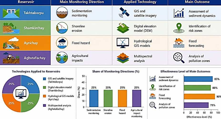
Figure. Application directions of GIS and digital monitoring technologies in selected reservoirs of the Greater Caucasus region [5]
During the processing of remote sensing data, spectral indicators of the water surface were applied:
NDWI = Green NIR Green+NIR here, NDWI - is the water index; Green - is the green spectral band; and NIR - is the nearinfrared spectral band. Through this index, water surface boundaries, turbidity levels, and hydrological changes can be identified [11].
The application of remote sensing technologies provides the following advantages: operational monitoring of large territories; acquisition of real-time data; observation of inaccessible areas; longterm analysis of hydrological changes; assessment of water quality indicators.
Digital observation systems. At the present stage, the implementation of automated digital observation systems in reservoirs plays an important role in ensuring hydraulic safety
. Through these systems, water level, pressure, filtration, temperature, and meteorological indicators are monitored continuously. Comparative analyses have shown that the application of digital sensor systems significantly enhances early warning capabilities for extreme hydrological events .
In particular, the establishment of automatic hydrological stations is of major importance for the operational monitoring of flood events formed in the rivers of the Greater Caucasus. The functional model of digital observation systems was generalized as follows:
M=f(W,T,P,S) (12)
here, M – is monitoring efficiency; W – is water level indicators; T – is temperature indicators; P – is precipitation data; and S – is the accuracy of sensor systems. According to the research findings, the implementation of digital observation systems makes a significant contribution to the operational assessment of the sanitary and technical condition of reservoirs and to risk reduction . The conducted studies revealed that the application of GIS, remote sensing, and digital observation systems in irrigation-purpose reservoirs of Azerbaijan significantly increases the efficiency of monitoring and management processes. Particularly in reservoirs located within the Greater Caucasus region, these technologies enable the оперативе identification of sedimentation, erosion, flood hazards, and water quality problems. The implementation of modern digital management systems necessitates the future development of the following directions: establishment of integrated hydrological databases; expansion of satellite-based monitoring systems; application of artificial intelligence-based hydrological forecasting models; increase in the number of automatic hydrological observation stations; development of digital risk management systems.
Directions for optimization of management systems. Ensuring the safe and efficient operation of irrigation-purpose reservoirs in Azerbaijan under modern conditions necessitates the optimization of management systems. Conducted studies indicate that the intensity of hydrological variability, sedimentation, shoreline erosion, and technical deterioration processes in reservoirs located within the Greater Caucasus region requires the modernization of management mechanisms [13].
At the present stage, the optimization of management systems is shaped according to the following principal directions: implementation of automated control systems; execution of preventive technical measures; development of sustainable operation approaches.
Automated control systems. Comparative analyses have demonstrated that automated management systems play an important role in ensuring the hydraulic safety of reservoirs .
Through digital sensors and SCADA (Supervisory Control and Data Acquisition) type control systems, indicators such as water level, pressure, filtration, temperature, and discharge are monitored in real time . It was determined that the implementation of digital monitoring elements in the Takhtakorpu and Shamkir reservoirs increased the capabilities for operational management [2].
The effectiveness of automated management was evaluated based on the following functional model:
A = f(S,D,T) (13)
here, A – is management efficiency; S – represents sensor data; D – is the operational processing of information; and T – is the level of technical control.
Preventive technical measures. According to the research findings, the timely implementation of preventive technical measures makes it possible to extend the operational lifetime of hydraulic structures and reduce accident risks [13].
The principal directions of preventive measures are as follows: removal of sediment and deposits; inspection of drainage systems; geodetic monitoring of dam bodies; filtration and leakage control; diagnostics of hydraulic equipment. Particularly in the rivers of the Greater Caucasus, periodic monitoring of sedimentation processes is considered essential due to the high intensity of sediment transport [3].
Sustainable operation approaches. According to modern scientific approaches, the sustainable operation of reservoirs should be implemented on the basis of integrated management principles . This approach envisages the comprehensive assessment of hydrological, ecological, and technical factors. Conducted studies have shown that the implementation of sustainable operation systems under climate change conditions increases the efficiency of water resources management .
Table 7
PRIORITY PREVENTIVE MEASURES IN SELECTED RESERVOIRS [3]
|
Reservoir |
Main risk |
Preventive measure |
Expected result |
|
Takhtakorpu |
Sedimentation |
Removal of bottom sediments |
Increase in useful storage capacity |
|
Shamkir |
Shoreline erosion |
Protective reinforcement measures |
Reduction of deformation |
|
Ayrichay |
Flood hazard |
Channel regulation measures |
Reduction of risk level |
|
Aghstafachay |
Pollution |
Sanitary monitoring |
Improvement of water quality |
In particular, adaptive management approaches are regarded as a priority for reservoirs located within the Greater Caucasus region. The level of sustainability was assessed according to the following model:
D=f(H,E,M) (14)
here, D is the sustainability level; H is hydrological safety; E is ecological stability; and M is monitoring quality. According to the research findings, sustainable management approaches are of significant importance for increasing the technical safety of reservoirs, preserving water quality, and improving the reliability of irrigation systems. The scientific analyses demonstrated that the optimization of management systems in Azerbaijan’s irrigation reservoirs is closely associated with the implementation of modern digital control systems, the strengthening of preventive technical measures, and the development of sustainable operation principles. Particularly in reservoirs located within the Greater Caucasus region, the application of these approaches is of strategic importance for reducing hydrological risks and enhancing sanitary and technical safety.
Conclusion
As a result of the research conducted, it was determined that the current sanitary and technical condition of Azerbaijan’s irrigation reservoirs is shaped by the combined influence of hydrological variability, intensive sedimentation, technogenic deterioration, and climate change. In particular, reservoirs located within the Greater Caucasus region are characterized by higher intensities of flood processes, erosion, and sediment transport, resulting in more pronounced hydraulic safety problems. The principal scientific findings identified during the study are as follows: it was determined that the main factor causing the reduction of the useful storage capacity of reservoirs is the increase in silt and bottom sediment accumulation; hydrological risks were found to be characterized by higher variability within the river basins of the Greater Caucasus region; it was revealed that the impacts of climate change have increased the instability of water resources and evaporation losses; the application of modern GIS, remote sensing, and digital monitoring technologies was substantiated as highly effective for the operational assessment of risks; automated management systems and preventive technical measures were determined to play an important role in the safe operation of hydraulic structures.
The following principal problems were identified during the research: intensive sedimentation and accumulation of deposits in reservoirs; shoreline erosion and channel deformations; intensification of technical deterioration processes in certain hydraulic structures; insufficient development of monitoring systems; increasing negative impacts of climate change on water resources. Based on the analyses conducted, the following practical recommendations were proposed: broad implementation of automated digital monitoring systems in reservoirs; organization of continuous hydrological observations based on GIS and satellite data; strengthening of preventive engineering measures against sedimentation and erosion processes; provision of modern diagnostic and safety systems for hydraulic structures; development of adaptive management strategies in accordance with climate change conditions; improvement of integrated water resources management mechanisms. In general, the research conducted demonstrates that the implementation of modern monitoring technologies, the development of sustainable management approaches, and the strengthening of preventive technical measures are of strategic importance for enhancing the sanitary and technical safety and long-term operational efficiency of Azerbaijan’s irrigation reservoirs.
