
Contributions of the Domuztepe Excavations to Mesopotamian Prehistory
Journal: Brief Communications of the Institute of Archaeology @ksia-iaran
Article in issue: 283, 2026.
Free access
Domuztepe, located in Türkiye’s Eastern Mediterranean region, is situated at the intersection of the Taurus and Amanos Mountains in an area that was once semi-swampy. Excavations at Domuztepe were conducted as a joint American-British project between 1995 and 2012, and since the 2013 excavation season, have been carried out by a Turkish team from Hacettepe University in Ankara. A mound settlement, Domuztepe, covers an area of approximately 30 hectares and has two peaks, one in the north and one in the south. These peaks are approximately 12 meters above the plain. The highest point of Domuztepe is 540 meters above sea level, and it is now located within an area where intensive agricultural activities take place. In addition, medieval ceramic fragments are visible on the surface. A Roman garrison was identified in the northern peak during the work of the previous excavation team. Furthermore, both the former and current excavation teams have shown that the settlement exhibits Halaf characteristics, which hold a special place in the prehistory of Upper Mesopotamia. The surface of this pottery is mostly covered with painted decoration. In addition to traditional Halafian motifs, those unique to Domuztepe are also noteworthy. On the other hand, alongside Halafian pottery, different types of Dark Faced Ware, common in the Late Neolithic Period of Syro-Cilicia, are also found in the excavations. Findings that appear characteristic of the eastern and western regions of Upper Mesopotamia are present in the same context at Domuztepe. In addition, the presence of some pottery that gives a blended appearance of elements from both regions indicates that Domuztepe held a special position in the Late Neolithic Period of Mesopotamia.
Short address: https://sciup.org/143186100
IDS: 143186100 | DOI: 10.25681/IARAS.0130-2620.283.136-154
Вклад раскопок поселения Домузтепе в изучение древнейшей истории Месопотамии
Поселение Домузтепе в восточной части Средиземноморского региона Турции расположено на стыке хребта Тавра и гор Амана на некогда полузаболоченной территории. Археологические раскопки Домузтепе проводились в рамках совместного американо-британского проекта в период с 1995 по 2012 г.; с 2013 г. раскопки проводятся турецкими археологами из Университета Хаджеттепе в Анкаре. Площадь поселения Домузтепе, расположенного на небольшом холме, составляет около 30 га, холм имеет две вершины – одну в северной части холма и одну в южной. Вершины возвышаются над долиной примерно на 12 метров. Самая высокая точка Домузтепе находится на высоте 540 м над уровнем моря, в настоящий момент это зона интенсивного земледелия. На поверхности встречаются фрагменты средневековой керамики. На северной вершине предыдущим отрядом археологов был выявлен римский военный пост. Находки, обнаруженные первой и последующими экспедициями, позволили отнести памятник к халафской культуре, которая занимает особое место в древнейшей истории Северной Месопотамии. Керамика этой культуры украшена росписью. Помимо традиционных халафских мотивов стоит отметить ряд изображений, которые встречены только в Домузтепе. Помимо халафской керамики во время раскопок была найдена темнолощеная керамика различных типов, распространенная в Сиро-Киликийском регионе в позднем неолите. Находки, характерные для восточных и западных регионов Северной Месопотамии, встречаются в Домузтепе в общем контексте. Кроме того, присутствие керамики с элементами, типичными для обоих регионов, свидетельствует об особом месте Домузтепе в Месопотамии в период позднего неолита.
Text of the scientific article Contributions of the Domuztepe Excavations to Mesopotamian Prehistory
Domuztepe is located in a plain in the Eastern Mediterranean Region of Tür-kiye, within the boundaries of the modern Kahramanmaraş province and bordering the modern Gaziantep and Hatay provinces on Türkiye’s border with Syria (Fig. 1). Kahramanmaraş is situated at the intersection of the Taurus and Amanos Mountains,
Fig. 1. Map showing the location of Domuztepe (©Domuztepe’s archive)
surrounded by mountain ranges reaching 2000–2500 m in altitude in its northern and western sections. The southern part of the province consists of mountains with elevations of 900–1000 m and lengths of 20–25 km, and plains with an average elevation of 500–600 m. The Türkoğlu Plain, located west of and immediately to the east of the Amanos Mountains, was a lakebed known as Gavur Gölü until the mid-20th century and was an extension of Lake Amik (Amuq) to the south. Both lakes were drained by the state starting in the mid-20th to create agricultural land. Today, during the rainy winter months, these lakes can briefly return to their former state.
Domuztepe is located on the western edge of the Narlı Plain, east of Tut Dağı, which is about 900 m high and situated approximately 10 km east of Gavur Gölü. The literature documents that the plain where the mound is located was a semi-swampy area, even severely wet during the heavy winter months, before the state drained it through the construction of canals in the late 1950s.
Domuztepe stretches north-south across the plain, measuring 600 × 450 × 12 m. However, significant damage has been observed at the foot of the mound due to years of agricultural activities. Recent measurements using digital instruments indicate that the mound covers 30 hectares. This mound, of unusual size for a Late Neolithic settlement, is located 20 km north of Sakçagözü-Coba Höyük, a reference excavation site in ancient Near Eastern archaeology. There are no significant geographical obstacles to communication between the two settlements. Indeed, the excavations indicate that the two settlements were in contact during the Late Neolithic and even the Early Chalcolithic (Ubaid) periods.
History of Research and Excavation
Although archaeological studies in the Kahramanmaraş province date back to the early 20th century, Domuztepe did not attract much attention from research teams in the region until 1993. Undoubtedly, the main reason is that most research has focused on Hittite reliefs. Publications by the British researcher J. Garstang on his 1908 research in and around Sakçagözü-Coba Höyük make no mention of Domuztepe ( Garstang , 1908). Similarly, the German H. H. von der Osten, who undertook a comprehensive archaeological expedition that included Kahramanmaraş in 1929 and published his findings in a book, mentions the mounds and archaeological remains in the vicinity of Domuztepe but provides no information about Domuztepe itself ( Osten von der , 1929). The fact that Domuztepe was located in a semi-swampy area at that time and did not have a prominent elevation visible to the naked eye from the plain may also have contributed to this.
Domuztepe first attracted the attention of the archaeological world through a comprehensive survey of the mounds in Kahramanmaraş conducted by an American-British research group in 1993 ( Carter , 1995; Campbell et al. , 1999). Its size and the archaeological material found there immediately caught the research team’s attention. From the very first research season, some members of the team took it under their special care. While the survey team continued their investigations in the area, some members focused solely on Domuztepe for two years, eventually planning to excavate there.
E. Carter, the director of the survey team from the University of California, applied to the Turkish authorities for permission to excavate, and the first excavations at Domuztepe began in 1995 as a joint project with the Kahramanmaraş Museum Directorate. A year later, with official permission from the Ministry of Culture of the Republic of Turkiye, the Domuztepe excavations officially began as an American-British joint project under Carter’s leadership. After her retirement in 2006, S. Campbell from the University of Manchester, who had been a member of the excavation team from the beginning, took over the leadership of the excavations in 2008, and the work continued as an Anglo-American project.
The third phase of excavations at Domuztepe began in 2013 when S. Campbell voluntarily handed over the directorship of the excavations to the author of these lines in 2012. The excavations have been carried out by a team from Hacettepe University in Ankara since 20131.
New Excavations
Among the factors that led to the previous excavation team’s departure from Domuztepe was the significant role of new, strict bureaucratic rules implemented by the Ministry of Culture of the Republic of Türkiye regarding excavations nationwide from the early 2000s onwards. Therefore, the Turkish excavation team prioritized resolving these issues and did not begin fieldwork in the first season. Undoubtedly, the most important of these problems was that the entire area covered by the mound was privately owned land and used for agricultural activities. While the former team continued their work by uncovering a large area on the southern and northern elevations of the mound, they also conducted small exploratory excavations in different parts of the mound. At the end of the season, all of these exploratory excavations were again covered with waste soil and returned to the landowners. Therefore, the previous team had been conducting excavations continuously since 1995 in an area of approximately 2000 sq. m on the southern peaks of the mound, which they named Operation I 2.
Until the land expropriation process was completed, the Turkish excavation team began fieldwork in 2014 in Operation I , in a 10 x 15 m trench in the previously unexcavated northeast corner, and carried out both deepening and widening excavations there in the following years.
The new team designated the excavated area as ‘Area 1’, located northeast of Operation I and starting directly from the mound’s surface soil. Excavations in this area, which continued until 2019, reached 400 sq. m and an average depth of 1.5 m. The main reason for the new team starting excavations in this area was both to address the expropriation issue and to uncover previously unexcavated sections surrounding areas identified in the previous team’s reports, such as the ‘Death Pit’, ‘Red Terrace’, and ‘Ditch’. Understanding this ‘ritual’ area, which has attracted considerable interest in the archaeological world, in all its aspects, was the initial main goal for the new team.
During the excavations conducted by the new team between 2014 and 2019, the sections they called ‘Red Terrace’ and ‘Ditch’ were fully uncovered. However, although they reached the same level in the northeast corner of the section defined as the ‘Death Pit’, it was not possible to excavate there. These studies revealed that although the previous team initially started work in a 2000 sq. m area, in subsequent seasons they had deepened into narrow, test-like areas of varying sizes within this area, and some of these were covered with plastic sheeting and then re-covered with excavated soil at the end of the excavation season. However, since the new excavation team adopted a horizontal excavation strategy at the same level rather than a test-like method in narrow areas, they constantly encountered sections that the previous team had excavated and re-covered. This created serious problems with documentation and understanding the context. In the 400 sq. m area excavated in this area, the existence of five building layers was identified (Fig. 2). On the other hand, excavations in this area have revealed that the section the previous team called the ‘Red Terrace’ is actually an adobe basement beneath buildings with preserved stone foundations, and
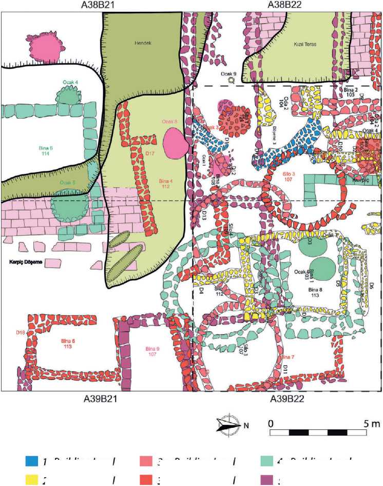
Fig. 2. Architectural plan of ‘Area 1’ (©Domuztepe’s archive)
1. Building Level
2. Building Level
За. Building Level
3b. Building Level
4. Building Level
5. Building Level not a separate section. Similarly, the section uncovered by the previous team through limited excavation and described as the ‘Ditch’ is approximately 20 m long and was identified as a street between the buildings.
Due to COVID-19, no fieldwork was conducted at Domuztepe in 2020; only documentation work for publication was carried out at the excavation house. During this period, once the issue of the first-stage expropriation was resolved, excavations in Operation I were terminated, and work commenced in a new section 20 m west of this area from the 2021 season onwards (Fig. 3).
This new excavation area has been named ‘Area 2’. In this area, as with the entire mound, the archaeological fill has been reached just below the surface soil because the mound has lost much of its original elevation due to years of agricultural activity. Excavations in four adjacent trenches3, each measuring 10 × 10 m, have revealed the stone foundations of buildings just below the surface. Two circular structures are particularly noteworthy. These structures are 2.5–3 m in diameter and are approximately 5 m apart. Their perimeters are constructed of large stones, and their bases are covered with stones of varying sizes, mostly flat. No signs of craft are found on either the foundation stones or the stones covering the bases; they appear to have been added to the architecture in their raw form using mud mortar (Fig. 4). Damage, likely caused by agricultural machinery, is immediately apparent due to their proximity to the existing mound surface. Similarly, no archaeological finds have been recovered from the bases of these structures. However, pottery fragments found in the deposit soil exhibit characteristics of the ‘Halaf-Ubaid Transition’ (HUT) phase4.
These two circular structures sit directly on top of a rectangular, two-room stonebased building without any hiatus . Thus, it has been clearly determined that the circular structures forming the 1st Building Layer and the rectangular building discovered immediately below them belong to the 2nd Building Layer. Approximately 3 m south of these structures, stone foundations of a building resembling a ‘keyhole’ running east-west have been found. The function of these structures, which were discovered in the 1930s at the famous Halafian settlement of Tell Arpachiyah and named ‘Tholos’ due to their resemblance to Mycenaean tombs, and whose existence has been confirmed in many Halafian excavations in the Near East, remains a mystery. Soil analysis using flotation techniques was performed on the building, but no plant remains were found. Therefore, it is currently not possible to say that the Domuztepe example was used as a silo for storage purposes.
Preliminary information about flint and obsidian chipped stone tools unearthed during excavations in this area in 2022 and 2023 has recently been announced to the scientific community ( Cetin Demir , 2026). Obsidian constitutes 10% of Domuztepe’s chipped stone industry, compared to flint. While there are abundant flint deposits around the settlement, especially in Tut Dagi, the nearest obsidian deposits are located in Central Anatolia (Hasan Dağ, Melendiz deposits) north of the Taurus Mountains and in Bingöl and beyond, in the Caucasus, east
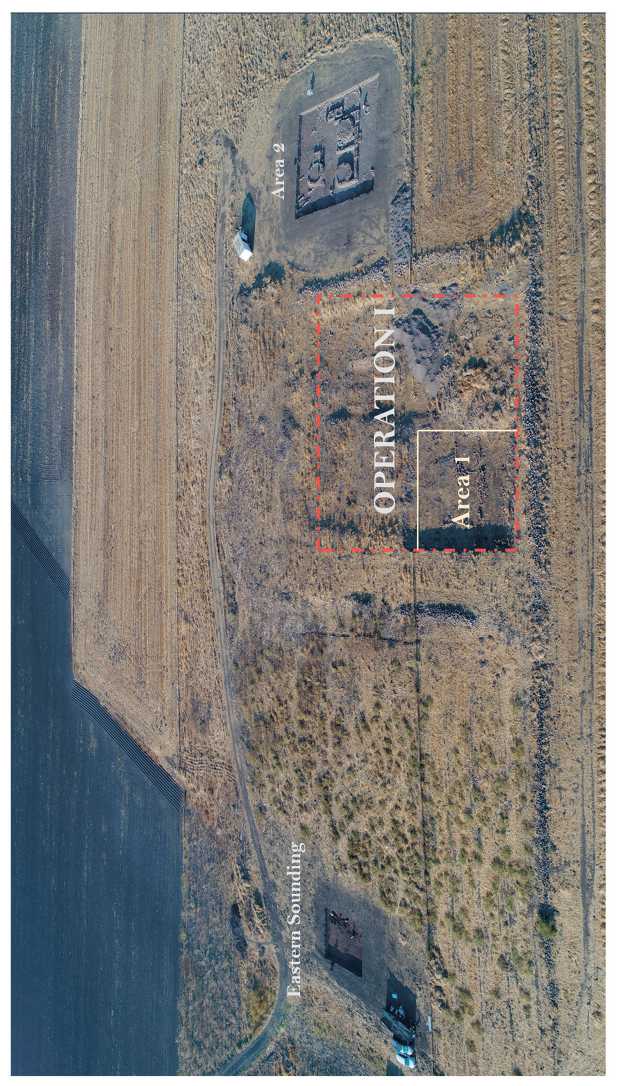
Fig. 3. The southern peak of Domuztepe, where excavations are being carried out (©Domuztepe’s archive)
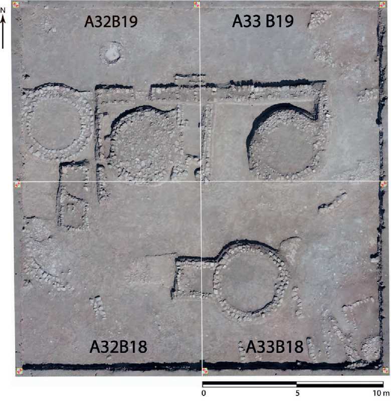
Fig. 4. Drone footage of ‘Area 2’ (©Domuztepe’s archive)
of the Taurus Mountains. The previous excavation team conducted an obsidian source analysis and reported that it originated mainly from Eastern Anatolia and the Caucasus ( Healey , Campbell , 2009)5.
During the 2024 and 2025 excavations at Domuztepe, as the excavations deepened, relatively better-preserved architectural remains were found beneath the first two upper building layers. One of these, designated Silo 3 , is 3 m in diameter and has a wall with fairly regularly arranged stones on both its inner and outer perimeters.
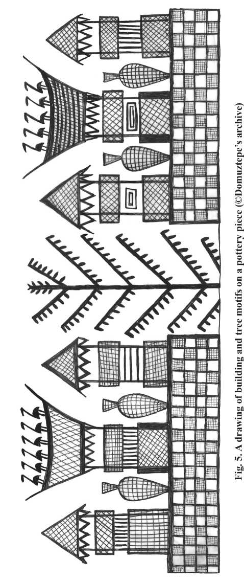
Traces of wood are visible between these two perimeters. The Late Neolithic buildings at Domuztepe share some common characteristics. These characteristics have been identified in excavations conducted by both the former and new excavation teams. Almost all buildings, whether rectangular or circular in plan, have stone foundations. In addition, pisé -built buildings are rare. The stones used in the foundations were brought from nearby Tut Dağı and used in their raw state, without processing. Another characteristic is the absence of a second row of stones in these foundations. That is, the stones forming the foundations are placed side by side in two or more rows, not stacked on top of each other. Traces of wood and reeds (carbonized) observed between the stone foundations provide insight into the upper part of the wall. The best evidence of how these buildings looked in three dimensions is found in the motifs painted on pottery fragments (Fig. 5).
Pottery
The pottery unearthed by the new excavation team has been completely re-described using new terminology for clay groups and typological classifications6. Pottery analyses are continuing based on the clay groups and typological classifications established in the 2014 excavation season ( Tekin , 2016).
The pottery from Domuztepe is like a Western representative of the Halafian examples in the traditional terminology of Upper Mesopotamia. Similarities in the clay composition and painted decorations prove that Domuztepe belongs to the same horizon as its contemporaries along the Euphrates and Tigris rivers. Furthermore, the abundance and variety of ‘narrative’ scenes place the examples from this settlement in a privileged position.
Halaf, which holds a special place in the prehistory of Mesopotamia, stands apart from examples such as Hassuna, Samarra, and Ubaid, particularly with its unique pottery. Although these ceramics share similar clay structures and geometric decorations, they can be easily distinguished with the naked eye when placed side by side. In particular, the Halafian pottery forms and the finely crafted painted decorations on the surface set it apart in terms of quality.
The Halafian pottery from Domuztepe exhibits a rich, meticulously decorated array of paints, unparalleled among contemporary settlements. The surfaces of medium and large-sized vessels feature a wealth of narrative scenes. Among these motifs, buildings and trees consistently hold a special place ( Tekin , 2020). Another striking feature is the depiction of trees individually. To date, no multiple trees side-by-side have been found. The trees, with their clearly defined branches and leaves, appear to represent multiple species. Although the trunks and leaves of these trees are stylized, it is possible to speculate on their species (Fig. 6). It would not be wrong to say that the trees depicted on the ceramics are pine, juniper, and oak, which are still present in the vicinity of Domuztepe today.
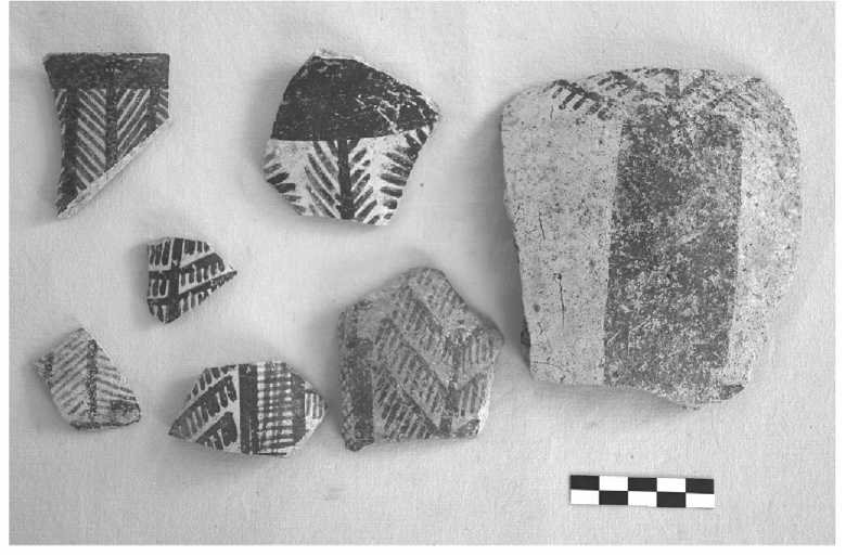
Fig. 6. Sherds with various wood motifs as painted decorations (©Domuztepe’s archive)
Another striking motif seen on the ceramics is birds. Mostly depicted perched on house roofs, in some examples, the birds are shown flying in a line ( Tekin , 2023). The birds, representing different species, are stylized, like the other motifs ( Tekin , 2021; 2024). However, there are also distinct species, such as storks, cranes, and eagles (Fig. 7). The fact that these birds are mostly migratory and are consistently depicted in narrative scenes on the ceramics must also be related to the community’s lifestyle. For the Neolithic inhabitants of Domuztepe, located in a semi-marshy area, migratory birds may have been harbingers of seasonal cycles. This is because the lakes in and around Kahramanmaraş were stopover areas for intercontinental migratory birds before they were drained. In the 1950s, experts who conducted research in the region observed that hundreds of thousands of migratory birds stayed in these wetlands for a period in spring and autumn. It is possible that a similar situation was observed by the Neolithic community, enabling them to track seasonal cycles easily. Birds, as an important indicator of time, may therefore have found a prominent place in the stories on the ceramics.
While Domuztepe pottery is rooted in the Mesopotamian tradition, it also strongly represents the Syro-Cilician tradition. The Dark Faced Ware group, commonly found in the region and even constituting as much as 90 % of the pottery assemblage in some excavations, is represented at Domuztepe with both red and grey/black slips. These vessels exhibit high-quality surface artistry and decorative techniques, including incised, impressed, and pattern-burnished. A unique feature is the presence of figurative
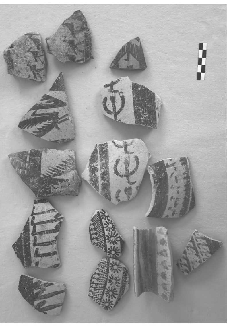
Fig. 7. Pieces of pottery with various bird motifs painted on them (©Domuztepe’s archive)
motifs, not seen in contemporary examples in the region. At Domuztepe, this decorative method is applied to bird and tree motifs (Fig. 8: a, b ). It can be said that the potters of Domuztepe blended Eastern and Western traditions, thereby creating a new decorative method. This appears to be an innovation in prehistoric Mesopotamian pottery. Although no pottery workshop or kiln has been unearthed in the excavations so far (both former and new), considering the size of the settlement, it is reasonable to assume that pottery was produced locally in such a large settlement. Moreover, the area excavated so far is less than 1 % of the entire settlement.
The frequent inclusion of human motifs in the painted decorations on the vessels is unusual in the Halafian tradition. In the narrative scenes depicted in the painted decorations, both men and women are represented. Male figures are shown singularly, sometimes with a bow and arrow or climbing a building. At the same time, women are depicted holding hands and dancing (Fig. 9). These examples provide concrete evidence that the origins of this dance form, still very popular in the Near East and known as ‘halay’, date back to the Late Neolithic period at Domuztepe. It can also be considered that this dance was not merely entertainment or celebration, but part of a ritual related to belief ( Carter, Campbell , 2008). The practice of holding hands and moving in a circle in rhythm, known as ‘zikir’ (dhikir) and still observed today, is observed across different ethnic groups and belief systems in the Near East.
On the other hand, human motifs consisting only of heads are also seen in Domuztepe ceramics. Beardless and mustache-fewer male heads are depicted side-by-side in a series as painted decorations surrounding the vessels’ bodies (Fig. 10). Although the purpose of these depictions is not fully understood, they may represent a skull cult. In the work carried out by the previous excavation team, it was determined that both male and female skulls were buried in the area called the ‘Death Pit’ as a special ritual indicator ( Campbell , 2014). The fact that only male heads are depicted in the excavations is another noteworthy point. Because among the skulls unearthed around the ‘Death Pit’, there are also female skulls.
The pottery of Domuztepe offers interesting insights not only into its rich decorative tradition but also into its technological aspects. Technological analyses7 of the samples unearthed during excavations offer equally instructive information. To date, comprehensive analyses of the technology of Domuztepe ceramics and samples from other contemporary settlements have been conducted and published ( Petrova , 2025; Petrova et al. , 2025).
Evaluation
While the existence of a Mesopotamian settlement of such magnitude as Domuz-tepe in Türkiye’s Eastern Mediterranean region might initially seem surprising, it is actually a situation that should be considered normal. Although much of the information about prehistory in Mesopotamia comes from the area between the Tigris and Euphrates rivers, particularly the Jezirah region, it should not be forgotten that the earliest information about Samarran and Halafian painted artifacts came from
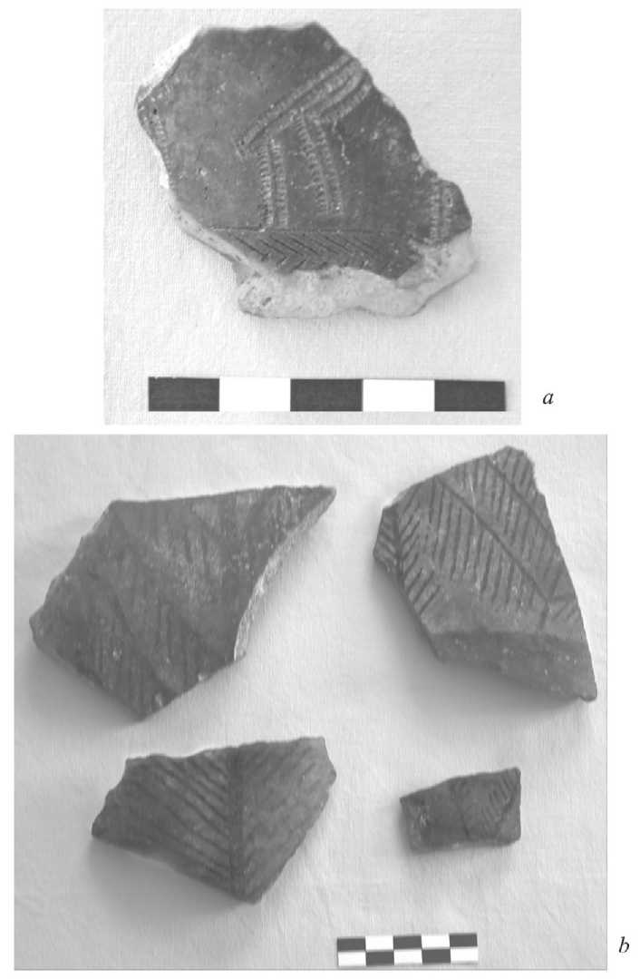
Fig. 8a. A bird motif created with printed ornamentation (©Domuztepe’s archive)
Fig. 8b. Tree motifs created using the pattern burnished technique (©Domuztepe’s archive)
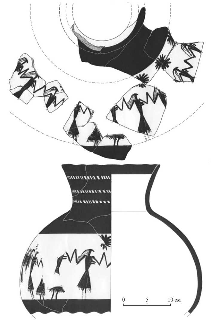
Fig. 9. The painted decorations feature motifs of women dancing (in a traditional Turkish folk dance, Halay) (after Carter, Campbell , 2008. P. 125. Fig. 7)
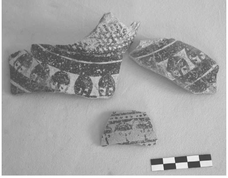
Fig. 10. Skull motifs created as painted decorations (©Domuztepe’s archive)
the Sakçagözü-Coba Höyük excavation in 1908. The excavations and their interpretations conducted in the first half of the last century regarding prehistory in Mesopotamia brought about certain perceptions. Research groups from several Western universities reached almost identical conclusions, leading to the formation of a paradigm in Mesopotamian archaeology. Researchers at the same institutions, following in their mentors’ footsteps, remained faithful to this paradigm. Undoubtedly, Soviet research, which began in the late 1960s, made a significant contribution to changing this paradigm. Subsequently, the different approaches taken by Japanese, Polish, and Czech researchers began to question the paradigm that had characterized the last century.
Since the early 1960s, excavations and research conducted within Türkiye’s borders, primarily at Çayönü and along the southern slopes of the Taurus Mountains, have added new insights into the prehistory of Mesopotamia. Particularly in the early 2000s, the construction of dams on the Euphrates and Tigris rivers in Türkiye accelerated archaeological research, yielding discoveries. The most striking of these new findings concerns the size of the settlements where Halafian pottery was found. While Halafian settlements in classical Mesopotamian lands averaged 3-5 hectares, unusually large settlements of 10-30 hectares have been identified on the southern slopes of the Taurus Mountains.
Among these, the most notable is undoubtedly Domuztepe. Although the radiocarbon dating results for the five building layers identified in the new excavations are still in the laboratory, publications by the former team indicate that the settlement was inhabited between 6800 and 5450 BCE. The information obtained by the new team regarding the reason and timing of the settlement’s abandonment is particularly valuable. Dr. Arman Tekin’s Ph.D. thesis ( Tekin , 2025a) presents important findings regarding the abandonment of the settlement and its relationship with other settlements in the vicinity ( Tekin , 2025b).
The findings from the Domuztepe excavations are also significant for understanding the ‘Halaf-Ubaid Transition’ phase of Mesopotamian prehistory, which remains a mystery. Given the scarcity of excavations covering this phase, the importance of the Domuztepe data becomes even more apparent.
The initial settlement of the site is also an important question. In 2023, a test excavation was opened on the eastern slope of the mound to begin searching for answers to this question. While the virgin soil has not yet been reached, this excavation aims to obtain detailed information about the settlement’s earliest inhabitants and, in particular, to identify the presence of Samarran sherds mentioned in the publications of the previous excavation team.
By the beginning of the 21st century, the presence of prehistoric Mesopotamian finds west of the Euphrates was explained as an ‘influence’ or ‘related,’ and it was believed that the core area had always been between the Tigris and Euphrates rivers. The Domuztepe excavations have strongly suggested that this may not be true. It seems likely that this idea will change with future excavations both at Domuztepe itself and in the surrounding area. It is also possible that we will encounter a very different Mesopotamia in the second half of the 21st century.
