
Emerging Archaeological Evidence in Iraqi Kurdistan: Reexamining the 7th – Mid 6th Millennia BCE
Journal: Brief Communications of the Institute of Archaeology @ksia-iaran
Article in issue: 283, 2026.
Free access
Recent archaeological investigations conducted in Iraqi Kurdistan have considerably expanded our understanding of the Late Neolithic period in the eastern Fertile Crescent. New surveys and excavations carried out over the past decade provide important data that challenge the traditional view of a relatively homogeneous Halaf cultural horizon across northern Mesopotamia. This contribution aims to present updated information regarding archaeological developments in Iraqi Kurdistan and to reconsider the dynamics of the Late Neolithic between the VII and the mid-VI millennia BCE.
Short address: https://sciup.org/143186098
IDS: 143186098 | DOI: 10.25681/IARAS.0130-2620.283.100-116
Новые археологические материалы в Иракском Курдистане: к вопросу о VII – начале VI тыс. до нашей эры
Последние археологические исследования в Иракском Курдистане существенно расширяют наше понимание поздненеолитического периода в восточной зоне Плодородного полумесяца. За последние десять лет в ходе новых исследований и археологических раскопок получены важные данные, которые оспаривают традиционный взгляд на халафский горизонт Северной Месопотамии как относительно однородный. Цель данной статьи состоит в актуализации информации о последних археологических исследованиях в Иракском Курдистане и пересмотре динамики позднего неолита в VII – начале VI тыс. до н. э.
Text of the scientific article Emerging Archaeological Evidence in Iraqi Kurdistan: Reexamining the 7th – Mid 6th Millennia BCE
Introduction. Halaf Cultural Variability
The Halaf cultural horizon has long been considered one of the most distinctive archaeological phenomena of the Late Neolithic in northern Mesopotamia, particularly due to its highly decorated painted pottery and wide geographical distribution. Traditionally, it has been interpreted as a relatively homogeneous cultural entity extending from northern Syria to northern Iraq. However, this view has increasingly been challenged. The present study contributes to reassessing the apparent homogeneity attributed to the Halaf cultural sphere. As early as the mid-twentieth century, A.Perkins (Perkins, 1949) identified stylistic differences between Halaf painted pottery from northern Iraq and northern Syria, based on comparisons between largely unstratified western material and the well-documented assemblages from Mallowan’s excavations at Arpachiyah (Mallowan, Rose, 1935) Mallowan’s work played a key role in shaping early interpretations of the Halaf period. His excavations at Arpachiyah in 1933 established one of the first stratified sequences and positioned the Halaf chronologically between the Hassuna/Samarra traditions and the Ubaid horizon. However, the exceptional character of the Arpachiyah assemblage, especially its finely decorated
polychrome pottery, also contributed to a normative image of the Halaf later shown to be only partially representative.
Broader perspectives emerged through the work of Robert J. Braidwood and his collaborators. Through the Iraq-Jarmo Project and research in the Zagros “Hilly flanks”, Braidwood emphasized the importance of this region for the emergence of early agricultural societies ( Braidwood, Howe , 1960; Braidwood et al ., 1983). His interdisciplinary approach demonstrated that farming developed gradually through local adaptations rather than diffusion or migration, situating the Halaf within a longer continuum of regional development.
Subsequent research reinforced the recognition of regional variability. T. Davidson ( Davidson , 1977; Davidson et al ., 1981) showed that ceramic assemblages exhibit stylistic and technological differences across northern Mesopotamia, suggesting localized traditions within a broader network. Soviet excavations at Yarim Tepe led by Munchaev and Merpert provided key stratified sequences and documented the gradual emergence of Halaf material culture after earlier Hassuna contexts ( Мунчаев, Мерперт , 1981; Merpert, Munchaev , 1987; 1993; Bader, Le Mière , 2013). This research emphasized long-term development and endogenous transformation, interpreting the Halaf as a cumulative process rather than a sudden phenomenon. Similarly, excavations by I. Hijara ( Hijara , 1997) highlighted the regional expression of Halaf culture within local settlement systems. Together, these studies redefined the Halaf as a phenomenon characterized by significant regional diversity.
More recent research has further developed this perspective ( Campbell 1992a; 1992b; Matthews , 2000; Spataro, Fletcher , 2010; Nieuwenhuyse et al. , 2013; Nieuwenhuyse , 2016), interpreting the Halaf as an interaction sphere defined by shared practices and marked local variability. Sh. Amirov ( Амиров , 1994) emphasized regional developmental sequence based on the morphology painted pottery evolution.
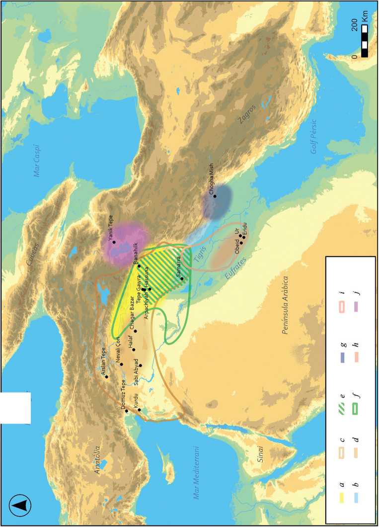
Campbell has also been central in reassessing the origins and dynamics of the Halaf. He argued that its spread reflects complex local developments rather than a single expansion event, with material culture emerging gradually from earlier traditions. Similarities in pottery and other materials are best explained through interaction networks and exchange rather than cultural uniformity. The circulation of obsidian and ceramics points to well-established long-distance connections. (Fig. 1). His reinterpretation of the Arpachiyah “Burnt House” further suggests the presence of specialized activities and emerging social differentiation ( Campbell , 2000). The concentration of high-quality pottery and administrative artefacts indicates forms of resource control and early socio-political organization, positioning Arpachiyah as a nodal site within broader interaction networks.
Studies on the Halaf-Ubaid transition ( Breniquet , 1996; Gut , 1995; Amirov , 2018) have similarly emphasized gradual transformation rather than abrupt change. Breni-quet’s analysis of ceramic production highlights shifts in technology and organization, reflecting broader economic and social restructuring. Transitional assemblages demonstrate overlap and regional variability, supporting a processual interpretation of cultural change.
Recent advances in terminology, including the concepts of Proto-Halaf ( Cruells, Nieuwenhuyse , 2004) and the Halaf–Ubaid Transitional phase ( Campbell , 2007),
Mar Negre
have further refined the understanding of these processes. At the same time, extensive excavations in Syria, at sites such as Tell Sabi Abyad, Tell Halula, Chagar Bazar, and Tell Halaf, have provided new stratigraphic and architectural data that refine the chronology and variability of the Halaf horizon ( Akkermans et al. , 2013; Nieuwenhuyse , 2018; Molist et al. , 2013; Cruells et al ., 2013; Becker , 2015). (Tab. 1).
In this context, revisiting archaeological evidence from northern Mesopotamia remains essential for understanding the emergence and development of Late Neolithic societies. While research in northern Syria has long dominated the field, the eastern Fertile Crescent is now emerging as a key area for investigating these processes.
Archaeological Research in Iraqi Kurdistan
In contrast to the well-established archaeological sequences of northern Syria and the western Fertile Crescent, the eastern Fertile Crescent and particularly Iraqi Kurdistan, has only recently emerged as a major focus for investigating the Late Neolithic transition. As a result, the eastern regions of Upper Mesopotamia were long underrepresented in broader models of Neolithic development. This situation has changed significantly over the past decade. Since 2012, a series of large-scale regional survey projects have been undertaken across Iraqi Kurdistan, greatly expanding the available dataset for the seventh and sixth millennia BCE. Major initiatives, including the Land of Nineveh Archaeological Project (LoNAP), the Erbil Plain Archaeological Survey (EPAS), the Upper Greater Zab Archaeological Reconnaissance (UGZAR), Shahrizor survey project and the Eastern Habur Archaeological Survey (EHAS), have adopted systematic and comparable methodologies, integrating intensive field survey, ceramic typology, and landscape analysis. Together, these projects have begun to provide a more coherent and regionally integrated picture of settlement dynamics and cultural variability during the Late Neolithic (Fig. 2).
Among these, the LoNAP project has made a particularly significant contribution to reconstructing prehistoric settlement patterns in northern Iraq ( Iamoni , 2014; Morandi Bonacossi, Iamoni , 2015; Gavagnin et al. , 2016). Survey results indicate a substantial diachronic increase in the number of sites. According to E. Regattieri ( Regattieri et al. , 2023), settlement numbers rise from approximately five sites during the Initial Pottery Neolithic (IPN) to around twenty in the Early Pottery Neolithic (EPN), reaching roughly thirty-five sites during the Halaf period. This trajectory suggests not only demographic growth but also an increasing structuring of the landscape, with the consolidation of settlement networks and intensified exploitation of agricultural and pastoral resources.
Fig. 1 (p. 102–103). Map of the study area showing the location of Banahilk and other Late Neolithic sites. Author: B. Soriano, GRAMPO, UAB a – Hassuna (6600–6000NE); b – Choga Mami transitional (5900–5600ANE); c – Halaf (5900–5300ANE); d – Proto-Halaf (6100ANE); e – Samarra antic (6200AME); f – Samarra recent (5700ANE); g – Susiana (6600–5700ANE); h – Obeid 0-1 (6400–5600ANE); i – Obeid 2 (5600–5300ANE); j – Ourmia: Fase Hajji Firuz (6500–6000ANE) and Dalma (5900–4900ANE)
Table 1. Summary table of the chronological framework (based on: Kolinska et al. , 2024)
|
ад о ’о g о Н |
2 2 “ ^ ^ з Й ^ ад Л "О -1 2 Ф ад |
о ад 2 3 |
ад 04 04 2 <3 б ей ей к |
ад ей Й 2 й 29 ей GO О 2 К о о 2 |
о А ад ей ад ад 04 й ^ ^ ^ У § § £ Ь « § g > к д к |
о ад ^ 53 /—ч S й 2 Л Л «За т П ьн 2 2 ад — Й ^" к д к |
о ад 2; 2 ^ ад ^ ^ 04 g ад = ад §0^ Е 5 — Й ^" к д к |
'о4 ад . ей — й ОО —( 04 2 ,—1 ОО г й ез ад Н й- 11 ел К Рн |
|
о 2 §* и л i |
2 й |
° НН 2 ео К ей S3 |
< ей ей N О S |
m ей ей О S |
2 2 2 2 Рн у ^ Е S о И £ |
|||
|
й ей GO ей 03 д |
2 о z о 2? 2 .^ й 2 Й ей 2 в |
о 2 ’о z о ,__, о w л JS И О |
ей ей В 2 и i |
> ей 2 2 В й н |
2 К И |
2 К о 2 ■d S |
2 К о |
■^ 2 2 2 2 Рн у ^ Е S о И £ |
|
ей £ GO И г о4 г |
СЙ ей и 2 ^ £^ |
1 ей к О О i |
g и Й К 8 .2 И |
g Й , g и и £ |
2 2 К и |
2 2 К о 2 ■d S |
2 К о |
---. 2 2 Рн U ^ 3 S О И £ |
|
о ад 55 |
3 |
ад 3 |
3 |
3 |
РА "ей и К |
о S к |
2 К о |
адад t 3S С Й 2 ей о 2 к к z 5 |
|
£ и S « |
о о чо о о о |
о о чо о о 40 |
о о о 40 о о 40 |
о о 04 ш о о о 40 |
о о ю о о 04 ш |
О о ш ш о о ш |
о о ш о о ш ш |
о о ш о ел |
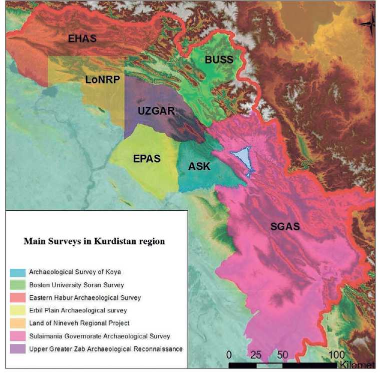
Fig. 2. Main surveys developed in the region
ASK – Archaeological survey of Konya; BUSS – Boston University Soran Survey; EHAS – Eastern Habur Archaeological survey; EPAS – Erbil Plain Achaeological Survey; LoNRP – Land of Nineveh Regional Project; SGAS – Sulaimania Governorate Archaeological Survey; UGZAR – Upper Greater Zab Archaeological Reconnaissance
Complementary data are provided by the Erbil Plain Archaeological Survey (EPAS), conducted between 2012 and 2020 (Ur et al., 2021), which offers a longterm perspective on settlement organization in an alluvial environment. The project documented at least twenty-six Hassuna-period sites distributed across the Gwer, Shamamok, and Qushtapa districts. These settlements are generally small, with a median size of one to two hectares, although occasional larger sites suggest emerging variability in site hierarchy. Their uneven spatial distribution, particularly the concentration in the Shamamok area along the upper tributaries of the Kurdara Chai, highlights the importance of hydrological systems and local environmental conditions in structuring settlement patterns. At the same time, the absence of a fully synthesized regional distribution map continues to limit broader spatial analyses.
The identification of Middle-Late Halaf settlements presents additional methodological challenges. Open-air sites of this period are often difficult to detect in survey contexts due to their small size, low relief, and dispersed surface materials. This issue is particularly pronounced in the eastern Tigris region and the inter-Zab plains, where geomorphological processes further reduce site visibility. As a result, current datasets likely underestimate the extent and variability of Late Halaf settlement systems. Nevertheless, evidence from eastern regions such as Shahrizor plain ( Altaweel et al. , 2012; Odaka et al. , 2019) suggests that such sites may have been more widespread and regularly occupied than previously assumed, pointing to a more flexible and possibly seasonal pattern of habitation.
A key case study is the site of Qalinj Agha, located in the Erbil plain, which provides important evidence for Halaf occupation in northern Iraq. Excavations conducted by B. Abu Al-Soof ( Abu Al-Soof , 1966; 1969) revealed a relatively small settlement with limited architectural remains but a substantial ceramic assemblage, now housed in the Erbil Archaeological Museum. The material clearly belongs to the Halaf cultural tradition, with manufacturing techniques, clay preparation, pigments, and decorative schemes closely paralleling those documented at major sites such as Arpachiyah and Yarim Tepe. The assemblage is characterized by a high degree of technical refinement and includes finely painted pottery decorated with geometric motifs such as triangles, dots, intersecting lines, and banded compositions.
At the same time, these stylistic features demonstrate clear affinities with assemblages from the Euphrates and Khabur valleys, suggesting the existence of extensive interaction networks across northern Mesopotamia during the Late Neolithic. The circulation of ceramic styles and technological practices, alongside the distribution of materials such as obsidian from eastern Anatolian sources, points to well-established systems of exchange and communication linking communities across a wide geographical area.
Ongoing research projects, particularly the UGZAR project, continue to provide new data on Pre-Halaf occupation in the Zagros region ( Kolinska et al. , 2024). Although many of these results are still forthcoming, they are expected to significantly refine current models of settlement organization, cultural development, and regional interaction in the eastern Fertile Crescent during the seventh and sixth millennia BCE ( Bach Gómez , 2024). Taken together, these recent investigations demonstrate that Iraqi Kurdistan played a central role in the development of Late Neolithic societies and must be fully integrated into broader interpretative frameworks of Mesopotamian prehistory.
Several key sites have been instrumental in shaping this new perspective. Excavations at Tell Begum (Gird-i Begum) have revealed well-stratified sequences including Halaf levels underlying later Chalcolithic occupations, highlighting both longterm settlement continuity and regional developmental trajectories ( Nieuwenhuyse et al. , 2016; Nieuwenhuyse , 2018). At Helawa, investigations led by L. Peyronel have uncovered well-preserved Late Halaf levels associated with domestic architecture, providing valuable insights into household organization, craft activities, and everyday practices ( Peyronel, Vacca , 2020). Further evidence comes from sites such as
Logardan and Shimshara, where ongoing research has contributed to reconstructing broader settlement histories and refining regional chronological frameworks for the Late Neolithic and Chalcolithic periods ( Vallet et al. , 2019; Matthews et al. , 2020).
In the Shahrizor Plain, sites such as Shakar Tepe have yielded important new data for defining the eastern extent of the Halaf cultural sphere. Recent excavations have documented well-stratified Late Halaf levels dated to the mid-sixth millennium BCE, alongside later Chalcolithic occupations, providing a more continuous regional sequence ( Odaka et al. , 2019; 2025). The material culture from these sites, particularly ceramic assemblages, shows clear affinities with classical Halaf traditions while also displaying distinctive local traits, such as specific tempering practices and decorative conventions, suggesting the existence of an eastern variant of the Halaf ( Nieuwen-huyse , 2018; Odaka et al. , 2019). This combination of shared and regionally specific characteristics points to locally embedded trajectories of development operating within a broader network of cultural interaction across northern Mesopotamia.
Recent Research on the Late Neolithic of the Northern Zagros: The Case of Banahilk
The present study focuses on the Upper Zagros region, specifically the area between the Greater and Lesser Zab rivers, a geographically strategic corridor linking the mountainous zones of the Zagros with the Mesopotamian lowlands. Although primarily based on surveys and limited test excavations, these pioneering investigations established a foundational framework for understanding Neolithic settlement dynamics in the Zagros “hilly flanks” ( Braidwood, Howe , 1960) identifying sites such as Banahilk as key reference points for the study of early village societies.
Within this regional context, Banahilk represents an important case study for examining the Pottery Neolithic sequence in the Northern Zagros. This article aims to provide an updated synthesis of the archaeological sequence from the seventh millennium BCE to the end of the Halaf period, while also presenting new data derived from recent investigations at the site.
Banahilk is a small archaeological mound located approximately one kilometer southwest of the modern village of Dyana, in the Soran region of Iraqi Kurdistan. The site measures roughly 100 × 160 meters and reaches a maximum height of just over four meters, covering an area of approximately 1.5 hectares ( Watson , 1983). It occupies a strategic position at the intersection of two river courses connected to the Balakiyan-Rowanduz river system, overlooking fertile valleys within the Soran-Dyana plain, a natural corridor approximately 9–10 km wide and about 20 km long, enclosed by mountainous terrain. This location would have offered access to arable land, water resources, and communication routes linking the Zagros highlands with the Mesopotamian plains, making it particularly suitable for early agro-pastoral communities (Fig. 3).
The history of archaeological investigations at Banahilk reflects broader patterns of research in the region. The site was first explored in 1954 by Patty Jo Watson as part of the Iraq–Jarmo Expedition directed by Braidwood (Braidwood et al., 1983; Braidwood, Howe, 1960; Watson 1983). The work consisted of a brief sounding over approximately ten days, during which several small trenches were opened. Despite its limited scope, this early investigation suggested that Banahilk was a relatively small settlement with a short occupation during the final stages of the Halaf period.
After several decades of limited activity, renewed attention to the site began in 2014, when Michael Danti and the Rowanduz Archaeological Program carried out rescue excavations in collaboration with the Soran Directorate of Antiquities. These interventions identified well-preserved Halaf deposits beneath later disturbed layers, confirming the significance of the site within the Late Neolithic sequence of the region.
Since 2018, a new research program led by the Autonomous University of Barcelona (SAPPO–GRAMPO team), in collaboration with the Soran Directorate of Antiquities and Salahaddin University, has undertaken systematic surveys and excavations at Banahilk. These recent investigations aim to refine the stratigraphic sequence, document settlement organization, and better understand the role of the site within regional networks during the Late Neolithic. Taken together, these phases of research demonstrate the importance of Banahilk as a key site for reconstructing the development of Halaf communities in the eastern Fertile Crescent.
Excavations, Architecture, Material Culture and Chronology at Banahilk
Recent excavations at Banahilk have focused on 8 sectors located on the upper platform of the mound, providing important insights into the spatial organization and occupation of the site during the Late Halaf period ( Gómez-Bach et al. , 2019). The results reveal a structured settlement layout combining domestic architecture, outdoor activity areas, and associated material assemblages.
In Sector 1, excavations uncovered architectural remains clearly associated with domestic occupation, including stone and mud-brick walls, beaten-earth floors, and a range of storage installations such as silos and mud-built containers. These features indicate the presence of well-organized household units and suggest that this area functioned as a domestic zone dedicated to storage, food processing, and everyday activities. Complementary evidence comes from Sector 3, where excavation has identified outdoor activity areas characterized by burnt layers containing concentrations of charcoal, ash, and fragmented ceramics. These deposits likely represent zones related to food preparation, craft-related activities, or refuse disposal. The spatial differentiation between enclosed domestic structures and adjacent open-air areas points to a deliberate and structured use of space within the settlement, reflecting patterns of household organization typical of small Halaf communities.
Additional insights into domestic architecture are provided by Sector 8, where a well-preserved architectural unit corresponding to a Late Halaf domestic structure has been documented. The building is defined by rectilinear mudbrick walls preserved at foundation level, with an average thickness of approximately 40–50 cm. In several sections, particularly along the inner face of the western wall, small stones have been incorporated as reinforcement, suggesting deliberate construction techniques aimed at enhancing structural stability. The structure encloses a sub-rectangular interior space with a compacted beaten-earth floor and no clear evidence of internal partitioning, indicating that it likely functioned as a single-room domestic unit. Within the interior, a shallow circular or oval installation, possibly a pit or storage feature and
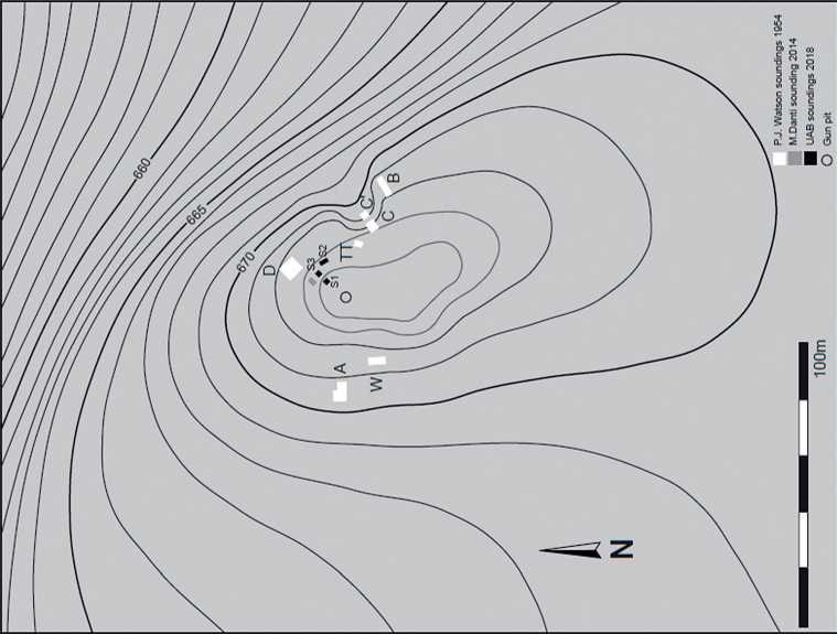
Fig. 3. Map showing the location of Banahilk and the main excavation soundings
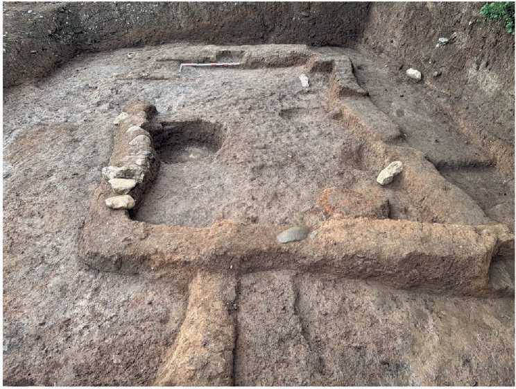
Fig. 4. Banahilk site, Sector 8: domestic unit L.36. Author: A. Bach, GRAMPO, UAB a hearth, suggests that the space was used for multiple household activities, including food preparation, storage, and small-scale craft production. The entrance is tentatively located along the southern side, where a slight discontinuity in the wall alignment and a compacted surface may indicate an access point. Immediately outside the building, leveled surfaces and activity traces point to the presence of associated outdoor working areas, reinforcing the interpretation of a domestic unit organized around both indoor and outdoor functional spaces. The presence of a rectilinear structure, rather than the more commonly cited tholos-type buildings, highlights the variability of Halaf domestic architecture and suggests the existence of flexible and locally adapted building traditions (Fig. 4).
The material culture recovered from Banahilk further supports this interpretation of a well-integrated domestic settlement. Pottery constitutes the most abundant category of finds and includes both coarse wares and fine painted ceramics characteristic of Halaf assemblages. Most vessels are small to medium-sized containers, such as bowls, dishes, jars, and cooking pots, intended for everyday domestic use. Decorative motifs are predominantly geometric, including bands, triangles, and intersecting lines, although occasional floral elements are also present. These stylistic features demonstrate strong affinities with Halaf assemblages across northern Mesopotamia, confirming the integration of Banahilk within broader cultural and stylistic networks (Fig. 5).
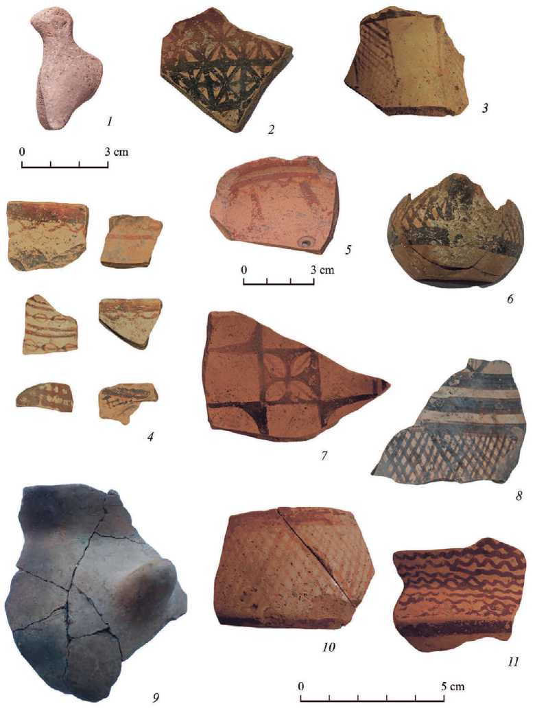
Fig. 5. Pottery assemblage from Banahilk
1 - animal figurine; 2-8 - painted ware; 9 - coarse ware; 10, 11 - painted sherds (Author: A. Bach, GRAMPO, UAB)
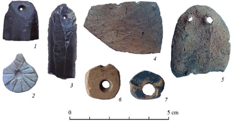
Fig. 6. Objects and other artefacts from Banahilk
1, 3 – retouched obsidian blades (Author: O. Orri, GRAMPO, UAB); 2 – pendant; 4, 5 – pottery tokens; 6, 7 – pottery beads
The presence of obsidian, likely originating from eastern Anatolian sources such as the Nemrut Dağ and Lake Van regions, provides clear evidence for long-distance exchange networks linking the Zagros piedmont with wider Near Eastern interaction systems. The faunal assemblage indicates a subsistence economy primarily based on domestic species, including sheep, goats, pigs, and cattle, consistent with established agro-pastoral practices during the Late Neolithic. Other categories of material culture include small findings lithic tools, bone implements, and faunal remains (Fig. 6).
Chronological data derived from radiocarbon analysis provide a more precise framework for the occupation of the site. Early samples obtained during Watson’s excavations suggested a date within the middle of the sixth millennium BCE. More recent radiocarbon determinations from the new excavation phases indicate a more restricted timeframe for the final occupation, approximately between 5559 and 5473 cal BCE. These results confirm that Banahilk was occupied during the later stages of the Halaf period and contribute to refining the chronological resolution of Halaf settlement in the eastern Fertile Crescent.
Conclusion
The results presented in this study contribute to a growing body of evidence that challenges the traditional view of the Halaf as a homogeneous cultural horizon across northern Mesopotamia. Instead, the data from Iraqi Kurdistan – particularly from recent surveys and excavations – support the interpretation of the Halaf as a highly variable and regionally differentiated phenomenon embedded within broader networks of interaction.
The integration of new regional datasets from projects such as LoNAP, EPAS, and UGZAR has demonstrated a significant increase in settlement density during the seventh and sixth millennia BCE, reflecting processes of demographic growth, landscape structuring, and intensified exploitation of agro-pastoral resources. At the same time, the variability observed in site size, spatial distribution, and material culture highlights the existence of diverse local trajectories within a shared cultural framework.
In this context, the evidence from key sites in Iraqi Kurdistan, such as Tell Begum, Helawa, Logardan, Shimshara, and Shakar Tepe, has been instrumental in redefining the eastern dimension of the Halaf cultural sphere. These sites reveal both strong connections with the wider Halaf tradition and the persistence of locally specific traits, supporting the identification of an eastern variant of the Halaf shaped by regional environmental conditions and cultural substrates.
The case study of Banahilk provides further insight into these dynamics. The archaeological evidence indicates that the site functioned as a small, well-organized Halaf settlement characterized by a structured spatial layout combining domestic architecture, storage facilities, and outdoor activity areas. The presence of rectilinear architecture in Sector 8, alongside more typical Halaf features, underscores the variability of building traditions and challenges overly rigid typological models based on tholos architecture.
Material culture from Banahilk, particularly the ceramic assemblage, confirms its integration within broader Halaf stylistic and technological networks, while also reflecting everyday domestic practices rather than exclusively high-status production. The presence of obsidian and other non-local materials further highlights the role of long-distance exchange systems linking the Zagros piedmont with northern Mesopotamia and eastern Anatolia.
Chronologically, radiocarbon data place the occupation of Banahilk within the later stages of the Halaf period (mid-sixth millennium BCE), contributing to the refinement of regional chronological frameworks and supporting models of gradual cultural development rather than abrupt transitions.
Taken together, these results reinforce current interpretations of the Halaf as a dynamic interaction sphere characterized by overlapping networks of exchange, technological transmission, and locally embedded practices. The eastern Fertile Crescent, and Iraqi Kurdistan in particular, emerges not as a peripheral zone, but as a key region for understanding the complexity, variability, and developmental trajectories of Late Neolithic societies.
We would like to express our sincere gratitude to the organizers for the opportunity to participate in the seminar Prehistory of Greater Mesopotamia in the Light of New Investigations, dedicated to the 90th anniversary of Nikolai O. Bader It is an honour to contribute to this initiative, which brings together new research perspectives on the prehistory of Mesopotamia and highlights the enduring scholarly legacy of Nikolai O. Bader.
