
Large Dams and Rescue Archaeology in Northern Iraq: The 5th Millennium BC (Northern Ubaid) Sequence at Tell Abu Dhahir (Eski Mosul Dam Project)
Journal: Brief Communications of the Institute of Archaeology @ksia-iaran
Article in issue: 283, 2026.
Free access
This paper sets the context for the still largely unpublished excavations by N. O. Bader at Tell Sheikh Humsī in the Eski Mosul Dam Project by looking at how that rescue project was initiated by the Government of Iraq, and against the long backdrop of earlier large dam rescue projects beginning with the High Aswan Dam in Egypt where Soviet archaeology abroad was first initiated. The preliminary Iraqi archaeological survey for the Eski Mosul Dam revealed very few prehistoric sites but more were soon discovered by the different expeditions working there from 1981 to 1987. The author worked within this project for three years, and this paper summarises some of the evidence from Tell Abu Dhahir, where he excavated in 1985/1986. This yielded the longest Ubaid sequence after Tell Sheikh Humsī and gives us a rich glimpse into changing patterns of site development and “spiral stratigraphy”, beginning with a cemetery and followed by six phases of vernacular architecture, some with their own sub-phasing.
Short address: https://sciup.org/143186102
IDS: 143186102 | DOI: 10.25681/IARAS.0130-2620.283.165-181
Большие плотины и охранно-спасательная археология в Северном Ираке: стратиграфическая последовательность слоев V тыс. до н. э. (Северный Убейд) на поселении Телль-Абу-Дахир (проект строительства Эски-Мосульской плотины)
В статье рассматривается общий контекст раскопок Н. О. Бадера на поселении Телль-Шейх-Хомси в ходе реализации Проекта строительства Эски-Мосульской плотины, результаты которых почти не представлены в публикациях. По поручению Правительства Ирака советскими археологами были проведены охранно-спасательные археологические работы с учетом уже имеющегося опыта выполнения аналогичных работ по проектам строительства больших плотин в других странах, первым из которых стал проект постройки высотной Асуанской плотины в Египте. Предварительные археологические изыскания по проекту Эски-Мосульской плотины выявили незначительное количество древних памятников, однако вскоре благодаря раскопкам, проводимым разными экспедициями в 1981–1987 гг., количество открытых памятников увеличилось. Автор статьи работал в рамках данного проекта в течение трех лет. В настоящей статье дается краткое описание результатов раскопок на поселении Телль-Абу-Дахир в 1985–1986 гг., в ходе которых была выявлена самая длинная стратиграфическая последовательность слоев убейдского периода, уступающая по своему размеру только напластованию слоев в Телль-Шейх-Хомси. Анализ последовательности позволил получить ценную информацию о характере изменений в период развития поселения и «спиральной стратиграфии» от могильника до последующих шести фаз строительства зданий с учетом местной традиции и местных материалов с делением ряда фаз на субфазы.
Text of the scientific article Large Dams and Rescue Archaeology in Northern Iraq: The 5th Millennium BC (Northern Ubaid) Sequence at Tell Abu Dhahir (Eski Mosul Dam Project)
In 1981 the Iraqi Government appealed to all foreign archaeological teams for assistance in what was the third consecutive dam rescue project in the country in a decade. This was the Eski Mosul Dam Project, then known as the Saddam Dam, and between then and 1987 some 15 organisations from 10 countries participated in the project, excavating a total of 66 sites. The author worked in the project for three years, first excavating at Tell Mohammed Arab, Babneet Village and Qara Dere in the southern part, then directing multiple trenches and soundings at the large multiperiod mound of Tell Abu Dhahir in the northern part. He published an excavation report on Tell Abu Dhahir in 2007, as well as several research papers, and is
now completing a monograph on later periods which includes a detailed review of the history of dam salvage archaeology across the Middle East over the course of the 20th and 21st centuries. In the Eski Mosul Dam Project, the teams generally worked independently and it is to my regret that I did not see our Russian colleagues then excavating the site of Tell Sheikh Humsi, although we were then only some 12 km away at Tell Mohammed Arab. However, the Polish team headed by Professor Karol Kozlowski recounts how they met up at the Polish dig-house at Nebi Yunus and showed them what they suspected were PPN flints they had collected at Nemrik while surveying for Palaeolithic sites above the river valley: ‘Nikolai said just one sentence: ‘Я всегда мечтал о такой стоянке’ [‘I have always dreamed of a site like that!’] ( Kozlowski , 2002. P. 15).
Following the high profile of the High Aswan Dam, Syria, Turkey and Iraq embarked on their own programmes of building large dams. Within Iraq, six have been constructed to date: the Dokan, Darbandikhan, Bekhme, Hamrin, Haditha and Eski Mosul, and plans for a seventh at Assur remain on the table. Almost all have been accompanied by archaeological rescue projects and these have thrown much light on settlement patterns and periods in these areas (Симпсон, 2020).
The results and impact of the first projects were limited by the restricted resources available, but those subsequently were organised on the understanding that existing foreign research projects would be suspended for the duration and their resources re-deployed to these new rescue priorities. Other teams responded to a wider call, and the Iraqis themselves committed substantial resources in support, as well as conducting extensive operations of their own. Iraq has one of the most successful track records in managing complex high-level projects and involving international responses to the threats and opportunities created in exploring previously archaeologi-cally little-known sections of river valley. In each case, a preliminary archaeological survey was carried out by local archaeologists and a map published and circulated to interested parties. These were then granted concessions covering one or more sites within a designated area. The Iraqi teams worked continuously, excavated on a large scale regardless of period of occupation, usually clearing complete building complexes and digging deep trenches to obtain complete sequences, and moving from site to site as the objectives for each were achieved. Most of their summary reports were gathered together, along with some of the foreign teams’ work, for publication in a dedicated volume (e.g. Demirji ( ed. ), 1987), and short reports on almost all excavations also gathered in the journal Iraq . Most international teams worked for shorter periods within the year, depending on what their institutions allowed, and focused on individual sites of a given period. In contrast, the Baghdad-based British and Japanese archaeological expeditions operated almost all year round as they were less constrained by university terms or museum responsibilities, and attempted to cover as many periods as possible in order to obtain a long-term history of settlement. All of this work was heavily subsidised by the Iraqi government as they paid for labour and equipment costs, and provided the accommodation. Excavation techniques and recording systems varied, sometimes greatly, but although there was informal contact between many teams there was little co-ordination or formal sharing of specialists. In many cases, additional sites were discovered within the different projects but these were not always investigated in detail. Unfortunately, as with all archaeological work and especially in rescue projects, there remains a backlog of final publications from all the projects and much remains unpublished.
This paper in memory of N. O. Bader and the work of the Soviet expedition reviews what is now known about prehistoric occupation in the Eski Mosul dam. This was a multi-purpose dam originally planned as part of the ambitious set of flood control, irrigation and power generation measures developed by the Development Board of Iraq in the early 1950s. It was initially referred to as the Suhlij or Eski Mosul Dam, later called the Saddam Dam, now the Mosul Dam.
The Eski Mosul Dam project
Prior to construction, the State Organisation for Antiquities and Heritage [SOAH, now State Board of Antiquities and Heritage / SBAH] authorities conducted an archaeological survey of the valley, published in 1997. A 1:60,000 map of sites identified below the 333 m above sea level (a.s.l.) contour - then the projected maximum height of the reservoir at this stage of the design – were marked and numbered from 1–149, of which 31 were covered with modern cemeteries. A provisional dating for each was suggested on the basis of surface pottery or other remains, with periods designated according to the SOAH Archaeological Gazetteer of Iraq. These indicated that the greatest number dated to the Islamic period, but that there were high numbers of Late Assyrian and Sasanian sites, followed by those of the Old Assyrian period, moderate numbers of Ubaid and Uruk sites, low numbers of the Ninevite 5 and Parthian periods, and only single sites of the Halaf, Late Uruk, Old Babylonian/Isin-Larsa and Akkadian/Ur III periods; no sites of the late pre-pottery Neolithic, Hassuna/Samarra, Achaemenid or Seleucid periods were recognised. By the end of the project the number of recorded sites rose to 210 but their chronology was drastically revised, and a review of the results forms part of a separate monograph (Simpson, in print).
The Eski Mosul Dam salvage project straddled the river Tigris, extended about 60 km from south-east to north-west and was up to 11 km across. At its northern end, the valley is very constricted as the river cuts its way through low foothills extending west towards Tur Abdin and east towards the Zagros. Unsurprisingly, sites here were few. Further south, the flood plain opened into a wider valley overlooked by a high bluff at the northern end which also controlled access from the valley to the west and south, along the Wadi Suwaidiya and Wadi Bardiya respectively. At this point the valley was over five km across and extended some 50 km to the south-east before bending south-west and continuing through a constricted course as it cut through more foothills at a spot known as the Butmah Anticline. This was the position selected for the modern dam. Along this stretch, the river meandered and changed regularly, and the flood plain partially inundated each April during peak flow as a result of snow melt. The flood plain was fertile but mainly used for grazing because of the unpredictability of the river. South of the dam the valley opens out and allows easier communication with the plains east and west, and is the point where the city of Eski Mosul was founded in the medieval period.
Within the project area, a series of low terraces lined the valley on each side. The lowest consisted of gravel and pebbles cemented by calcium carbonate into a very hard conglomerate, covered by a stiff and light reddish-brown clayey subsoil flecked with calcium which possibly represents a leached soil. The rolling terrain along this terrace was good agricultural land with dark brown soil above heavily compacted dark reddish-brown clayey subsoil: a soil survey indicated up to 68 % was silty loam and the remainder to be a variety of silty clay, silty clay loam or clay. The land was cultivated for barley, wheat and vegetables, small orchards of mulberry, pistachio and olive planted near some villages, while oleanders grew wild in some of the wadis ; animal husbandry, mostly sheep and goats, was also widely practised.
Above this first terrace lay three further terraces, and on the right bank these ranged up to 40 or 50 m high, with additional low hills rising to as much as 400 m in the case of Jebel Butmah. Once probably supporting open woodland in prehistoric times, these are now denuded of soil cover through deforestation and grazing, with gypsum or limestone emerging in many places, and the area seasonally occupied by pastoralists. Although passable on foot, these provided a barrier to normal communication as there were relatively few natural passes onto the surrounding plains. The exceptions to this were along the Wadi Suwaidiya, Wadi Bardiya and near Tell Raffan, and these passes were marked by a number of small sites of all periods.
Prehistoric settlement patterns
From prehistory onwards, this stretch of valley has attracted settlement. Palaeolithic chipped stone tools were found at Sella and a number of sites of this period recorded on the second and third terraces above Nemrik; a large rock shelter re-used as a sheep pen was noted on the left bank opposite Jem Laklak, but whether that had ancient deposits is unknown as it was not possible to visit. No prehistoric sites were found in the flood plain itself, either because it was too recent geologically or because it was too unstable for long-term settlement.
The earliest located settlements dated to the aceramic neolithic period. The most extensively explored site was Nemrik 9, situated on the second terrace about 65–70 m above the present-day river-bed. This dates to the 9th millennium BC and a series of large circular semi-subterranean structures excavated by the Polish Archaeological Expedition ( Kozlowski , 2002; Kozłowski (ed.), 1990; 1992). These buildings were constructed of large clay bricks, with red plaster in one house, and the roofs originally supported on four equidistant pillars. This style of architecture resembles that explored at Qermez Dere, near Tel ‘Afar, as well as sites in the eastern Taurus ( Kodaş , 2023), and perhaps more distantly at the contemporary sites of Göbekli-depe and Ka-rahan tepe in south-east Turkey where different resources allowed construction instead in stone. At Nemrik, human remains were found buried below the floors, as well as in open parts of the settlement characterised by extensive concentrations of unworked stone cobbles. The blade-based lithic industry has parallels with M’lefaat and Qermez Dere, with a distinctive type of tanged ‘Nemrikian’ point, and the developed ground stone industry included pestles terminating in finely carved and polished birds’ heads which are again paralleled from those sites. Archaeobotanical remains included lentils and bitter vetch but no domesticates. The animal remains indicated hunting of gazelle, aurochs, deer, wild boar, onager, fox and beaver, implying access to wooded river-valley, mountain woodland and steppe environments; there were also domesticated sheep, goat, cattle and pig. However, the lack of sieving and selective export of only the larger zooarchaeological remains complicates re-interpretation, and the excavator admitted that ‘half the actually occurring microliths had been lost during the excavation’ ( Kozłowski , 2002. P. 63). A second aceramic neolithic site was discovered at Tell Der Hall with the lithics compared with those from Karim Shahir, M’lefaat and Zawi Chemi ( Ohnuma, Matsumoto , 1988), and a third (unexcavated) site identified at the foot of Qasr Benat. Like M’lefaat - first excavated in 1954 and re-investigated in 1984 and 1989/1990 – these were small settlements of only a few households at each, and possibly repeatedly abandoned and re-settled with short intervals between. It is likely that they had a dynamic – if not opportunistic – relationship with the rich natural environment, and one which must have also involved hunter-gatherer base-camps, although these remain to be identified ( Kozlowski (ed.), 1998. P. 238).
Surprising though it sounds – given the abundance of natural food resources – there then appears to have been a gap in settlement until the proto-Hassuna and
Hassuna periods when four sites are recorded, one on a low outcrop next to the river at Tell Abu Dhahir and a second situated near the village of Kharabeh Shattani (see also Бадер , 2008). Only very small areas were excavated at these but building materials included wood, wattle and daub, tauf and dry stone. Kharabeh Shattani was then abandoned before being re-occupied in the Halaf period. A deposit of up to 1,3 m separated these two periods with the proto-Hassuna period not even suspected in the first excavations. The source of this deposit baffled the excavators as the location on a hilltop excludes colluviation. However, the answer lies in pedological processes whereby the archaeological deposits underwent a self-mulching effect of soil falling into deep dessication cracks caused by the expansion of lattice clay minerals and then mixing as the soil mass expanded in the annual wet seasons until the deposits were transformed into one of natural appearance with a blocky structure, abundant fine pores and reddish appearance flecked with calcium carbonate concretions. Further geomorphological transformation was noted at the site of Khirbet Derak where a badly eroded Halaf occupation was found, and it seems likely that in both cases this reflects considerable erosion and modification of the local environment, in the latter case probably following deforestation and down-cutting of the adjacent wadis . This has clear implications for site detection – let alone those of seasonal occupation without footings and/or reliant on wooden or flimsy construction - dating before the 6th–5th millennia BC (if not later), and particularly in the undulating landscape above the lower river terraces.
Occupation briefly resumed at Tell Abu Dhahir after a much shorter break or, more likely a shift of settlement to another part of the site, before it was abandoned again until the Halaf period. Hassuna pottery was also recovered from excavations at Tell Jigan and Tell Museifneh, in the latter case with a small amount of imported painted Samarra pottery, thus resembling a feature previously noted from Gamarian in the Dokan Dam ( al-Soof , 1985. P. 88) and Hakemi Use in the Ilisu Dam ( Petrova, Tekin , 2023). It might be noted here that some incised Hassuna wares bear a superficial resemblance to Late Islamic coarsewares, and this might explain the unusually high number of ‘Hassuna’ sites reported from survey in the latter project ( Algaze et al ., 2012. P. 12–14; Kozbe , 2008. P. 324–325. Fig. 3).
In addition to Kharabeh Shattani and Tell Abu Dhahir, Halaf pottery was found at Khirbet Derak, Hatara, Tell Jigan, Tell Karrana 3, Tell Shelgiyya and Wadi Khat-khun, and an isolated burial at Tell Kutan. In most cases these traces were scanty and it is tempting to view these as short-lived occupations similar to many of those recorded from the Tishreen, middle Khabur, Ilisu, Batman and Cizre Dam projects. However, more substantial architectural remains consisting of a tholos, rectangular building and cobbled alley were excavated at Tell Der Hall, and a series of tholoi and other structures reported from Tell Karana 1 ( Simpson , 2007. P. 22).
After a further break, occupation resumed at Tell Abu Dhahir during the Northern Ubaid period: following a cemetery in the earliest phase, as many as seven distinct phases were distinguished in three metres of occupational stratigraphy. This appears to have been the largest Ubaid site in the project but as much as eight metres of Ubaid stratigraphy with a two-stage updraught pottery kiln measuring 2.5 m across are reported from N. O. Bader’s excavations at Tell Sheikh Humsi ( Bader , 1987). Pottery of this period was also recovered from the surface or mixed contexts at Bardiya 3, 4,
8 and 9, Khirbet Derak, Tell Gir Matbakh, Hatara, Tell Jigan, possibly Khirbet Jes-sary, Tell Karrana 1/2 and Tell Shelgiyya, but with little or no excavated architectural remains ( Simpson , 2007. P. 41). The sequence from Tell Abu Dhahir is therefore particularly important for this period and is the focus below.
Tell Abu Dhahir:the 5th millennium BC sequence revisited
Tell Abu Dhahir was one of the largest tells in the dam project area, measuring 350 x 500 m and rising to a height of some 20 m above the flood plain. It was first excavated by the University of Mosul before the author carried out a five-month season in 1985/1986, excavating a large deep trench at the eastern end of the mound and 13 soundings to various depths across the site (Fig. 1: 1 ). This work was carried out as part of the BAEI excavations in the Zammar stretch of valley directed by W. Ball, which also included excavations by other team members at six other sites in the vicinity. The stratigraphy and architectural remains from these sites were published ( Ball (ed.), 2003; Simpson , 2007), and the remaining two volumes on the small finds, specialist reports and pottery are now in preparation by W. Ball and the author.
The Ubaid remains were encountered in the main trench [M], with a total depth of three metres and an area of 38 sq m exposed in the latest phase, and traced along the main eroded east/west section cut through the mound for a distance of at least 100 m. Thie excavated sequence began with a cemetery, with as many as six graves and other cut features excavated in an area of only 16.8 sq m (Fig. 2: 1 ). The fact that some of these cut earlier graves implies it was a physically constrained place of burial. Two were only partly preserved (Burials 1–2) but the remainder consisted of so-called ‘chamber with shaft’ graves where the dead were interred in a flexed position in the side alcove, with their heads to the east or west and facing north (Fig. 3). This style and orientation of burial resemble those excavated at Tell Kash-kashok in north-east Syria ( Matsutani (ed.), 1991. P. 59–64, Pls 28–35, 79–85), Tepe Gawra ( Tobler , 1950. P. 108–109), Telul eth-Thalathat ( Egami , 1958. P. 186, 193. Fig. 67) and Tell al-Imsihli on the middle Tigris ( Sulaiman , 2010. P. 395–404. Pls. XXXIV–XXXV), although there the alcoves were walled off with mudbricks. These represent a northern Mesopotamian burial tradition which contrasts with the southern Ubaid tradition of extended burials placed in brick cists, as typified by Eridu ( Safar et al. , 1981. P. 115–141). It also marks a continuation of a trend for extramural organised community cemeteries that begins in the late neolithic in the Near East as a change from the earlier aceramic neolithic custom of keeping the dead within the immediate household environment ( Watkins , 1990; Tsuneki , 2013; Jammo, Tsuneki , 2020).
Five of these burials belonged to adults and one was a young child (Fig. 3: 1 ). Analysis of the human remains by Dr D. Bolt indicated the adult population to consist of two males and three females, with one of the males exhibiting mild arthritis on his right knee, and wear on the teeth of all the adults indicating a gritty diet high in protein, while the child suffered from moderate linear enamel hypoplasia, a condition caused by malnutrition – usually periodic malnutrition or semi-starvation – and this
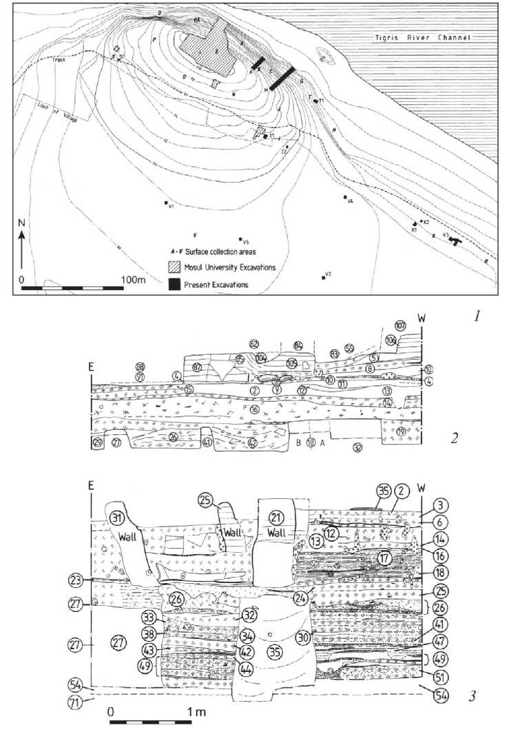
Fig. 1. Plan of Tell Abu Dhahir and sections through the lowest part of trench [M] showing Hassuna stratigraphy cut by Northern Ubaid graves and the beginning of the Ubaid occupation sequence above
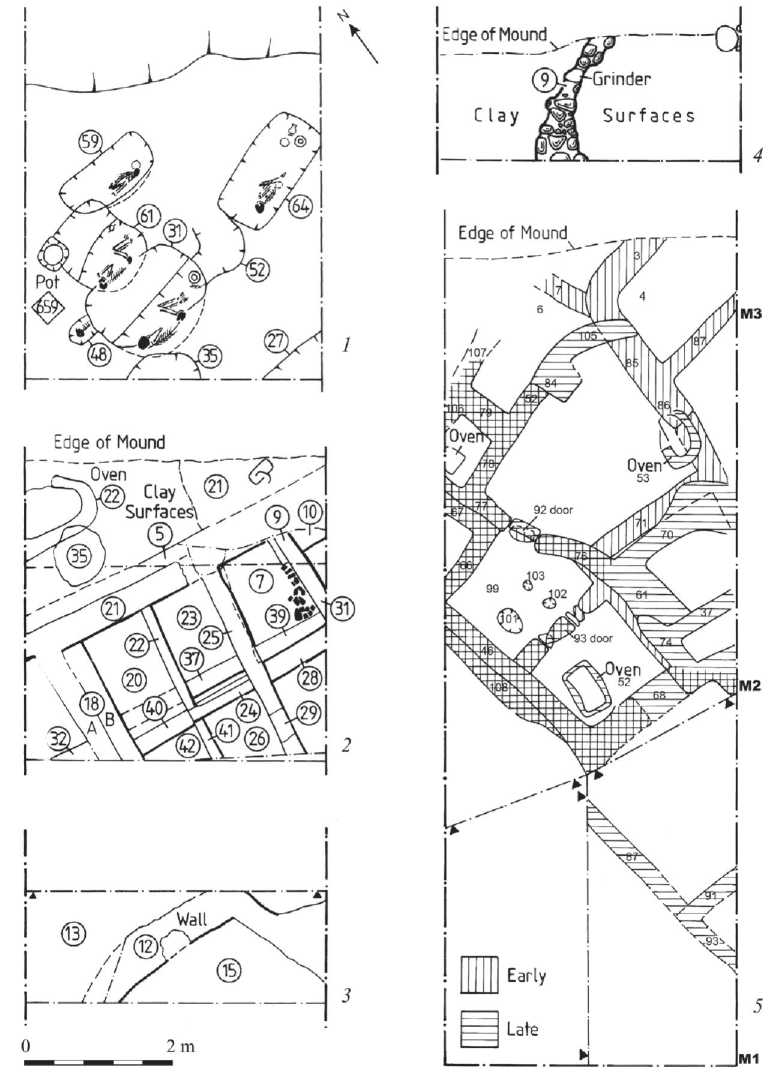
Fig. 2. Successive plans from the Ubaid sequence at Tell Abu Dhahir 1 – cemetery; 2 – cubicle building; 3 – wall; 4 – stone footings; 5 – architecture
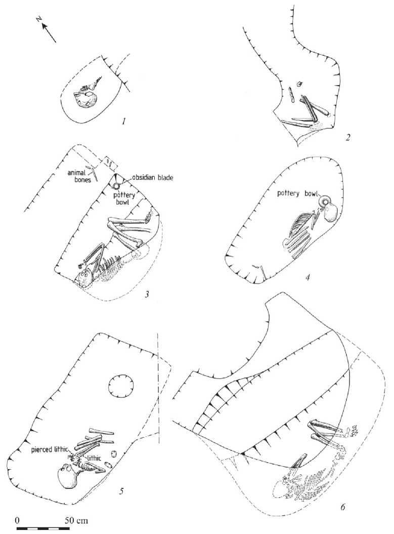
Fig. 3. Plans of the six excavated Ubaid graves in a cemetery at Tell Abu Dhahir
1 – a child; 2, 3 – adult males; 4‒6 – adult females may have been an indirect cause of death as it would have weakening the child’s resistance to infection.
Pottery grave-goods were found in the four well-preserved graves belonging to a male and the three females (Fig. 3: 4 ). In the first, a shallow painted bowl had been placed upside-down as a pillow for a female burial; the cut-down rim indicates it was already a recycled item when interred (Fig. 3: 4 ). In the second, also that of an adult female, a small group of vessels had been placed at the foot end of the alcove and consisted of a small painted jar placed upright on top of a smooth natural stone which originally served as its lid, and three bowls of different sizes, one found inside another, and the fourth, which was overfired and had been repaired in antiquity, inverted over a small hollow of uncertain function in the grave floor (Figs. 3: 5 ; 4: 1, 2 ). The third female burial contained a perforated plain pottery bowl inverted over a ledge-rim jar with holes through the ledge-rim indicating it had been designed to have a skin lid (Fig. 4: 3, 4 ). In the fourth grave – that of an adult male – a plain bowl was found placed directly on top of a bottle-green obsidian blade at the opening of the grave alcove, also at the foot end, with some animal-bones placed nearby as a food offering (Fig. 3: 3 ). A lump of red ochre was found with the pottery in one burial, and a broken smoky-grey obsidian pendant found near the wrists of this female individual (Fig. 3: 5 ).
Within the [M] sequence, this use of what already become a low mound was followed by a transformation as occupation now extended here, thus displacing the cemetery to another (unlocated) spot. The earliest structure was a cubicle building with an external bread oven; construction was in tauf and the internal partition walls of the building rebuilt as part of three sub-phases (Fig. 2: 2 ; 4: 6 ). The function of the cubicles is unknown but the presence of interior plaster and items lying flat on the floors suggest that they were used for storage rather than simply being a form of casemate construction to level up for a superstructure above. This building was then followed by two more phases with an oven in one and the stone footings for a curving wall in the second (Fig. 2: 3, 4 ), followed finally by a two-phase building with small rooms inter-connected by doorways, in one case blocked, and a bread oven was found inside one room with some flint knapping debitage (Fig. 2: 5 ; 4: 5, 7 ). Construction was again in tauf , and this might account for the curvilinear walls. The persistent use of tauf , rather than brick, appears to be part of a longer northern Mesopotamian tradition in prehistory.
A modest assemblage of Northern Ubaid 3/4 painted pottery with parallels from the Eski Mosul Dam project (Hatara), North Jazira (Khanijdal, Telul eth-Thalathat), Mosul region (Tepe Gawra, Qalinj Agha), and Hamrin basin (Tell Abada) and other finds accompanied this sequence. The latter included two polished stone celts, a banded limestone mace-head and two stone bowl fragments. Bone tools were represented by a bone spatula, perhaps used in leather working and polished from use, a bone awl and two bone points which had also been used as perforators. Similar bone tools were present in the preceding Hassuna contexts at the site, as well as at other Ubaid sites. Several stone pestles were also found: all were unmodified elongated cylindrical pebbles which had been discarded when broken. They are presumed to have been used in food processing, perhaps for marrow extraction or crushing of nuts that could not be easily shelled (such as walnuts or acorns, rather than pistachios). Four flat
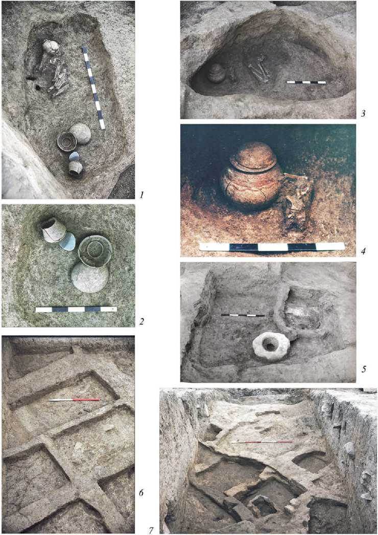
Fig. 4. Ubaid graves ( 1–4 ), cubicle architecture ( 6 ) and final architectural level with an oven ( 5, 7 )
polished black stone palettes with very distinct scratches usually orientated parallel with the long axis of the object were also found. The wear patterns imply that they had been used to process substances through grinding and traces of pigment found on similar examples from Telul eth-Thalathat, Tepe Gawra and Tell Abada suggest they had been used in the processing of pigment for cosmetic and/or pottery production. The ground stone assemblage was mostly of basalt, therefore presumably imported from north-east Syria as that is the closest source. Finally, a large number and variety of pieces of bitumen were found. Many were irregular featureless lumps, and may simply have been unused chunks or heavily worn fragments of unknown func-tion(s), but the second largest group were pieces with one or more surfaces bearing the impressions of woven matting, and a third category consisted of plain flat oval or sub-rectangular pieces which might represent convenient-sized pieces ready for re-heating. The source of the bitumen is unknown.
Conclusions
Taken as a whole, the results from this project indicate a pattern of fluctuating densities of rural settlement, sometimes accompanied by small numbers of more extensive population centres, a characteristic of this region for later periods. It challenges the common assumption of continuity that many look for as they assume stable societies accompanying the rise of civilisation and the growth of urbanism, perhaps reflecting deeper modern psychological aspirations for stability in life as the longer the sequence, the more contented many an excavator appears to be. However, all of the sites in this project had interrupted sequences, often more than once. Periodic discontinuities and abandonments were the normal pattern of settlement, rather than stable long-term occupation. Clearly, life in this valley was not straightforward or always easy. This phenomenon has been noted above in the case of the middle Euphrates and lower Khabur, and in those cases usually attributed to climatic fluctuations triggering population movement. However, this region is fertile, with constant water supply, sheltered locations with no risk of flooding and good rainfall, implying that the reasons must be human rather than environmental. There is compelling evidence from excavated sites across the valley for violent destructions of settlements during what appears to be a single phase in the mid/late 3rd millennium BC, but this was exceptional and most settlements appear to have been abandoned and left to collapse. Understanding the reasons for these now requires a more nuanced interpretation of settlement history across different ecozones and one which acknowledges the strategic value of valleys as corridors of movement and lines of control.
Sites which were not re-occupied were usually heavily eroded, and the modern topography was usually very misleading in terms of assessing depth of archaeological deposit. This is well illustrated by Tell Deir Situn where preliminary assessment and sherding suggested a multi-period site with up to three metres of deposit, but the excavated remains proved to consist of a single-period 2nd century BC building with only a few courses of stone footings. A similar situation was found at Kharabeh Shattani. The effect was even more marked at others: what appeared to be a six metre-high multi-period mound at Bardiya 8 proved on excavation to be a single-phase occupation with only half a metre of deposits above a low terrace running along the right bank of the Wadi Bardiya. The prominent mounds of Tell Karrana 1 and 3 again proved to have considerably less stratigraphy than expected initially: although the latter was interpreted afterwards as a hillock with occupation on the summit, heavy erosion around the sides suggest that it was the archaeological structures which helped preserve a cap, whereas the natural deposits around were more rapidly eroded. Inspection of sections along the Wadi Suwaidiya showed relatively high densities of potsherds which might reflect evidence for manuring, but equally could have derived from erosion of sites upstream; a small quantity of possible Ninevite 5 sherds was found among gravels in a section of the Wadi Qasrij in 1985, and pottery and crude stone tools were found up to a depth of seven metres in the Wadi Anzeh. It is telling that single-period mudbrick villages abandoned in the 1970s left no remains apart from some stone wall footings and thin artifact scatters. Once the impounding and periodic drawdown occurred, mounded sites of all sizes – including Tell Abu Dhahir itself – were undercut and washed away by the strong currents. Now the northern part of the former reservoir is farmland, but with no traces at all of Tell Abu Dhahir, while the remaining reservoir is an active zone of erosion which is the subject of renewed research as part of a ‘second phase’ of dam archaeology (Sconzo et al., 2023).
These factors have particularly important implications for appreciating prehistoric site patterns, particularly as these occupations did not use mudbrick: the proto-Hassu-na occupation at Tell Abu Dhahir relied on wood and wattle and daub, and relatively thin tauf walls were typical of the later Ubaid architecture at the same site. The use of any of these building traditions would explain the absence of any recognisable architectural remains – other than a few stone footings – at the Halaf sites. Many, if not most, seasonal or short-lived settlements therefore were probably not detected during this project, and this explains the low numbers of sites of equivalent periods recorded on the adjacent ‘Land of Nineveh Archaeological Project’ [LoNAP] survey in northern Iraq Kurdistan and along the upper Khabur valley: another case of absence of evidence, rather than evidence for absence. We should therefore exercise extreme caution in estimating population sizes at any of these periods in prehistory, and be ready for many more surprises in future.
