
Remote Arctic Settlements of Yakutia in the Context of Climate Change and Permafrost Degradation: The Case of the Argakhtakh Village
Journal: Arctic and North @arctic-and-north
Section: Northern and arctic societies
Article in issue: 63, 2026.
Free access
The article examines the consequences of the increase in average annual air temperatures and the permafrost degradation over the past decades for the population of the village of Argakhtakh, located in the Srednekolymskiy district of Yakutia, which belongs to the Arctic zone of the Russian Federation. In this regard, the author uses materials from field studies, documents from archival funds, and information presented in the scientific literature. It is noted that, by analogy with other northern rural settlements exposed to the negative impacts of environmental change, the population of the village of Argakhtakh faces a whole range of challenges as a result of such transformations. At the same time, it has been established that the remote location of this village leads to a significant increase in the risks to the sustainability of the life support system formed at the local level. In this case, the general threats are compounded by problems primarily linked to the inaccessibility of such settlements. As a result, difficulties arise not only with the maintenance of housing stock, outbuildings, and traditional economic activities, but the situation regarding transport accessibility is further exacerbated, and levels of food security and overall safety of daily life are reduced.
Short address: https://sciup.org/148334009
IDS: 148334009 | UDC: 572.021(571.56)(045) | DOI: 10.37482/issn2221-2698.2026.63.328
Text of the scientific article Remote Arctic Settlements of Yakutia in the Context of Climate Change and Permafrost Degradation: The Case of the Argakhtakh Village
DOI:
The Climate Doctrine of the Russian Federation, which was adopted in October 2023, defines the current processes of global climate change as one of the key challenges of the 21st century, and the closely related problem of permafrost degradation is recognized as a factor that adversely impacts socio-economic development, life, and health of citizens 1. This assessment requires increased attention of the scientific community to the consequences of climate change and the wide range of issues related to the state of permafrost, forming the foundation for northern communities. It is also important to note that the Arctic and Subarctic regions are currently expe-
-
∗ © Suleymanov A.A., 2026
This work is licensed under a CC BY-SA License
NORTHERN AND ARCTIC SOCIETIES
Aleksandr A. Suleymanov. Remote Arctic Settlements of Yakutia … riencing the most intense temperature changes: climate imbalances in the North are occurring faster than the global average 2.
The aim of this article is to examine, using the example of the village of Argakhtakh, the consequences of climate change and the degradation of permafrost for remote and inaccessible settlements located in the Arctic zone of the largest constituent entity of the Russian Federation — the Republic of Sakha (Yakutia).
The relevance of addressing this issue is also determined by the current historiographic situation. At present, a relatively large number of works have been published on a wide range of issues relating to climate change and its consequences for the population of Yakutia by specialists in various fields (Saito, Iijima, Basharin et al., 2018; Fedorov, Konstantinov, Vasilyev et al., 2019; Takakura, Fujioka, Ignatyeva et al., 2021; Zhirkov, Sivtsev, Lytkin et al., 2023; Vinokurova, Grigorev, 2023 et al.). Among these works, there are studies directly devoted to the situation that has developed in recent decades in the village of Argakhtakh, which examine various natural science issues (Zakharova, 2015; Gotovtsev, Kopyrina, Efimova et al., 2018; Tananaev, 2018), as well as anthropologically oriented questions (Parfenova, Nogovitsyn, 2018; Fujiwara, 2018; Suleymanov, 2022). However, the authors of these studies did not aim to analyze the consequences of climate change through the prism of the inaccessibility and remote location of this settlement in relation to higher administrative centers and important transport and logistics hubs. The author of this article hopes to at least partially fill this historiographical gap.
In this regard, it should be noted that this study is an integral part of research conducted at the “Man in the Arctic” laboratory of the Institute for Humanities Research and Indigenous Studies of the North of the SB RAS (Yakutsk), aimed at developing an integrated index of the degree of re-silience/vulnerability of local communities in rural Yakutia to the consequences of climate change and permafrost degradation. The mechanisms for assessing current and potential damage proposed on the basis of this study will make it possible to identify key risks to locally established lifesupport systems, which should be taken into account when developing strategies for the adaptation of the economy, the population and territories to climate change. This is the primary form of response to climate-related threats to sustainable socio-economic development and national security in the Russian Federation in the foreseeable future.
Materials and methods
The development of this topic was based on the results of field research conducted as part of and funded by the Russian Science Foundation project No. 19-78-10088, “Anthropology of cold: natural low temperatures in the life support systems of rural communities in Yakutia (traditional practices, modern challenges, and adaptation strategies)”, supported by the Russian Science Foundation, in March–April 2021. During this research, the author and his colleagues — Candi- dates of Geographical Sciences V.M. Lytkin and S.I. Fedorov — conducted interviews with 17 residents of the village of Argakhtakh and collected 22 sociological survey questionnaires. In addition, documents from the current archive of the Alazeyskiy nasleg administration, as well as materials from the local museum, were used in writing this article. To form a more complete picture, the author also referred to data from the Municipal Archives of the “Srednekolymskiy ulus” municipal district (Srednekolymsk) and the available scientific literature.
Subject of study: the village of Argakhtakh
The village of Argakhtakh is located in north-eastern Yakutia, on the right bank of the middle reaches of the Alazeya River, 110 km north of Srednekolymsk, the district capital of the Sred-nekolymskiy Ulus (district) (Fig. 1). The settlement is situated in the central part of the Kolyma Lowland on a floodplain terrace on the right bank of the Alazeya River with a relative elevation of 20–23 m. This area is characterized by shallow valley-like depressions without clearly defined edges and Holocene alas basins. The surface relief is predominantly flat, with widespread wetlands and thermokarst lakes (Gotovtsev, Kopyrina, Efimova et al., 2018).
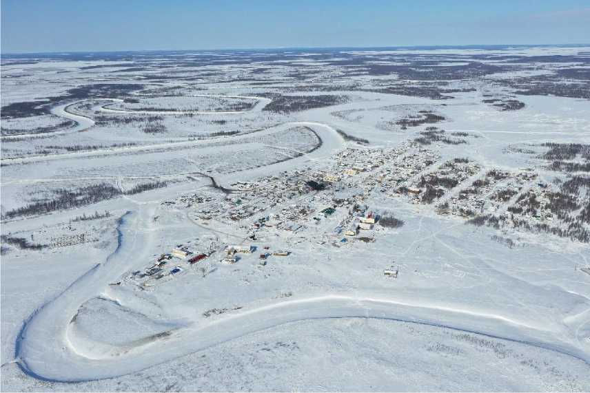
Fig. 1. Panorama of the village of Argakhtakh, March 2021. Photo by V.M. Lytkin.
The first records of a permanent settlement on the Alazeya River date back to the arrival of Russian explorers in the 1640s and their establishment of the Alazeya winter camp, which became one of the centers for the collection of yasak (a tax collected by the tsarist government from the indigenous ethnic groups of Siberia, mainly in the form of furs) (Savinov, 2020). V.I. Jochelson, who conducted research in the basin of this river at the turn of the 19th and 20th centuries, noted the presence of two Alazeya clans of the Yukagirs. Even (Tungus) clans were also recorded on the Alazeya (Jochelson, 2005). However, all this information relates primarily to the lower reaches of the Alazeya, where the Even-Yukagir village of Andryushkino and the territories to the north of it are now located. As noted, this area is administratively part of the Nizhnekolymskiy district.
The territory of modern Srednekolymskiy ulus (district), according to I.S. Gurvich, was populated predominantly by Yakuts. They tended to settle along the shores of lakes located in the lowlands between the Kolyma River and the Alazeya Plateau. The main economic activities of this ethnic group were cattle and horse breeding 3.
The further development of this area was largely linked to the policy of collectivization and settlement carried out in northern Yakutia in the 1930s–1950s, which involved concentrating the scattered indigenous peoples of the North — many of whom led a nomadic lifestyle — in newly established settlements. Moreover, new settlements were no longer located near lakes, as was common among the Yakuts, but along river banks (Sannikova, Filippova, Vinokurova et al., 2016).
In 1934, a decision was made to establish the Alazeyskiy nasleg, the administrative center of which was initially located in the village of Kien-Kyuel. By this time, Argakhtakh was apparently a small seasonal settlement. On the 1946 USSR map, it is marked as a winter hut 4. The village of Argakhtakh, in its form close to the modern one, dates back to the early post-war years (Kokorin, 2000). Based on the fact that the village was also mentioned in some Soviet-era documents under the name Argakhtakh-Orlovo 5, it is likely that a significant portion of the population at this stage consisted of settlers from the village of Orlovo, located less than 20 km upstream of the Alazeya River. The liquidation of the remaining settlements in the Alazeyskiy nasleg continued until the end of the Soviet period in the history of Yakutia and was completed in the late 1980s, thus establishing the present-day isolated status of the village of Argakhtakh (Kokorin, 2000).
Argakhtakh is currently the administrative center and the only settlement within the Alazeyskiy nasleg of the Srednekolymskiy ulus (district) of the Republic of Sakha (Yakutia). The nasleg is located in the north-western part of this ulus and covers an area of 7,207.10 km². The distances to the nearest existing settlements are as follows: 59 km as straight to the east to the village of Oyusardakh, 66.2 km to the north-west to the village of Aleko-Kyuyol, 78 km to the south-west to the village of Svatay, 96 km to the south to the village of Nalimsk in the Sred-nekolymskiy district, and 93.1 km to the north to the village of Andryushkino in the Nizh-nekolymskiy district. However, there are no year-round transport links to any of these settlements. In summer, the villages of Svatay and Andryushkino can be reached by motorboat along the Alazeya River; in winter, the villages of Andryushkino, Nalimsk, and the town of Srednekolymsk can be reached via the “Arktika” winter road.
The population of the village of Argakhtakh, which had grown steadily throughout the Soviet period (300 people in 1959, 495 people in 1970, 708 people in 1989), also began to decline after the collapse of the USSR. By the time of the 2002 census, 581 people lived there; by 2021, the figure had fallen to 469 6. The overwhelming majority of the inhabitants of this settlement are traditionally Yakuts (Sakha). The language of interpersonal communication is generally Yakut — it was easier for most of our informants to give interviews in this language.
A significant factor influencing population dynamics was the activities of the Alazeiskiy state farm (during the period of state farm development, its central estate was located in Argakh-takh). Its core activities included dairy and beef cattle breeding, meat-producing horse herding, fur farming, fur trapping, fishing, and reindeer herding 7. A fairly large state farm by the standards of Polar Yakutia, it was for a long time the main employer in the village. The socio-economic crisis of the late 20th century and the radical change in the country’s economic conditions led, as was the case with other actors in the agricultural development of Yakutia, to a significant reduction in the scale of operations at the Alazeyskiy state farm. However, unlike most similar structures, it survived until the second half of the 1990s, albeit in an altered form. The current basis of Argakhtakh population’s livelihood consists of the public sector (the nasleg administration, school, kindergarten, boiler house, hospital, etc.), and, to a lesser extent, traditional economic sectors: livestock farming, fishing and hunting 8.
During the Soviet period, a pumping station was commissioned in the village, and several two-storey apartment blocks were built, constructed from sawn timber and erected on a foundation of larch piles. These buildings, connected to central heating, are still in use today. However, the housing stock consists mainly of detached houses, more typical of rural Yakutia, each occupied by a single family 9.
Climate change and its impact on the village of Argakhtakh
According to the Srednekolymskaya meteorological station, the area in question is characterized by a steady increase in average annual air temperature. Whereas in the 1960s, the average annual air temperature was –12.6°C, in the 1990s, it was –11.9°C; in one particular year (1995), for the first time in the history of observations, this figure fell below –10°C (–9.7°C). In the 2000s, the average annual air temperature was already –10.4°C. This record was broken in 2007, when the average annual air temperature was –8.7°C. In the 2010s, this figure was above –10°C. As a result, the average annual air temperature in this decade was only –9.7°C 10. Thus, compared to the 1960s, the average annual air temperature, according to observations at the Srednekolymskaya meteorological station, has increased by almost 3°C (Fig. 2).
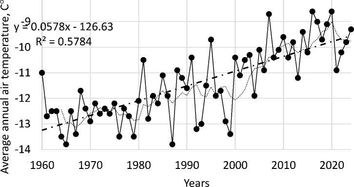
Fig. 2. Average annual air temperature trends in 1960–2024, according to data from the Srednekolymskaya meteorological station: 1 — average annual temperature; 2 — linear temperature trend; 3 — sliding 5-year temperature 11.
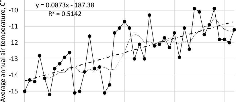
A similar trend was recorded at the Andryushkino meteorological station, located closer to Argakhtakh. In the 1980s, when observations began there, the average annual air temperature was –12.5°C; in the 2010s, it was already –11.4°C. Moreover, in 2016, for the first time in the history of observations, this figure was above –10°C (–9.9°C) 12.
-9
-16
1982 1992 2002 2012 2022
1 Ye2ars 3
Fig. 3. Average annual air temperature trends in 1982–2024, according to data from the Andryushkino meteorological station: 1 — average annual temperature; 2 — linear temperature trend; 3 — sliding 5-year temperature 13.
URL:
URL:
URL:
The informants we interviewed, speaking from their subjective perception of the ongoing climate changes, noted the following: “The climate is changing, it’s getting warmer. There’s more snowfall, and it’s ‘different’” (A.I., aged approx. 55, female); “Seasons are changing. Autumn is longer and warmer. It rained for the first time in October” (born 1959, male); “The climate has been changing since the 1980s. I believe this is linked to the fact that large lakes were drained during the Soviet era. As a result, the natural balance was disrupted. Overall, it’s getting warmer. However, spring used to last longer. For example, on February 23rd, we were already playing volleyball outside. Now that’s impossible — it’s cold” (N.S., born 1942, male). The information provided by another of our informants — an employee of the local diesel power plant (aged approx. 35, male) — is also of interest. In recent years, his family has started planting potatoes in open ground, whereas previously, in the conditions of Argakhtakh, this vegetable crop could only be grown in specially constructed beds 14.
Argakhtakh, as noted, is situated on the banks of the Alazeya River. This river plays a vital role in sustaining the livelihood of the inhabitants of the village of Argakhtakh. For example, it supplies water for the pumping station, fishing is conducted there. Furthermore, local people also use the Alazeya River to reach their remote hunting grounds. This traditional role of the river in rural settlements of Yakutia is associated, as in other cases (Vinokurova, Filippova, Suleymanov et al., 2016), with equally regular challenges for the population, primarily flooding.
During the Soviet period, the village and the adjacent agricultural land were subjected to flooding caused by high water levels on the Alazeya River in 1958, 1968–1969, 1977–1978, and 1985. In 1969 and 1978, the water level reached 807 cm, while the critical level for the village is 782 cm 15. Due to several characteristics of the Alazeya’s flow, this river is characterized by prolonged rises in water levels, typically lasting for weeks or even months.
The informants we interviewed, even the elderly, did not attach much importance to the reported floods during the Soviet period, as, according to them, there was virtually no threat to the village itself at the time. The floods primarily affected agricultural lands. There is no information about any damage to residential buildings or other structures due to flooding in Argakh-takh, nor in the archival documents reviewed by the author 16.
The situation began to change as the noted climate changes intensified. One of their consequences was an increase in the amount of precipitation, as well as the depth of the seasonally thawed layer (Gotovtsev, Kopyrina, Efimova et al., 2018). This led to an increase in the volume of supra-permafrost groundwater and the activation of thermokarst and thermoerosion processes (Gotovtsev, Kopyrina, Efimova et al., 2018). The latter “provoked the spontaneous drainage of watershed lakes” (Gotovtsev, Kopyrina, Efimova et al., 2018). For this reason, “in certain sections of the Alazeya River valley, a large volume of water accumulated, which, due to the shallow slope
and limited natural cross-section of the river bed, formed large-scale floods in the valley part” (Gotovtsev, Kopyrina, Efimova et al., 2018). As a result, in the summer of 1997, the river’s water level significantly exceeded the critical mark, reaching 834 cm (the water level remained above the critical mark from early July until the second half of September). In 2000, this figure reached 835 cm, in 2002 – 802 cm, in 2007 – 869 cm, in 2017 – 897 cm, and in 2018 – 821 cm. In 2017, for example, the water level above 782 cm remained from June 29 to September 19, and in 2018 – from July 5 to August 13 17. During this time, a state of emergency was in effect in the village, and part of the population was evacuated.
Transport accessibility and connectivity of the living space
Before proceeding to analyse the consequences of the noted flood events for the residents of the village of Argakhtakh, it is worth noting that, in addition to the prolonged period of rising water levels, this river has other specific characteristics, including its isolated location (it is not a tributary of a larger river serving as a transport artery, it does not connect Argakhtakh to any settlement that is more accessible in terms of transport) and a significant meandering channel. Consequently, the Alazeya has no significant transport or logistical significance for the local population. The main burden naturally falls on land and air transport.
The latter method of providing transport links between Argakhtakh and the outside world has not played a significant role in recent years due to the aforementioned flooding on the Alazeya River. As J. Fujihara notes, the 2007 flood left the village’s inhabitants without air transport for almost two years, as the local airstrip was flooded (Fujiwara, 2018). The “great flood” that occurred 10 years later flooded and damaged this airstrip so much that only expensive helicopter service was possible.
An official from the nasleg administration, informant V.V. (born 1975, male), described the changes as follows: “Unfortunately, our airstrip is not only unusable at present, but is clearly beyond repair. After it was flooded, it’s completely uneven and covered in tussocks. Restoring it to working order requires significant financial investment. After all, think of the distances the equipment would have to be transported, how much of it would be needed, and how long it would be working here, consuming fuel that would also have to be delivered. Now, in the summer, the only link to the outside world is by helicopter. This is significantly more expensive for our residents. Flights are only available twice a month. It’s clear what problems this creates, including with planning vacations, and then you still have to get out of Srednekolymsk.” 18
Helicopter flights are often not tied to specific dates, but are operated when the aircrafts are filled with passengers. As a result, the only relatively reliable and accessible means of transport is the aforementioned “Arktika” winter road, which is laid annually across the surface ice of water bodies, and frozen ground from the “Kolym” federal highway to Chukotka (Fig. 4). For the remaining 8–9 months of the year, the population of Argakhtakh essentially lives in anticipation of the next construction of a winter road to their village.
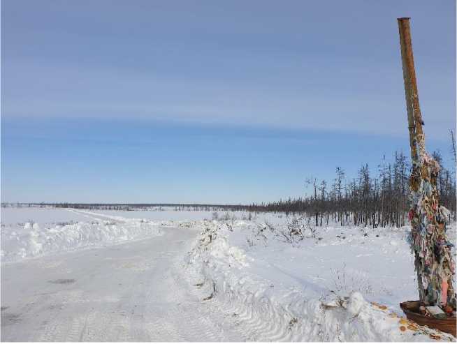
Fig. 4. The “Arktika” winter road between Nalimsk and Argakhtakh, March 2021. Photo by the author.
In this context, the duration of operation of this “road of life” is particularly important, as it depends, among other things, on the rate of formation of stable ice cover on the numerous water bodies of north-eastern Yakutia. One of the informants we interviewed, V.V. (born 1975, male), responding to a question about possible changes in the service life of the winter road, noted that while in the 1980s and 1990s it was opened in November, now — only in January or February. He attributed these changes, among other things, to global warming. Furthermore, according to the informant, previously, “each village council laid the road on its own territory. When you do it yourself, it gets done faster.” Another informant (born 1960, male), one of the few remaining cattle owners in the village, also noted that the winter roads began to open later. However, he attributed this to economic factors: “it is not profitable for them (the relevant management structures — A.S.) to maintain and clear the winter road for a long time. The climate has nothing to do with it.” Our informant, A.I. (female, aged 55), also agrees that the winter road’s opening dates have been “shifted”; she noted that, due to similar supply problems, Argakhtakh stores ran out of flour and a number of other essential products in the summer of 2020 19.
Comparing the data received from informants, which is largely subjective in nature, with objective data, it seems necessary to note that it generally corresponds to reality. As regards the organization of winter roads during the Soviet period, it has not yet been possible to identify the minimum necessary information. However, while in the 1990s, the opening dates for the road now called “Arktika” approximately corresponded to those of today, it was closed to traffic in mid-
May 20. Currently, the winter road opens on average at the end of December for vehicles weighing up to 20 tons, and towards the end of January for those exceeding 30 tons; it closes at the end of April 21. For example, in 2023, through traffic for all vehicles on the “Arktika” winter road was opened on January 20 and closed on April 24. Thus, based on the data provided, compared to the late 20th century, the period of use of the winter road passing through the village of Argakhtakh has been reduced by more than half a month.
Regarding the Argakhtakh population’s perception of the role of the “Arktika” road and the concerns they have in this regard due to climate change, it is significant that a sociological survey conducted by the author and his colleagues from 2017 to 2023 revealed the following: in the Amginskiy, Verkhnevilyuyskiy, Megino-Kangalasskiy, Oymyakonskiy, Olyokminskiy, Sred-nekolymskiy, Ust-Aldanskiy, and Khangalasskiy districts (uluses) of Yakutia, 831 people (75.8%) noted a strong dependence of their settlement on the condition of winter roads and ice crossings. At the same time, 425 respondents (38.7%) identified deteriorating transport accessibility to their locality as the main threat posed by climate change during the winter. In Argakhtakh, 90.9% and 86.3% of those who took part in our survey gave similar responses, respectively.
Traditional economic activities
As noted, the Yakuts living in the Alazeya River basin were traditionally engaged in cattle and horse breeding. Additional activities included hunting, fishing, and gathering wild plants. During the Soviet period, fur farming, represented by the breeding of blue and silver foxes, was actively introduced throughout Yakutia. The effects of climate change and permafrost degradation have impacted each of these industries to a greater or lesser extent.
Moreover, these climatic challenges coincided with the general economic crisis in our country. As a result, for example, in the village of Argakhtakh, as in many other rural settlements in Yakutia, people ceased to engage in fur farming, which proved unprofitable under the new circumstances. However, in the Alazeya basin, this was largely caused by flooding. In 1997, the “great flood” in Argakhtakh resulted in the formation of a new branch of the river, which ran between the main part of the village and the local fur farm. Consequently, maintaining its operations became significantly more resource-intensive, as the fur farm was only provided with a stable land link to the village during the winter months. Despite this, the fur farm in the village of Argakhtakh survived significantly longer than most similar facilities in the region. In 2015, it housed 45 animals. The fur farm was closed only after the flood of 2017 22.
The 1997 floods had a serious impact on livestock farming as well. The prolonged rise in water levels led to the closure of almost all pasture lands in the vicinity of the village. As these lands remained covered in silt in subsequent years, forage grasses could not grow there. Considering that by this time the village’s farms had 495 head of cattle and 670 head of horses 23, the current situation necessitated the use of more remote lands. This increased the burden on motor vehicles, which, given the difficulty of delivering fuel to Argakhtakh, led to a significant rise in the financial burden on local businesses 24.
The situation was further complicated by the 2007 flood. V.I. Zakharova, a Candidate of Biological Sciences at the Institute for Biological Problems of Cryolithozone of the Siberian Branch of the RAS, who conducted research on Alazeya, found that it had a profoundly negative impact on the natural systems used by the Argakhtakh villagers in their traditional economic activities: “Significant damage was caused to agricultural lands, the food supply for waterfowl and wild animals, as the coastal vegetation of the river valley and floodplain lakes was destroyed. Due to the prolonged standing of floodwaters, coastal trees and shrubs were destroyed over large distances, thereby reducing the percentage of forest cover in the area. Along the banks of rivers and floodplain lakes, large areas were covered by bare hummocks, thereby reducing the area of hayfields and pastures for livestock, especially near populated areas. For example, residents of the village of Argakhtakh were forced to transport their livestock to distant lands for the entire summer, 30–40 km from the village, incurring unforeseen expenses. Hummocks up to 70 cm high formed in the forest due to subsidence of permafrost, and the same occurred in tundra-bog complexes covering vast areas” (Zakharova, 2015).
The floods of 2017–2018 resulted in the inundation of 85% of agricultural land and 50% of the hay harvested by residents of the village of Argakhtakh 25. As a result, the cattle population, which numbered 139 in 2015 (more than three times less than in 1997), had declined to 87 by 2019. Of this loss, 25 head (44%) occurred in 2017, when residents were forced to slaughter cattle due to the inability to feed them (Fig. 5) 26.
MAMD SU. F. 1. Invt. 5. Arch. 118. Sh. 5.
FMA, March 2021, Argakhtakh village, Srednekolymskiy ulus (district) of the RS (Ya).
CA AMF AN.
CA AMF AN.
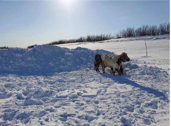
Fig. 5. Cattle in the village of Argakhtakh, which has significantly decreased in recent decades, March 2021. Photo by the author.
Another negative phenomenon that local residents associate with floods is the change in the fish stock of the surrounding lakes and the decrease in the number of various game animals: “During floods, all the fish from the lakes migrate to the Alazeya River. There are very few fish in the lakes now. Moreover, the flood washed away all the muskrat burrows, and these animals became very rare. Furthermore, wild deer stopped coming here because their food supply was washed away, and they have nothing to eat here.” (V.V., born 1975, male). Another respondent, M.S. (approx. 60, male), confirms this: “Bird migration seasons have shifted. Bird migration has changed; scoters are nesting further north. Wild deer and moose migration has also changed; they are now more difficult to hunt. We have to travel further, using more petrol. In other words, because of the fires and climate change, the animals have moved further north.” 27
The need to diversify fishing grounds and conduct hunting at a greater distance from the village of Argakhtakh naturally entails additional time and financial costs, aggravated by the increasing inaccessibility of this settlement — the products of subsistence activities have traditionally been a vital component of the village residents’ food security. Given the growing risk of insufficient food supplies to retail outlets, as was in 2020, such difficulties with hunting and fishing reduce the reliability of these activities.
Housing stock and livelihood practices
Floods on the Alazeya River also caused damage to housing stock and outbuildings in the village of Argakhtakh. In 1997, one residential building, a new diesel power plant building, and several outbuildings were flooded 28. A decade later, 29 households were affected. Officially, the
material damage to the village amounted to 8.6 million rubles, which was primarily spent on restoring damaged transport links. According to calculations by economist O.T. Parfenova, the financial damage amounted to 1,629 million rubles (Parfenova, Nogovitsyn, 2018). The scale of the 2007 disaster, according to J. Fujiwara, led to the development of plans to resettle Argakhtakh residents. However, only 27 people agreed to move to the city of Srednekolymsk (Fujiwara, 2018). Incidentally, the local population’s attachment to their homeland and their reluctance to leave it were also noted by the author during his own field research. In particular, only 13.6% of respondents accepted this type of adaptation to emerging climate challenges 29, despite the fact that 22 residential buildings were again flooded by the Alazeya River in 2017–2018 30.
As a result, given the aforementioned duration of the floods, the village’s housing stock suffered significant damage — the foundations of houses rotted due to prolonged exposure to water and the inability to dry out before the onset of winter. This, in turn, impacted the well-being of the local population, some of whom were forced to build new homes to replace those damaged by the natural disaster. The example of informant N.S. (born 1942, male) is illustrative in this regard: “We lived in that house for 40 years, which, unfortunately, after the floods, became uninhabitable. The foundation rotted. We had to build a new house nearby, which is where you are now. We feel sorry about it — we raised our children in that house. It could have served us for many years more. Well, and the costs, you, you know…” 31.
Considering Argakhtakh’s remoteness, its increasing transport isolation, unsuitability of the local forest resources for major construction, and significant increase in the cost of building materials in recent years, the recurrence of floods expected by experts and local residents could undermine the already low standard of living.
It is also important to note another consequence of the floods on the Alazeya River and changes in air temperature. As a result of the “great flood”, several icehouses (structures embedded in the permafrost used for storing food and fodder) used by the residents of the village of Ar-gakhtakh were inundated (Fig. 6). Some of these icehouses were unable to be restored, and others no longer retained the cold. One of our informants (born 1959, male) drew interesting parallels in this regard: “Cellars (locals use either this word or “icehouses” to refer to storage facilities in the permafrost – A.S.) are currently in use in the village; only those in the lowlands were flooded. Some of them have been successfully restored. However, for example, whereas mine used to be like a “freezer”, it’s now more like a “fridge”. It’s not as cold as it used to be.” 32
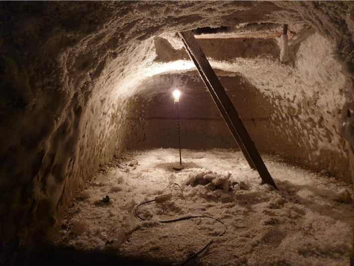
Fig. 6. One of the icehouses used in the summer in the village of Argakhtakh, March 2021. Photo by the author.
Returning to the issue of ensuring food security at the local level, it should be noted that the icehouses used by residents of Argakhtakh during the summer primarily store products from fishing, hunting, and livestock farming. These reserves also serve as a kind of safety net in the event of supply disruptions to the village, similar to the situation in 2020. Against the backdrop of icehouses melting (Tananaev, 2018) and the resulting reduction in the cold reserves they provide, the risks to the reliable food supply for the local population appear to be increasing. Furthermore, icehouses are also an important component of the ethno-cultural identity of northern communities (Nyland, Klene, Brown, 2017).
Conclusion
Thus, as the example of the village of Argakhtakh demonstrates, the risks to the sustainability of locally established life-support systems, arising from the effects of climate change and the degradation of permafrost, increase significantly in the case of remote Arctic settlements. The inaccessibility of such settlements exacerbates the problems typical for other rural settlements of Yakutia, where negative changes in the state of the environment occur due to the increase in average annual air temperatures (Takakura, Fujioka, Ignatyeva et al., 2021; Zhirkov, Sivtsev, Lytkin et al., 2023; Vinokurova, Grigorev, 2023). As a result, in addition to difficulties with the preservation of housing and outbuildings, the scale of engagement in economic activities traditional to the peoples of the North is declining at a significantly faster rate. The shift in the habitats of game animals and birds, as noted by informants, and the need to use more remote fishing grounds lead to increased consumption of material resources, the delivery of which to the village of Argakhtakh is quite difficult. Furthermore, the aforementioned challenges to traditional economic activities are compounded by the curtailment of opportunities to exploit icehouses and, combined with the limited duration of food supplies to the village, increase the risks to food security there. Finally, cli- mate change is leading to even greater transport isolation of the village and, overall, increasing threats to livelihoods. All of this poses challenges for Russian government agencies and the scientific community to organize systematic monitoring of climate-related risks for remote Arctic settlements in our country.
