
Changes in the land cover of Absheron and southeastern Gobustan under the influence of desertification processes
Journal: Anthropogenic Transformation of the Natural Environment @atps-psu
Section: Трансформация природной среды
Article in issue: 1 т.12, 2026.
Free access
The relevance of the study is driven by the need to assess land degradation on the Absheron Peninsula and southeastern Gobustan under conditions of global climate change and intensive technogenic impact. The complex ecological background of the region, shaped by long-term oil extraction and urbanization, significantly accelerates desertification processes. The main objective of the work is to analyze the spatial-temporal dynamics of the region's land cover. The research tasks include the calculation of vegetation indices, diagnostics of the state of gray-brown soils (Calcisols), and identification of factors causing their degradation. Material and methods. Remote sensing data (Landsat) were used to calculate the Normalized Difference Vegetation Index (NDVI). Field studies included semi-stationary observations at 16 plots. Laboratory analyses were conducted using the Tyurin method (organic matter) and the Kachinsky method (particle size distribution). Soil classification is based on the works of V.R. Volobuev (1966) and M.E. Salaev (1991) and is brought into line with the international WRB system. It was established that the soil cover in areas of long-term oil production has undergone severe degradation. Based on field and laboratory studies, precise quantitative parameters for four stages of gray-brown soil degradation were determined: humus content in the "A" horizon decreases from the initial 1.3-1.5% to critical values of <0.5%, absorption capacity drops from 18.5-21.5 to 15.0-17.5 meq/100g, and the soil pH shifts from weakly alkaline (7.8-8.0) to strongly alkaline (-9.0). Soil bulk density increases from 0.9-1.1 to -1.6 g/cm³, while the physical clay fraction expands from 48.0-52.5% to 76.5-78.0%. The average soil surface temperature during the 2024 growing season rises across the degradation stages from 19.4-23.1°C to 31.4-35.2°C, correlating with a decline in projective vegetation cover from 55-60% to 0-5%. The analysis showed that on the Absheron Peninsula, technogenic factors prevail over natural ones. However, sustainable anthropogenic measures (the development of almond and olive plantations) demonstrate high potential for soil fertility restoration during the initial stages.
Similar articles in the section General geography. Science of geographical factors (systematic geography). Theoretical geography
Short address: https://sciup.org/147254184
IDS: 147254184 | UDC: 911.52:631.459(479.24) | DOI: 10.17072/2410-8553-2026-1-79-86
Изменения наземного покрова Апшерона и юго-восточного Гобустана под влиянием процессов опустынивания
Актуальность исследования обусловлена необходимостью оценки деградации земель Апшеронского полуострова и юго-восточного Гобустана в условиях глобального изменения климата и интенсивного техногенного воздействия. Сложный экологический фон региона, сформированный длительной нефтедобычей и урбанизацией, существенно ускоряет процессы опустынивания. Основная цель работы заключается в анализе пространственно-временной динамики наземного покрова региона. В задачи исследования входит расчет вегетационных индексов, диагностика состояния серо-коричневых почв (Calcisols) и выявление факторов их деградации. Материал и методика. Для расчета нормализованного относительного вегетационного индекса (NDVI) использовались данные дистанционного зондирования (Landsat). Полевые исследования включали полустационарные наблюдения на 16 площадках. Лабораторные анализы проводились с использованием метода Тюрина (органическое вещество) и метода Качинского (гранулометрический состав). Классификация почв основана на трудах В.Р. Волобуева (1966) и М.Э. Салаева (1991) и приведена в соответствие с международной системой WRB. Установлено, что почвенный покров в зонах длительной нефтедобычи подвергся сильной деградации. На основе полевых и лабораторных исследований определены точные количественные параметры четырех стадий деградации серо-коричневых почв: содержание гумуса в горизонте «А» снижается от начальных 1,3-1,5% до критических значений <0,5%, емкость поглощения падает с 18,5-21,5 до 15,0-17,5 мг-экв/100г, а реакция среды смещается от слабощелочной (pH 7,8-8,0) до сильнощелочной (pH -9,0). Плотность почвы возрастает с 0,9-1,1 до -1,6 г/см³, а содержание физической глины увеличивается с 48,0-52,5% до 76,5-78,0%. Средняя температура поверхности почвы в вегетационный период 2024 г. увеличивается по стадиям деградации от 19,4-23,1°C до 31,4-35,2°C, что коррелирует с сокращением проективного покрытия вегетации с 55-60% до 0-5%. Анализ показал, что на Апшероне техногенные факторы превалируют над природными. Однако устойчивые антропогенные мероприятия (развитие плантаций миндаля и оливы) на начальных этапах демонстрируют высокий потенциал восстановления плодородия почв.
Text of the scientific article Changes in the land cover of Absheron and southeastern Gobustan under the influence of desertification processes
НЙЩ
In the XXI century, studying the desertification process in arid regions of the world and developing comprehensive measures against it are considered extremely important problems. This global concern is particularly salient in regions like Azerbaijan, where arid and semi-arid landscapes are highly susceptible to ecological degradation, with nearly 60% of pasture lands experiencing desertification (Mammadova et al., 2024; Qurbanov, Mustafayev, 2022). Currently, in regions that are experiencing desertification, a significant amount of financial resources are required to partially alleviate the effects of this process. One of the regions where the problem is relevant is the Caspian coastal region. This region is exposed to the negative effects of the arid and extra-arid regime of Central Asia along a wide front from the east. The Absheron Peninsula, which is our research region, and the adjacent southeastern Gobustan geographical area are also at the center of influence of this process. This place, having extreme conditions in terms of nature within the Republic, is also highly exposed to anthropogenic impact. The territory, almost as a whole, forms a complex urban ecosystem.
The gray, gray-brown, and partially light gray-brown soils formed in the study area have been highly degraded in the arid stage and have undergone structural and functional disruptions.
The absolute altitude in the study area and its adjacent geographical territory ranges from –28 m to 200-400 m. In terms of climate, the area is characterized by its aridity. Moving from the northwest to the southeast, towards the Caspian Sea, the altitude decreases while aridity increases; consequently, automorphic soil-forming conditions are replaced by semi-hydromorphic and hydromorphic conditions. The average annual temperature fluctuates between 13°C and 14.5°C. The average temperature of the coldest month (January) ranges from 0.2°C to 2.1°C, while the hottest month (July) ranges from +20°C to +27°C. The sum of active temperatures above 10°C is between 4200°C and 4800°C. In the areas where gray and gray-brown soils are formed, the annual precipitation varies between 110 mm and
232 mm. The vegetation primarily consists of the wormwood-ephemeral group.
According to D.I. Shasko's humidity index (Md), more than 60% of the Republic of Azerbaijan consists of dry, semi-arid and arid areas (Ayyubova A.D., Hajiyev, 1984).
Absheron and southeastern Gobustan have the lowest Md index, at 0.10-0.15. In some areas of the study region, this index is <0.10.
For many years, geographical literature discussing the nature of Azerbaijan has described the Caspian coastal region, including Absheron and southeastern Gobustan, as an arid area and evaluated as a semi-desert bioclimatic zone. In geobotanical studies, the vegetation cover of these areas is given as desert vegetation. From the point of view of existing criteria and comparison, we consider both approaches correct. Thus, soil scientists and geobotanists indicate these components as indicators. In Absheron and southeastern Gobustan, both components reflect the characteristic of the desert. From a geographical perspective, aridity is based on climatic indicators. A number of indices are known in this direction (Budyko, 1974; Dobrovol'skiy, 2002; Zonn, Orlovskiy, 1984). According to these indices, the territory of the Republic of Azerbaijan is included in the semi-arid zone. However, there are areas on the western coast of the Caspian Sea that have undergone rapid desertification and local desertification foci have formed. These lands have gradually been degraded against the background of the interaction of natural and anthropogenic factors, have lost their biological function, and have undergone serious compositional changes.
Fundamental studies on the justification and typology of desertification at the global and regional levels were conducted by Zonn (Zonn, 1983; Zonn, 1995). On a regional scale, the desertification process in the Caspian coastal region was studied and assessed by Bananova1, 2, Zalibekov (Zalibekov, 2002), and Rozanov (Rozanov, 1986). Despite these fundamental works, the rapid transformation of the Absheron Peninsula's landscape under the dual pressure of climate change and intensive industrialization requires a more detailed, modern assessment using remote sensing and precise soil diagnostics.
The aim of this research is to evaluate the spatial and temporal dynamics of land cover transformation in the Absheron Peninsula and southeastern Gobustan under the influence of contemporary desertification processes.
Research object, materials and methods
The study area geographically surrounding the Caspian coastal region covers an area of about 310 thousand ha. This is an arid area in terms of nature, intensively exposed to the influence of exodynamic processes, and is exposed to anthropogenic impact increasing every day and every hour. In such an area, a methodologically correct approach to the problem is required to assess the impact of the desertification process on the surrounding land cover.
The soil classification of the study area was conducted in accordance with the principles of genetic soil science in Azerbaijan (based on the works of V.R. Volobuev (1966) and M.E. Salaev (1991). The primary soil types in the region are gray-brown, gray, and light gray-brown soils. According to the international WRB (World Reference Base for Soil Resources) classification, these soil units are identified as Calcic Castanozems and Gypsic Cambisols.
The development and assessment of the concept of anthropogenic desertification against the background of the modern nature of the Absheron Peninsula and southeastern Gobustan is quite difficult from the point of view of a methodological approach. Because the process is under mutual influence. Therefore, during field studies, different observation and experimental areas were selected, taking into account the degree of natural and anthropogenic impact (fig. 1 / рис. 1).
The analysis on various soil and water samples was determined based on a general chemical method. These analyses reflect a number of physical and chemical indicators of the soil.
To assess the dynamics of anthropogenic desertification during the 2014-2024 period, key semi-stationary monitoring plots (fig. 1 / рис. 1) were established, differing in the degree and nature of technogenic load (oil extraction areas, agricultural lands, urbanized landscapes). Soil sampling was conducted from genetic horizons and fixed layers (0–20 cm, 2040 cm) using the envelope method. The physicochemical properties of the soils were determined using standard methodologies commonly accepted in soil science.
Total humus content: determined by the Tyurin wet combustion method (oxidation of organic matter with a potassium dichromate solution in sulfuric acid); Particle size distribution: determined by the Kachinsky pipette method with preliminary sample preparation using sodium pyrophosphate. The content of the "physical clay" fraction (<0.01 mm) was evaluated; Water extract (salinity): the analysis of the total content of easily soluble salts, the composition of anions (Cl⁻, SO₄²⁻, CO₃²⁻), and cations (Ca²⁺, Mg²⁺, Na⁺) was conducted using titration and flame photometry.
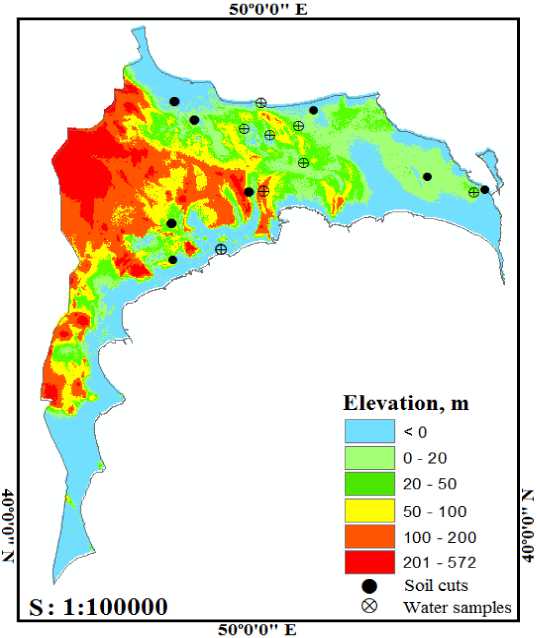
Fig. 1. The study region and selected sample and experimental sites
Рис. 1. Исследуемый регион и выбранные участки для отбора проб и проведения экспериментов
When assessing the impact of anthropogenic processes on land cover, monitoring results of desertification processes conducted in different years in the Caspian coastal regions were used.
According to thematic maps with different content compiled based on Landsat 7, 8 satellite images reflecting different years, negative and positive directions of anthropogenic processes were determined.
Results and disccusions
First, the impact of the deflation process on different ecosystems of gray-brown soils widespread in the study region was studied. Based on the experience gained in 2024-2025, the amount of different soil fractions transported and deposited under the influence of winds in various landscapes of the northern part of the Absheron Peninsula and southeastern Gobustan was calculated. Thus, according to our calculations, in the area of the Novkhani experimental site in the northwest of the Absheron Peninsula (geographical coordinates: 49°47'26.647"E 40°34'23.035"N), where the projective cover consisting of ephemerals is 25-30%, the amount of particles consisting of various fractions transported from the soil surface as a result of deflation varies between 2.53.0 tons/year. In the Balakhani oil production region (geographical coordinates: 49°54'1.545"E 40°27'35.102"N), the average project cover of ephemerals in the allocated experimental area is 25-30%. The annual amount of soil fractions blown away as a result of deflation was 3.5-4.0 t. However, in the eastern part of Absheron, within the Dubendi area (geographical coordinates: 50°17'56.058"E 40°24'7.457"N), the projective cover was 45-50%, and this amount changed between 1.5-1.6 t. as a result of deflation within a year.
In the gray-brown soils of southeastern Gobustan, under a 3-4 year-old olive grove (geographical coordinates: 49°48'2.971"E 40°24'5.594"N), the projective cover was 35-40%, and the material removed was calculated to be 2.5-3.0 tons/year. In the territory of Garadagh district of southeastern Gobustan (geographical coordinates: 49°42'27.358"E 40°15'46.425"N), the projective cover was 0%, and the material removed in the area completely devoid of plants was 11-12 tons/year.
The evolution and degradation of soils in various ecosystems of the study area are related to the functional activity of biological factors. That is, the geobotanical characteristics of plants, their biomass and the length of the soil-plant relationship, that is, the vegetation period. In the natural environment of the semi-desert and desert areas of the region, the normal vegetation period in the phytocenosis consisting of ephemerals and ephemeroids begins in early March and lasts until the end of May. The increase in evaporation capacity, a sharp decrease in actual humidity, and disruption of the transpiration process in the summer months lead to a weakening of biological activity in the soil. At this time, only some representatives of halophytes are found.
One of the main objectives of our research is to quantitatively and qualitatively assess the changes in the organic and mineral components of the soil and the resulting changes in the soil processes under the interaction of natural and anthropogenic factors against the backdrop of the desertification process. This process ultimately leads to salinity, salinization and erosion.
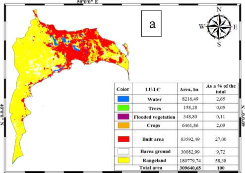
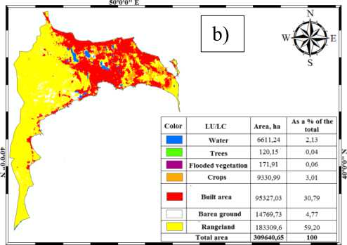
In the Absheron Peninsula and southeastern Gobustan, the process of soil degradation has progressed very rapidly against the backdrop of desertification. In many places, the humus horizon of the soil has completely disappeared, and the soil-forming rocks have come to the surface. Thus, desertification hotbeds have formed in many parts of the territory. The disappearance of the soil layer of the territory and the emergence of the parent rock to the surface are proceeding at the same speed. This process has been faster mainly in southeastern Gobustan, in the technogenic landscapes of the western and southeastern parts of Absheron, as well as in the oil production regions. In the XXI century, steps taken to improve the environment against the backdrop of the rapid expansion of the urban ecosystem in some areas of the Absheron Peninsula and southeastern Gobustan have significantly weakened the impact of the desertification process on the soil cover. In the thematic maps of land use/land cover compiled based on space images and sensor data, over the past decade, settlements have increased by 3%, cropland by 1%, and pastures and meadows by about 1%, while, on the contrary, badlands, wetlands, and aquatic ecosystems have decreased in the study region (fig. 2 / рис. 2).
50*0'0" Е
Fig. 2. Land use/land cover (LU/LC): a – 2014; b – 2024
Рис. 2. Использование земель и наземный покров (LU/LC): a – 2014 г.; b – 2024 г.
50*0'0" Е
Based on the analysis of the normalized vegetation index (NDVI) map of the last ten years, significant changes are observed in the study area. Thus, when comparing the data of 2014 with the data of 2024, a large difference can be seen (fig. 3 / рис. 3) This difference can also be seen from the soil surface moisture maps (fig. 4 / рис. 4) That is, compared to 2014, the average and good indicators in the 2024 classification decreased, while the very poor indicator increased by more than 7%.
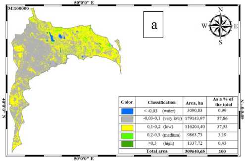
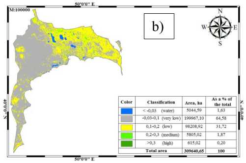
Fig. 3. The Normalized Difference Vegetation Index (NDVI): a – 2014; b – 2024
Рис. 3. Нормализованный относительный вегетационный индекс (NDVI): a – 2014 г.; b – 2024 г.
As can be seen from the soil moisture map, the moisture index for almost all categories was lower in 2024 compared to 2014. This difference is due to the difference in atmospheric precipitation during the vegetation period of those years, as well as the acceleration of the urbanization process in Absheron and southeastern Gobustan in the last ten years, the expansion of the construction sector, in short, the increase in anthropogenic impact.
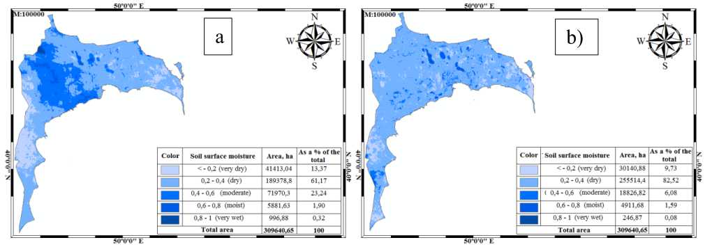
Fig. 4. Soil surface moisture: a – 2014; b – 2024
Рис. 4. Влагосодержание поверхностного слоя почвы: a – 2014 г.; b – 2024 г.
Under the long-term natural and anthropogenic impact on the Absheron Peninsula and southeastern Gobustan, the soil cover has been subjected to degradation and replaced by weathering products of the parent rock. The different speed of this process within the study area is due to the intensity of natural and anthropogenic processes. In the eastern part of the Absheron Peninsula, human economic activity in a positive direction has weakened the negative impact of natural processes on the territory, and on the contrary, intra-soil processes have begun to develop in a positive direction. In the west, southwest of Absheron and in southeastern Gobustan, anthropogenic activity in a negative direction has, on the contrary, increased the impact of negative natural processes on the soil cover. Thus, the processes of erosion, denudation, salinization have given the soils of the territory irreversible and recoverable properties. They determine the course of soil degradation. Thus, after completely losing organic matter, the soil gradually turns into geological sediments. The degree of soil degradation is assessed in accordance with the desertification classes.
When applying the assessment to the territory's soils, multi-year field research, laboratory analysis results, and comparative analysis of space images were used. At the same time, fundamental research works carried out in this direction in the Caspian coastal region were also taken into account (Babayev, Bayramov, 1965; Kharin, 1985; Meige, 1955; Nechaeva et al., 1978; Rozanov, 1986). Land degradation development in the Absheron Peninsula and southeastern Gobustan was carried out within the range of gray-brown soils (tabl. 1 / табл. 1).
The initial stage of degradation of gray-brown soils of the study area reflects the diagnostic signs of these soils. Thus, in terms of physical properties of the soil, its density is 0.9-1.1 g/cm2, which ensures normal infiltration both during artificial irrigation and during atmospheric precipitation.
The initial stage of degradation from the western to the eastern part of the Absheron Peninsula covers a wider area. Here, the expansion of olive and almond orchards in the form of large massifs has weakened the negative impact of natural exodynamic processes on the soil. As a result of positive human economic activity, the indicators of nutrients have undergone less transformation compared to the norm. In the “A” horizon of the soil, total humus varies between 1.3-1.5%, total nitrogen between 0.14-0.15%. At this stage, the upper horizon of the soil meets the criteria for weak salinization (0.03-0.1%).
The last month of the spring season and the lack of moisture in the summer season manifest themselves throughout the entire territory of the study region, and ephemeral plants completely dry out, only holophyte shrubs survive and tolerate these environmental conditions.
Table 1
Development stages of degradation of gray-brown soils of Absheron and southeastern Gobustan
Таблица 1
Этапы развития деградации серо-коричневых почв Апшерона и Юго-Восточного Гобустана
|
Indicators |
Degradation class |
|||
|
begining |
mild |
severe |
very severe |
|
|
Amount of humus in the «A» horizon, % |
1.3-1.5 |
1.0-1.2 |
0.5-0.9 |
<0.5 |
|
Salinity, salt content, % |
weakly saline |
moderately saline |
heavily saline |
saline |
|
Absorption capacity, in 100 g of soil, mg/eq |
18.5-21.5 |
17.5-20.0 |
15.0-17.5 |
17.0-18.0 |
|
Soil density, g/cm3 |
0.9-1.1 |
1.2-1.3 |
1.5-1.6 |
>1.6 |
|
pH (H 2 O) |
7.8-8.0 |
8.4-8.6 |
8.8-9.0 |
>9.0 |
|
Physical clay <0.01 mm, % |
48.0-52.5 |
50.0-56.5 |
62.5-68.5 |
76.5-78.0 |
|
Soil surface temperature, 2024, average for the growing season, °C |
19.4-23.1 |
23.2-24.9 |
26.6-28.5 |
31.4-35.2 |
|
Projective vegetation cover, % |
55-60 |
35-60 |
0-35 |
5-0 |
Changes in the morphological description of graybrown soils that have undergone moderate degradation are evident. Thus, the decrease in the amount of organic matter in these soils also affected their physical indicators. The density of the solid phase of the soil increased to 1.2-1.3 g/cm3, and the environmental reaction of the soil changed from weakly alkaline to alkaline. Signs of salinity and salinization are evident in the soil process. The type (Na₂SO₄), (NaCl), (CaSO₄), which is mainly sulfate and chloride in nature, was formed. The quantitative indicator corresponds to the degree of moderate salinization (0.1-0.3%).
The total humus content in the upper horizon of graybrown soils, which have been subjected to severe desertification, is below unity. It is difficult to determine the amount of nitrogen by chemical analysis. The density of the solid phase of the soil at this stage varies between 1.5-1.6 g/cm3. It has a heavy mechanical composition according to the physical clay index. The total salt content in the soil profile varies between 0.278-0.716%. Salinity corresponds to severe salinity (0.3-0.7%). Here, the environmental reaction of the soils in water solution is 8.88.0, and the project cover of highly alkalized plants is 035%.
Very severe degradation is localized in the study area, covering the low-lying areas of Absheron, oil-producing regions, and the Caspian coastal regions of southeastern Gobustan (fig. 5, 6 / рис. 5, 6). Here, the soil cover is almost completely devoid of organic matter, and total humus and total nitrogen were not observed in the upper horizon of some samples of the deposited soil sections.
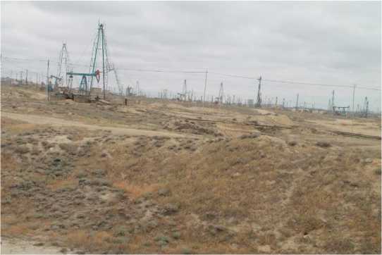
Fig. 5. Technogenically disturbed gray-brown soils of the Balakhani oil extraction area in Baku
Рис. 5. Техногенно нарушенные серо-коричневые почвы Балаханского нефтедобывающего района в Баку
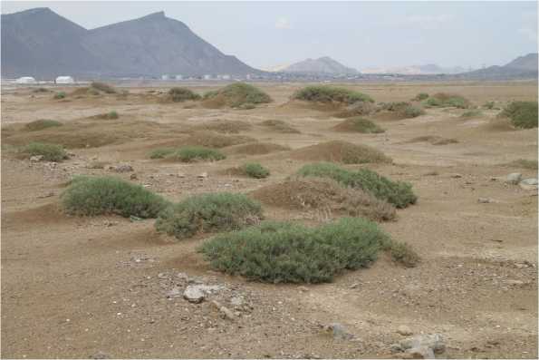
Fig. 6. Severe deflation process to underdeveloped gray-brown soils of southeastern Gobustan
Рис. 6. Сильная дефляция неразвитых серо-коричневых почв юго-восточного Гобустана
The soil density was > 1.6 g/cm3. The total salt content in the upper horizon of gray-brown soils, which were subjected to a very severe desertification process, varies between 1.564-2.0314%. According to the results of the full water gravity analysis of the moving dust fractions, the amount of salts was 0.5898-0.5647%. The environmental reaction in the water solution is highly alkaline.
The level fluctuations of the Caspian Sea also have a great influence on the course of the desertification process in the Absheron Peninsula and southeastern Gobustan. As a result of the decrease in sea level, the aquatic ecosystem has decreased by 0.52% of the total area in the last decade. The deflation process characteristic of the area has caused the destruction of the upper layer of soils by spreading mobile fractions around, accelerating the salinity process in the surrounding areas.
Conclusion
-
1. The direction of the desertification process is justified: in the oil production regions of the western part of the Absheron Peninsula and in the natural landscapes of
-
2. Human economic activity has weakened the impact of desertification on soils in a positive direction and created conditions for the development of the soil process in a positive dynamic. In the eastern part of the Absheron Peninsula, gray-brown soils under almond and olive groves are developing in a positive dynamic.
-
3. Regional and general characteristics of desertification of the lands of Absheron and southeastern Gobustan: the periodic nature of the migration and transformation of substances, which includes the loss of the biologically active layer of soils, and the emergence of soilforming rocks to the surface.
southeastern Gobustan, the increase in the impact of the eolian process on the soil cover as a result of the increase in anthropogenic impact; deflation as a result of the fluctuation of the Caspian Sea level, exposing the surrounding soil cover to salinity and salinization; dehumification of nutrients against the background of temperature and humidity deficiency, deterioration of the physical properties of soils. Overall, these processes have created hotbeds of desertification in the area.
Funding
The article was prepared in connection with the scientific report entitled «Desertification of the lands of Absheron Peninsula and South-East Gobustan and development of complex measures to combat it» (2024-2026), which was included in the work of the Institute of Geography PLE of the Ministry of Science and Education of the Republic of Azerbaijan.
Финансирование
Статья подготовлена в связи с научным докладом «Опустынивание земель Апшеронского полуострова и ЮгоВосточного Гобустана и разработка комплексных мер по борьбе с ним» (2024–2026 гг.), который был включен в работу Института географии ПЮЛ Министерства науки и образования Азербайджанской Республики.
Conflicts of interest
The author declares no conflicts of interest.
