Hydrological Variability and Climate Change Impacts in the Kura River Basin: Trends, Extremes, and Management Implications

Author: Ramazanly Z.
Journal: Бюллетень науки и практики @bulletennauki
Section: Естественные науки
Article in issue: 1 т.12, 2026.
Free access
This study was conducted to assess the impacts of hydrological variability and climate change on river discharge within the Kura River basin. The analysis indicates that both annual and seasonal flow regimes have undergone substantial alterations over recent decades, driven by rising air temperatures, uneven spatial - temporal distribution of precipitation, and reductions in snowpack. These changes have intensified the frequency and magnitude of hydrometeorological extremes-particularly floods and droughts - thereby increasing the complexity of forecasting and water-resource planning across the basin. The methodological framework integrates the Mann-Kendall trend test, Sen’s slope estimator, and AutoRegressive Integrated Moving Average (ARIMA) time-series modelling to detect long-term tendencies and quantify variability in streamflow dynamics. The combined application of these statistical tools enables a robust evaluation of monotonic trends, directional changes, and predictive behavior of discharge under changing climatic conditions. The findings highlight that adaptive water management, enhanced regional monitoring, and ecosystem-based approaches represent essential strategies for improving the sustainability and resilience of water-resource governance in the Kura River basin. Strengthening these measures will contribute to evidence-based decision-making and more effective responses to the growing challenges associated with climate-induced hydrological shifts.
Kura river, hydrological variability, climate change, extreme floods, water resources
Short address: https://sciup.org/14135573
IDR: 14135573 | UDC: 551.48 | DOI: 10.33619/2414-2948/122/08
Гидрологическая изменчивость и последствия изменения климата в бассейне реки Куры: тенденции, экстремальные явления и последствия для управления
Выполнена оценка влияния гидрологической изменчивости и климатических изменений на речной сток в бассейне реки Куры. Результаты анализа показывают, что как годовой, так и сезонный режим стока претерпели значительные изменения за последние десятилетия, что связано с повышением температуры воздуха, неравномерным пространственно-временным распределением осадков и сокращением снежного покрова. Эти гидроклиматические преобразования привели к усилению частоты и интенсивности экстремальных гидрометеорологических явлений, прежде всего, - наводнений и засух - что усложнило задачи гидрологического прогнозирования и управления водными ресурсами в регионе. Методологический подход основан на интегрированном применении теста тренда Манна-Кендалла, оценки уклона по Сену и моделирования временных рядов AutoRegressive Integrated Moving Average (ARIMA), что позволяет выявлять долговременные тенденции и количественно оценивать изменчивость гидрологических процессов. Совместное использование данных методов обеспечивает надежную основу для выявления монотонных трендов, анализа направленных изменений и прогнозирования динамики стока в условиях изменяющегося климата. Полученные результаты подчеркивают необходимость внедрения адаптивного управления водными ресурсами, усиления регионального гидрометеорологического мониторинга и применения экосистемного подхода. Эти меры являются ключевыми для повышения устойчивости, надежности и научной обоснованности управления водными ресурсами в бассейне реки Куры в условиях усиливающихся климатически обусловленных гидрологических изменений.
Text of the scientific article Hydrological Variability and Climate Change Impacts in the Kura River Basin: Trends, Extremes, and Management Implications
Бюллетень науки и практики / Bulletin of Science and Practice
UDC 551.48
The Kura River, as the largest river system in the South Caucasus, plays a strategic role in shaping regional water resources, supporting agricultural water supply, and maintaining ecological stability. The basin’s complex topography and climatic diversity contribute to pronounced spatial and temporal variability in river discharge. Over recent decades, global and regional climate variability – manifested through rising air temperatures, increasingly uneven precipitation patterns, and the intensification of extreme hydrological events – has significantly modified the hydrological regime of the Kura River.
International and regional assessments indicate that the mean annual temperature in the South Caucasus has risen by approximately 0.3–0.5°C in recent decades, while precipitation has exhibited increasing seasonal asymmetry [3, 7].
These hydro-climatic shifts have resulted in both reductions in annual and seasonal discharge and an expansion of variability amplitudes within the Kura River basin. Consequently, uncertainty in water-resource management has increased, creating a growing need for more advanced hydrological forecasting methodologies.The objective of this study is to provide a multidimensional assessment of hydrological variability in the Kura river basin by integrating the Mann-Kendall trend test [9],
Sen’s slope estimator [10], and ARIMA time-series modelling [1] to detect long-term changes in discharge dynamics. Mathematically, the Sen slope estimator is defined as:Q = median(— X‘), i < j-i j. Here, Xi and xj represent the observed discharge values in corresponding years. The Mann-Kendall test evaluates the statistical significance of monotonic trends using the Z-statistic and associated p-values, allowing for the identification of increasing or decreasing tendencies within the flow series. For hydrological time-series forecasting, ARIMA models account for autoregressive (AR), differencing (I), and moving-average (MA) components simultaneously, enabling comprehensive representation of discharge dynamics under non-stationary conditions [1].
The general form of the ARIMA model is expressed as: ф(В)(1 — B)dXt = 0(B)st.
Here, φ(B) is the AR operator, θ(B) is the MA operator, and d denotes the order of differencing. The integrated application of these statistical and stochastic approaches provides a robust framework for accurately assessing hydrological variability and supporting scientifically grounded decisionmaking in water-resource management across the Kura River basin.
Materials and Methods
This study is based on a multicomponent dataset covering the period from 2017 to 2024, aimed at quantitatively assessing hydrometeorological variability within the Kura River basin. The analysis focuses on temporal changes in river discharge, seasonal fluctuations, and the statistical evaluation of long-term trends. The methodological framework integrates trend-analysis techniques (the Mann-
Kendall test [9] and Sen’s slope estimator [10]), time-series modelling (ARIMA) [1], and a comprehensive suite of mathematical-statistical procedures.
Data sources: The datasets used in the research encompass the following core components:
Hydrological data (2017–2024): daily and monthly mean river discharge (m³/s) recorded at the Mingachevir, Hacigabul, and Neftchala hydrological stations along the Kura River.
Meteorological data: precipitation (mm), mean air temperature (°C), maximum and minimum temperature, and evapotranspiration indices.
Supplementary data: basin-scale landscape characteristics, land-cover information, and indicators of anthropogenic influence, including irrigation areas, water abstraction rates, and reservoir regulation effects.
Data pre-processing: During the preliminary data-processing stage, the datasets were evaluated for homogeneity, missing values were corrected using standard gap-filling techniques, and aggregation procedures (daily-to-monthly and monthly-to-seasonal scales) were applied. These steps ensured the consistency and reliability of the hydrometeorological time series prior to statistical and modelling analyses.
Research findings
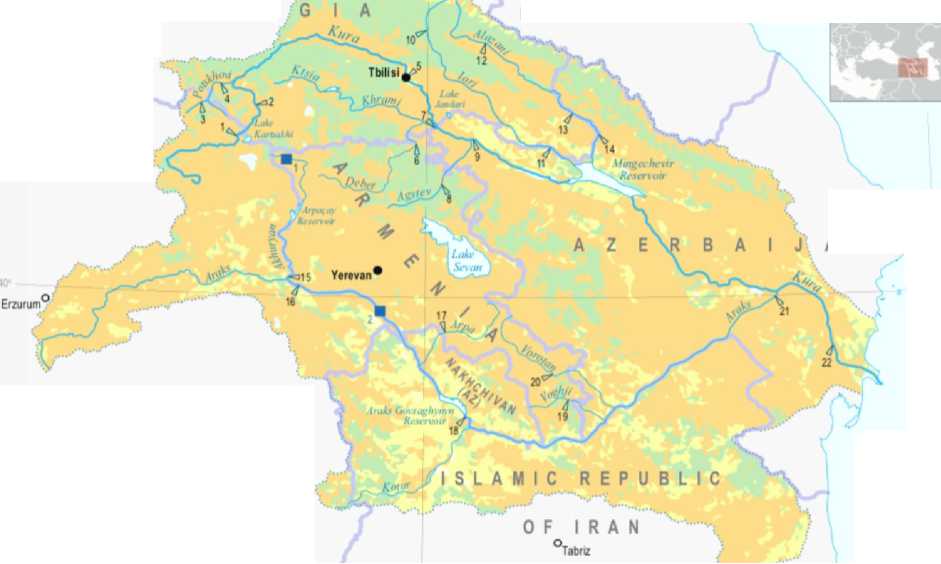
The Kura River basin – also referred to in some sources as the Kura-Araz basin – is one of the most significant transboundary hydrological systems in the South Caucasus and Western Asia. Geographically, the basin encompasses the territories of four core regional states – Azerbaijan, Georgia, Armenia, and Türkiye – along with a portion of the Islamic Republic of Iran. According to various hydrological assessments, the total basin area is reported to range between 188,072 and 190,110 km², highlighting its strategic importance for water-resource distribution, management, and transboundary water governance across the region [2, 3, 8].
Available data indicate that approximately 65% of the basin area lies within the South Caucasus countries. Within this distribution, Azerbaijan accounts for 31.5%, Georgia for 18.2%, and Armenia for 15% of the total basin area. The remaining portion includes 19.5% located within Iran and 15.1% within northeastern and eastern Türkiye. These proportions underscore the critical socio-economic, ecological, and hydrometeorological significance of the Kura River basin for the countries of the region [7, 8].
From a geographical standpoint, the basin spans diverse orographic zones of the Caucasus mountain system, including high-mountainous terrains, mid-altitude plateaus, and lowland valley systems. The basin originates in the mountainous areas of northeastern Türkiye, extends across central and eastern Georgia, and covers the entirety of Armenia. Furthermore, the northwestern part of Iran and more than half the territory of Azerbaijan fall within the hydrological boundaries of the basin. Such a broad spatial domain results in pronounced spatial and temporal variability in hydrological processes, necessitating multilayered and institutionally coordinated approaches to water-resource management. The transboundary nature and geographic complexity of the Kura River basin require a specialized analytical framework for assessing climate-related risks, anthropogenic pressures on water resources, and ecosystem resilience. These characteristics position the basin as one of the most critical areas in the South Caucasus in terms of water policy, hydrological research, and environmental security (Figure).
Climatic factors. The climate of the Kura River basin is characterized by high spatial heterogeneity, ranging from subtropical lowlands to cold mountainous zones, which exerts a strong influence on hydrological processes. While the majority of the basin falls within semi-arid and dry subtropical zones, the high-altitude regions of the Greater and Lesser Caucasus Mountains exhibit cold and humid climatic conditions. These variations critically determine the sources of river discharge, seasonal flow variability, and the mechanisms of water-resource formation [2, 7].
RUSSIAN
В LA СК
SEA
G E 0 R
FEDERATION
A
CASPIAN
SEA
TURKEY
25 50 75 tOC
■Ramsar Sites
1 We lands of Javakheti Regen Lake Arp
2 Ararat Valey and Araks River Flood -plain marches in the Araks River Valey and le ih-ponds
Figure. The Kura river basin [2]
N •
Baku
Mean annual temperatures range from 12–15°C in the lowland plains to below –2°C in the high mountainous regions. Long-term trend analyses of air temperature indicate a pronounced warming tendency, particularly during spring and summer months, which contributes to increased evapotranspiration and potential water loss. Annual precipitation exhibits substantial spatial variability, ranging from 200 mm to 1700 mm, with maximum rainfall occurring on the southern slopes of the Greater Caucasus and minimum precipitation observed in the Kura-Araz lowlands [3].
The uneven distribution of precipitation, coupled with snowmelt during spring and summer, plays a decisive role in shaping river discharge. Snowpack intensity and persistence in mountainous areas are key regulatory factors for the basin’s annual hydrological regime. In recent decades, decreases in both snow depth and duration have been observed, a trend that has been attributed to climate change impacts. Evaporation and aridity indices (including AI and PET indicators) suggest that a large portion of the basin is prone to water scarcity, and this vulnerability is further exacerbated under conditions of ongoing climate variability [7, 8].
Hydrological processes. The hydrological system of the Kura River basin is shaped by the complex interactions of multiple processes. River discharge is primarily influenced by both snowmelt and precipitation, exhibiting pronounced seasonal variability. In mountainous regions, snowmelt during spring and summer contributes significantly to streamflow, whereas in lowland areas, discharge is predominantly rainfall-driven, peaking during autumn and winter. This dual source of water results in the formation of two primary peak periods in the annual hydrograph of the Kura River [3, 8].
The structure of the river network also exerts a substantial influence on the hydrological regime. Major tributaries – including the Alazani, Iori, Tartar, Qanikh, Araz, and others – play a critical role in shaping the basin’s flow dynamics. Seasonal variability in discharge and the basin’s complex topography constitute key challenges for effective water-resource management [8].
Within the hydrometeorological context, both surface runoff and groundwater recharge are essential components. In recent years, short-duration, high-intensity precipitation events in high-altitude zones have led to an increased frequency and magnitude of flash floods. Enhanced convective activity and atmospheric instability have further contributed to the occurrence of extreme discharge events [3, 7].
Conversely, hydrological droughts have emerged as a major concern for the basin. Analyses using the Standardized Precipitation Index (SPI) and Standardized Precipitation Evapotranspiration Index (SPEI) indicate that both meteorological and hydrological drought intensities have increased, with river discharge in some years observed to be 20–40% below long-term averages. These conditions not only amplify the natural variability of water resources but also pose significant threats to the resilience of economic and ecological systems [9, 10].
Overall, the hydrological processes in the Kura River basin are governed by the combined effects of climate, topography, geological structures, and anthropogenic activities. Recent changes in these processes underscore the need for adaptive and scientifically grounded approaches to waterresource management in the region [7, 8].
The impact of climate change on hydrological processes. Climate change has induced multifaceted and complex alterations in hydrological processes within the Kura river basin. Observed warming trends, spatially and temporally uneven precipitation, reductions in snow cover, and increased evapotranspiration have significantly influenced both annual and seasonal river discharge dynamics. Rising temperatures, particularly in high-altitude zones, have led to earlier snowmelt relative to previous years, reduced snow reserves, and shortened the spring – summer peak-flow period. These changes amplify interannual variability in river regimes and destabilize the timing of water-resource formation [7, 8].
Variability in precipitation is another critical driver of hydrological dynamics. While relative increases in rainfall have been observed during autumn and winter in recent decades, decreases in spring and summer precipitation have expanded periods of hydrological drought. This effect is especially pronounced in the southern and western parts of the basin, such as the Araz and Qanikh sub-basins. Consequently, the frequency and intensity of drought events have increased, and the number of years with below-average discharge has risen [3, 9].
Conversely, the intensification of convective activity and the rising frequency of extreme rainfall events have substantially elevated flood and flash-flood risks. These events, particularly in mountainous and piedmont areas, accelerate soil erosion, sediment transport, and channel morphological changes. Climate change also affects groundwater recharge patterns; prolonged dry periods reduce replenishment of aquifers, increasing the vulnerability of hydrogeological systems [8, 10].
Overall, climate change has impacted both the quantitative and qualitative aspects of hydrological processes in the Kura river basin, increasing risks to water-resource management and emphasizing the necessity for adaptive and evidence-based strategies [3, 7, 8].
Management and modeling. The intensification of climate variability has rendered waterresource management in the Kura river basin a complex, multi-parametric challenge. Increased hydrological variability, the accelerated occurrence of extreme events, and rising water demand necessitate the modernization of management strategies and the implementation of evidence-based decision-making mechanisms [7, 8].
One of the primary challenges in basin-scale water management is the transboundary nature of water resources. Coordination limitations and uneven data exchange among Georgia, Azerbaijan,
Armenia, Iran, and Türkiye complicate the effective regulation of river discharge. Under such conditions, expanding regional hydrological monitoring networks, applying unified data standards, and integrating real-time information systems are critical for enhancing management efficiency [3, 8].
Hydrometeorological modelling plays a pivotal role in planning water resources. Tools such as Autoregressive Integrated Moving Average (ARIMA), Seasonal AutoRegressive Integrated Moving Average (SARIMA), Hydrologic Engineering Center – Hydrologic Modeling System (HEC-HMS), Soil and Water Assessment Tool (SWAT), and other physically-based and statistical models are extensively used for short- and long-term river-flow forecasting. Accurate representation of meteorological variables at high spatial and temporal resolution, together with high-quality observational datasets, is essential for reliable model outputs. Integrated modelling approaches, incorporating climate projections under Coupled Model Intercomparison Project Phase 6 (CMIP6) frameworks and Representative Concentration Pathways/Shared Socioeconomic Pathways (RCP/SSP) scenarios, provide more precise assessments of expected hydrometeorological changes within the basin [1, 7, 8].
An adaptive management approach should serve as a cornerstone of water policy in the Kura river basin. Key components include monitoring long-term water-balance trends, managing extreme risks (floods and droughts), applying ecosystem-based management strategies, restoring water infrastructure, and mitigating anthropogenic pressures. Furthermore, strengthening mechanisms for equitable and sustainable transboundary water allocation is of strategic importance [9, 10].
In summary, under conditions of climate variability, effective management of the Kura river basin requires a comprehensive approach based on multi-level monitoring, advanced modelling, and regional cooperation. Implementing these strategies ensures water security, protects ecosystem integrity, and supports long-term sustainable development in the basin [3, 7, 8].
Mann-Kendall trend test. The Mann-Kendall test is employed to detect the presence of monotonic increasing or decreasing trends in time-series data. Being non-parametric, the test does not require assumptions regarding the underlying distribution of the dataset [6, 9].
The test statistic S is computed as:
n-1 n
Z £
i=1 j=i+1
sgn (x j -Xi)
here,
{ +1, X j — xi > 0
0, xj — xi = 0
—1, X j — X i < 0
The standardized test statistic Z – is then calculated as:
|
S ~1 ^Var(S) ’ Z - < 0, S+1 [ ^Var(S) ’ |
S>0 (3) S = 0) S <0 |
Here, Var (S)denotes the variance of the statistic. The p-value is derived from the normalized distribution of Z, and trends are considered statistically significant if p < 0.05 [6, 9].
Sen’s slope estimator. Sen’s method quantifies the magnitude of a monotonic trend, i.e., the annual rate of increase or decrease. The slope between every pair of observations is calculated as:
Q..= Ъ—l^i (4)
Q lj j-i ’ j > l
The overall trend Q -is defined as the median of all Q ij values:
Q = median(Q ij ) (5)
Q > 0 indicates an increasing trend. Q < 0 indicates a decreasing trend. I Q I reflects trend intensity. This method is robust against outliers and is widely applied in hydrology [6, 7, 9].
Time-series modelling (ARIMA). For short-term forecasting of river discharge, Autoregressive Integrated Moving Average (ARIMA) models were applied. The general form of the model is:
ARIMA(p,d,q) (6)
here, p = order of the autoregressive (AR) component, d = degree of differencing (integration), q = order of the moving average (MA) component [1, 8].
Model construction involves the following steps: Testing for stationarity (ADF test, differencing); Determination of pand qusing ACF and PACF plots; Maximum likelihood estimation of model parameters; Evaluation of forecast errors using RMSE, AIC, and BIC metrics.
ARIMA models provide high predictive accuracy for non-stationary flow series, particularly in river basins sensitive to climate variability [1, 8, 11].
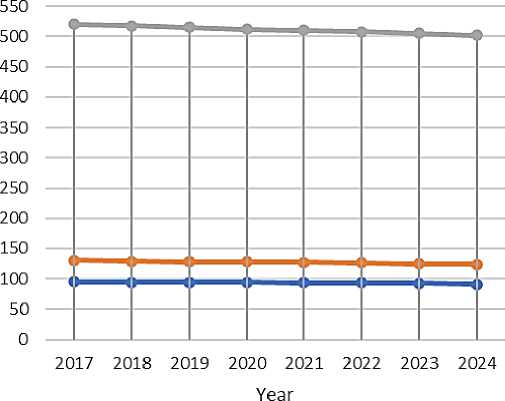
Annual and seasonal flow variability. The Kura river basin was analyzed for mean annual discharge over the period 20172024. At the Mingachevir station, located in the upper reaches of the Lower Kura, the highest mean annual discharge values were recorded (512 m³/s). At Hacıqabul and Neftchala stations, the corresponding mean annual discharges were 128 m³/s and 94 m³/s, respectively [8, 11].
Seasonal flow variability is primarily influenced by snowmelt and spring – summer precipitation. In the upper basin (Mingachevir), peak flows are observed during April – June, while in the lower reaches (Neftchala), flood peaks during the summer are less pronounced, and discharge reductions in autumn and winter appear relatively stable [8, 11].
AVERAGE ANNUAL FLOW AND TREND INDICATORS
Table
|
Station |
Mean annual discharge m³/sec |
Trend direction |
Sen slope m³/sec/year |
Significance p |
|
Mingachevir |
512 |
↓ |
-2.3 |
0.02 |
|
Hacıqabul |
128 |
↓ |
-0.7 |
0.05 |
|
Neftchala |
94 |
↓ |
-1.1 |
0.03 |
Trend analysis. Analysis using the Mann-Kendall test and Sen’s slope estimator indicates a decreasing trend in annual discharge in the middle and lower reaches of the basin. The annual decrease rates were estimated as -2.3 m³/s per year at Mingachevir, -0.7 m³/s per year at Hacıqabul, and -1.1 m³/s per year at Neftchala. The trends were statistically significant at p < 0.05, confirming that these variations are not random. These findings reflect the long-term decline in mean and lower reach discharges resulting from climate variability and anthropogenic impacts [6, 8-10].
Extreme events: floods and high-flow statistics. During 2017-2024, flood and high-flow events were recorded throughout the Kura River Basin. The majority of extreme events occurred in spring and summer, associated with snowmelt and intense convective precipitation.
The return period of extreme discharge events was estimated at 10-12 years for Mingachevir, and 5-8 years for Hacıqabul and Neftchala [5, 8].
The intensity of floods and high-flow events increased by 20-25% over the past five years.
These statistics highlight the impact of climate variability and anthropogenic pressures on hydromorphological processes in the basin and underscore the necessity for adaptive and evidencebased water-resource management strategies [8, 11, 12].
E
о
—^—Neftchala
^^Hajigabul
^^Mingachevir
Figure 2. Mean annual discharge at the lower reaches of the Kura river (m³/s) [8].
Conclusion
This study systematically and scientifically assessed the sensitivity of hydrological processes in the Kura river basin to climate variability and climate change. Analyses indicate that both annual and seasonal flow regimes have undergone significant alterations over recent decades. Increases in air temperature, uneven spatial–temporal distribution of precipitation, reductions in snow cover, and intensified evaporation have altered both the quantitative and qualitative parameters of hydrological processes, increasing the variability of river discharge across seasons and in long-term regimes. Extreme hydrometeorological events – particularly floods and droughts – have intensified in terms of both frequency and magnitude, thereby elevating risks to hydrological security and water-resource management [3, 7, 8, 11].
Under these conditions, the effectiveness of water management is directly linked to the accuracy of forecasting models and the development of hydrological monitoring systems. The application of ARIMA, SARIMA, SWAT, and integrated physical-statistical models supports both short-term and long-term flow forecasting and enhances preparedness for extreme events [1, 4, 6, 8]. Adaptive management approaches, ecosystem-based methods, and strengthened regional monitoring emerge as essential strategies for the sustainable governance of water resources within the Kura river basin [5, 8, 12].
Consequently, the development and implementation of effective adaptation strategies to climate change ensure the resilience of hydrological systems, contribute to the conservation of regional ecosystems, and enhance water security. These approaches not only reinforce evidence-based decision-making but also play a strategic role in the sustainable management of transboundary water resources [7, 8, 12].
