
Excavations of a Neolithic Dwelling at Pod Lipami, Primorye, in 1976
Journal: Archaeology, Ethnology & Anthropology of Eurasia @journal-aeae-en
Section: Paleoenvironment, the stone age
Article in issue: 4 т.52, 2024.
Free access
Long-term archaeological excavations have been carried out at a large group of Late Neolithic (Zaisanovka culture) settlements on the left bank of the lower Partizanskaya River in southern Primorye, mostly dating to early 2nd millennium BC and somewhat earlier. Remains of half-dugout dwellings were unearthed. Many sites, including Sopka Bulochka, Sopka Bolshaya, and Pereval, have been previously published. The only exception is Pod Lipami, a site consisting of a single dwelling, on which this study focuses. Its sub-rectangular foundation, ~46 m2 in area, had been dug into the slope of the hill, forming a terrace-like platform. The wattle dwelling had a hearth in the center. Numerous stone agricultural tools were found—hoes, querns, grinders, pestles, etc. Other lithics are adzes, scraping, cutting, and grinding tools, including those made of obsidian. Ceramics are represented by shards and larger fragments of crushed handmade flatbottomed and potand vase-like vessels, mostly decorated with carved vertical zigzags, curvilinear figures, and spirals, which are more common in the Neolithic of the Lower Amur. Small as it is, the site with its radiocarbon dates extends our knowledge of the Zaisanovka culture and of its creators, sedentary farmers.
Similar articles in the section Prehistory. Prehistoric remains, artefacts, antiquities
Short address: https://sciup.org/145147476
IDS: 145147476 | DOI: 10.17746/1563-0110.2024.52.4.098-105
Text of the scientific article Excavations of a Neolithic Dwelling at Pod Lipami, Primorye, in 1976
The search for and excavations of the prehistoric sites were carried out discontinuously over ten field seasons of varying lengths by the teams of the Institute of History, Philology and Philosophy of the Siberian Branch of the USSR Academy of Sciences, and later of the Institute of Archaeology and Ethnography SB RAS in southern Primorye, during the period from the mid-1960s up to the early 2000s. The greatest attention was paid to elevated areas in the valley of the Lower Partizanskaya (formerly Suchan) River, 3–8 km from the village of Vladimiro-Aleksandrovskoye in the Partizansky District, mainly in the direction to the city of Nakhodka. A total of six archaeological sites were discovered, at four of which large-scale excavations were carried out.
A settlement site on the Pereval hill, near the village of Vladimiro-Aleksandrovskoye, was studied first. A total of six dwellings attributed to the Zaisanovka Neolithic culture and dated to the second half of the 3rd to early 2nd millennium BC were studied (three of them, only partially). The remains of half-dugout dwellings located on the site of a previously destroyed settlement apparently belonged to the same culture. It was determined that some part of the Pereval hill was earlier inhabited by the bearers of the Rudnya Middle Neolithic culture, with ceramics ornamented with the “Amur plait” motif. The even earlier assemblages of artifacts were abandoned here on the turn of the Pleistocene and Holocene, which is supported by
two radiocarbon dates—11,150 ± 100 (LE-1565) and 10,100 ± 100 (LE-1566) BP.
The excavated dwellings contained typical ledges along the walls, a kind of “beds”, common in the Neolithic residential structures in the southern part of the Russian Far East, and a hearth in the center. There were large collections of ceramics (including intact potlike vessels) and various lithic tools: querns, grinders, hoes, pestles, polished adzes, retouched and polished arrowheads, knives-bifaces, borers, fishing sinkers, and others. Particularly noteworthy are the series of tools associated with the initial stage of agriculture in Primorye (Okladnikov, Medvedev, 1995; Medvedev, 2000; Medvedev, Kononenko, 2002).
The second multi-layered site was located on the Bulochka hill, 7 km northwest of Vladimiro-Aleksandrovskoye. This is the most well-studied site in the region, containing the remains of various periods and cultures. A total of 24 dwellings was unearthed here, 21 of which dated back to the Early Iron Age (the Krounovka culture and Poltse cultural community), and three other dwellings to the Late Neolithic Zaisanovka culture. Some groups of artifacts indicate that prior to Zaisanovka people Bulochka was inhabited by those of the Boisman Middle Neolithic culture; though, no traces of Boisman dwelling structures were found. The Zaisanovka people were the first to construct artificial terraces and build dwellings on the Bulochka hill. Sopka Bulochka is one of the key ancient sites in Primorye; it was described in many publications (see, e.g., (Okladnikov, Glinsky, Medvedev, 1972; Derevianko et al., 2005; Derevianko, Medvedev, 2008; Medvedev, Filatova, 2011; and others)).
The third settlement belonging to the Zaisanovka culture was discovered on the dome-shaped summit of a hill we called Sopka Bolshaya (Medvezhya), near the Lebyazhya lagoon close to the Bulochka hill, approximately 7 km southwest of Vladimiro-Aleksandrovskoye. The settlement consisted of no more than six dwellings; the remains of the dwellings in the form of round, very vague depressions 3–8 m in diameter were visible on the surface prior to excavations; these were located compactly at a distance of 0.5–2.0 m from one another. Research at the site was conducted over three field seasons (1970, 1971, and 1976); four dwellings were excavated over a total area of 243 m2. All of them were rectangular in plan view (with rounded corners), with shallow foundation pits showing no traces of post holes nor hearths. The most numerous were stone tools associated with agriculture: hoes, grinders, querns, and pestles. Adzes, end-scrapers, arrowheads, and other tools were also found. Pottery was represented by solitary sherds, as well as pot-like and vase-like vessels crushed by soil; the vessels were decorated with applique cordons close to the rim edge and a pattern of oblique lines and vertical zigzag over the body and shoulders. The settlement was defined as a seasonal, short-term camp of farmers. It could have been inhabited in the early 2nd millennium BC (Medvedev, 2015).
The other settlement sites of U Dorogi and Vosmoi Kilometr were significantly destroyed and were only partially explored through cleaning and trial excavation. The former was located at the foot of the southeastern slope of the Bolshaya hill, on a low terrace-like platform facing the nearby Lebyazhya lagoon. Remains of two dwellings of the Zaisanovka people were uncovered. One of these dwellings yielded ceramics decorated with various vertical zigzags, and two ceramic spindle whorls of biconical and disc-like shapes; another dwelling, ceramics with carved patterns, a vessel fragment bearing a spiral pattern, hoes made of chert, and obsidian and flint flakes. The Vosmoi Kilometr settlement was located on the top of a 10–15-meter high hill next to the road, 8 km from Vladimiro-Aleksandrovskoye in the direction of Vrangel Bay. The site was attributed to the Neolithic, mainly to its middle and late stages.
The above brief review of the archaeological sites shows that during the Neolithic small groups of people established several long-term settlements on a relatively small area of the fertile valley of the Partizanskaya River, not far from its estuary. The main or one of the main occupations of the population was agriculture. The archaeological materials from almost all the above sites have been published. However, the results of the excavations of the Pod Lipami site-dwelling were not described, although the site is often mentioned in the literature. This paper aims to fill the gap in the corpus of the Primorye antiquities.
Results of the Pod Lipami excavation campaign
The site under study, representing an isolated dwelling, a sort of ancient farmstead, was located in the vicinity to the Lebyazhya lagoon in the Partizansky District, Primorye, and excavated in October 1976*. The vast lagoon is located between the widely known Brat and Sestra hills, 6–7 km southwest of Vladimiro-Aleksandrovskoye. The Manankina River flows into the lagoon; the Bulochka hill rises to the northwest of the lagoon, and the Bolshaya (Medvezhya) hill stands further upstream. An unnamed hill, which we called
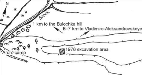
Fig. 2. Map of the Pod Lipami hill and its surroundings (after (Okladnikov, 1976) in a modern edition).
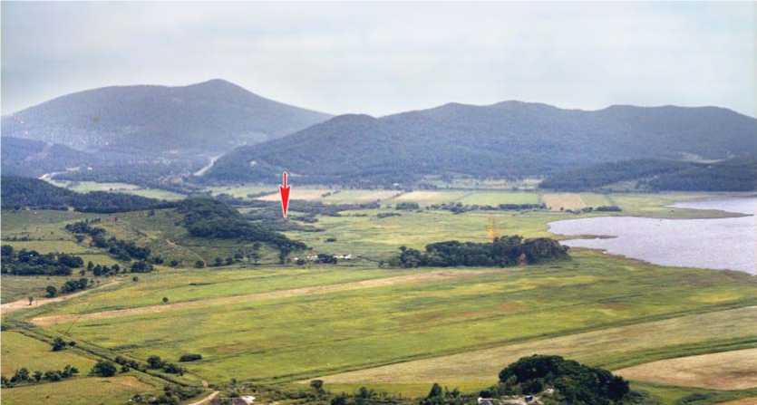
Fig. 1. Location of the Pod Lipami hill (indicated by the arrow; the Bulochka hill and the adjacent Lebyazhya lagoon are to the right).
Pod Lipami, is situated 0.5 km from the Bolshaya (Medvezhya), over a small stream in a fairly wide valley. The data provided herein have been collected by V.E. Medvedev in the course of analysis of the Pod Lipami artifact assemblage deposited at the Institute of Archaeology and Ethnography SB RAS and cited from the A.P. Okladnikov’s field report (1976) and his diary.
The dwelling was located at an altitude of about 35 m on the southern slope of a long promontory at the fork of the Manankina River and an unnamed stream (Fig. 1, 2). This slope is steep (about 60°), densely overgrown with hazel and small oak trees; the opposite side of the valley is more gentle (about 30°). Among the small oak trees, two very old linden trees survived (hence the name of the hill). A shallow depression, about 5–6 m in diameter and not exceeding 30–35 cm deep from the surface of the hill, was noted on the soil covering the dwelling remains. The excavation trench of 9 × 7 m with two mutually perpendicular edges oriented to the cardinal points (Fig. 3, a) was established. The edges remained intact until the end of the work, and served as reference profiles. The stratigraphic sequence was the same all over the edges (Fig. 3, b, c). On top there was a thin layer of dark to intensely black turf not exceeding 15 cm thick. Upon removing this layer in sq. Д3, Д4, a small hearth of irregularly rounded shape, 30 cm in diameter, was found. The hearth contained an ash mass at the bottom, overlain with a black carbonaceous mass. A fairly large unprocessed stone was uncovered at a depth of 20 cm from the soil surface. The total area of the dwelling pit was about 46 m2. The filling consisted of yellow-brown loam with an admixture of coarse small rubble. The thickness of foundation pit sediments in the center reached 40 cm. The underlying virgin land was lighter colored loam saturated with abundant rubble of the above type.
The general shape of the dwelling is rectangular with rounded corners in plan view. In the southern part of the pit, adjacent to the highest part of the hill, there is a steep ledge of the dwelling wall. Its maximum height is 85– 90 cm (without additional 10–15 cm of the turf layer). The heights of the pit walls gradually decrease to the northern part of the dwelling. The contours of the dwelling pit in the northern part are hardly traceable, as if the walls tailed. It seems that the pit digging went deeper into the hill in the southern part (upland), and only leveled the surface of the hill in the northern part. The floor of the dwelling is generally horizontal, but not even, with small depressions.
A large, flat, elongated ovoid axe made of dark-gray chert, broken crosswise into four parts, was found on the border between sq. Д1 and Д2, at a depth of 20 cm (Fig. 4, 2 ). Also, small fragments of a clay vessel
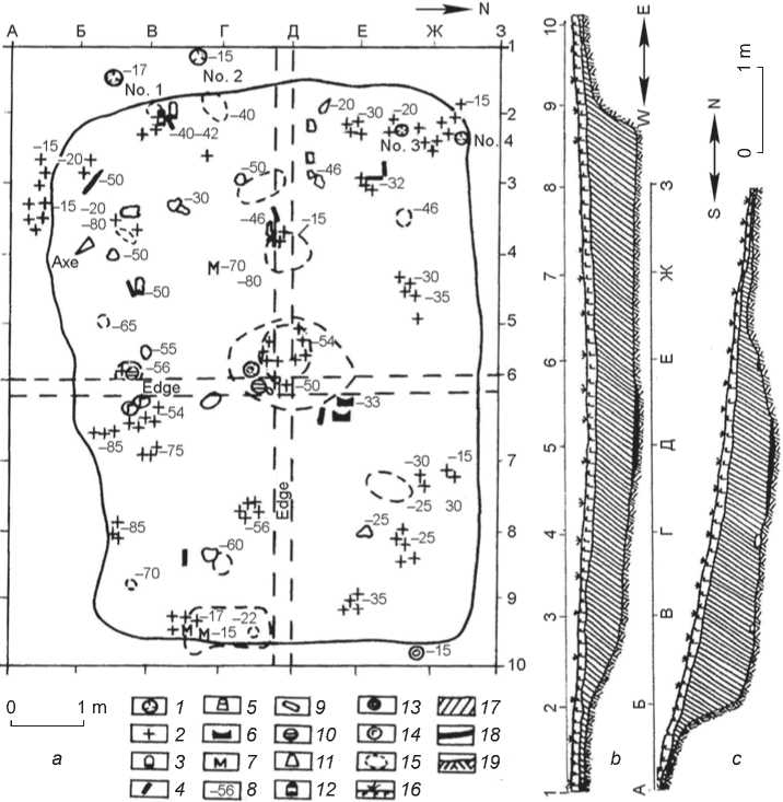
Fig. 3. Map of the dwelling ( a ) and profiles along the lines Д ( b ) and 6 ( c ).
1 – pit; 2 – ceramics; 3 – end-scraper; 4 – flake; 5 – adze blank; 6 – quern; 7 – hoe; 8 – depth of the find occurrence; 9 – stone; 10 – grinding tool; 11 – adze; 12 – obsidian end-scraper; 13 – pressure tool; 14 – grinding pebble; 15 – carbon stain;
16 – topsoil; 17 – yellowish-brown loam; 18 – carbonaceous layer; 19 – virgin land.
with a carved linear ornament were recovered here. In sq. Д2, at a depth of 30 cm, two fragments of rock were discovered close to one another; originally, these were likely located on the roof of the dwelling or at its edge. In the same square, the bottom of a clay container was found. At a distance of 20 cm from it, a 15-cm-high crushed thinwalled clay vase-like vessel with a flat bottom lay on its side. In neighboring squares E2, 3, fragments of a large thick-walled vessel ornamented with a carved vertical zigzag were found. Remains of another crushed vessel were recovered from a layer of 15–20 to 30 cm deep in squares Д1, 2–Ж1, 2.
A black obsidian flake retouched over one of the edges, which apparently served as a cutting tool, and a fragment of the thick bottom of a clay vessel were found at a depth of about 40–42 cm in sq. В2. These items were recovered from a dark carbonaceous layer near the western wall of the dwelling. The layer also contained small pieces of charcoal and burnt bark of black birch in the form of thin charred pieces.
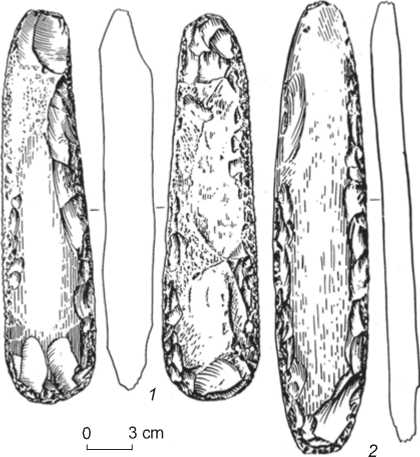
Fig. 4. Stone axes.
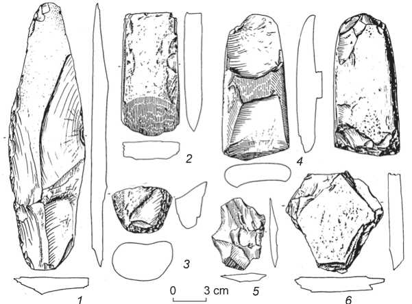
Fig. 5. Stone tools.
1 – tool blank; 2 , 4 – adzes; 3 – chipped pebble; 5 – flake; 6 – tablet.
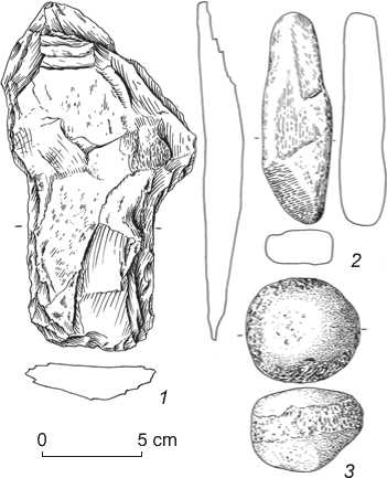
Fig. 6. Hoe blank ( 1 ), polishing pebble ( 2 ), and pressure tool ( 3 ).
At a depth of 50 cm, in sq. В3, a large coarse fragment of chert was found; two more of the same kind were recorded nearby. These stones were likely located on the edge of the pit, from which they rolled down. In the same square, at a depth of 80 cm, a robust polished axe, 26 cm
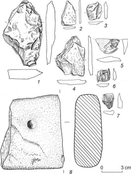
Fig. 7. Spalls from tools and flakes ( 1–7 ), fragment of quern with a hole ( 8 ).
long, oval in cross-section, with traces of microflaking on the working edge (Fig. 4, 1 ) was found lying in a horizontal position. It was located in a small depression in the dwelling’s wall. At the border between squares Б2 and Б3, there was a rough lamellar blank of a knife or blade made of dark chert, 24.5 cm long and 7.2 cm wide (Fig. 5, 1 ); in square В4, a blank of a shouldered hoe made of the same rock (Fig. 6, 1 ). These artifacts were located at a depth of 70–80 cm.
On the border between squares B1 and B2, small obsidian flakes and a jet-black point lay close to one another on the floor of the dwelling. In sq. Ж1, 2, Е2, 3, fragments of crushed clay vessels with cornice-shaped rims and an ornament of carved vertical zigzags were discovered.
In the center of the dwelling (sq. Г4, 5–Д4, 5), at a depth of 50 cm, there was a hearth. It was located at the intersection of the reference profile walls; originally, it was the deepest point in the depression traced on the surface before the excavations. The rounded hearth pit was 1.4 m in diameter and 15 cm deep from the dwelling floor level. Red-burnt stone fragments were found at the pit bottom, partially overlain with a thin carbonaceous layer of intensely black color. Fragments of a vessel ornamented with carved curve lines were recovered from this layer in three small clusters. One of the fragments had four holes that obviously had been used for fastening the broken vessel. The hearth area yielded a broken adze (oval in cross-section), two large chert flakes, and two well-rounded small pebbles.
In sq. Д6, two fragments of a quern were found, which could also have been used as a “fire stone”, judging by the typical holes (Fig. 7, 8). A large fragment of a vessel with a cornice-shaped rim ornamented with vertical zigzag was found on the rocky floor of the dwelling in sq. Е7; fragments of another such vessel were noted in sq. Ж7. Fragments of vessels ornamented with curve lines (Fig. 8, 6, 7; 9, 3, 5, 7, 8) and pricked rows (Fig. 9, 6) were discovered in squares E7, 8. Ceramics were also found in sq. Г4, 5 (depth 50 cm), Г7 (depth 56 cm), and in other squares. In particular, in sq. А2, 3, Б6, 7, and В9, fragments of vessels with rim-cornices, ornamented with vertical zigzags, were discovered after the final cleaning of the dwelling’s floor and walls (see Fig. 8, 1–5; 9, 2). A shard with a “pearl” (punched node) pattern was also found (see Fig. 9, 4).
In addition to the above-listed lithic artifacts, the dwelling (on the floor and in the filling) contained adzes in sq. Г5 and Г3 (see Fig. 5, 2 , 4 ), chipped pebbles in sq. Б6 and Б8 (see Fig. 5 , 3 ), spalls from tools and flakes in sq. Д5 and Д6 (see Fig. 7, 1–7 ), and a pressure tool (see Fig. 6, 3 ). In sq. В9, there was a well-rounded pebble with depressions in the middle. A relatively large fragment of rock lay on the horizontal floor at the border between sq. Д7, 8 and Е7, 8.
The holes from posts supporting the roof were not clearly visible and survived only in the western part of the excavation area. Two such holes were in sq. Б1 and В1 near the dwelling; and two more, inside the dwelling, in its northwestern corner, at a distance of 1 m from one another. All the holes were round in plan view, 10– 15 cm in diameter, 15 cm deep, and were filled with loose humic soil.
Discussion
The Pod Lipami dwelling is an unusual settlement site with a single residential construction on the hill. At first glance, the site may seem unremarkable and insufficiently informative. However, the excavation findings are quite useful for expanding our knowledge on the economic activities of the inhabitants of southern Primorye in the Late Neolithic. The formerly derived data on their occupation of the tops of small hills surrounding the flat fertile valleys near the Razdolnaya River and other rivers and streams have been confirmed.
On the hills of Bulochka, Bolshaya, Pereval, and others, Zaisanovka people constructed their dwellings on the foundations deepened into the ground (in some places, sandstone rocky sediments). They arranged small pits or terrace-like platforms of a sub-rectangular shape on the slopes of the hills, with well-defined walls on the upland sides and the vague or absent walls on the foothill sides. Notably, not all the studied Zaisanovka sites in southern Primorye were long-term, i.e. with year-round habitation of people. The observed features suggested that the sites were used only during the periods of agricultural
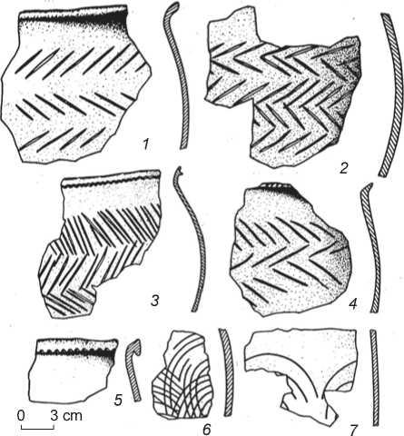
Fig. 8. Pottery.
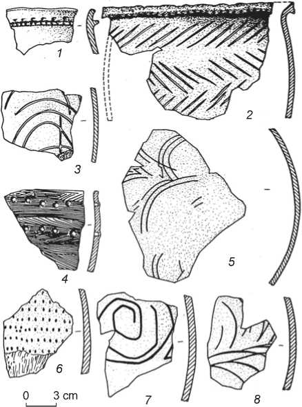
Fig. 9. Pottery.
activities. This explains the simple design of the dwellings. The foundation pits were quite shallow; no holes from posts supporting the roofs were identified. Residential structures appear to have been in the form of chums based on a wooden frame made of poles covered with birch bark, animal skins, and other materials. Another fundamentally important feature was the absence of any hearths therein. As for the Pod Lipami dwelling, it contained elements characteristic of a long-term residential structure: a deep underground foundation, traces of post holes, and a hearth established in a specially prepared pit.
The noted characteristics of the Pod Lipami dwelling suggest that agriculture played a significant role in the subsistence activities of its inhabitants; a large portion of their food products were most likely cereal seeds. Although no seed remains were found during the excavations, the set of tools associated with preparing the land for sowing, harvesting, and processing the crop (hoes, blade knives, querns, grinders, and pestles) points to agriculture as the main economic activity. Notably, all the above types of tools, including robust polished axes (see Fig. 4) used for uprooting and clearing land for sowing, show numerous dents and flake scars, i.e. usewear traces.
Scraping and cutting tools, grinding pebbles and tablets, and a pressure tool found all over the residential complex suggest stone working activities. Chert, granitoids, flint, obsidian, and fine-grained sandstone were the main raw materials used for the manufacture of tools. Woodworking tools include axes and well-prepared polished adzes, rectangular or ovoid in cross-section, with traces of repeated use in construction works, mostly outside the dwelling in the warm season.
The pottery recovered at the site is traditionally important for making more or less balanced judgments on the cultural affiliation of the residential complex attributed to the Zaisanovka culture. The available ceramics include parts of crushed vessels and clusters of scattered shards. In general, the excavations revealed a well-balanced set of stone and ceramic products that had accumulated over the time of the site habitation. In terms of quantity, the assemblage is not as great as is usually observed in the Neolithic dugout and half-dugout dwellings of the south of the Far East, especially Lower Amur. On the other hand, the site is remarkable for the absence of foreign cultural artifacts.
The recovered pottery remains are, almost exclusively, low pot-like, slightly narrowed at the bottom and widened at the top vessels, often with an appliquéd rim in the form of a cornice. The pottery is hand-made, with rough or smoothed surfaces; the paste is tempered with fine sand and grog. The Pod Lipami vessels are characterized by the main technological, morphological, and stylistic features typical for the Zaisanovka ceramics.
Most of the ornamented ceramics recovered from site bear various vertical and horizontal zigzag motifs made by incised lines or combing. Another ornamental motif—carved curvilinear figures and spirals—does not belong to the “typical” Zaisanovka ornamentation pattern, it is mostly characteristic of the Voznesenovskoye culture of the Lower Amur, and supports the hypothesis of the priority of contacts between these two fairly contemporaneous cultures.
In recent decades, the Zaisanovka culture, representing the terminal stage of the Neolithic in Primorye, has attracted considerable interest among archaeologists. New sites have been discovered; the origin, development, chronology of this culture, as well as the material and spiritual perceptions of its carriers, have been discussed. The data derived in the course of the Pod Lipami excavations provide significant additional information on the Zaisanovka culture. The radiocarbon analysis of charcoal pieces from the dwelling provided the following dates: 3915 ± 50 BP (SOAN-1530) and 3635 ± 30 BP (SOAN-1532), suggesting its attribution to the first half of the 2nd millennium BC. It is still unclear why this dwelling remained single and isolated, and whether it was built voluntarily or forced by situation. This issue is unlikely to be easily resolved.
Conclusions
The isolated Neolithic dwelling was excavated during the archaeological works on the Pod Lipami hill. This site represents a kind of a New Stone Age farm. It is probably the only one of its kind in the southern part of the Russian Far East.
The relatively few artifacts found in this Late Neolithic single-layer archaeological site of the Zaisanovka culture include shouldered hoes, querns, and vessels decorated with patterns of carved lines. Some vessels bear the motifs of characteristic zigzag lines, others curved lines, spirals, and arcs. The curvilinear pattern was a relatively new element in the Zaisanovka culture. In this regard, the ceramics with punched node “pearl” ornament, rare for Primorye, are noteworthy. The category of small tools includes obsidian items typical of the Neolithic of Primorye.
The site was defined as a farmer settlement, which conclusion was based on the recovered hoes, querns, and grinders. Furthermore, the dwelling belonged to a sedentary population, living permanently in one place. These people constructed houses with foundations deepened into the ground; and they manufactured clay flat-bottomed vessels. The derived radiocarbon dates provide the important information that extends our knowledge of the complicated issues of chronology of the Primorye Neolithic.
Acknowledgements
