Stone sculptures of Zhetysu and Saryarka: spatial patterns, iconography and the concept of a GIS register

Journal: Materials on Archaeology and History of the Ancient and Medieval Black Sea Region @maiask
Article in issue: 21, 2025.
Free access
The article is devoted to the scientific systematization and digital inventory of Turkic-period stone sculptures discovered in the Jetisu and Saryarka (Kazakhstan). It examines their landscape localization, as well as the iconographic and semantic characteristics of these monuments. The authors propose a methodological model for a unified digital registry, incorporating geographic coordinates, typology, dimensions, iconography, archaeological context, and the preservation of each object. A structured data scheme has been developed with fields for comprehensive documentation attributes, including: monument name, discoverer or expedition, administrative location (region, district), year of discovery, precise coordinates, sculpture dimensions, typology, iconographic elements (presence of vessels, weapons, ornaments, clothing elements), connections with other components of the memorial complex (enclosures, burial mounds, stone sculptures, balbals), chronology, and references to publications. This systematic approach allows data to be standardized, facilitating creation of cartographic visualizations and conducting a typological and chronological comparative analyses of the monuments. GIS modeling has revealed spatial patterns: the majority of sculptures are concentrated at the foot of mountains and in river valleys, and nearly all figures are oriented east ward. The proposed digital registry contributes to the preservation of cultural heritage and promotes interdisciplinary research. It can be integrated into national and international monument registries, employed for visualization (interactive maps, virtual museums) and support the development of conservation measures. This work is essential for the further Turkic era, the sacred geography of the region and the reconstruction of the social and religious practices of ancient Turkic communities.
Similar articles in the section Cultural remains of historical times
Short address: https://sciup.org/14135356
IDS: 14135356 | DOI: 10.53737/2713-2021.2025.83.51.001
Каменные изваяния Жетысу и Сарыарки: пространственные модели, иконография и концепция ГИС-реестра
Статья посвящена научной систематизации и цифровой инвентаризации каменных изваяний тюркского периода, найденных в регионах Жетысу и Сарыарка (Казахстан). Рассматриваются особенности их локализации в ландшафте, иконографические и семантические характеристики памятников. Авторы предлагают методологическую модель единого цифрового реестра, включающего географические координаты, типологию, размеры, иконографию, археологический контекст и состояние сохранности каждого объекта. Разработана структурированная схема данных с полями для комплексной фиксации атрибутов: название памятника, авторство или экспедиция открытия, административное расположение (область, район), год выявления, точные координаты, габариты изваяния, типология, иконографические элементы (наличие сосудов, оружия, украшений, элементов одежды), связь с другими компонентами мемориального комплекса (ограждения, курганы, каменные изваяния, балбалы), хронология и ссылки на публикации. Такое систематизированное представление данных позволяет привести их к единому формату, обеспечивая создание картографических визуализаций и проведение типологического и хронологического сравнительного анализа памятников. ГИС-моделирование выявило пространственные закономерности: большинство изваяний сосредоточено у подножий гор и в речных долинах, практически все фигуры ориентированы на восток. Предлагаемый цифровой реестр способствует сохранению культурного наследия и развитию междисциплинарных исследований. Он может быть интегрирован в национальные и международные регистры памятников, использован для визуализации (интерактивные карты, виртуальные музеи) и разработки охранных мер. Работа важна для дальнейшего изучения тюркской эпохи, сакральной географии региона и формирования представлений о социально-религиозных практиках древних тюрков.
Text of the scientific article Stone sculptures of Zhetysu and Saryarka: spatial patterns, iconography and the concept of a GIS register
МАИАСП № 21. 2025
Stone sculptures of Jetisu and Saryarka: spatial patterns, iconography and the concept of gis-register
Sh.Sh. Valikhanov first recorded scientific data on stone sculptures, while Ya.A. Sher investigated the monuments of Jetisu and southern Kazakhstan, and A.A. Charikov studied monuments in eastern Kazakhstan (Valikhanov 1984: 385; Sher 1966; Charikov 1987). In the Saryarka region, various monumental sites were studied by A.Kh. Margulan and L.R. Kyzlasov (Kassenova, Manapova 2022: 184). Despite the discovery of hundreds of stone sculptures to date, the majority remain unregistered with precise coordinates, and are recorded in a disorganized and often damaged state. The creation of a comprehensive register of Turkic-period stone sculptures remains a pressing issue, essential not only for the protection and preservation of historical and cultural heritage but also for the study of these monuments using modern approaches such as geoinformation systems, digitization, and virtual reconstruction.
The main purpose of the presented article is to present a methodological model for the sequential digital registration of stone sculptures in the Jetisu and Saryarka regions, with a pilot implementation in the Merke — Jylysay area.
The scientific novelty of the research is reflected in the creation of an integrative data model that combines archaeological, iconographic, and landscape attributes into a single GIS framework, the identification of spatial patterns (such as orientation and connections with relief and hydrological features) using quantitative metrics, and the integration of 3D documentation with registry descriptors.
The main objectives of the research are to collect and systematize scientific and archival sources related to stone sculptures in the Jetisu and Saryarka regions, develop a structural scheme for a comprehensive GIS-based database, pilot the methodology in the Merke — Jylysay region and register the resulting data in a unified digital registry. Additionally, the study aims to determine the legal status of the monuments and formulate recommendations for their protection and monitoring.
Materials and methods
During the writing of the article, the main attention was given to the scientific works of domestic and international scholars on the Turkic period stone sculptures. The sources used can be divided into two groups: the first comprises publications based on the results of archaeological excavations, and the second includes specialized publications related to the research topic. The methodological foundation of the study is based on the principles of objectivity and historicity in scientific and historical research. Additionally, data systematization and comparative analysis methods were applied throughout the study.
The research utilized data on 76 objects from the Merke monument complex in the Jetisu region, six objects from the Jylysay monument, and 108 stone sculptures from Central Kazakhstan. This systematization encompassed their location, typology, iconography, archaeological context, spatial orientation, and state of preservation. Particular attention was given to the attribution of anthropomorphic features, objects held in hands, details of clothing and headgear, as well as other elements of the memorial complexes, including fences, stone sculptures, balbals, and burial mounds.
For systematization, mapping, and spatial analysis of the stone sculptures, geographic information system (GIS) methods were employed. A digital terrain model based on space borne radar data (SRTM) was created to serve as the basis of the map (Tapete et al. 2021). To obtain a more precise terrain description, 30-meter resolution data were used. Information regarding water systems, settlements, and roads was sourced from open-access online platforms such as Open street map1. Geoinformation mapping was performed using the professional GIS software ArcGIS Desktop 10. Furthermore, 3D models of the stone sculptures were generated using photogrammetry, an accessible and powerful technique that allows for highly accurate textural representation of objects using digital photography and specialized software (Patias et al. 2013). Content analysis was also applied to review the scientific literature on the study of Turkic stone sculptures, enabling the identification of historiographical gaps and highlighting the necessity for creating a unified digital register.
Aliya Manapova, Kalibek Assylbekov, Gulnaz Beisenbaeva, Nurdaulet Turmakhan, Aibobek Akkaliyeva, Assemgul Kassenova
МАИАСП № 21. 2025
Results
In order to provide a methodological basis for the formation of a digital database of Turkic era stone sculptures, a structured table was created incorporating keyindicators for each object. The following columns were included in this table: serial number, name of the monument, expedition or author who discovered it, administrative location (region, district), exact address, year of discovery, geographical coordinates (in various formats), dimensions of the statue, iconographic features, presence of attributes, elements of the enclosure, connection with a monastery or temple (sanctuary), information about the place of storage, chronology, as well as references to literary sources, reports and publications.
This method allows for a comprehensive registration of stone sculptures in the Jetisu and Saryarka regions, precise determination of their spatial locations, and comparative analysis. Individual attributes and compositional elements common in the Jetisu region are compared with their variants in the Saryarka monuments, facilitating the identification of cultural and ethnic counterparts in Saryarka monuments, facilitating the identification of cultural and ethnic characteristics of Turkic tribes. Such a systematic classification allows consolidation of information in a unified format, mapping of spatial distribution, and typological and chronological comparisons. Furthermore, the compiled data can be integrated into national and international cultural heritage registers, while improving accessibility for researchers.
The spatial arrangement of Turkic stone sculptures is closely related to the natural landscape. In Jetisu, the sculptures are concentrated in river valleys and mountain passes, with most oriented eastward. This orientation reflects the ancient Turkic ideology of the sun, Tengri worship and represents the religious philosophy of the boundary between life and death (Dosymbayeva 2006). In Central Kazakhstan and Jetisu, warrior statues were typically placed on the eastern side of stone enclosures or kurgans, often accompanied by a series of low stone columns extending eastward (Agapov, Kadyrbayev 1979: 88).
The importance of the scientific register is to ensure the preservation, study and systematization of these sculptures as cultural heritage. It should include GPS coordinates, dimensions, material characteristics, photo images, 3D models and historical and contextual information. This database can be not only a tool for introducing information into scientific circulation, but also the basis for virtual museology and the strategy of preserving historical memory (Kassenova 2020). Through digitization, the sculptures become accessible not only to scientists but also to a wide audience interested in cultural heritage. Accordingly, attributive information was filled in, based on the exact coordinates and description of the monuments, and the Turkic stone sculptures of Saryarka and Merke were mapped (Fig. 1 — 2).
In Saryarka, more than a hundred stone sculptures were found in the Jylysai, Borili, Kumai, and Aktau ranges in the Ulytau region (Kurmankulov et al. 2014). As a result of research conducted in 2017, about 70 sculptures were recorded in the Aktogay district alone, and GPS coordinates were accurately fixed at 111 sites (Kassenova 2020: 59 — 60).
One of the main centers in Jetisu is Jaisan and Merke. The stone sculptures in these areas formed the sacred landscapes of the ancient Turks and were included in the system of cult-memorial structures closely related to them. More than 37 memorial structures have been recorded in the Jaisan complex, and aapproximately 70 stone sculptures in the Merke region (Dosymbayeva, Zholdasbekov 2013: 236 — 242).
Most of the sculptures are anthropomorphic, depicting male or female figures holding a vessel in the right hand or in both hands. For example, in the Terekty-2 (Jaisan) complex, the figures are depicted holding a large cup with both hands at chest level. Common elements in male sculptures
МАИАСП № 21. 2025
Stone sculptures of Jetisu and Saryarka: spatial patterns, iconography and the concept of gis-register include belts and weapons such as swords and daggers, while female sculptures often feature beads, braided hair, and skirts (Kassenova 2019; Dosymbayeva 2002).
Several sculptures display specific ritual symbols, amulets, horned vessels, and “three-horned” religious headdresses, reflecting the cults of Tengri, Umay, and ancestral worship within the Turkic worldview (Zuyev 2002; Klyashtorniy 1978).
A comprehensive study of the stone sculptures of Jetisu and Saryarka revealed several consistent patterns:
-
1. The sculptures are predominantly located at the foot of mountains, in river valleys, and along ancient roads.
-
2. All sculptures face the sunrise, symbolizing sun worship, renewal, and faith in spiritual energy.
-
3. The dense clustering of sculptures indicates the presence of ancient sacred spaces and centers of political and ritual authority.
Today, most of the sculptures are not given archaeological protection status, and there is no modern digital database on their exact number and condition. Determining their chronological relationship in the local and neighboring territories is also one of the important issues today (Khasenova et al. 2023: 534).
The creation of a unified register of stone sculptures is essential, both in response to the risk of their destruction and for advancing archaeological research and cultural policy priorities. A systematically organized register with geocoordinates will enable:
-
1. Legal protection and preservation of monuments;
-
2. Development of cultural tourism and integration into museum systems;
-
3. Scientific monitoring and comparative analysis;
-
4. Creation of an information base for interdisciplinary research.
Moreover, presenting the stone sculptures spatially through a virtual map offers an effective means of transmitting knowledge to future generations, supporting interactive education, and integrating these monuments into global scientific discourse.
Discussion
Currently, in archaeology, thereis clear trend toward the creation of specialized registers and databases across various scientific disciplines, including anthropology, archaeozoology, and paleoecology (Kravchenko et al. 2018: 24—35). Such practices allow for the standardization of research materials, facilitate comparative analysis, and ensure accessibility of information for the scientific community. Within this scientific framework, the development of a register of stone sculptures from the Turkic period is of particular significance. These monuments constitute crucial sources for understanding the worldview, artistic traditions, and socio-cultural structures of that era. The establishment of a systematized database not only aligns with contemporary scientific approaches but also addresses gaps in current research, enabling the study of chronological development, iconographic characteristics, and regional distribution patterns of stone sculptures across Kazakhstan.
In terms of iconography, the statues are distinguished by complex ritual symbolism. The right hand of the depicted figures often holds a vessel or ritual object, while the left hand rests on a belt or weapon, indicating sacrificial rites, ancestor worship, or markers of social status (Baipakov 1998: 11). Compositional elements in Jetisu statues: such as tamgas, belts, swords, and earrings, reflect social stratification, whereas the Saryarka sculptures are interpreted as material manifestations of memorial rituals (Sher 1966). Stone statues from the Turkic period of Central Kazakhstan frequently depict heroes, military leaders, renowned biys, priests, singers, and shepherds, often accompanied by military weapons (swords, daggers, combat belts) and armor (Margulan 1966: 13).
Attribute analysis also provides insight into the ethnic interpretation of the sculptures. Given the special significance of tamgas in Turkic tradition, comparing them with other archaeological data
Aliya Manapova, Kalibek Assylbekov, Gulnaz Beisenbaeva, Nurdaulet Turmakhan, Aibobek Akkaliyeva, Assemgul Kassenova
МАИАСП № 21. 2025
helps establish the ethnic affiliations of the monuments. Tamgas and other symbols on Jetisu sculptures may be associated with the Turgesh and Karluks, while Saryarka stone sculptures are hypothesized to relate to the Oghuz-Kipchak culture (Kurmankulov, Yermolenko 2014). Furthermore, anthropological and morphological studies offer new opportunities for studying the ethnic characteristics of the sculptures.
Semantically, Turkic stone sculptures are considered as a manifestation of spatial and temporal concepts. Their placement within the natural environment is deliberate rather than random. Mountain ridges, river valleys, and border elevations carry sacred significance, indicating that these sculptures were an integral component of Turkic memorial complexes. They were created not solely to represent individual persons, but to materialize broader religious and ideological concepts (Margulan 1979).
While compiling a register of stone sculptures, several patterns can be observed in the monuments located in the Merke and Jylysai complexes.
A comprehensive analysis of the Merke and Jylysai monuments, while preserving their canonical structure, clearly reveals differences in their iconographic content and ritual infrastructure. These differences, in turn, reflect not only the functional specificity of the two complexes, but also the nature of their social perception within the community.
The Merke complex is defined, according to its content structure, as a “cosmic sanctuary”. The triad of “jar — hollow sacrificial stone — rune” (Belsaz 1, Shaisandyk 3, Ulysay 2) enables the reconstruction of oath and sacrificial rituals directed towards the earth and water (Dosymbayeva 2013: 67). In addition, depicting two women (Suyundyk 1, 2; Shaisandyk 2; Sandyk 3) serve as a semantic factor reinforcing the cosmological code (Dosymbayeva 2013: 35). In this complex, the male-female binary of images embodies the concept of cosmic balance, manifested within the ritual space.
In contrast, the Jylysai monuments exhibit a completely different character. This complex appears to have functioned as a memorial site, symbolizing ancestral memory and military status. The composition of “semicircular enclosures — a long chain of balbals” is interpreted as a manifestation of ancestor veneration and the preservation of family memory. The predominance of male portrait images, along with the inclusion of “childhood” memories (fences No. 9—14), creates a distinct model of family-memorial space (Margulan 2003: 39). These structures are designed to reflect internal social hierarchy, generational continuity, and military prestige (Kubarev 1984: 79— 81). The disappearance of balbals during the Kipchak period and the changes in construction techniques correspond to transformations in ideological and ritual norms characteristic of the late Turkic era in Central Asia (Pletneva 1990: 173—174).
The primary distinction between the two complexes is evident in their iconographic features. In the Merke complex, the images of men and women holding a vessel with both hands at the waist are dominant. At Belsaz I (Dosymbayeva 2013: 28), the vessel is depicted as a deep bowl with clearly carved fingers. Overall, the abundance of large, mostly cup-shaped jars in all the stone sculptures represents one of the key iconographic canons of this complex (Belsaz, Shaisandyk). The iconography of female figures displays particular features: kimeshek (Sandyk 2), saukele-type headdresses (Sholsay), women’s takia (Shaisandyk 2; Kashkasu I), and turban-shaped headdresses (Shaisandyk 2; Koralassazy 2) (Dosymbayeva 2013: 33). These attributes are considered important semiotic signs reflecting the social and ritual status of female sculptures.
There is no specific information about the attributes in the Jylysai complex. Here, the main focus is on the portrait characteristics of male images. For example, the image of statue No. 2 (height 180 cm, width 28 cm) depicts a man with a long mustache, large round eyes, a protruding nose, and a high forehead, carved into the narrow frame of a square stone column. Statue No. 5, a middle-aged woman (height 140 cm, width 32 cm), is carved from gray kumite stone. The woman's flat face, a protruding nose, and small eyes are only slightly indicated, and since both the shape of the statue and the construction of the fence do not resemble those of the Turkic era, it is attributed to the Kipchak era. Another unique element of the Jylysai complex is a “children's” fence (1.2 × 1.5 m). These small enclosures flank the larger “ancestral” fences (No. 6 and 7) on both sides, and containing small statues and shortened balbals (one of them has 22). Structurally, this complex
МАИАСП № 21. 2025
Stone sculptures of Jetisu and Saryarka: spatial patterns, iconography and the concept of gis-register includes two different models: enclosures typical of the ancient Turkic period were built of boards placed on edge (enclosure No. 6 is 5.9 × 6 m, with a chain of 50 balbals), while the Kipchak-period model used horizontal blocks and did not include balbals at all (Margulan 1966: 27; 2003: 38—39).
These materials allow for a high-level interpretation of the ritual-cultural integrity of the two monuments, not limited to a descriptive comparison. From this perspective, the Merke and Jylysai complexes can be considered as two stable registers of a single material-ritual tradition. In the case of Merke, we observe a clearly structured sacred complex: the vessel here serves not only as a material inventory but also as a sign representing a ritual gesture; the sacrificial stone with grooves is the center of a regularly performed sacrificial ritual; and runic signs function as semiotic texts of a dedicatory nature. The juxtaposition of male and female images, as well as the presence of petrographic pairs of sculptures, reinforces the cosmological binary nature of this complex (Akishev 1984: 2—5; 128). Distant parallels of such structural elements are also known: the image of a vessel occurs in Eastern European plastic art, and the connection “vessel — groove — rune” corresponds to the “oath-taking ritual” in written sources (Pletneva 1990: 153; Akishev 1984: 2—5). This confirms the interregional character of the ritual scheme.
The Jylysai monuments, on the contrary, reflect a model of “community memory”. In this complex, semicircular fences, long chains of balbals, the predominance of male images, and elements of remembrance “for children” are clearly observed. Such features formed a unique model of the local tribal-community topography. The parallel presence of Turkic and Kipchak layers, along with the gradual disappearance of balbals over time, indicates a transformation in the tradition of monument construction. This phenomenon corresponds with materials from Altai and Tuva, where balbals are primarily considered as markers of social relations and intra-community ties, rather than as “accounts of the killed”, as traditionally understood. The composition of semicircular fences, characteristics of balbal chains, and portrait features have been analyzed in detail in corpustype studies (Kubarev 1984: 20—21).
The difference between the two complexes also directly affects the methodology for creating a single register of monuments. For the “sacred register”, it is necessary to record all the features of the ritual complex: the presence and type of vessels (shape, manner of holding, hand posture), female attributes (headgear, ornaments, covers), petrographic pairs of statues, characteristics of sacrificial stones and their grooves, the presence of traces of liquids, as well as the location and morphology of runic signs. For the “community register”, other indicators take precedence: the construction technique of the fences (vertical slabs or horizontal blocks), the parameters of the balbal chains (length, number, step size, orientation), the presence or absence of “children's” fences, portrait characteristics (eye shape, mustache, nose shape), sculpting technique (full, semi-relief, faceted chisel). In addition, common metadata must also be recorded: landscape condition, orientation, petrographic characteristics and colors, dimensions, level of preservation, and risk of damage. Systematic recording of such data ensures their comparability and makes the register suitable for cross-regional analysis and digital integration.
Stone sculptures of the Turkic era are unique archaeological artifacts that vividly reflect the spiritual and cultural traditions of the peoples of Central Asia. However, despite their historical and cultural significance, barbaric acts are taking place in some regions of Kazakhstan against these monuments. Stone sculptures are used as building materials, installed as supports for fences, rolled into cattle pens, or turned into stakes for tying livestock. Such actions lead to the complete destruction of cultural heritage and contradict Article 7 of the Law of the Republic of Kazakhstan “On the Protection and Use of Historical and Cultural Heritage Sites”, which strictly prohibits the independent excavation, removal, or destruction of archaeological sites (Ministry of Justice RK 2025: Art. 7).
In addition, although Article 35 of this law (Ministry of Justice RK 2025: Art. 35) provides for administrative and criminal liability for acts of damage or destruction of archaeological monuments, the lack of systematic accounting and official status of many stone sculptures contribute to their destruction. Therefore, the creation of a special state register of Turkic-era stone sculptures is a pressing need. Such a register will determine the legal status of the sculptures and allow them to be
Aliya Manapova, Kalibek Assylbekov, Gulnaz Beisenbaeva, Nurdaulet Turmakhan, Aibobek Akkaliyeva, Assemgul Kassenova
МАИАСП № 21. 2025
included in the unified state list of historical and cultural monuments. At the same time, it will provide for the implementation of protective measures during any economic activity on a legislative basis, strengthening control and responsibility for the preservation of monuments.
An example can be considered based on the above-mentioned legislative acts in the Jylysay and Merke complexes. In A.Kh. Margulan work, the group of stone sculptures in Jylysay contains memories of two eras. It was indicated that there were stone sculptures in each of the fences, a total of 9 stone sculptures. During field research, only three were found to be preserved, while the heads of the others were broken off. According to the scholar, many of the stone sculptures were damaged by nobles during the Tsarist era. They were mostly made of soft stones (kumite, marl), and the heads of the statues with successful carvings were broken off and taken to museums for sale (Margulan 1966: 25; 2003: 39). The same pattern is observed in the Merke complex. The stone sculptures were found in a fragmented state in the kurgan rubble, and the heads of some stone sculptures were separated (Dosymbayeva 2013: 28).
In this regard, the following comprehensive measures are proposed to strengthen the legal status of the statues and ensure control over their preservation:
Supplementing the registry and protection status
-
• Enter all stone sculptures into the state digital register, assigning each a unique ID, complete geocoordinates, and descriptive information;
-
• Grant national or regional status to large and specially valued objects, and grant reserve or protected area status to local-level monuments.
-
• Organization of the monitoring system
-
• Record re-visit dates and photo-documentation data through annual drone and ground inspections;
-
• Introduce a “Vandalism incidents” layer in GIS to chronologically display the time and type of damage;
Open WebGIS portal and public announcements;
-
• Develop a WebGIS portal with filters by region, status and damage;
-
• Empower local communities and volunteers to report vandalism via mobile reporting tools, and organize updates through social media.
If these recommendations are systematically implemented, the legal protection mechanism for stone sculptures will be robust, and their cultural heritage will be reliably preserved. At the same time, studing stone sculptures from ancient times and their identifying them in the modern period remains a challenging task. Since documentation, drawings, and blueprints of stone sculptures are not always accurate, re-examination and systematic listing of these monuments are necessary (Yermolenko, Kurmankulov 2014; Yermolenko et al. 2021).
Conclusion
As a result of the study of Turkic-era stone sculptures in the Jetisu and Saryarka regions, clear patterns have been revealed in the spatial distribution, iconographic characteristics, and ritualfunctional significance of these monuments. From an archaeological, historical, and semantic perspective, these sculptures are unique examples of cultural heritage reflecting the worldview foundations, social structure, and connection with sacred space of Turkic society.
The orientation of the sculptures to the east, their frequent placement within kurgan and enclosure systems, and the repeated depiction of symbols (vessel, belt, weapon, tamga) demonstrate that they are an integral part of memorial and ritual complexes. Although the stone sculptures of Central Kazakhstan and Jetisu are largely similar, differences exist. Central Kazakhstan’s sculptures sometimes depict individuals with a unique anthropological appearance: large-bodied, robust, stocky, with not very prominent jaws and a full chest (Margulan 1966: 52). Alongside the similarities between Jetisu and Saryarka sculptures, regional differences are also observed, which allow the
МАИАСП Stone sculptures of Jetisu and Saryarka: 15 № 21. 2025 spatial patterns, iconography and the concept of gis-register identification of their ethno-cultural characteristics. For instance, Jetisu sculptures are dominated by elements consistent with the ideology of Tengri worship (orientation to the sun, holding a vessel), while Saryarka sculptures are regarded as sacred boundaries and political symbols.
In this regard, creating a unified scientific register of Turkic-era stone sculptures is one of the urgent tasks of archaeological science. Currently, the list of ancient and medieval stone sculptures in Kazakhstan numbers 998 (Tables 1—2). This list, which includes sculptures already in scientific circulation, still requires supplementation. Such a register should be a complete database containing the coordinates of each sculpture, dimensions and materials, iconographic attributes, archaeological context, state of preservation, and references to historical sources. This, in turn, will make a tangible contribution to the preservation, protection, and popularization of Kazakhstan’s historical and cultural heritage.
In addition, the use of digital technologies and geographic information systems will enhance opportunities for visualization, mapping, and scientific dissemination of these sculptures. Such approaches will expand the methodological basis for interdisciplinary research and enable integration with both domestic and international scientific communities.
Ultimately, the systematic study and registration of Turkic stone sculptures will allow a deeper understanding of civilizational processes in the Kazakh steppe, determine historical continuity in the Turkic cultural space, and provide a scientific foundation for future research.
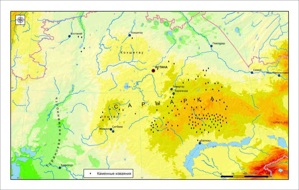
Fig. 1. Location of stone sculptures of the Turkic period in the Saryarka region on the map.
Aliya Manapova, Kalibek Assylbekov, Gulnaz Beisenbaeva, Nurdaulet Turmakhan, Aibobek Akkaliyeva, Assemgul Kassenova
МАИАСП № 21. 2025
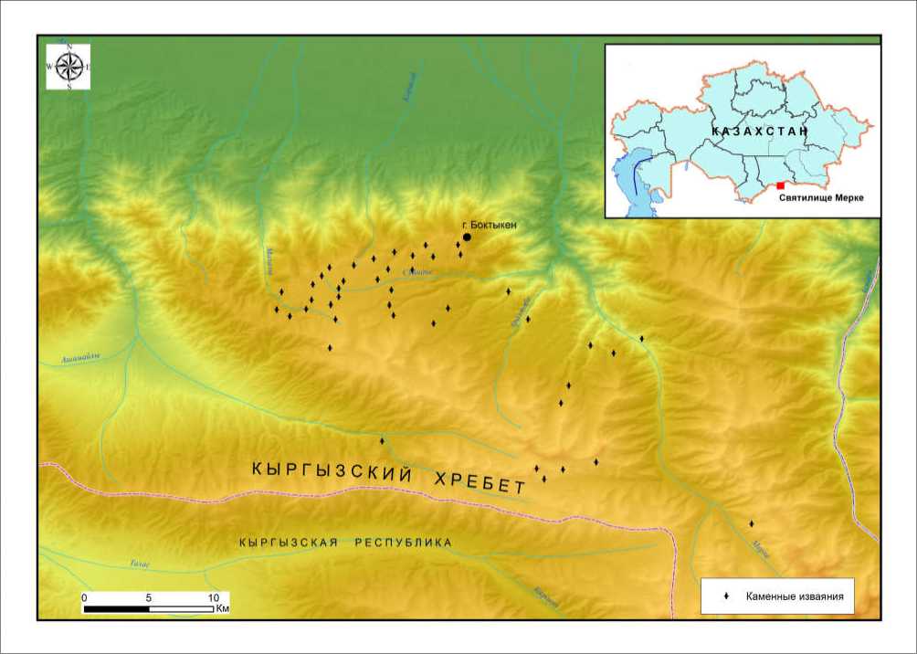
Fig. 2. Location of stone sculptures of the Turkic period in the Merke region on the map.
Table 1. Creating a register of stone sculptures using GIS technologies.
|
GIS function |
Significance for the registry |
Practical importance |
|
1. Spatial database (geodatabase) |
Saves coordinates, period, gender, preservation status, photos and scans of monuments as point/polygon attributes. |
Eliminates duplication, facilitates updating of information, and provides researchers with access through a unified structure. |
|
2. Cartographic visualization |
Shows distribution across natural regions, and connections with kurgans and ancient roads |
Enables filling research gaps by identifying unknown monuments in the inventory, and helps plan expeditions and protected areas. |
|
3. Analysis of landscape factors (DMR, hydropower, soil) |
Compares the location of sculptures with terrain, water sources, and geology |
Supports statistical substantiation of hypotheses regarding the selection of sacred sites and helps create predictive search models. |
|
4. Monitoring the current situation |
Add high-resolution satellite imagery and drone orthophotos to each object. |
Allows early detection of damage, erosion, or vandalism, and provides justification for protective measures. |
|
5. Integration with legal and museum systems |
Integration with cadastre, protected areas, museum collections. |
Facilitates the registration of monument status, museum transfers, and UNESCO/ICOMOS reporting. |
|
6. Web publishing |
WebGIS portal with filters by era, type, and status. |
Increases scientific transparency, engages local communities, and facilitates crowdsourcing to enrich the information. |
МАИАСП № 21. 2025
Stone sculptures of Jetisu and Saryarka: spatial patterns, iconography and the concept of gis-register
Table 2. Register of stone sculptures
|
№ |
District and object studies |
Brief description, size |
Photos, drawings (author of the photography and drawing) |
References |
|
1. |
Valley in the eastern part of Jungar Alatau |
Mongoloid face, head distinguished from the monolith, neck and shoulders schematically outlined, eyebrows stylized. Size: 1.80 (?) ×0.60 (?) m |
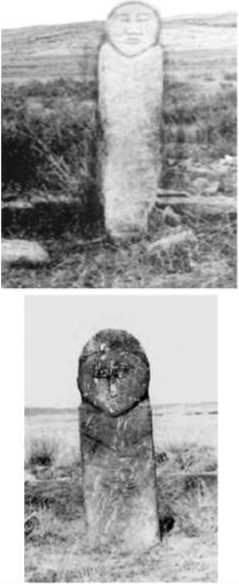
Ж |
Sher 1966 |
|
2. |
Photo archive of LBIA AS USSR |
Mongoloid face, eyebrows stylized. The head is separated from the torso by a thin schematic line representing the chin Size: 2.00 (?) × 0.40 (?) m |
Sher 1966 |
|
|
3. |
Jaisan Sanctuary |
The folds and hems of the outer garment are depicted, with an ornamented belt featuring a buckle and tip, a vessel, and a weapon in its sheath. The vessel, in the form of a cup, is placed at chest level and held in the left hand, while the right hand is pressed to the abdomen. Size: 1.95 × 0.55 × 0.30 m |
Dosymbayeva 2013 |
Aliya Manapova, Kalibek Assylbekov, Gulnaz Beisenbaeva, Nurdaulet Turmakhan, Aibobek Akkaliyeva, Assemgul Kassenova
МАИАСП № 21. 2025
Table 2. Register of stone sculptures (continued)
|
№ |
District and object studies |
Brief description, size |
Photos, drawings (author of the photography and drawing) |
References |
|
4. |
Jaisan Sanctuary |
Depicted are the lower hem of the garment, narrow sleeves with thin cuffs, belt, dagger, vessel, and earrings. The hair is parted with a center part and shown flowing down the back (the rough texture of the stone is successfully used for this effect) Size: 2.0 × 0.5 × 0.22 m |
и w |
Dosymbayeva, Bogenbay 2015 |
|
5. |
Sanctuary of Merke |
The sculptures are made of granite in bas-relief technique. The kurgan contains one male and two female sculptures. The male sculpture strictly follows the 181 iconographic canon, with emphasized portrait features and bent, crossed legs. On the female sculpture, the necklace (grivna) and breasts are depicted. In the hands of the sculpture, a flat-bottomed vessel is shown at waist level. Facial features are executed in a traditional, characteristic manner. |
Dosymbayeva 2013 |
|
|
6. |
Museum of Archeology and Ethnography SAI |
The sculpture is made of gray coarse-grained stone. A curved line at the top of the forehead reproduces the hairline. Size : 1.51 × 0.35— 0.40 × 0.15—0.20 m. |
Л ® ; -is |
Yermolenko 2013: 201, Fig. 1.1 |
МАИАСП № 21. 2025
Stone sculptures of Jetisu and Saryarka: spatial patterns, iconography and the concept of gis-register
Table 2. Register of stone sculptures (continued)
District and object studies

Brief description, size
At the fence. Kanahas tract, Nurtai River valley. Karaganda region, Aktogay district
Karashoky-2 tract. Balkhash Museum of Local History (Balkash city). Karaganda region, Aktogay district
Photos, drawings (author of the photography and drawing)