
The Afontova Gora IV (Ovrazhnaya) Site: An Analysis of a Complex with “Ocher” in the Structure of the Paleolithic Layer
Journal: Archaeology, Ethnology & Anthropology of Eurasia @journal-aeae-en
Section: Paleoenvironment, the stone age
Article in issue: 4 т.52, 2024.
Free access
We analyze a part of the Paleolithic layer of Afontova Gora IV (Ovrazhnaya) in Krasnoyarsk, evidencing intentional exploitation of outcrops of red sandstone and other local rocks. We describe archaeological finds and faunal remains, identify species important for subsistence. Based on the results of the intrasite spatial analysis, we separate an area of domestic activities centered on an open hearth. Scar-patterns and raw material links were analyzed. The preservation of the cultural context was demonstrated. The area likely functioned within a single activity episode. Types of activity are reconstructed. Primary reduction techniques applied to oval-flat pebbles to get first or second order blades were the same as those used to obtain ready wedge-shaped microcores transported to the site. To test the idea that red rocks were used as sources for mineral pigment, rock samples and archaeological artifacts were examined. In samples from Afontova Gora IV, no minerals that could be used to obtain the red pigment of the “ocher” type were found. Pieces of red rock brought to the site must have been used differently. The 14C-date of the complex with cultural remains is ca 18 ka cal BP.
Similar articles in the section Prehistory. Prehistoric remains, artefacts, antiquities
Short address: https://sciup.org/145147484
IDS: 145147484 | DOI: 10.17746/1563-0110.2024.52.4.075-084
Text of the scientific article The Afontova Gora IV (Ovrazhnaya) Site: An Analysis of a Complex with “Ocher” in the Structure of the Paleolithic Layer
Introduction been known since the 1920s due to the studies carried out by V.I. Gromov, G.P. Sosnovsky, and N.K Auerbach Afontova Gora IV as a separate archaeological site within (Sosnovsky, 1934: 257; Abramova et al., 1991: 100), the group of Paleolithic localities of Krasnoyarsk city has although I.T. Savenkov collected the first archaeological
The full-scale study of the site began at the turn of the 20th–21st centuries owing to the construction of the fourth bridge across the Yenisei and development of Nikolaevsky Avenue. Prospecting works carried out in 2011–2019 have revealed the exact location and limits of the site in the modern landscape forms (Meshcherin, 2020), and a new locus—Afontova Gora IV (Ovrazhnaya) in its western part (Fig. 1, A , B ).
In 2020–2022, the team headed by V.M. Novoseltseva, A.V. Barkov, E.V. Artemiev, and A.V. Vezhenko conducted rescue excavations at that locus, in an area exceeding 14,000 m2. The scope of the work ensured the adequate reconstruction of the spatial arrangement of cultural remains. The most informative materials were discovered in the cultural layer located in the roof of the Final Pleistocene sediments (Novoseltseva, Stasyuk, Akimova et al., 2020; Novoseltseva, Akimova, Stasyuk et al., 2020; Akimova, Novoseltseva, Stasyuk, 2021: 106). One of the findings was the identification within the Paleolithic deposits of complexes evidencing hunting specialization (Akimova et al., 2021), residential and utility zones (Razgildeeva et al., 2022).
The feature distinguishing the area under study from other zones of the site is the presence of fragments of red rocks among archaeological remains. In archaeology, finds of this sort are traditionally termed as “ocher” and regarded as evidence of natural pigments use (Popelka-
Filcoff et al., 2007; Pakhunov et al., 2014; Yanshina, Lev, Belousov, 2017). To prove the assumption that ancient inhabitants of Afontova Gora used red rocks as sources for mineral pigments, local rock samples and archaeological artifacts were examined. Findings did not reveal the presence at Afontova Gora IV of minerals that could be used for making the red pigment. Pieces of red rock brought to the site must have been used for different purposes.
Geomorphology, stratigraphy, and taphonomy
Afontova Gora IV (Ovrazhnaya) is located on the left bank of the Yenisei River, on a plateau-like surface near the top of Mount Afontova, at a level of 220–236 m according to Baltic Height System, within accumulative terrain. The western part of the site is associated with cover deposits of a high (85–101 m) terrace gradually merging with a gentle, southeast-facing slope. The system of ravines influenced significantly the character of exogenous processes and the structure of Quaternary deposits. The original landscape underwent irreversible changes; therefore, the streets of Nikolaevskaya Sloboda – Ovrazhnaya and 1st Baikitskaya were chosen as conventional landmarks. These streets actually run along ancient ravines.
The accumulation of cultural remains in question was located on a platform, ~250 m2 in size, hypsometrically dominant within the upper tier of the southeastern slope, flattened by denudation, and gently declining
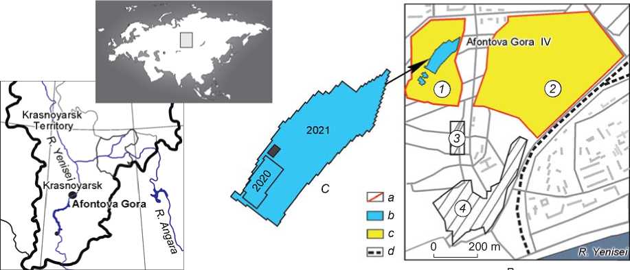
Fig. 1. Location of Afontova Gora IV (Ovrazhnaya).
A – scheme of the study area; B – situational plan: 1 – new locus of the Afontova Gora IV (Ovrazhnaya) site, 2 – territory of the Afontova Gora IV site in the 1920s, 3 – the Krutaya site, 4 – the Afontova Gora II site; a – boundaries of the archaeological heritage object, b – excavated areas, c – total area of the Afontova Gora IV site, d – railway; C – scheme of the excavated area of locus II, with the complex under study (marked) .
toward the Yenisei River (Fig. 1, A , B ). Archaeological remains were found at a depth of 0.2 m from the daylight surface, in the lower portion of light-brown sandy loam (lithological stratum 3, hereinafter LS 3). In the geological section, the upper part of the Holocene deposits of the Yenisei terrace proper, including the LS 3 roof, was obliterated by technogenic impact and replaced.
The geological sections of the area under study (excavation 5, loci 7 and 14) include:
LS 0 – modern technogenic deposits: mixed humified loam with domestic waste and mixed loams covering LS 0.1. The lower boundary is broken. Thickness is 0.02–0.17 m.
LS 0.1 – arable horizon of the modern soil complex: mixed chernozem soils. The lower boundary is even and distinct. Thickness is 0.15–0.22 m.
LS 3 – pale-yellow-brown, yellowish-gray loesslike sandy loams; light, porous, homogeneous, non-carbonaceous, non-laminated with lightly humified inclusions along the top. The boundaries are washed out, uneven, and indistinct. Thickness is 0.1–0.3 m.
LS 4 – light-gray loess-like sandy loams; porous, non-laminated. The whole stratum is impregnated with carbonates forming stains and flows. Visible thickness is up to 1.2 m.
The culture-bearing layer within the study area is partially destroyed by the road bed. The zone containing hearth is cut by technogenic pits on three sides (Fig. 2, A ). The northwestern part of the hearth is covered by a lens of reddish-brown soil up to 4 cm thick, which was formed around the roots of a modern maple above the hearth spot (Fig. B ; C , 4 ). Outside the technogenic pits, in the area measuring ~50 m2, culture-bearing deposits have been preserved in situ , with remains of manufacturing activities arranged mostly horizontally.
Methods
Archaeological research at the site was carried out using traditional methods of field studies. Stadia surveying of all the finds recorded in situ (including those of the micro category) was conducted. To understand the spatial organization of the site, methods of quantitative analysis, refitting, and identification of raw material units were employed. The reconstruction of activities was based on technical-typological and morphological analysis of artifacts. Pigments of the “ocher” type in rocks and soil were studied by X-ray powder diffraction. Some artifacts were examined by the petrographic method. Species composition of the fauna was identified to characterize the subsistence base.
Intrasite spatial organization
The main element of the habitation area—the hearth— is represented by a rounded spot of colored soil (3–4 cm) measuring 60 × 55 cm, encircled by archaeological remains. The cross-section of the black infill lens has a cup-shaped form (Fig. 2, B ; C , 2 , 4 ).
Near the hearth, there lay two slightly rounded sandstone cobbles with their long axes oriented towards the hearth’s center. A subrectangular stone (18 × 8 × 8 cm) lay on its sharp edge in the southern part of the spot. A fissured stone fragment subtriangular in cross-section (24 × 10 × 12 cm) adjoined the spot from the east (Fig. 2, B ; C , 5 ). The base of the fragment lay on light sandy loam, which suggests that this stone had been present here since the early stages of the hearth use. Facets of the stones demonstrate reddish stains.
East of the boulders, there is a washed out spot of gray-black soil, fragments of split bones, including charred ones, and small debitage pieces (Fig. 2, B ; C , 4 , 5 ). Excavations between the stones revealed a pit (3 cm in diameter and 8 cm deep) filled with substance of intense black color. Closer to the stone subtriangular in cross-section, there was a fragment of a siliceous sandstone cobble of gray and mossy green color (12.8 × 7.8 × 6.8 cm). The cobble was knapped from narrow ends, and the detached flakes were embedded in the stratum. Five centimeters west of the hearth, in an area measuring 10 × 12 cm, a fragment of reindeer phalanx, unidentifiable split bones, flakes, and fragments of gray-pink sandstone tablets were found (Fig. 2, C , 1 ). Short fragments of the bones lay horizontally. Another minute accumulation of bones including a longitudinal fragment split from a large bone, fragmented ribs and vertebrae of Equidae gen., and unidentifiable osteal fragments was recorded 15– 20 cm south of the hearth spot. Some bones were found in vertical position, probably in a small pit (~10 cm in diameter, and ~15 cm in height). Ten centimeters south of this accumulation, the layer was disrupted by a technogenic pit.
Sediments outside the hearth zone were indistinct in terms of coloration: slightly brownish sandy loam was recorded near the bone accumulations, and reddish, in the areas with red rocks (Fig. 2, C , 3 , 6 ).
A statistically significant cluster of debitage and fragmented rocks and bones was recorded in an area measuring ~5 m2, 2 m southeast of the hearth. The periphery of the habitation area was marked by bone splinters. Fragments of reindeer antlers and those of a tibia were identified. Long fragments were arranged irregularly, while location of some pieces followed the microrelief.
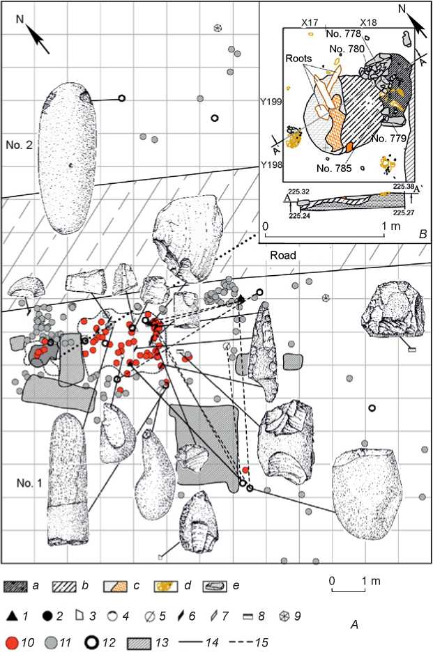
Fig. 2. Part of the Paleolithic layer of Afontova Gora IV.
A – plan of the complex with the scheme showing location of lithic artifacts: 1 , 2 – debitage, 3 – burin, 4 – end-scraper, 5 – tool fragment, 6 – blade, 7 – microblade, 8 – retouched implement, 9 – core, 10 – “ocher”, 11 – bone, 12 – fragment of a pebble, 13 – technogenic pits, 14 – projection of artifact point, 15 – refitting links; B – plan and profile of the hearth: a – charcoal spot, b – charred sediment, c – soil lens with a root, d – bone fragments, e – stones near the hearth; C – components of the cultural layer: 1 – cluster of archaeological remains west of the hearth, 2 – piece of “ocher”, 3 – rock fragments, 4 – hearth with the lens around the root, 5 , 6 – clusters of finds.
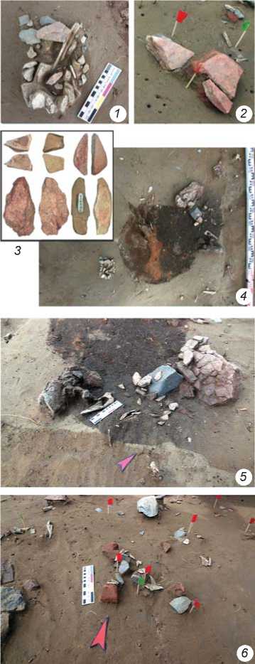
C
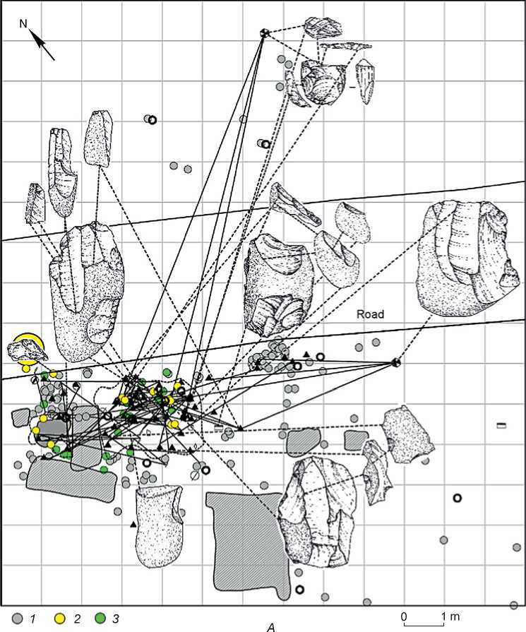
In the area north-northeast of the hearth, the culturebearing layer was destroyed by the earth road. On its side, 4.5 m of the hearth, a cluster of bone splinters and lithics, including fragments of sandstone, was found. A large pebble core (9.6 × 8.1 × 5.4 cm) was discovered 9 m northeast of the hearth (Fig. 3, 11; 4). Fragments of blades detached from the core were identified in the cluster located 2.5–3.0 m of the hearth. A wedgeshaped core (see Fig. 3, 3), located behind the road, 11 m of the hearth, marked the limit of the habitation area. Microcore rejuvenation flakes were found among debitage in the central cluster (see Fig. 4).
Lithics and fauna remains
The artifact assemblage consists mostly of small and medium debitage pieces (60 %) (see Table ). The informative material is scarce (~30 spec.). Primary reduction is shown by a single-platform unifacial core
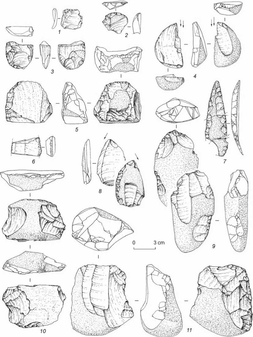
Fig. 3. Lithic artifacts.
1 – retouched flake; 2 – end-scraper; 3 – wedge-shaped microcore; 4 , 8 – burins; 5 – scraper-like (?) tool; 6 – fragment of a retouched blade; 7 – point; 9 , 11 – cores; 10 – chisel-like (?) tool.
on a large pebble (see Fig. 3, 11 ), a core on an elongate pebble with traces of rejuvenation and a series of blades detached from it (see Fig. 3, 9 ), a wedge-shaped microcore (see Fig. 3, 3 ), and rejuvenation flakes (8 spec.). A nodule of green siliceous sandstone with an inner defect exhibits a failed attempt of flaking.
The tool kit comprises two burins (see Fig. 3, 4 , 8 ), an end-scraper on a flake (see Fig. 3, 2 ), a point composed of three fragments (see Fig. 3, 7 ), a chisel-like (see Fig. 3, 10 ) and a scraper-like (see Fig. 3, 5 ) implements, a large hammerstone, a retoucher on a small pebble, a large retouched flake, two fragments of blades,
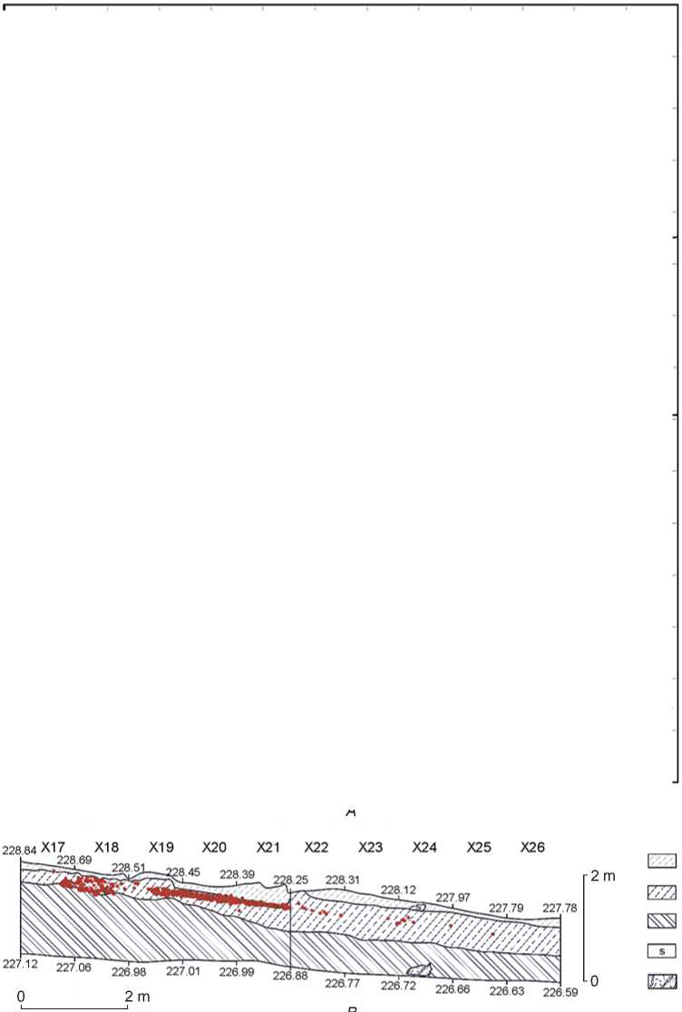
Fig. 4. Refitting links between cores and groups of raw material units ( A ): 1 – bone, 2 , 3 – groups of elements of raw material units; stratigraphic transect with the projection of artifacts ( B ): 1 – lithological stratum 0, 2 – lithological stratum 2, 3 – lithological stratum 4, 4 – stone, 5 – technogenic pits. Red points stand for the location of finds.
two retouched flakes, and two elongate sandstone pebbles with heavily worn surfaces. At least seven pebble tools are represented by fragments.
The culture-bearing layer within the habitation area was marked by tabular fragments resembling blocks of “ocher” by their reddish color (see Fig. 2, C, 3, 5). Near the hearth and in the cluster located northeast of it, over 220 fragments of this sort, including nodules in the form of broken bars and pencil-shaped pieces with smoothed facets, were found. The petrographic
Composition of the complex with “ocher” at Afontova Gora IV, excavation 5, number of specimens
Faunal remains (800 spec.) are dominated by fragments of split long bones and small splinters. Identifiable remains include bones of hooves (21.8 %), elbow (8.7 %) and ankle (4.4 %) joints, incisors and tooth fragments (56.3 %), fragments of reindeer ( Rangifer tarandus ) antlers (4.4 %), and fragments of chest (24 spec.) belonging to a juvenile individual of an unspecified equine (Equidae gen.). Near the hearth, fragments of mammoth bones, including one rather large specimen measuring 12.2 × 1.9 × 1.6 cm, were discovered.
Discussion
Quantitative analysis of finds upheld the presumption that domestic activity zones concentrated near the hearth and northeast of it. The periphery of the habitation area is marked by isolated artifacts lying at a distance not exceeding 11–12 m from the hearth (see Fig. 2, A ; 4). As to the location of the pebble core (see Fig. 3, 11 ; 4), it could probably have been moved down the slope by some natural processes. The wedge-shaped microcore, owing to the absence of slope in the microrelief, could not have been moved in that manner, so chances are that it had been transported by humans (see Fig. 3, 3 ; 4).
The composition of the lithic assemblage points to the purposeful selection of raw materials. Large flakes and tools were made of fine grained sandstones and argillites. Microdebitage indicates the predominant use of siliceous rocks similar to jasper and flint. Refitting makes it possible to reconstruct the primary reduction stage of oval-flat pebbles (up to 13 cm long): removal of cortical flakes, including those of blade variety. Judging by fragments of prismatic microblades (34 spec. found around the hearth, and 14 spec. in the eastern cluster) and rejuvenation flakes, not only the wedge-shaped core (see Fig. 3, 3), but also microcores made of light brown flint and light green jasper (see Fig. 4, yellow and green points) were flaked. The width of the bladelets (up to 1 cm) and microblades (3–5 mm) suggests that they were obtained intentionally. The assemblage includes the distal part of a thin rectangular pebble (6.7 × 3.7 × 2.4 cm) with a facet of blade removal on the ridge, and implements on cortical blades detached from pebbles of the same shape (see Fig. 3, 7).
Tools of the complex demonstrate the spheres of domestic and stone reduction activities. Ten implements are associated with the former. This category includes an end-scraper (see Fig. 3, 2 ), a retouched cortical blade (typologically a point) (see Fig. 3, 7 ), and a double burin (see Fig. 3, 4 ). A pebble flake (see Fig. 3, 10 ) with alternate retouch along the convex edge could have been used as a scraper, a cutting or chisel-like tool. There is a series of cortical flakes refittable with this implement. Two artifacts—the distal part of a semicortical blade and the medial fragment of a retouched trihedral blade (see Fig. 3, 6 )—are represented by fragments. Informal tools include a flake with use retouch (see Fig. 3, 1 ) and a robust pebble flake of siliceous sandstone (9.0 × 6.4 × × 2.5 cm). The latter, judging by polished surface of the thin convex edge, could have been used as a knife. Two other implements—a scraper-like pebble fragment (5.9 × 6.3 × 3.4 cm) and a cortical flake with burin spalls (6.3 × 3.9 × 1.0 cm) made of green flint—are patinated (see Fig. 3, 5 , 8 ). Given the appearance of these finds and their location in the periphery, apart from other artifacts, it may be suggested that they were destined for other purposes.
Other tools lay compactly in the area of the main cluster within 1.5 m from the hearth (see Fig. 2, А ; 4). Almost all the artifacts with use-wear signs are represented by fragments. They have working edges typical of cutting and scraping tools.
Refitting links (13 blocks) and groups of raw material units (fine- and coarse-grained variously colored siliceous sandstones) were identified within an area of ~250 m2, which, in our view, indicates a single habitation episode (see Fig. 4). Stone knapping served multiple purposes and resulted in both large primary blades and microblades. The debitage also reflects the process of tool-making and utilization. To replenish the toolkit, the transported supply of raw material was used: preforms of cores and siliceous rocks selected by size and shape, with a view of receiving subprismatic and wedge-shaped cores.
The industry reveals a focus on local outcrops of red sandstone and other rocks resembling “ocher” (see Fig. 2, C , 2 , 3 , 6 ). Pieces of rocks are laminated tabular concretions of coarse-grained or powder texture, pink, light crimson, bright red or orange in color.
The artifact assemblage comprises a series of transversally broken elongate pebbles of “heavy” effusive rocks. Use-wear signs and character of fragmentation suggest that they could be used as pestles/grinders for rocks. Together with the pebble-retoucher (9.3 × 4.0 × × 1.9 cm) (see Fig. 2, A), discovered in the southern portion of the debitage accumulation, these finds are attributed to the group of tools used for stone reduction.
Traces of paint can be observed not only on the fragments of red concretions, but also on two implements. One of them is an oblong and flat sandstone pebble, partly composed of two fragments. Intense usewear on opposing sides of its distal and medial parts suggests that the pebble was first fragmented, and then the fragments were utilized from different planes. On another pebble of ellipsoid shape, three areas damaged by pecking are visible along the lateral surface in the thick part. Its thin end displays signs of flattening. The fact that the fragments of the former tool were remote from each other can be explained either by movements of one and the same individual during work or by more than one person being engaged in the fragments’ use (see Fig. 2, A , No. 1 ). The second tool was found behind the road, not far from the microcore (see Fig. 2, A , No. 2 ). The area with the typical pecking erosion suggests that the pebble could have been used as a support during flaking.
Some pebbles of coarse-grained rocks (andesites, basalts) were probably used for crushing stone slabs. If large backed fragments and refittable ones are included, then eight specimens can be regarded as hammerstones. The pebbles are large and heavy, with flaked narrow sides or fragmented. As refitting has shown, transversal flakes and their fragments were located near red rock pieces. Backed fragments were associated with the periphery of the platform.
A distinctive feature of this part of the Afontova Gora IV (Ovrazhnaya) site is that its cultural layer is partially red, which is usually due to the erosion of Riphean, Ordovician, and Devonian red-colored sedimentary and igneous rocks. In this case, the red rocks are of interest as a potential raw material for the “ocher”. This specific geological feature of the region has not been previously studied in the context of finding sources of the “ocher” and their use by ancient inhabitants of Afontova Gora. Therefore, while examining the artifacts and culture-bearing sediments, we paid special attention to the presence of the coloring mineral.
In archaeology, “ocher” belongs to the group of pigments varying in color from yellow to bright red. Yellowish-red coloration of rocks is associated mostly with the presence of the iron-group (Fe) minerals, less often with the manganese (Mn) group. The most common mineral that ancient people used as the red pigment was hematite (Fe2O3). Observations show that even a small amount of hematite adds color to rocks and culturebearing sediments (Tetenkin et al., 2020: 16, fig. 3 d, i–l). At Afontova Gora IV, no hematite-rich rocks or ocher pieces that could be used for practical purposes have been found. However, exposures of hematite ores occur ~70 km east and ~50 km south of the site (the right side of the Krasnoyarsk Reservoir) (Gosudarstvennaya geologicheskaya karta…, 2009). The farthest potential geological sources are located more than 200 km north and northeast of the site. Whether people of Afontova Gora IV used red-colored rocks from the nearby outcrops as raw material for producing pigment (ocher) remains an open question.
Conclusions
The findings of the study of part of the Afontova Gora IV (Ovrazhnaya) site have enabled us to reconstruct some of the ways humans processed the red rocks. While hypsometrically the habitation area dominates the slope, the culture-bearing layer in the geological transect occupies a stable position at the bottom of lithological stratum 3. The age of the archaeological remains is determined by the radiocarbon dates of 15,431 ± 71 (GV-4209) and 15,153 ± 75 (GV-4196) uncal BP, generated on a reindeer tooth fragment and an epiphysis of a vertebra of a young (?) horse, respectively.
The analysis of spatial arrangement of the finds evidences a loose concentration of cultural remains in the open space around the hearth. The hearth is small (~0.6 m in diameter); stone lining is absent, though stones lying near the hearth could possibly bear relation to its construction. The artifact assemblage comprises debitage of qualitatively different raw materials. Primary reduction is represented by pebble cores. Technological analysis suggests that relatively large cortical flakes were detached unintentionally. Microblades are represented solely by fragments up to 5 mm long. We have revealed traces of processing the microcores that are absent in the collection. Refitting links indicate the use of artifacts from the raw material units in various activity cycles in the study area of Afontova Gora IV, while the implements form a small set that could be easily transported. The diet can be characterized by the remains of fauna, which include the identified bones of a reindeer and a young individual of Equidae gen. The season of death of the animals could not be determined.
The accumulation of fragments of red rocks indicates that they were brought to the site intentionally. Judging by the presence of open outcrops of those rocks near Krasnoyarsk Akademgorodok, these were easily available for the site inhabitants. Because of a very low content of coloring minerals, the rocks were not specially used to obtain pigments. Still, people could have used them for utilitarian or ritual purposes.
Acknowledgments
