
The First Results of Remote Sensing Studies of Mounds with “Mustaches” in Northern Kulunda, Southwestern Siberia
Journal: Archaeology, Ethnology & Anthropology of Eurasia @journal-aeae-en
Section: The metal ages and medieval period
Article in issue: 4 т.52, 2024.
Free access
In 2019, a group of previously unknown mounds with “mustaches” was discovered in the north of the Kulunda steppe. They are quite unusual: all of the mounds are ground and located on floodplains. In 2023, a set of remote sensing methods (aerial photography, electromagnetic profiling, and electrical resistivity tomography) was used at Karasuk-1 and Troitskoye-1 to assess the design of the mounds and see if additional features were present on their periphery. For this type of structure, geophysical methods were employed for the first time. Maps based on aerial photography data have made it possible to record the relief features of objects in high detail. Troitskoye-1 consists of five rather than four mounds. Using the electrical tomography method, the composition of the mound platforms was shown to be homogeneous. On geoelectric sections, they correspond to conductive areas ca 0.5 m thick. At both sites, the central mounds do not have “walls” on the eastern side. Apparently, no removal of soil was carried out on that side, in order to provide access to the ritual areas from the space enclosed by the “mustaches”. According to the results of aerial photography, at Karasuk-1 cup-shaped depressions were discovered on the surface of the western ends of the “mustaches”. They can be tentatively associated with the design of the mounds. The northern “mustache” is markedly broken. No additional features were identified inside or near the mounds. The results suggest that both complexes were built at the same time and are autonomous.
Similar articles in the section Archaeology
Short address: https://sciup.org/145147474
IDS: 145147474 | DOI: 10.17746/1563-0110.2024.52.4.117-124
Text of the scientific article The First Results of Remote Sensing Studies of Mounds with “Mustaches” in Northern Kulunda, Southwestern Siberia
Mounds with “mustaches” are large complexes of ancient structures common on the Eurasian steppes. Currently, over six hundred such complexes have been discovered on the steppe belt from the Southern Trans-Urals to the Irtysh River. The number of mounds with “mustaches” and the size of their distribution area indicate that these
sites reflect a powerful constant in the ritual practices of nomads over the centuries.
In general terms, mounds with “mustaches” constitute a complex of one or more stone mounds (“kurgans”), from which two arched stone (less often earthen) ridges (“mustaches”) extend mainly in the eastern direction (Grudochko, 2020: 47; Beisenov, 2017: 32). The length of these ridges varies greatly (from 10 to 280 m) and may differ even within a single site. The ends of the “mustaches” were shaped in a special way: with mounds, stone circles, etc. The amounts of central mounds and variants in their relative positions have been provided in several typologies by Soviet, Kazakh, and Russian scholars (Margulan et al., 1966: 309; Beisenov, 2017: 32, 33; Lyubchansky, 2006: 386–390; Botalov et al., 2006: 91; Grudochko, 2020: 47, 48).
The sites have been divided into several large territorial groups (Grudochko, 2020: 38, 46; Beisenov, 1996; Botalov, Tairov, Lyubchansky, 2006: 10). In 2019– 2023 a new group of such structures was discovered in the north of the Kulunda steppe in the valleys of the Karasuk, Baganenok, and Bagan rivers (Grishin, Marchenko, 2022). This group is very isolated, since the distance to the nearest known mounds with “mustaches” in Northern Kazakhstan is over 300 km. Twenty sites have been currently discovered. Exploration surveys continue to investigate them and search for new sites (Marchenko, Grishin, 2023).
The Northern Kulunda group of mounds with “mustaches” is very distinctive: the overwhelming majority of the structures are located on floodplains. Therefore, they are not classified as kurgan burial grounds, in that they are associated with elevated
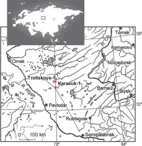
Fig. 1 . Location of the Karasuk-1 and Troitskoye-1 sites.
landforms. Another specific feature of the Northern Kulunda group is the exclusively ground nature of the structures. Previously, similar complexes were known only in the Southern Trans-Urals; but there, only the “mustaches” were made of soil, while the central mounds were made of stone (Grudochko, 2020: 77, 78).
Currently, the Northern Kulunda group of mounds with “mustaches” is the easternmost in the area of distribution of such sites, and clearly deserves detailed study. Unfortunately, this is difficult; owing to the significant size of most mounds with “mustaches” their full-scale archaeological examination is very expensive. Therefore, it is important to assess the prospects for studying these sites using geophysical methods. To the best of our knowledge, such work has not been done as of yet. Thus, this study was aimed to test a set of remote sensing methods for establishing the structural features of mounds with “mustaches” and detecting associated sites on their periphery. The set of methods included aerial photography, electromagnetic profiling, and electrical resistivity tomography. The Karasuk-1 and Troitskoye-1 sites, located in the Karasuksky District of the Novosibirsk Region (Fig. 1), were chosen as objects for the research.
Description of the objects for research
The Karasuk-1 site is located on the left bank of the Karasuk River, 3.4 km southeast of the city of Karasuk. It consists of a rounded flat mound (17 m in diameter and 0.3 m high), from which two arched ridges extend to the east. Their length along the crest is 108–114 m; their height reaches 0.2 m, and their width in different sections ranges from 4 to 9 m. The ends of both ridges pass smoothly on to rounded platforms with a diameter of 7–12 m and height of 0.14–0.30 m. All of the mounds have flat surfaces and are loosely covered with sod. Amorphous hollows—places of soil extraction—were found near the central structure and along the perimeter of the ridges. As a whole, the complex is almost symmetrical along the longitudinal axis. Its total length is 117 m with a maximum width of 102 m.
The Troitskoye-1 site is located on the right bank of the Karasuk River, 1 km north of the village of Troitskoye (Marchenko, Grishin, 2023: Fig. 1). The complex consists of a chain of four rounded mounds oriented along the SW–NE axis. Their diameter is 10–13 m and height is 0.24–0.28 m. Two curved ridges 4.5–7.0 m wide and up to 0.15 m high extend from the outermost mounds. Their ends have rounded and teardrop-shaped structures with a diameter of 6.5–7.0 m and height reaching 0.15 m. All mounds of the complex have flattened surfaces and are loosely covered with sod. Hollows of uneven depth (places of soil extraction) are observed around them.
The entire structure is oriented with the longitudinal axis along the WNW–ESE line. The total length is 137 m with a width of 129 m.
Study methods
Aerial photography . Advances in fixed-wing and multirotor aircrafts, as well as reduced sizes of cameras and other additional equipment, ensure high effectiveness and widespread use of aerial photography in archaeological surveys. Detailed orthophotoplans, digital elevation models, and multispectral survey data provide valuable information about archaeological sites. They are used to interpret the results of comprehensive remote sensing studies and to plan geophysical works (Zhurbin et al., 2022). Aerial photographs were taken using a small-sized DJI Mavic Air quadcopter (Balkov et al., 2020). The data were processed using Metashape and Surfer software.
Electromagnetic profiling . This is an effective, non-contact method for quick assessment of specific electrical resistivity of the upper part of a section (Balkov et al., 2023; Batanina, Kupriyanova, Muraviev, 2023). Measurements were taken using Geoviser equipment (Karin et al., 2018) at a frequency of 100 kHz, with data referencing to GNSS receivers with centimeter-level accuracy. The entire area of the sites was profiled using a device towed behind a tracked carrier (Balkov et al., 2023). The distance between the survey pegs was 0.5– 1.0 m, and between profiles the distance was 2–3 m. To increase the level of detail, surveys on foot were carried out in some sections, with a distance of 0.3–0.5 m between the survey pegs and no more than 1 m between profiles.
Electrical resistivity tomography . This method has proven to be very successful and has been widely used for detailed study of the geoelectric structure of archaeological sites. It is more resource-intensive than electromagnetic profiling, but has a better capacity for 2D and 3D interpretation (Modin et al., 2023). In this study, the method of electrical resistivity tomography was used both in the form of profile survey and in the pseudo-3D electrical tomography version. Measurements were taken using a Schlumberger unit along a series of parallel profiles. The distance between profiles was 1 and 2 m, with distance within the profile of 0.5 m. Skala-32k4 equipment with thirty-two electrodes and four-channels was employed (Balkov et al., 2023). Data inversion was carried out using Res2DInv and Res3DInv software.
Study results
Karasuk-1. A map of relative heights (Fig. 2, a), which displays local depressions and elevations without taking into account the regional relief, was constructed after processing the data of aerial photography (Balkov et al., 2020). The relief features of the site were clearly visible, including the central mound and two symmetrical “mustaches” with rounded extensions at the ends. Hollows (“ditches”) for soil extraction were found along the ridges and near the mound. On the surface, the transition from the ridge to the hollows was manifested by a sharp change in vegetation, which is well reflected on the orthophotoplan (Fig. 2, c). A noteworthy feature is the bowl-shaped surface on the western ends of the “mustaches”. It was most clearly seen on the southern ridge through which profile 1 of electrical resistivity tomography was laid (Fig. 2, a). As can be seen in the graph of the digital relief along this profile (Fig. 2, b) where the height of the mound is 0.25 m or less, the depth of the depression in its center reached 0.15 m. The eastern ends of the ridges had flattened surfaces, which is clearly demonstrated in the graph of the digital relief along profile 2 (Fig. 2, a, b).
Upon detailed examination of the central mound, it was discovered to have an asymmetrical C-shaped form with a central depression. It did not have a “wall” on the eastern side. Its size was about 12 × 15 m, the depth was about 0.5 m. The arc at the beginning of the northern “mustache” was uneven, which is most clearly seen from the data of electromagnetic profiling (Fig. 2, d ). In addition, there was a large cross-shaped area (ca 50 × × 50 m) in the center of the structure, showing altered vegetation (Fig. 2, c ) and increased resistivity (Fig. 2, d ), but not visible in the relief (Fig. 2, a ).
Soils at the site had low resistivity (up to 10 Ohm∙m). Relative to the reference environment, the mound areas showed reduced values (1–2 Ohm∙m), while the hollow zones surrounding them showed increased values (5–50 Ohm∙m). According to the profile of electrical resistivity tomography laid through the central mound, the thickness of the zone of reduced resistivity was ca 0.5 m.
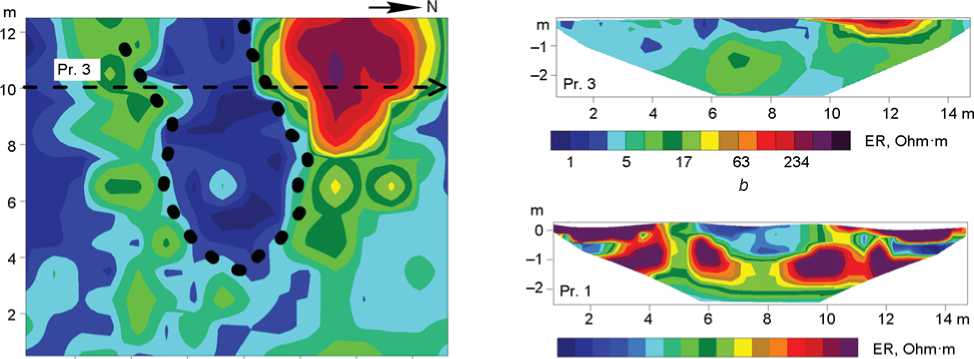
Based on the geoelectric section passing through the western end of the southern “mustache” (Fig. 2, a ; 3, c ), the initial depth of the hollows was 0.5–0.6 m from the daylight surface. The conductive area corresponding to the mound at that end extended to a depth of about 1 m and was fairly uniform. A detailed study was carried out at the eastern end of the southern “mustache” along a number of parallel profiles using electrical resistivity tomography (see Fig. 2, a ). According to its results, especially in the horizontal section, at a depth of 0.1 m, the end of the southern “mustache” was a conductive area without significant local inclusions. The zones corresponding to the “ditches” had a higher electrical resistivity (see Fig. 3, a , b ).
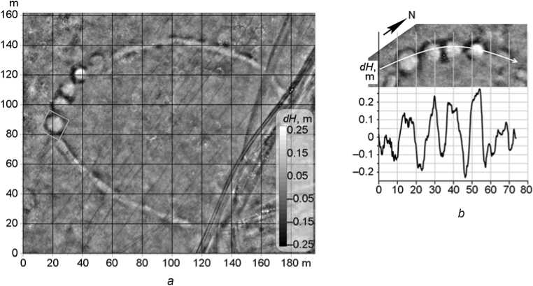
Troitskoye-1 . The map of relative heights (Fig. 4, a ) clearly shows that this complex, unlike the previous one, was not symmetrical relative to the central axis. Places
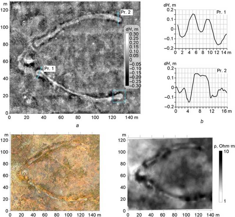
Fig. 2 . Results of geophysical studies at Karasuk-1.
a – map of relative heights; b – profiles constructed from the data of the altitude map; c – orthophotomap; d – map of the apparent resistivity distribution created using measurements by Geoviser equipment.
of soil extraction, which emphasize and additionally highlight the raised sections of the structure, were clearly seen. As with Karasuk-1, the change in relief was accompanied by marked changes in vegetation (Fig. 4, a , c ).
The research revealed that five rounded mounds constituted the basis of the Troitskoye-1 complex. One of them (the northernmost), measuring about 10 × 12 m and 0.15 m high, was the least expressed in relief, and was not initially identified at the time when the site was discovered. Its presence was confirmed by the profile of relative heights laid through all the central mounds (Fig. 4, b ), as well as by the orthophotoplan and data of electromagnetic profiling (Fig. 4, c , d ). In addition, the following feature was clearly seen in all the mounds of this complex: their relief manifestations on the interior (eastern) side were minimal or absent. The depression on the surface of the western end of the southern “mustache”, observed during archaeological survey, was not visible on the created maps.
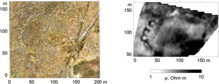
On the southernmost mound in the chain of central mounds at Troitskoye-1 (Fig. 4, a ), measurements were taken along a number of parallel profiles using electrical resistivity tomography, which made it possible to construct a three-dimensional geoelectric model. The contour of the area of reduced electrical resistivity values (1–2 Ohm∙m), corresponding to the mound, was visible on the section at a depth of 0.27 m (Fig. 5, a ). According to the geoelectric section along profile 1 (Fig. 5, b ), its thickness did not exceed 0.5 m. As with Karasuk-1, no local non-uniformities were found in the structure of the mound.
Discussion
The studies have shown that both sites were very similar and were obviously constructed following a common standard. In both cases, the central mounds were flattened platforms of rounded shape, with a diameter of 10–13 m
2 4 6 8 10 12 14 m 1.4 1.8 2.4 3.1 4.1 5.3
аc
Fig. 3 . Results of electrical resistivity tomography of the ends of the southern “mustache” at Karasuk-1. a – resistivity map at a depth of 0.1 m (eastern end); b , c – geoelectric sections of the eastern and western ends, respectively.
d c
Fig. 4 . Results of geophysical studies at Troitskoye-1.
a – map of relative heights; b – altitude profile through the central mounds; c – orthophotomap; d – map of apparent resistivity.
(Troitskoye-1) and 17 m (Karasuk-1). According to the data of terrain survey by electromagnetic profiling and electrical resistivity tomography, the mounds stood out against the surrounding environment and were distinguished by reduced values of electrical resistivity (1–2 Ohm∙m) (Fig. 5, a ). Analysis of the geoelectric sections did not reveal any non-uniformities in their internal structure (Fig. 5, b ). No conductivity anomalies, which could be correlated with pits or calcinations, were detected.
An interesting feature of the central mounds of both sites, which was revealed by aerial photography and electromagnetic profiling, was the absence of the eastern “wall” (see Fig. 2, 4). Apparently, soil for constructing the mounds was not extracted on the eastern side, in order to provide access to the mounds. Extensive (ca 1500 m2) zones with increased electric resistivity, which also differed in vegetation, were present at both complexes. They were confined to the center of the area limited by the “mustaches”, which can be seen especially clearly at Karasuk-1. These areas could have been associated with some ritual activities, and similar zones may be identified at other complexes in the course of further studies.
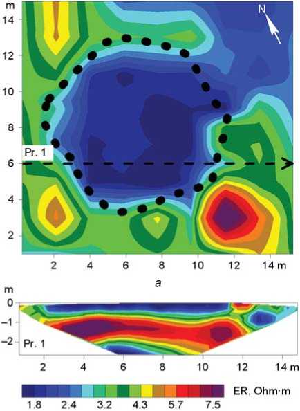
b
Fig. 5 . Results of electrical resistivity tomography at Troitskoye-1.
a – resistivity map at a depth of 0.27 m; b – geoelectric section along profile 1.
The ends of the “mustaches” were studied only at Karasuk-1. Judging by the electrical resistivity tomography data, their geoelectric features were similar to those established for the central mounds (see Fig. 3, 5). According to aerial photography, in the center of the western ends of both halves of the “mustaches”, there were cup-shaped depressions, which had not been previously (visually) identified. Similar depressions have been discovered at other sites of the Northern Kulunda group of mounds with “mustaches”. For example, depressions in the center of the ends of the “mustaches” were found at the Melkoye-13 site and on one of the two central mounds at the Gramotino-1 complex (Grishin, Marchenko, 2022: 482, 483). Based on the elevation data, a similar depression may also be near the central mound of Karasuk-1 (see Fig. 2, a ). In the main area of distribution of mounds “with mustaches”, depressions in the centers of the mounds have been identified many times, for example, at the complexes of Sultantemirovsky I and Sarbulat-1 (Grudochko, 2020: 62, 67). These have been attributed mainly to the consequences of robbery or structural features of the complexes.
The “mustaches” on the created maps were clearly visible according to all types of data. Electrical resistivity tomography and electromagnetic profiling revealed that the “mustaches” had the same geoelectric features as other mounds (see Fig. 2, a ; 3, a ). Since there is still insufficient data, it is difficult to say whether the ridges were formed on the ancient surface as was the case at the majority of the sites, or were made in a shallow pit, as, for example, at Solonchanka I (Ibid.: 78).
The “ditches”, remaining after soil extraction, were also well recorded by aerial photography (modified vegetation), electromagnetic profiling, and electrical resistivity tomography (areas of high resistivity). The maps showed that the “ditches” additionally emphasized and accentuated the raised parts of the structures (see Fig. 2, 4). Similar finds were previously discovered at the sites in the Southern Trans-Urals where the “mustaches” were made of soil (Solonchanka I, Krutaya Gora, Rymniksky) (Ibid.: Fig. 46, 1 ; 100). Interesting observations were made during the excavations at the Solonchanka I complex, where the “ditches” did not reach the sterile soil. This suggested that the ridges were sod structures (Ibid.: 78). As far as the Northern Kulunda group of mounds with “mustaches” is concerned, there are no sufficient data for such conclusions, and this issue requires further archaeological and geophysical studies.
Remote sensing methods have made it possible to detect the brokenness of the northern “mustache” at Karasuk-1, most clearly manifested on the electromagnetic profiling map (see Fig. 2, d). In the main distribution area of mounds with “mustaches” such cases are not uncommon, and brokenness of the arc is often typical of the northern “mustache”. The examples include the Sukhodol, Novokondurovsky I, Novoaktyubinsky, Medes, and Sarbulat-1 sites (Ibid.: 72–74; fig. 45, 1; 48, 1; 52, 1; 53, 1; 89, 1). According to I.V. Grudochko, the curvature of the ridges may reflect some specific aspects of the “engineering” works. After constructing one ridge, the builders had to give the other one a symmetrical shape. However, this was not always possible, and the direction of the second half of the “mustache” had to be corrected. Thus, the place of the sharp turn can be considered the final stage in the ridge formation (Ibid.: 79).
The studies did not reveal any additional objects inside the structures or near them. Further use of other geophysical methods (magnetic surveying, ground penetrating radar) may provide additional information.
Conclusions
Geophysical research of mounds with “mustaches”— specific ritual complexes of ancient nomads—was carried out for the first time. The objects of study (Karasuk-1 and Troitskoye-1) are part of a compact group of sites recently discovered in the Ob-Irtysh interfluve. Since no dating evidence has been found for these sites so far, they may be attributed to a wide chronological range proposed for mounds with “mustaches” by different scholars (mid-1st millennium BC to 1st millennium AD).
The set of remote methods, including aerial photography, electromagnetic profiling, and electrical resistivity tomography, demonstrated a high level of effectiveness and efficiency. Orthophotoplans and maps of relative heights, created from the data of aerial photography, enabled recording the current state of archaeological structures in high detail. Electromagnetic profiling in a mechanized version have made it possible to completely map the territory of the sites with areas ranging from 8000 (Karasuk-1) to 13,000 m2 (Troitskoye-1) in one working day. The data obtained fostered the prompt identification of sites for detailed studies using the electrical resistivity tomography method and the evaluation of the internal geoelectric properties of archaeological objects. Given the large scale of mounds with “mustaches”, the results of this work indicate that further study of such sites using various geophysical methods is undoubtedly promising.
The comprehensive studies have given a large amount of diverse information that requires evaluation in the context of further archaeological works: the structure of the mounds, differences in the structural features of the ends of the “mustaches”, sequence of construction of the ridges, absence of traces of soil extraction from the eastern side of the central mounds, as well as traces of burials or pits under them. Notably, no accompanying archaeological items were found on the periphery of the sites nor inside the space limited by the “mustaches”. This finding is essential for establishing the functions of these complexes. The results suggest that these were ritual structures built simultaneously and autonomously. Apparently, the sacrificial actions, as in most cases, were performed on the ground. The significant degree of similarity of the studied mounds with “mustaches”, established by the research, undoubtedly indicates the presence of common canons associated with the construction of sites of this type among the population that left them.
Acknowledgments
Geophysical studies were carried out under R&D Project No. FWZZ-2022-0025 of the Trofimuk Institute of Petroleum Geology and Geophysics SB RAS; archaeological interpretation of geophysical findings was carried out under R&D Project No. FWZG-2022-0006 of the Institute of Archaeology and Ethnography SB RAS. Field works were performed with the material and technical support of OOO KB Elektrometriya .
